
Hornelen (and Storenipa and Svartevassegga) from Berleneset (28.07.2022)

Written by HHauser (Helwig Hauser)

| Start point | Berleneset (10m) |
|---|---|
| Endpoint | Berleneset (10m) |
| Characteristic | Hike |
| Duration | 8h 00min |
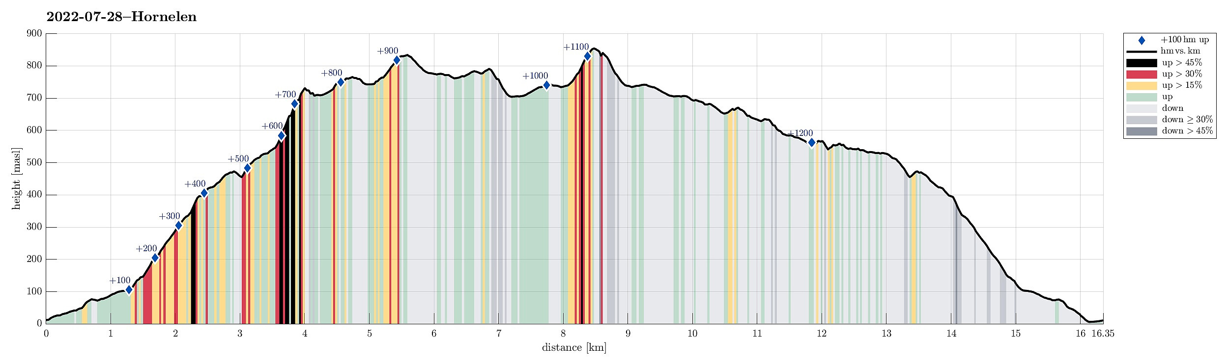
| Distance | 16.4km |
| Vertical meters | 1,280m |
| GPS |
|
| Ascents | Hornelen (858m) | 28.07.2022 |
|---|---|---|
| Storenipa (734m) | 28.07.2022 | |
| Svartevassegga (839m) | 28.07.2022 | |
| Visits of other PBEs | Parking Berleneset (10m) | 28.07.2022 |
Trip Summary
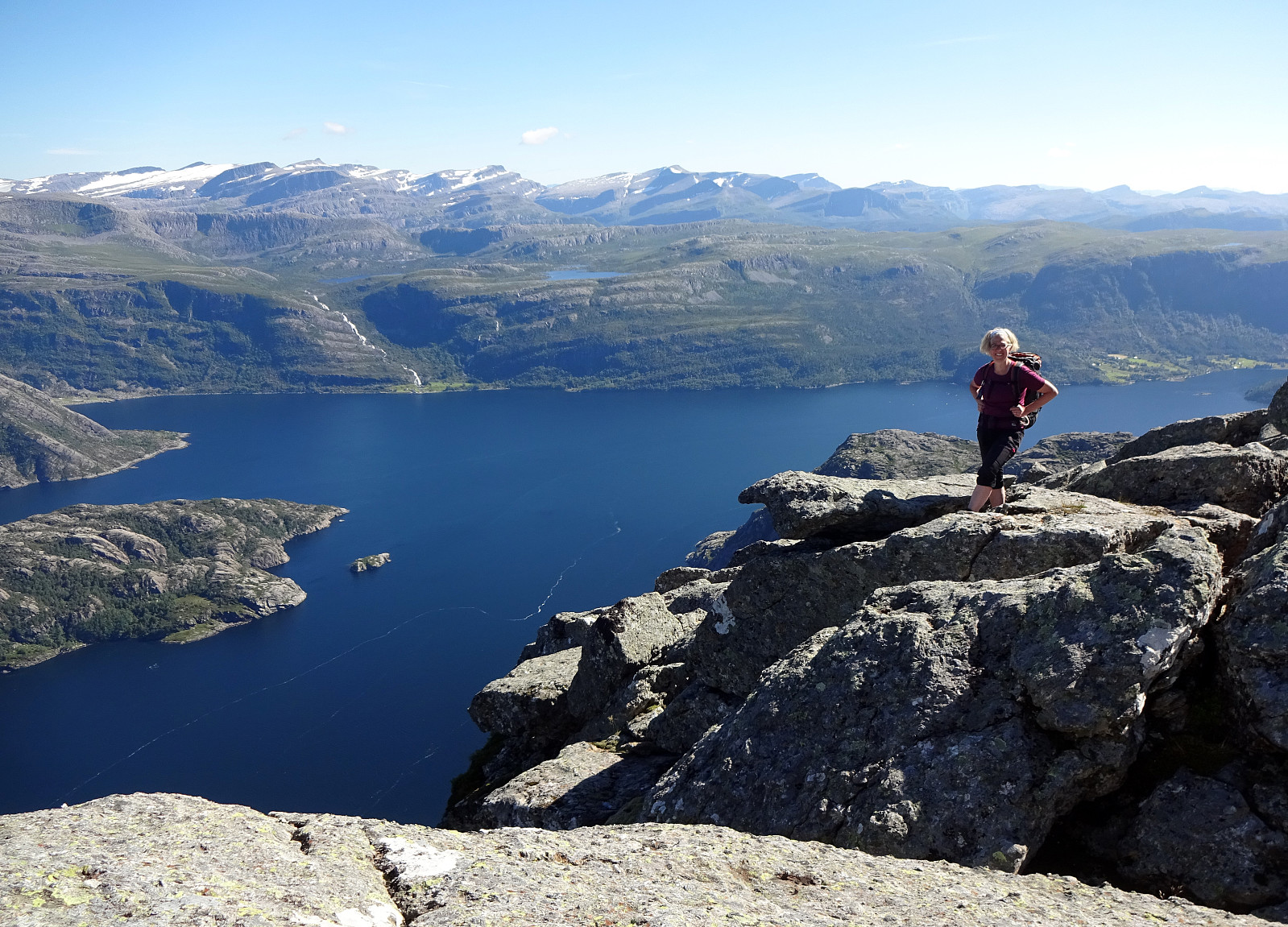
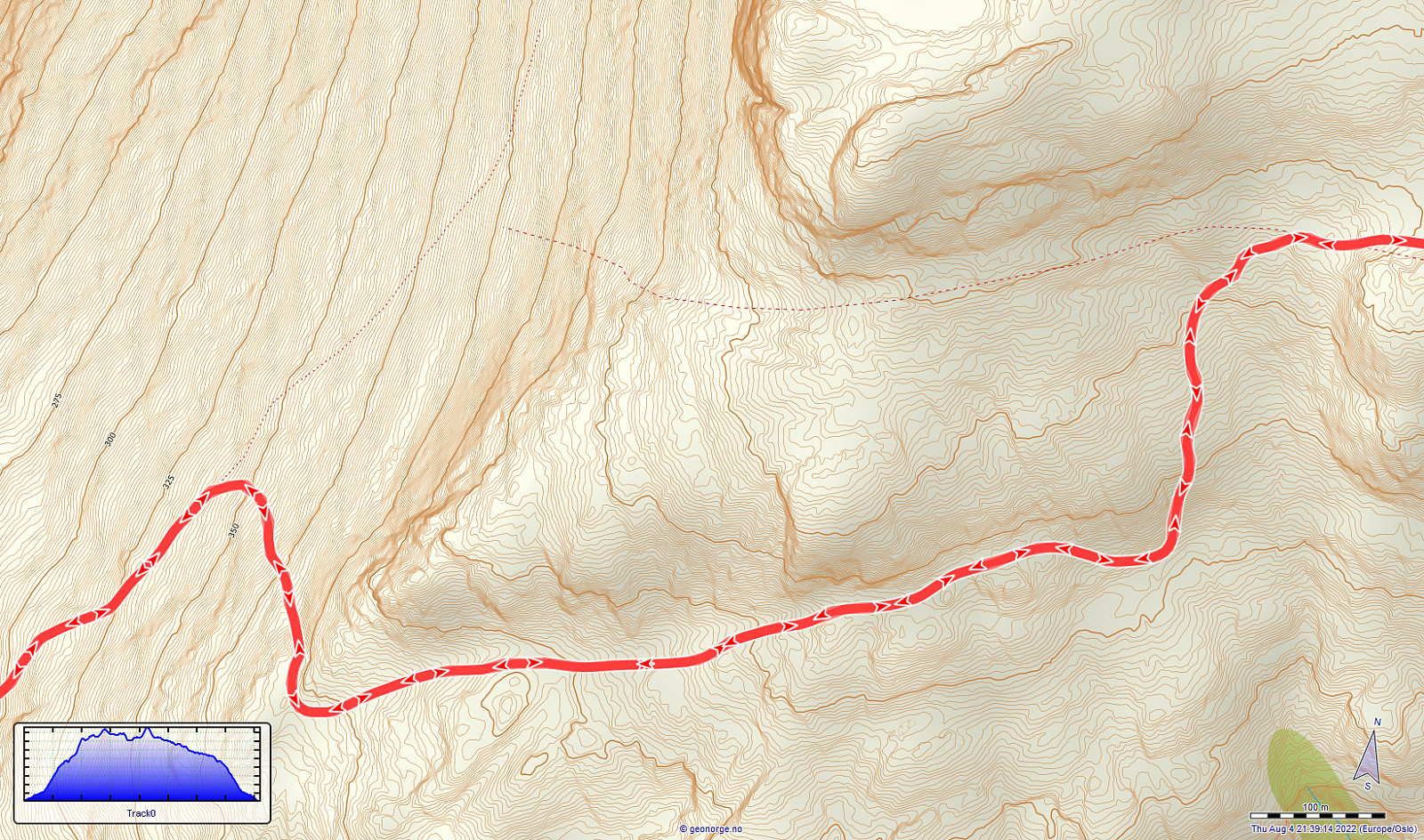
One motivation to drive all the way from Bergen to Bremanger was the prospect of hiking Hornelen, i.e., a mountain that we had heard/read repeatedly about. From the place, where we stayed over night, in the southwest of Svelgen, it's not a really long drive to get to Bremangerlandet. Especially Skatestraumtunnelen helps to get over without any waiting times. The day before, on our hike on Batalden, we had learned that ascending Hornelen from Berleneset should be nice. Accordingly, we did not follow the main trail (from Hornskor), but followed road 616 a little further to the west, before turning left and right into Berleporten, i.e., a tunnel that leads to the other, southern side of the mountains, where Berlepollen cuts deep into Bremangerlandet. More or less right after leaving the tunnel, we then turned left, again, in order to get onto the narrow road that leads out to Berleneset on the east side of Berlepollen. Almost at the end of this road, out on Berleneset, one then finds a parking place right where the trail to Hornelen starts. This trail leads first up to Åsen, before then continuing further up towards the east (via Bolshammaren). The well marked trail brings one higher quite quickly (the trail is steep, but all well within regular hiking slopes) and offers already early very nice views, both towards the north (into and over Berlepollen) and "back" towards the west (out Frøysjøen). An interesting point on this ascent is that, at about 350mosl, one meets a sign directing the hiker to a continuation of the trail in southern direction (basically making a sharp right-turn there). The quite likely reason for this sign is that the current "main trail" (with all its markings) is following a different, more lower and more southwestern route than what one finds on the map from Kartverket (see also the detail image). At about 400mosl, then, one gets "around the corner" to the southern face of the entire massive. About half a kilometer further to the east, the trail then turns left (and upwards) to reconnect to where its shown on the map (right in the west of a small lake at about 525mosl). In the west of this small lake, then, our little in-between adventure started. We had become intrigued by the idea to not "just" walk forth and back along the same trail, but to attempt a different approach, at least partially. The idea had been to include Storenipa (right in the north of this small lake) and Svartevassegga (in the northeast of Storenipa) on our way to Hornelen. A look at the map had shown that Storenipa indeed is very steep, both on its northern and on its southern side, but that its western ridge seemed doable (while also quite steep, though). Originally, the idea had been to ascend from nearby the lake to the saddle in the west of Storenipa, first, before then following the ridge up to Storenipa. When arriving at the lake, however, we spotted a comparably green "stripe" that seemed to lead up to a point just below 650mosl on the ridge (the saddle is at about 575mosl), avoiding some larger fields of fallen rocks (it was not clear from below at the lake to tell how easy or difficult it would be to get over them). Ascending to the ridge was then unproblematic (while substantially steep) and following the ridge further up to the top of Storenipa just required a bit of careful navigation (to get around some bigger blocks of rock). At Storenipa, we then enjoyed wonderful views in all directions. Continuing further, towards Svartevassegga, was then mostly a matter of stepping from stone to stone (and avoiding some overly difficult spots). Remarkably, (almost) all of the heights between Storenipa and Svartevassegga (and beyond it), are covered with rocks, meaning that "hiking" becomes a long-lasting process of searching steps (from rock to rock). Still, making progress was not really difficult and it did not take us all too long before we were ascending to Svartevassegga from its southwestern side. Also Svartevassegga, with its very steep northwestern side, offers nice views in all directions. Descending from Svartevassegga (in eastern direction) then required some extra care (with the rocks being particularly large there). Still, it did not take long before we were down at the saddle between Svartevassegga and Vestre Hornelen. There, we connected with the "main trail" (from Hornskor), which we then followed to approach Hornelen. While walking towards the saddle in the south of Vestre Hornelen, we discussed whether to include Vestre Hornelen, also, but eventually decided against it (mostly to save some time). From the saddle, the marked trail then leads steeply down into the wide valley between Svartevassegga and Hornelen. One then follows this valley upwards (in northeastern direction), surrounding a little hump near the saddle. Once around this hump, one then turns eastward and starts the final ascent of Hornelen (it's steep there, yes, and one needs to step up from rock to rock, but there are many ways to actually do this and it's not too difficult anyway). From Hornelen, as expected, one then has amazing views in all directions. The almost vertical cliff towards the east drops several hundreds of meters, almost directly into the fjord. After enjoying a nice break on Hornelen (and also looking down the cliff, of course), we then started our hike back to Berleneset. This hike back first followed the same trail that we had taken up, before then heading further southwest down the valley, surrounding Uraheia in its southeast. The trail then follows, for several kilometers, along the southern flank of the entire mountain massive (mostly in western direction), before it brings one to the little lake, where we had been before, already, again. From there, we then followed the marked trail back down (as we had followed it up, first). All in all, this hike to Hornelen indeed was very nice, offering lots of great views, not just from Hornelen itself!
Photos
Selected photos are available as Google photo album.
Useful Resources
See also the related FB-page Hiking around Bergen, Norway.
Petter Bjørstad has a useful page about Hornelen and also web page WestCoastPeaks.com provides useful information about Svartevassegga, Hornelen, Slettheia, and Uraheia.
Web page UT.no from the Norwegian Trekking Association recommends a similar hike.


User comments