
Hesjadalsnovene from Øyadalen (21.07.2022)

Written by HHauser (Helwig Hauser)

| Start point | Øyavegen (105m) |
|---|---|
| Endpoint | Øyavegen (105m) |
| Characteristic | Hike |
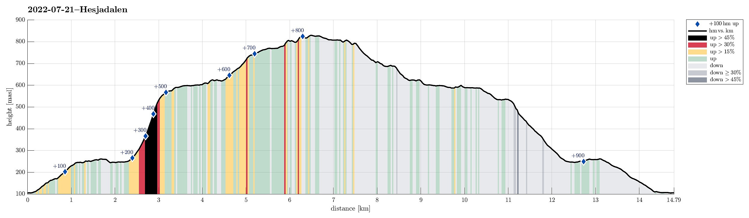
| Duration | 5h 00min |
| Distance | 14.8km |
| Vertical meters | 919m |
| GPS |
|
| Ascents | Midtnova (832m) | 21.07.2022 |
|---|---|---|
| Nordrenova (811m) | 21.07.2022 | |
| Visits of other PBEs | Øyane p-plass (105m) | 21.07.2022 |
Trip Summary
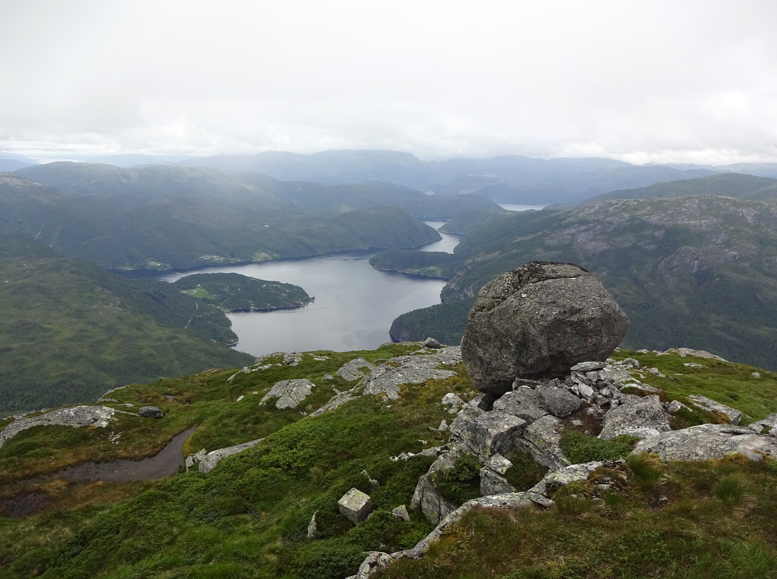
With quite some cloud cover predicted, we decided for a medium-high hike on our way back to Bergen. Driving out Eksingedalen to Eidslandet and then further along Eidsfjorden, we came to Kalland shortly after. Rounding Stamnesfjellet on the road brought us to the narrow road up from Vik to Vikadalen. Turning right right after the bridge over Vikavatnet, we arrived at the lower end of Øyadalen and parked there at a proper parking place. The map had indicated that one could choose from walking into Øyadalen either on its northwestern side, or on its southeastern one. To see it all, we decided to walk into Øyadalen on its northwestern side, first. Given the substantial amounts of rain on the day before, we quickly learned that this would turn into a very (very!) wet hike soon! :-) Yes, the lower stretches of Øyadalen (on this side) were actually providing a forest road, BUT this road was quite a bit overgrown with high (and very wet) vegetation, while the actual forest road was more like a stream in most places. So, long before the first hour was over, we had hiking boots filled with water to the rim and wet clothes even though it was not really raining. More exciting, even, we then lost the trail near Nerstølen (and the mobile phone with the downloaded map proved to enjoy a quiet day within the car). Since Øyadalen is quite steep on either side, we then had to navigate carefully over rocks and holes (well covered with vegetation!) to make further progess in the north of Træsvatnet. About half way along this lake, however, we spotted a cabin further down at the lake side. Getting there proved to then also provide us with a "trail" further into Øyadalen. Close to Dalastølen, just a bit in the northeast of Træsvatnet, we then connected with the main trail (well marked!) and progress got easier from there. Right at Dalastølen, we then took the steep trail up (in northern direction), leading up and out of the valley from Dalastølen. Stepping up the about 300hm out of Øyadalen was then enjoyable using the well-marked trail. Once our of Øyadalen, we then continued in comparably flat terrain towards Hesjadalstølen. From there, we then headed in southwestern direction, aiming at Midtrinden to ascend further up to Hesjadalsnovene. Getting up to Søranova, first, was then pleasant and enjoyable via Midtrinden (and one could even argue that also a trail is visible every now and then there!). Near Søranova, however, the weather turned a little worse, again, with low-handing clouds coming in from the west. For a short moment, we evaluated the possible risks due to limited vision, but concluded that the terrain was easy enough to read and continued our hike. Our next goal was Midtnova, just north of Søranova. Getting there was easy, but, interestingly, and in all the clouds, we first misinterpreted a small side-top, just in the south of Midtnova, for the actual top of Midtnova! :-) It took us only minutes, however, to understand that there was more to explore and we ascended to the actual top of Midtnova quickly thereafter. A bit down to the west of the top, we then found an impressively large rock, sitting there high about Hesjadalen, and conlcuded that this was a good place for a short break. After having refilled some energies, we then crossed over Midtnova and the ridge further north towards Nordrenovi, while enjoying that the coulds had opened up a little more, allowing some impressive views down to the fjord in between. From Nordrenovi, we then followed a marked trail back down. To be more accurate, however, it should be clarified that while quite a few markes could be seen, painted nicely on rocks every now and then, there was not sight of whatsoever trail. Since the heights of Hesjadalsnovene are generally easy to traverse, this absence of a trail posed no difficulty and we could get back to Hesjadalstølen without difficulties. From there, after passing by Stølsvatna, we then also included a detour via Gavvatnet, before getting back down into Øyadalen. This detour proved to be also very nice, since it brings one near to the impressive waterfall that takes water from Gavvatnet down into Øyadalen. Descending there along a well marked trail to Dalastølen was then easy and straight-forward (still very wet, though!). From Dalastølen, we then took the other route out of Øyadalen (on the southern side of Øyadalselva). This route follows actually an actually used forest road and is easy to find and trivial to walk out. All in all, we clearly returned very satisfied (and in very wet shoes, also) to our car! :-)
Photos
Selected photos are available as Google photo album.
Useful Resources
See also the related FB-page Hiking around Bergen, Norway.
Petter Bjørstad has a useful page about Midtnovi and also web page WestCoastPeaks.com provides useful information about Storfjelli, Brattanakken (Illebruni), Midtnovi (Hesjedalsnovene), and Geitafjelli.
Web page UT.no from the Norwegian Trekking Association recommends a hike to Hesjadalstølen.


User comments