
Ørnafjellet (and Lyderhorn) the "wild" way (14.11.2021)

Geschrieben von HHauser (Helwig Hauser)

| Startpunkt | Varden (45m) |
|---|---|
| Endpunkt | Varden (45m) |
| Tourcharakter | Fahrradtour gemischt |
| Tourlänge | 3h 00min |
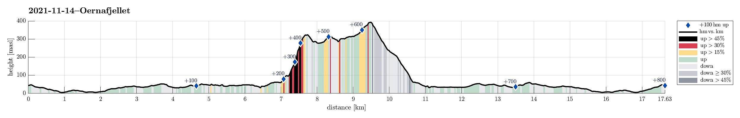
| Entfernung | 17,6km |
| Höhenmeter | 802m |
| GPS |
|
| Besteigungen | Lyderhorn (396m) | 14.11.2021 |
|---|---|---|
| Skjenafjellet (319m) | 14.11.2021 | |
| Ørnafjellet (329m) | 14.11.2021 | |
| Besuche anderer PBE | Parkering for Lyderhorn fra østsiden (30m) | 14.11.2021 |
| Lyderhornhytten (lokalitet) (396m) | 14.11.2021 |
Note that this ascent to Ørnafjellet is not easy for several reasons (steep, bush war, cliffs).
Trip Summary
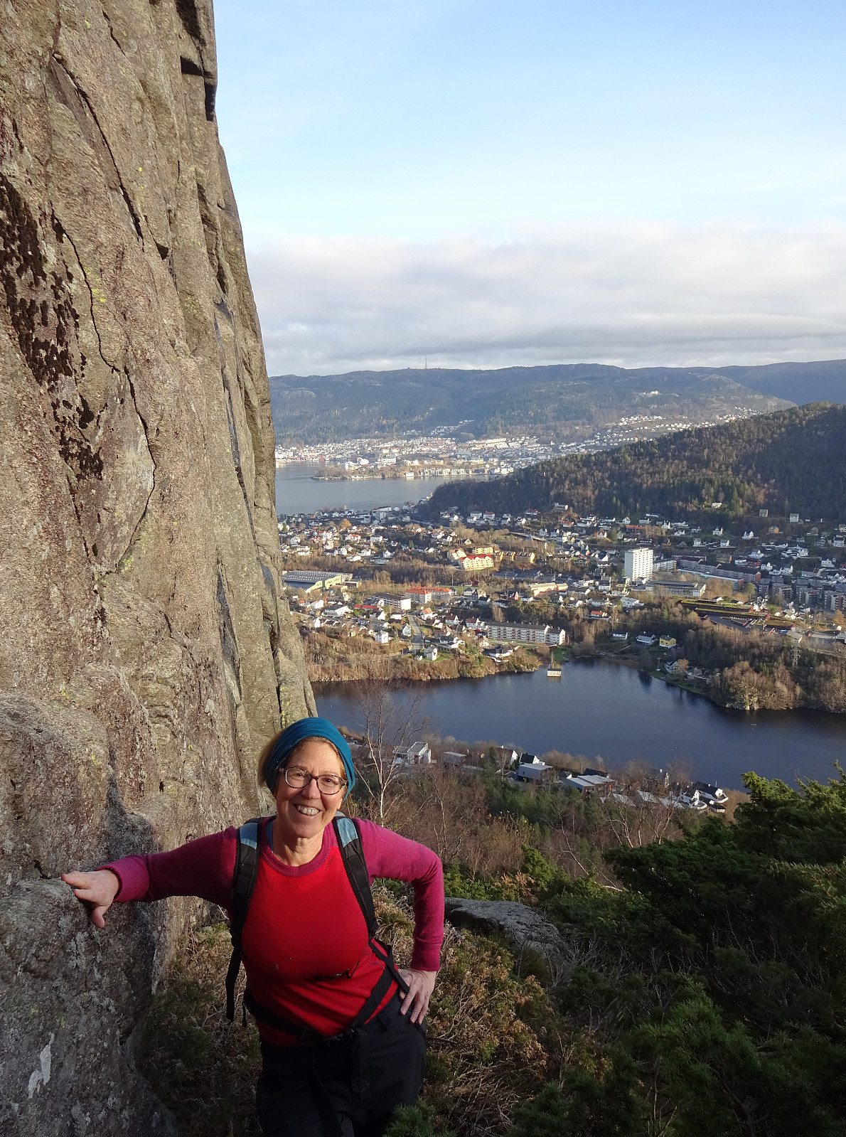
After a very nice "standard" hike to Møsnuken the day before, we wished to use the second nice weekend day for another, maybe a bit more "experimental" hike. For some time already, we had asked ourselves, whether it is possible to ascend Ørnafjellet near Lyderhorn "direttissima" from Banuren. This Sunday, we thought to try this idea. We took our eBikes and biked along Bjørgeveien into the direction of Loddefjord. After rounding Svartaberget and Bjørndalstjørna, we cycled northwards on the eastside of Lyderhorn, passing by Liavatnet. On the northeastern side of Lianakken, we turned left and onto Banuren, leading us up to the houses of Banuren. Between Søre Banuren and Nordre Banuren, where one major trail from Lyderhorn comes down, we left our bikes behind, starting our hike for a few more meters along the road, first. Near house 55 we left the road, heading northwards (and upwards). When studying the map at home, we first had thought to begin this ascend into northwestern direction (to Revura), but once there, we first followed some minor trail more in northeastern direction. We got the impression that would help us with getting on top of a cliff that separates Revura from the heights where also a string of posts is mounted. Indeed, we easily made it up to this section (where the posts are), but then the ascent (more or less following the sequence of posts upwards to Ørnafjellet) started to get more and more difficult. On the one hand, this side of Ørnafjellet is generally quite steep. On the other hand, this section is covered by comparably large rocks and getting over/around them is not always straight-forward. Furthermore, this side of Ørnafjellet is also covered by a lot of juniper bushes, of which quite some also are quite large, adding a substantial "bush war" component to the ascent. Even though we were playing with the thought to somehow bail out (for ex., by aiming further northwards), we still continued further upwards (progress was not exactly fast, there). At about 215mosl, we then came to a substantial cliff (above us). Following this cliff in western direction, we then found a way turn back northwards and do the last major "step" upwards. Once above 275mosl, the whole affair became a little easier and soon later we could indeed find ourselves on the top of Ørnafjellet. Clearly, there are much easier ways to get up there! :-) From Ørnafjellet, we then followed the regular trail down (first northwards, then around and back southwards in the west of Ørnafjellet's top). Making the small detour over Skjenafjellet is always nice as this minor top between Ørnafjellet and Lyderhorn does offer some very nice views in northwestern direction. From Skjenafellet we then continued (via Litlasåta) to Lyderhorn. Eventually, we then descended along the trail that connects Lyderhorn to Banuren. This brought us directly back to our bikes, which then brought us back home (more or less) along the same route that we had taken there before our hiking adventure. All in all, it was nice to get out; it was also interesting to explore the eastern flank of Ørnafjellet. Still, it is quite unlikely that we will follow the same route up once again. :-)
Photos
Selected photos are available as Google photo album.
Useful Resources
See also the related FB-page Hiking around Bergen, Norway.
Petter Bjørstad has a useful page about Lyderhorn and also web page WestCoastPeaks.com provides useful information about Lyderhorn and Ørnafjellet.
Web page SpillBy.com describes Ørnafjellet and
web page FotTurer.com describes a tour up Ørnafjellet.


Benutzerkommentare