
Ulriken via Ulrikseggen (17.10.2021)

Written by HHauser (Helwig Hauser)

| Start point | Tarlebøveien (115m) |
|---|---|
| Endpoint | Tarlebøveien (115m) |
| Characteristic | Hike |
| Duration | 5h 00min |
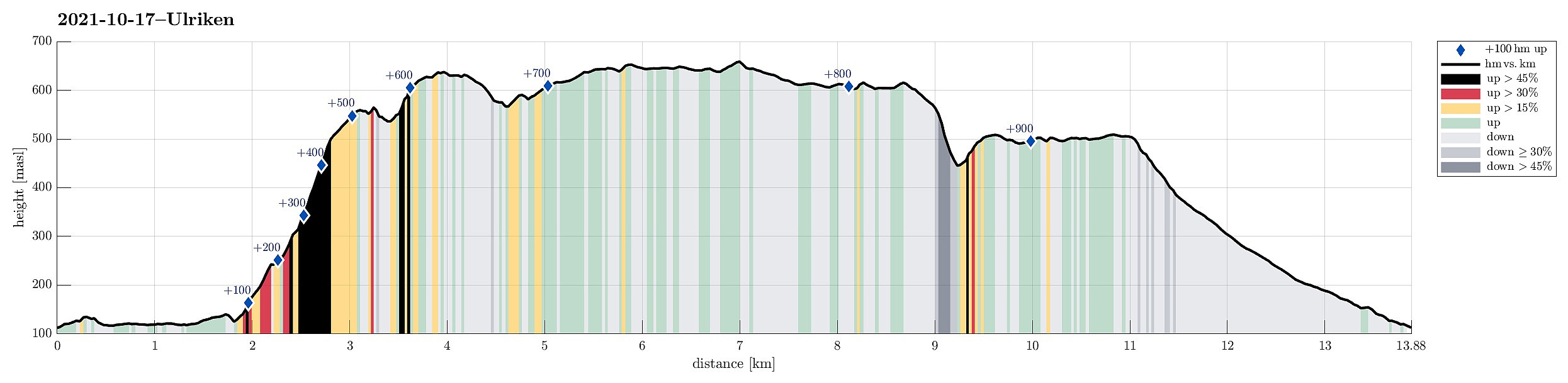
| Distance | 13.9km |
| Vertical meters | 945m |
| GPS |
|
| Ascents | Middagshøyden (640m) | 17.10.2021 |
|---|---|---|
| Storhaugen (662m) | 17.10.2021 | |
| Såtene (512m) | 17.10.2021 | |
| Ulriken (643m) | 17.10.2021 | |
| Visits of other PBEs | Bamsehi (614m) | 17.10.2021 |
| Grensestein i Borgaskaret (530m) | 17.10.2021 | |
| Borgeskarhytten (ruin) (448m) | 17.10.2021 | |
| Fjeldborg (ruin), Langelien (509m) | 17.10.2021 | |
| Fort Williams (ruin), Ulriken (635m) | 17.10.2021 | |
| Nødkjelke, Borgaskaret (604m) | 17.10.2021 | |
| Solglytt (ruin) (501m) | 17.10.2021 | |
| Steinhus i Tarlebøveien (176m) | 17.10.2021 | |
| Sæterjenten (ruin) (589m) | 17.10.2021 | |
| Tarlebødemningen (365m) | 17.10.2021 |
Trip Summary
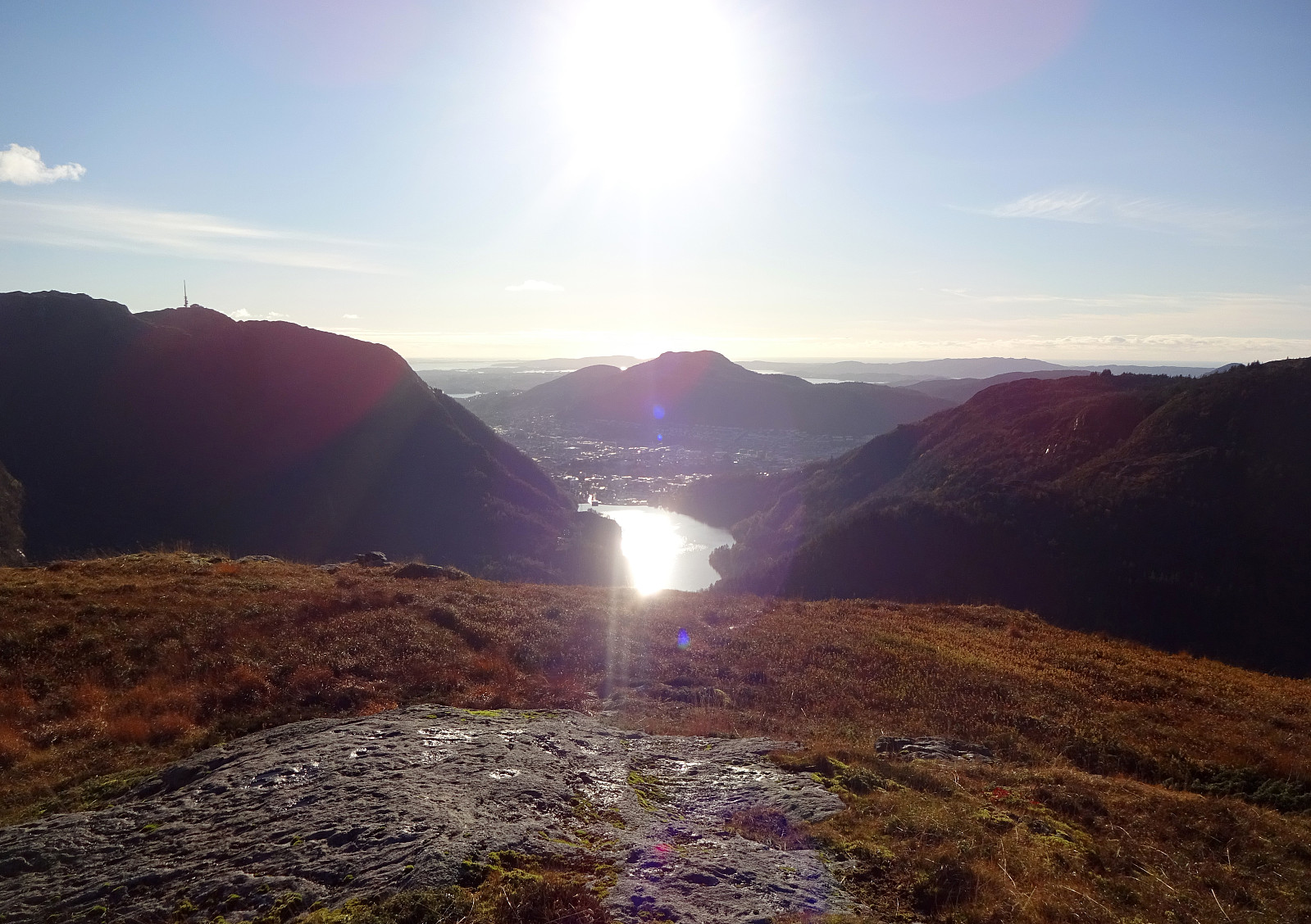
With a remarably nice Sunday ahead of us, we decided to make a round over (parts of) Vidden, starting with an ascent to Ulriken via Ulrikseggen. After first cycling to Svartediket (and a bit along it on its northern side), we started to hike not far from Koftebrotet, following the gravel road, first. This way, we passed by Hardbakkadalen and then also Isdalen, surrounding Svartediket on its eastern and then southern side. After crossing the stream that comes down Isdalen (and not following the Isdalen-trail upwards from there as one also could), we continued a little further along the gravel road until it makes a moderate turn to the right (north), leading down to Karistølen from there. It is in this turn that one can start the actual ascent via Ulrikseggen, following a trail through the forest (upwards in western direction) from there. This trail brings one directly to Ulrikseggen, where the ascent then gets steeper. Following the good trail up Ulrikseggen, we enjoyed some spectacular views (across Svartediket and towards Bergen) every now and then! Once above about 500mosl, the ridge flattens out a little and progress gets a little less demanding. Some 50 heights meters further up (and further south), one comes to a pace with a (short) zip-line. There, we decided to "cut across" to Ulriken (the actual top Ulriken, not the cable car station) via the upper edge of Ulriksskaret (basically where the warning signs are). After finding a good way to get across there, we started the last stretch of our ascent to Ulriken from its north. We found a convenient traverse, mostly over grass, that required a little bit of help from our hands in the very end (the northeastern flank of Ulriken, towards Isdalen, is very steep and one needs to be a bit careful there). Once above 600mosl, we then continued above the northern heights of Ulriken, arriving at the actual top of it soon after. From there, we headed then eastwards, including a little side-top in the east of Ulriken "along the way". Continuing further, then in southeastern direction, we got to a minor saddle, which invited us to descend further into eastern direction, where we crossed over the waters from Skomakersvatnet in the north of this little lake. This brought us to the ridge between Skomakersvatnet in the west and Trolldalen (upper end of Isdalen) in the east. Walking up this nice ridge, we connected to the main trail across Vidden soon after. Following this trail, we then walked around the upper parts of Isdalen, approaching Storhaugen on Storfjellet soon after. We then walked across Storfjellet (in northern direction) in order to get to the upper parts of Hardbakkadalen (near Skarfløyen, where Borgaskaret is on the other, southeastern side). Descending into the upper-most part of Hardbakkadalen was then steep (very steep), but without problems when taking some good care to not slip. At about 450mosl, we then came to the point, where one can choose between following the one trail further down into Hardbakkadalen, or instead ascending via Ramberget towards Langelivatnet. Doing the latter, we soon arrived at the pleasant heights in the west of Langelivatnet from where we also enjoyed some nice views across Svartediket (into the direction of Løvstakken). Surrounding Langelivatnet (in its west) and passing over Såtene, we then descended towards the dam of Tarlebøvatnet. From there, we descended through Våkedalen along the gravel road. All in all, we really enjoyed this hike quite a bit -- even though we did a short stretch along the main trail over Vidden, we still had most of this hike for us! :-)
Photos
Selected photos are available as Google photo album.
Useful Resources
See also the related FB-page Hiking around Bergen, Norway.
Web page WestCoastPeaks.com provides useful information about Haugavarden, Ulriken, Storfjellet, and Landåsfjellet
and also Petter Bjørstad has a useful page about Ulriken.
Web page UT.no from the Norwegian Trekking Association recommends a hike up via Isdalen.


User comments