
Vassenden and Store Kongshaugen (25.09.2021)

Written by HHauser (Helwig Hauser)

| Start point | Vassendveien (60m) |
|---|---|
| Endpoint | Vassendveien (60m) |
| Characteristic | Hillwalk |
| Duration | 3h 15min |
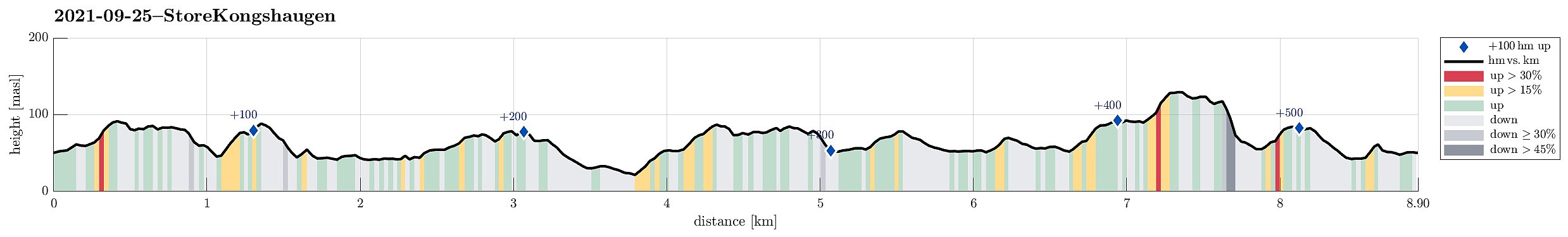
| Distance | 8.9km |
| Vertical meters | 530m |
| GPS |
|
| Ascents | Grønabrekka (94m) | 25.09.2021 |
|---|---|---|
| Store Kongshaugen (132m) | 25.09.2021 | |
| Mathopsskjenet (73m) | 25.09.2021 | |
| Nord for Medhaugsflaten (81m) | 25.09.2021 | |
| Myraskjena (87m) | 25.09.2021 | |
| Storhaugen (87m) | 25.09.2021 | |
| NØ for Ytste Rotatjørna (88m) | 25.09.2021 | |
| Visits of other PBEs | Store Kongshaugen utsiktspunkt (130m) | 25.09.2021 |
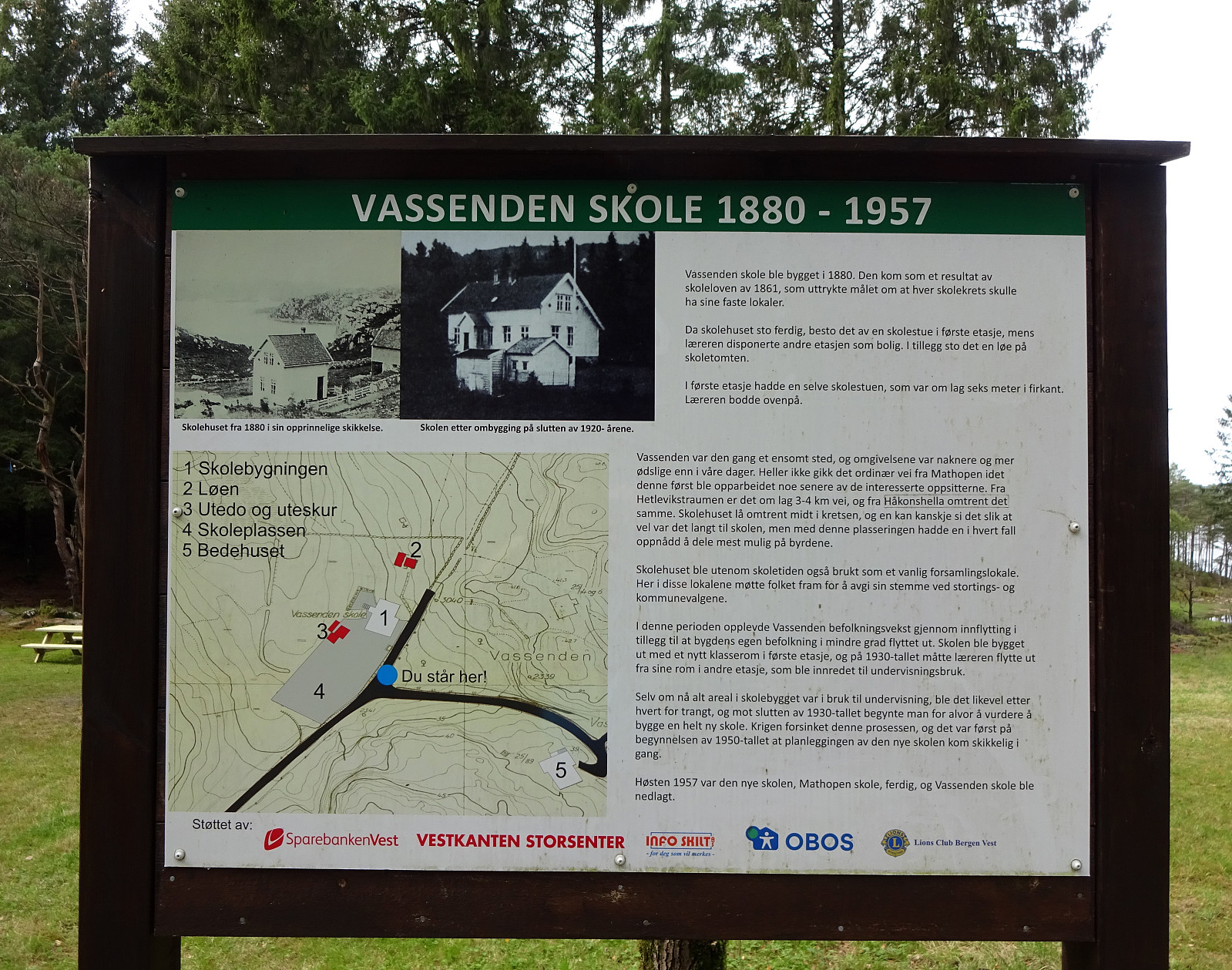
| Vassenden skole (tuft) (29m) | 25.09.2021 |
Trip Summary
I needed some fresh air and thus decided to make a short hike through the forest in the north of Store Kongshaugen. To get there, I cycled first into the direction of Haakonsvern, before turning to the right and onto Vassendveien (near the entry to the military area at Haakonsvern). Right below Ørnahaugen, I left my bike behind and started my little forest hike. I first walked in northern direction (not directly towards Vassenden though) and found a nice trail which then brought me up to Grønabrekka. Grønabrekka has some steep sides towards the west, making it really nice to traverse it along its south-north top line. After walking over all of it, I found myself not far from Høghaugen (and not far from Storavatnet, neither). I included Høghaugen via a little loop, before heading westwards along the southern end of Storavatnet. After walking a little along Storavatnet, I turned into a more southern direction (now towards Vassenden, but this time from the north). I visited two smaller hills on my way there, before then connecting with the gravel road Vassendveien, also reading a bit of information about the no longer standing previous school there. After following the gravel road for just a few meters, I found a nice trail up to Inste Rotatjørna. From there, I then ascended to the little hill in the northeast of Ytste Rotatjørna, before crossing over to Myraskjena from there. From Myraskjena, I then headed southwards (to Torvmyra) to surround Ytste Rotatjørna in its southwest. After including a small hill in the south of Ytste Rotatjørna, also, I followed a trail towards the northeast (between Ytste and Inste Rotatjørna). Once I had passed by Inste Rotatjørna (for the second time, but now in the opposite direction), I took a turn onto another trail that would bring my up to Mathopsskjenet. Following this trail southwards, I shortly later arrived at Kattatjørna. From there, I headed further southwards (and into the direction of Store Kongshaugen). First, however, I "ended up" in the west of Store Kongshaugen (Sætre), before then approaching Store Kongshaugen from its western side. This side of Store Kongshaugen is very steep and I found a (very) minor "trail" that would "wind up" to Store Kongshaugen via its northern slope (parts of this minor "trail" brought the need for a bit of climbing, also. Still, it was eventually just a matter of some minutes, before I arrived at the top of Store Kongshaugen. I then crossed over it to catch some views from it towards the south. Next, I needed to descend again from Store Kongshaugen and I decided to try a somewhat direct route (in northeastern direction). Given the steep and wet terrain, this turned out a bit more challenging than what I really needed and I was glad as soon as I had made it back down (and onto a little gravel road in the northeast of Store Kongshaugen). From there, I then crossed over to the other side (in eastern direction) and found a nice trail that would bring me up to Storhaugen. I then crossed over Storhaugen (from its south to its north), before I came down to a little lake in the north of Storahaugen. From there I then found a way to get back to my bike. All in all, I found that this round was eventually a little bit longer than the originally envisioned quick refreshing hike that I had planned up-front. Still, it was nice to get out and this area has lots of nice places to offer (a number of small lakes, plenty of nice trails, etc.).
Photos
Selected photos are available as Google photo album.
Useful Resources
See also the related FB-page Hiking around Bergen, Norway.


User comments