
Sveningen via Åsen from Brekkedalen (12.09.2021)

Geschrieben von HHauser (Helwig Hauser)

| Startpunkt | Hausdalen parking (95m) |
|---|---|
| Endpunkt | Hausdalen parking (95m) |
| Tourcharakter | Wanderung |
| Tourlänge | 6h 30min |
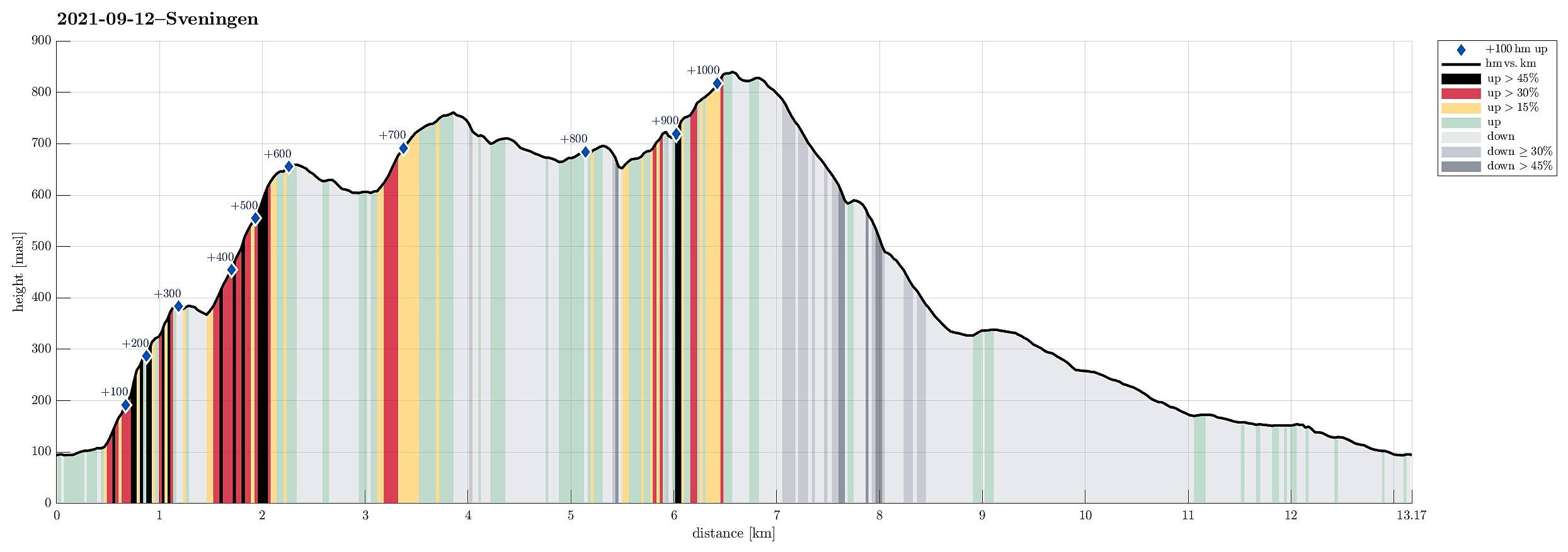
| Entfernung | 13,2km |
| Höhenmeter | 1.068m |
| GPS |
|
| Besteigungen | Sveningen (842m) | 12.09.2021 |
|---|---|---|
| Søtefjellet NV (762m) | 12.09.2021 | |
| Åsen i Samdalen (389m) | 12.09.2021 | |
| Besuche anderer PBE | Hausdalen parkering (94m) | 12.09.2021 |
| Åsen søyle (385m) | 12.09.2021 |
Trip Summary
The weather forecast has been promising (very promising), even in the morning, so what could go wrong? :-)
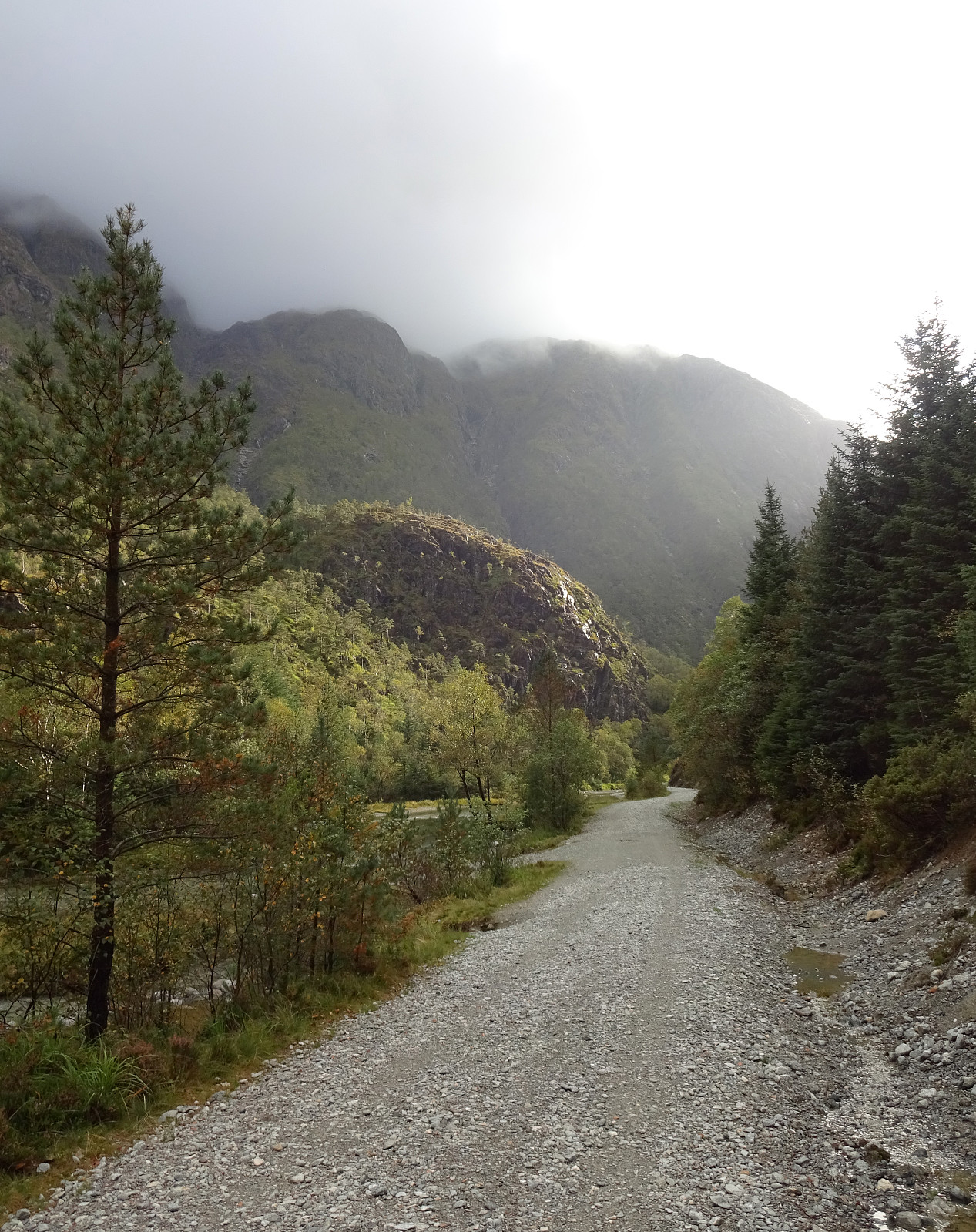
Considering the expected day full of sunshine and pleasant hiking temperatures, we aimed at something slightly "bigger" and since we had not visited Sveningen recently, we planned a nice hike over this mountain! To make this a bit more interesting, we decided to include an ascent that we had not tried before (and of which we also could not find any other report from others), i.e., up to Åsen, first, from the north, and then over the northernmost part of the Sveningen massif (in eastwards direction, kind of "parallel" to Brekkedalen in the north of it). To get started, we drove into Hausdalen (from E39, south of Bergen) and all the way into it (until the parking place at the very end of Hausdalsvegen). Already while driving there, we started to ask questions about the weather (and whether it in fact would be so sunny as the forecast said). The clouds were hanging thick and low, providing no view towards the nice mountain tops around Hausdalen. When leaving the car at the end of Hausdalsvegen, we started to assume that it at least would take longer than predicted. When studying the map in advance (at home), we got the impression that it should be possible to ascent to Åsen from its north (out of Brekkedalen), following a narrow valley that extends from the north of Åsen in northeastern direction down to Brekkedalen. To get there, we needed to cross the river in Brekkedalen. On the map, again, we had seen that there would be a bridge near the camping area in the southwest of Storhaugen, and crossing it there would lead us more or less directly towards this little valley. Once there, however, we were shocked given the state in which this "bridge" actually was/is. Having (previously) been a simple suspension bridge, supported underneath by two suspended steel strings across the river, it now hang kind of loose from one of the two steel strings. There were reasons to wonder whether (a) this "bridge" would still support the weight of one person and (b) whether this person would possibly fall off the "bridge" and into the white water underneath. After a bit of consideration, we decided to give it a try and one of us traversed the "bridge", while the other one was waiting. This worked, even though it was not easy to avoid falling off the "bridge" sideways, given that one of the two support strings was not really providing any mentionable counter-force. With one on the other side, it was now the turn of the other one to engage with this questionable river-crossing challenge. Fortunately (more luck than anything else?), also this worked and so both of us were "on the right side" of the river, ready to re-focus on the ascent to Åsen! After crossing over some pretty wet terrain south of the river, we started the ascent more or less in exactly southward direction. This ascent quickly became quite a bit steep, but stepping up carefully was no problem (it just was very wet since all the vegetation through which we had to proceed was covered by a substantial amount of water!). A bit above 150mosl then, we turned into a more southwestern direction, entering the targeted valley from there. While very wet, still, it then was no big problem to further ascent through the valley -- at about 200mosl, it's a bit steep, but all in all this ascent works quite well. From 250mosl onwards the valley becomes less steep and we had no major difficulties to continue further upwards through it (on its southeastern side). At about 320mosl, we then decided to exit the valley towards its south and to aim at Åsen via this somewhat more direct line. This worked well even though this part was quite a bit steep and since everything was very wet, we had to take extra care to not slip off the rocks there. Not long later, however, we had well arrived at the "top" of Åsen then, unfortunately, however, without any views as we were completely immersed within a thick and low-hanging cloud. Next, we aimed at the continuation in southeastern direction, leading us further upwards into the direction of Søtefjellet/Sveningen. Having done his part not too long ago already once on a nice and sunny day, we were confident that we would find our way up there without major difficulties. Indeed, this ascent was nice and without difficulties, just taking some special care due to the wet and slippery rocks. Deviating from our other ascent up there, we this time wished to cross over the heights in the north of a nice lake up there. This seemed to work nicely, also, even though we had close to zero visibility in the thick cloud. Knowing that we would have to find a place a little further south in order to cross over and around a few small lakes there, emptying through steep gullies towards the north from there, we turned a bit towards the south, once on the heights in the northeast of the lake. Unfortunately, this brought us a bit too far down so that we missed the chance to cross over "to the left" (east). Not recognizing at once in the thick cloud that we had deviated substantially from our originally planned "track", we only checked the map, again, when already quite a bit "too far" to the southwest (and in the south of the lake). Once looking at the map, again, however, clarified our situation and could adjust our plan to get "back on track", again. Plan B then was to first ascent to Søtefjellet (the northwestern "side-top" of it, to be specific), first, and then connect to the trail, crossing over the southeastern ridge of Søtefjellet, from there. Since we had been up there a few times, already, we were confident (for good reasons, this time!) that we would find the trail, even with close to zero visibility. As expected, this plan worked and soon later we arrived at the "main trail" over Osvidden. Once on the trail, the continuation of our hike was much more straight-forward then, of course, and we hiked along the ridge towards Sveningen. Unfortunately, we had to still wait for the clouds to lift or break open; in fact, we ended up on Sveningen with about 25m of visibility (virtually nothing). Once on Sveningen, and instead of enjoying some nice views, we decided to continue right away, starting the next challenge (to find the way down across the northeastern ridge of Sveningen). Since no trail is sufficiently well visible in this direction, we had to rely on mini-cairns that indicate the direction every now and then. With extremely limited visibility, this turned into bit of hide-and-seek game with the cairns "trying to hide" from us! :-) With a few (quickly corrected) detours, however, we registered us well to this "trail" and followed the cairns down along the ridge. When down to about 625mosl, we apparently started to step out of the cloud, providing the first long-distance views on all of this hike! :-) After several hours in a thick cloud (and quite a bit of concentration to not get lost!), it was extra-positive to suddenly see "something"! :-) From there, it was then nice and relaxed to finish the descent along this ridge, ending up in the east of Litla Brekkevatnet soon. After passing by Litla Brekkevatnet (in its east), we then stepped out and onto the gravel road through Brekkedalen. From there, we then walked down through Brekkedalen back to our car. All in all, it was quite an experience to ascend to Sveningen off-trail with (close to) no visibility (and to get lost for a short stretch, also). All of this was without any real danger (we did not end up in extremely steep terrain, for example), but it certainly adds to the respect for special conditions in the mountains (changing weather etc.). Most dangerous, maybe, and after all, was the crossing of the "bridge" at the very beginning of the hike!
Photos
Selected photos are available as Google photo album.
Useful Resources
See also the related FB-page Hiking around Bergen, Norway.
Web page WestCoastPeaks.com provides useful information about Sveningen, Søtefjellet, Sauskolten, Rindafjellet, and Midtsæterfjellet
and also Petter Bjørstad has a useful page about Sveningen.


Benutzerkommentare