
Storeggene, Rabben, Blåfjellet, and Arnipa (12.07.2021)

Written by HHauser (Helwig Hauser)

| Start point | Tveit (30m) |
|---|---|
| Endpoint | Tveit (30m) |
| Characteristic | Hike |
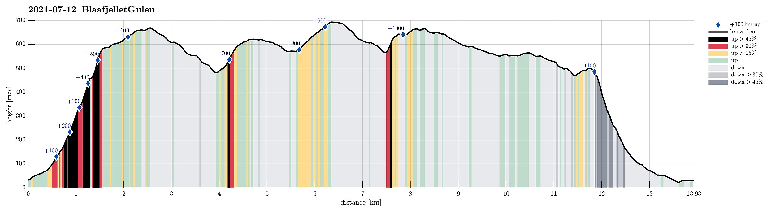
| Duration | 6h 30min |
| Distance | 13.9km |
| Vertical meters | 1,122m |
| GPS |
|
| Ascents | Skåldalsnova (695m) | 12.07.2021 |
|---|---|---|
| Storeggene (673m) | 12.07.2021 |
Trip Summary
On our way from Bergen to Solund, we wanted to include one hike in Gulen. When checking the map for opportunities, reading also another trip report here on Peakbook, we got tempted to go a nice round in the east of Nordgulen. In order to get to the starting point (at Nordgulen), we drove northwards from Bergen, leaving road E39 at about Knarvik to continue to Mongstad from where we then took a ferry over to Sløvågen. From there, we continued along road 57 (into the direction of Rutledalen), driving first along Eidsfjorden and then further along Nordgulfjorden. Only several hundreds of meters from the northern end of Nordgulvågen, we left road 57 towards the east in order to park somewhere in the area of Tveit. After asking one of the locals, we conveniently parked right next to a playgroud in the northeast of Tveit.
Storeggene
Already impressed by the views from down in the valley (Tveit is basically surrounded by very steep mountain sides to the north, east, and south), we started our hike into northern direction, aiming at Gjemliskaret first. Following a well-marked trail on the eastern side of Gjemlielva, we quickly gained height in the steep terrain. Given the warm summer temperatures, this also generated a sufficient amount of transpiration right away! :-) At around 400mosl, it really payed off to turn around and enjoy a wonderful view across Tveit and further to Nordgulvågen, appearing in an intense cyan color that likely is due to some blooming of algae in the water! About 200 height meters further up, the terrain then "flattens" out quite a bit with a large variety of options of where to go next. Our first top, Storeggene, was then also close, already, just a bit further to the north, offering some very nice views, also far into the distance (on Storeggene there's actually a board that informs about which landmarks one can see, also in the far distance).
Rabben, Blåfjellet, and Arnipa
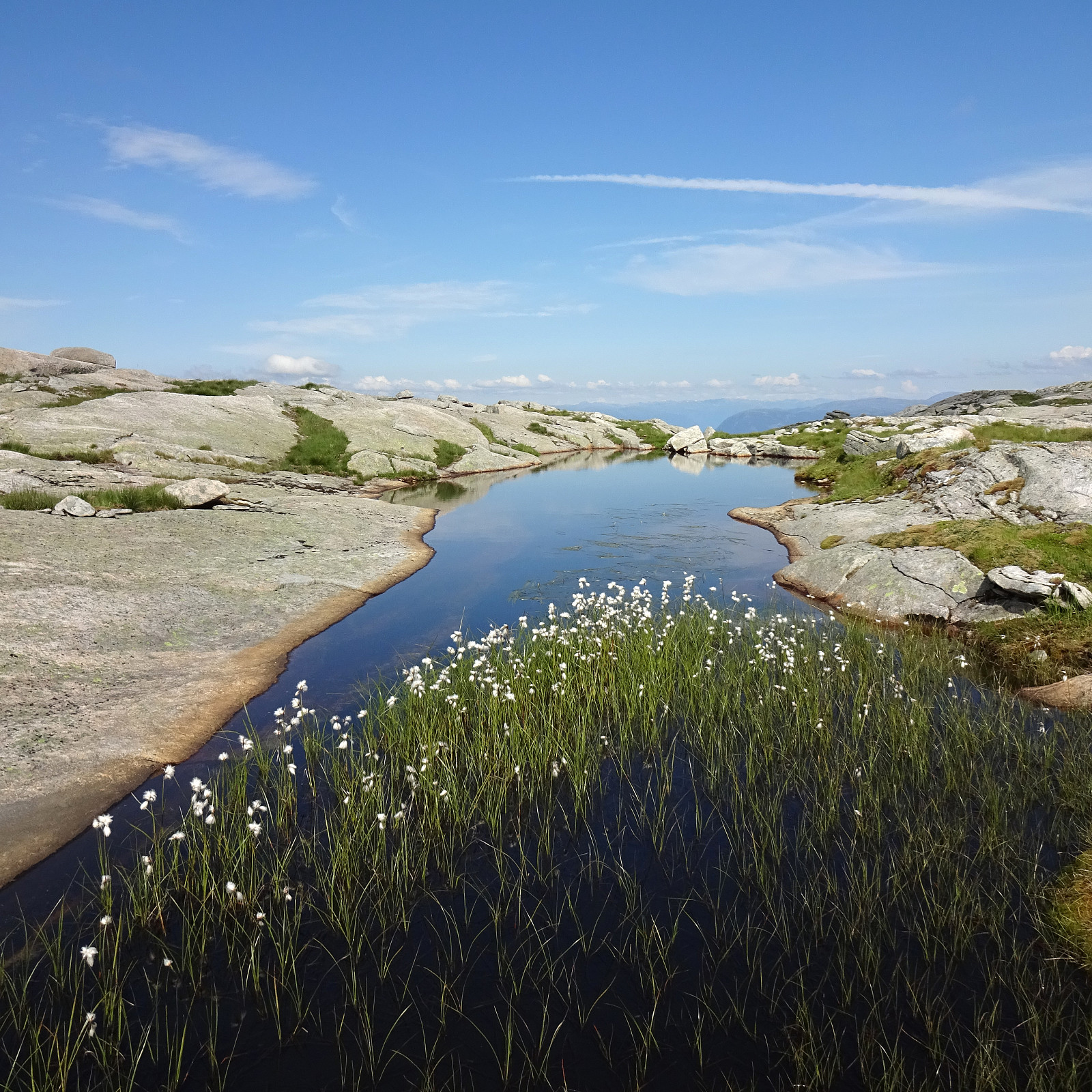
From Storeggene, we then headed eastwards to take Vestredalen down before crossing Dundalen not too far south of Langevatnet. Instead of heading directly towards Blåfjellet, we also included Rabben in the north of Blåfjellet. On Rabben (at the southwestern end of its high ridge), we enjoyed a nice overview of Dundalen, before then heading down to Blåfjellstjørna in its southeast. There, we refreshed ourselves in the lovely waters of this saddle lake. Next, heading further south, was then Blåfjellet and its southwestern point Skåldalsnova, which provides one with a great view over the much lower Skåldalsvatnet and the steep cliffs that surround it on almost all sides! From there, we then continued (in southeastern direction) towards Arnipa. After crossing over Arnipa, we started to head back and to do so we first needed to connect to Havelandsstølen, high above Skåldalsvatnet (and in its south).
Way back
We started our descent from Arnipa following a "diagonal" path in southwestern direction (more or less into the direction of Hellebergsvatna). This descent turned out to be surprisingly easy (and thus also fast), walking over large, level stone plates almost all the way! Once we had passed by Hellebergsvatna (in its north), however, when also having reconnected to the trail down from Hallane, the terrain became slightly more demanding, again (but no problem at all). A short while later, we then approached Havelandsstølen from its northeast. To actually get down, it then was essential to cross Omnelva near Omnstjørna and include a short ascent (in northwestern direction) from Havelandsstølen, before starting the actual descent towards Øykegardhaugen. This final descent is then very steep, even though it follows a "diagonal" course along the east-west stretching mountain side, and some special care is needed to get down there safely. Once down to Øykegardhaugen, the terrain gets easier to walk over, again, and a little further west, in the south of Tveitekletten, one can cross Skåldalselva using an impressive old stone bridge and then surround Tveitekletten on its western side to get back to Tveit.
Conclusion
All in all, this hike was really very nice. It is also kind of special as most of it is atually "on top" of the mountains that surround Tveit (with a steep ascent to begin with and a steep descent at the end).
Photos
Selected photos are available as Google photo album.
Useful Resources
See also the related FB-page Hiking around Bergen, Norway.
Web page UT.no from the Norwegian Trekking Association recommends a hike that follows a similar ascent in the beginning.


User comments