
Storekvitefjellet, Lauvåsen, Naknekampen, and Høgeåsen (08.05.2021)

Skrevet av HHauser (Helwig Hauser)

| Startsted | Fanafjellsvegen (65moh) |
|---|---|
| Sluttsted | Fanafjellsvegen (65moh) |
| Turtype | Fottur |
| Turlengde | 3t 30min |
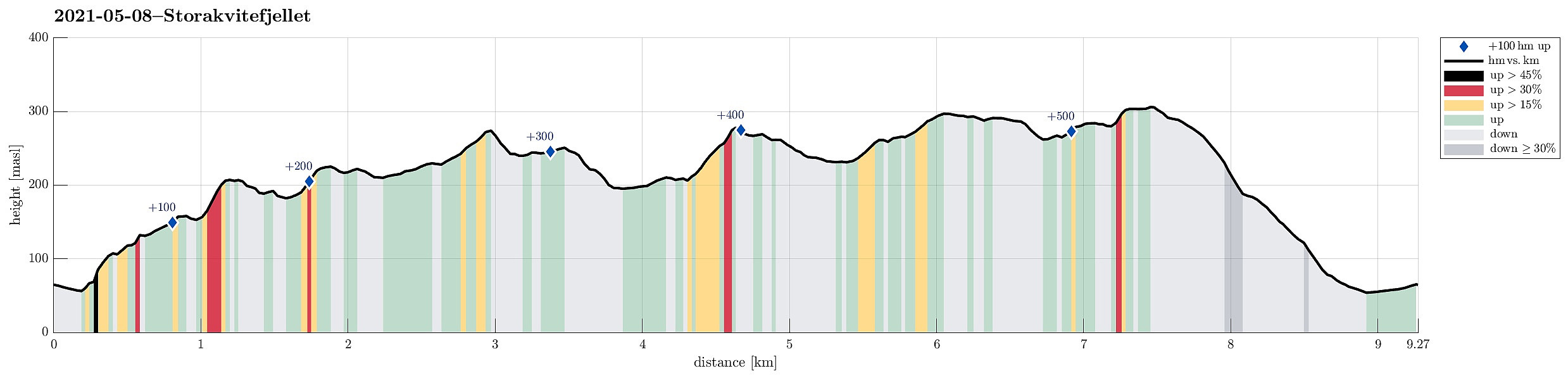
| Distanse | 9,3km |
| Høydemeter | 552m |
| GPS |
|
| Bestigninger | Fanasåta (284moh) | 08.05.2021 |
|---|---|---|
| Høgeåsen (309moh) | 08.05.2021 | |
| Lauvåsen (277moh) | 08.05.2021 | |
| Ramberget i Fana (300moh) | 08.05.2021 | |
| Storakvitefjellet (212moh) | 08.05.2021 | |
| Andre besøkte PBE'er | Fanegrind (295moh) | 08.05.2021 |
| Storakvitefjellet utsiktspunkt (209moh) | 08.05.2021 |
Trip Summary
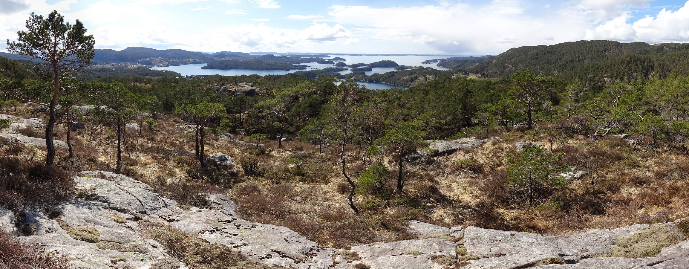
After starting our day with some scepticism regarding the expected weather, we then decided to still head for a nearby hike. Double-checking the weather prediction map suggested that the south of Bergen may see somewhat better wheater. We thus aimed at a hike there, not too far from Bergen, and since we had not been on Storekvitefjellet, we decided to give it a try. :-) After first driving to Fana, we then crossed Fanafjellet von Fanafjellsvegen until we came close to Nordvika on the southern side of Fanafjellet. There we parked next to the road and started our hike towards Stonghaugen, first. The southwestern side of Stonghaugen is a bit steep, but not really any problem to get up to. Already a bit up there, we enjoyed our first nice views back to Nordvika. From Stonghaugen, it then was a pleasant hike through the forest in northeastern direction, ascending Storekvitefjellet step by step. Near the top, the forest opens up and one has more nice views, especially out Lysefjorden. After crossing Storekvitefjellet, we rounded some boggy area near Trollbotn and continued further upwards (still in northeastern direction). This brought us up to a little hill in the west of Nilsatjørna. From there, we continued across a rather level area with trees and some wet areas in northern direction (towards Lauvåsen). Even though we did not really see any major trail up to Lauvåsen, we still could not resist to step up to its top. :-) We then descended (a little steep) in northwestern direction and passed by a lovely little pond once we where down there. We then connected to a trail, which brought us to Jordavatnet within a few minutes. We then continued from there into the direction of Naknekampen, following a proper trail most of the time. After crossing a gravel road in the northwest of Jordavatnet, we first followed a trail for a few meters, before turning right and ascending to Naknekampen from its south (this hillside is quite steep, but when choosing a proper route, it's no big deal to ascend also from this side). At Naknekampen, we then enjoyed a short break with lovely views over Søre Sædalen, before continuing into the direction of Fanasæter. There, after crossing Fanafjellsvegen right at the saddle, we followed the main trail and got up to Ramberget first (the panoramic view across Fanafjorden from there is really nice!). From there, after first passing by Fanegrind, we headed towards Høgeåsen. Even though we could not really identify any major trail up to Høgeåsen, we still found it easy and straight-forward to get over and up there. Once across the top of Høgeåsen, one really can enjoy some lovely views down (southwards) to Lysefjorden! :-) Further, we found it then really nice and enjoyable to descend over the gentle southern slopes of Høgeåsen, avoiding its somewhat steeper western side. From about 250mosl, then, we turned a bit more towards the west (towards Midtåsen). This brought us down into a small (and nice) valley (in the southeast of Midtåsen), which we then followed down until we connectd with the trail Moldstigen (in the valley in the southwest of Midtåsen). It then only remained to walk around Klubnehaugen near Nordvika and return to Fanafjellsvegen and our car. While only planned as a little, non-spectaculy hike, we after the fact found the chosen round really very nice and would recommend it also to others (maybe not in particular wet conditions). Great to have such amazing hiking opportunities almost within the city limits! :-)
Photos
Selected photos are available as Google photo album.
Useful Resources
See also the related FB-page Hiking around Bergen, Norway.


Kommentarer