
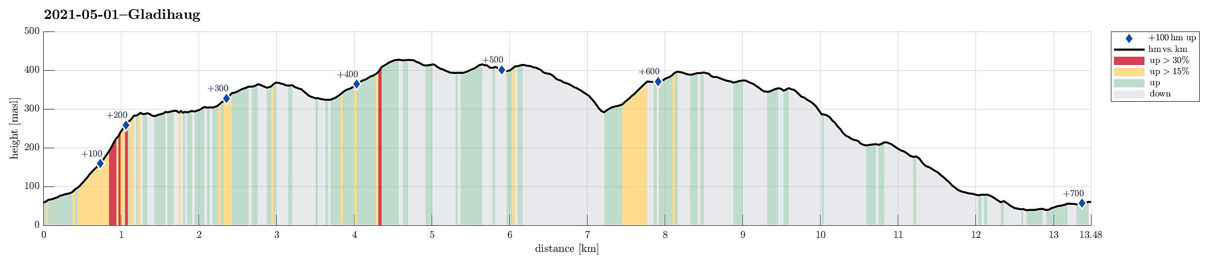
Gladihaug and Krossane from Votno (01.05.2021)

Geschrieben von HHauser (Helwig Hauser)

| Startpunkt | Votno (60m) |
|---|---|
| Endpunkt | Votno (60m) |
| Tourcharakter | Wanderung |
| Tourlänge | 4h 00min |
| Entfernung | 13,5km |
| Höhenmeter | 705m |
| GPS |
|
| Besteigungen | Gladihaug (430m) | 01.05.2021 |
|---|---|---|
| Krossane (399m) | 01.05.2021 | |
| Besuche anderer PBE | Krossane utsiktspunkt nord (397m) | 01.05.2021 |
Trip Summary
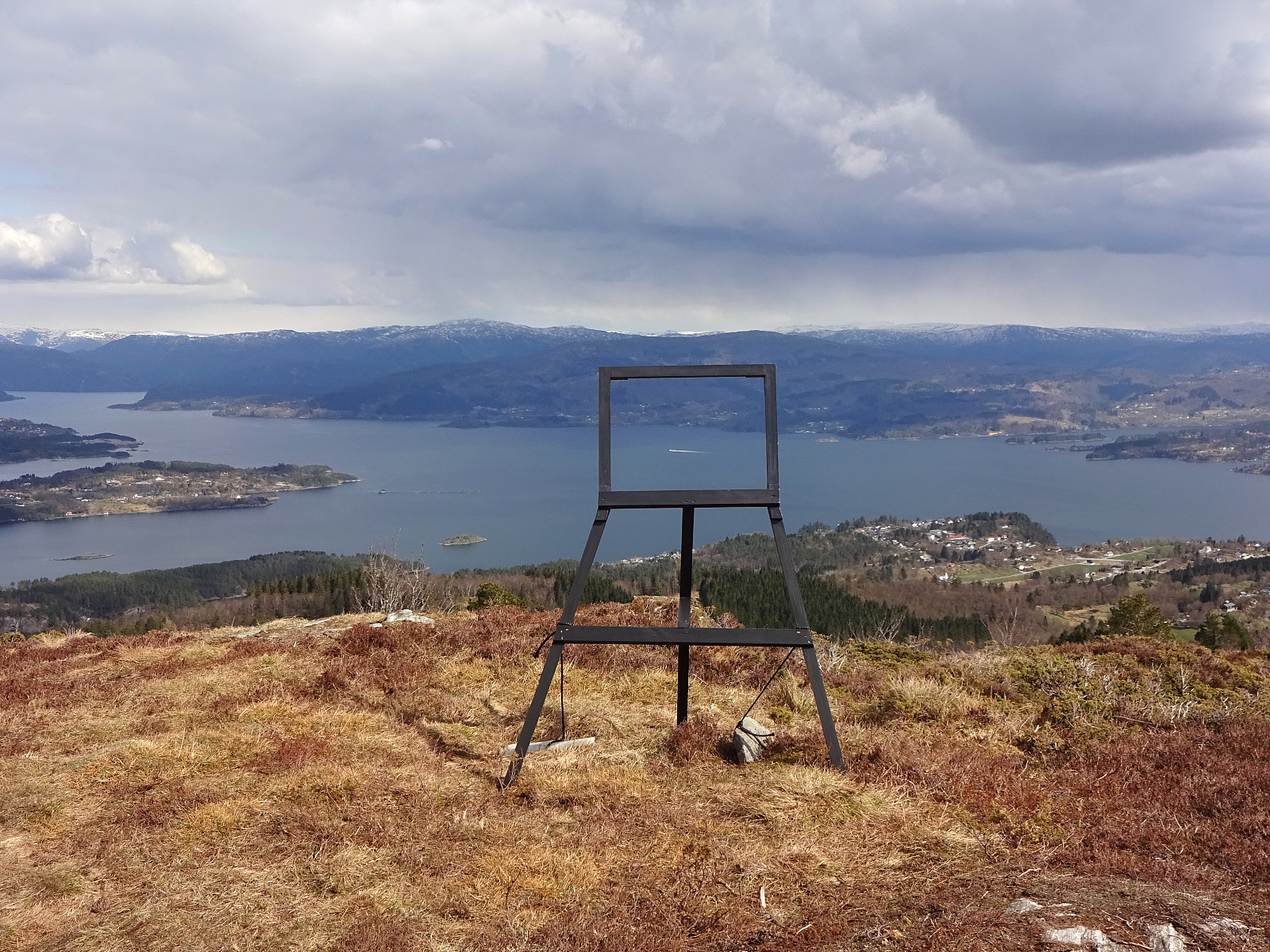
For a while, we had contemplated to hike Gladihaug one day. This morning, we decided to finally do it! :-) We took the car to the north of Bergen, driving along E39 towards Knarvik. Once there, we turned left in Knarvik and continued along road 57 (into the direction of Mongstad in the north of Knarvik). After driving through Espelandstunnelen and Herlandstunnelen on Lindåsvegen, we parked right next to the road (where one also could drive off to Seim only a bit further in the north). We then started our hike towards Gladihaug by walking into Votno, approaching the significant ridge of Hellefjellet from its north. As soon as we found ourselves on this ridge (in the south of Votno), we also had found a simple trail that was easy to follow. At about 250mosl, this trail even got "upgraded" by selected marks along the trail. Stepping up onto the steep ridge of Hellefjellet, we soon enjoyed some nice views, especially towards the north and west. After crossing over Hellefjellet, the trail situation became a little less clear (it seemed to us as if it would lead down to Lågedalen, again). Since we wished to continue along the ridge, we followed what more looked like deer trails. Still, it was not difficult and we soon arrived at the highest point on this ridge (a little less than 370mosl) in the north of Breimyra. Continuing from there, we soon arrived at a special place in the northwest of Breimyra, where the remains of several old stone building impress. After passing by Breimyra (on its western side), it wasn't very long before we arrived at the top of Gladihaug. After enjoying the views from Gladihaug for a moment, we continued to one of the ridges that extend into the southeastern direction from Gladihaug and where we had the impression that one should have some nice views towards the south (across Osterfjorden to Osterøy). After passing by the first cairn on this ridge, we continued a little further, reaching an interesting place (at about 400mosl), which reminded us of a stone gate to walk though. After first enjoying the view from there, we then had a short break at this stone gate before heading back up to Gladihaug. Once back on the "main trail", leading towards the east of Gladihaug, we followed towards the south of Varden (where the big mast also stands). Before turning left (and up to Varden), we had a bit of fun at an empty frame there that suggests that the view through it is like a painting. :-) We then crossed over Varden (in northwards direction), passing by the big mast there. After looking out for a trail in the north of Varden for some minutes, we rejoined one of the major trails on the north ridge of Varden. At about 350mosl, this trail turns a little off the ridge (towards the east), leading down Brunena. Once down to a little below 300mosl, we joined another trail, which comes up from Hopsdalen there, and continued on it (again in northern direction), starting our ascent to Krossane. While walking up towards Krossane, we recognized a number of major cairns near the top. Not staying any mentionable time on the top, we continued further northwards along the ridge in the north of Krossane. Also this ridge offers a number of nice views, especially also further north of Krossane. The last high point with really nice views, in fact, is then Storevarden in the north of Krossane. From there, the trail leads down through the forest and once we came down to a bit below 225mosl, we turned left at a sign pointing to the left (west), identifying a connection to Vatne. Following this connection, we passed by the larger wet area in its south and very soon came to a nice forest road, leading gently down to Vatnedalen. Once down in Vatnedalen, we walked it all out, passing underneath Lindåsvegen while doing so, and arriving at Seimsvatnet soon after. We then passed by Seimsvatnet in its south, following the farm roads there. A few minutes later, we connected back to where we had started in the beginning. All in all, it was positive to find out that quite number of places around Gladihaug indeed offer nice views in all directions! :-)
Photos
Selected photos are available as Google photo album.
Useful Resources
See also the related FB-page Hiking around Bergen, Norway.
Petter Bjørstad has a useful page about Gladihaug and also web page WestCoastPeaks.com provides useful information about Gladihaug.
Web page UT.no from the Norwegian Trekking Association recommends another hike from Votno to Krossane.


Benutzerkommentare