
Lyderhorn via Lia (17.04.2021)

Written by HHauser (Helwig Hauser)

| Start point | Lyderhornsveien (50m) |
|---|---|
| Endpoint | Lyderhornsveien (50m) |
| Characteristic | Hike |
| Duration | 2h 00min |
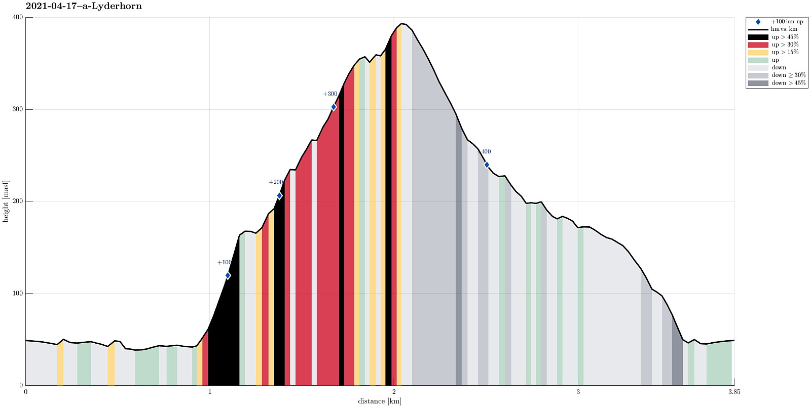
| Distance | 3.9km |
| Vertical meters | 426m |
| GPS |
|
| Ascents | Lyderhorn (396m) | 17.04.2021 |
|---|---|---|
| Visits of other PBEs | Lyderhornhytten (lokalitet) (396m) | 17.04.2021 |
Trip Summary
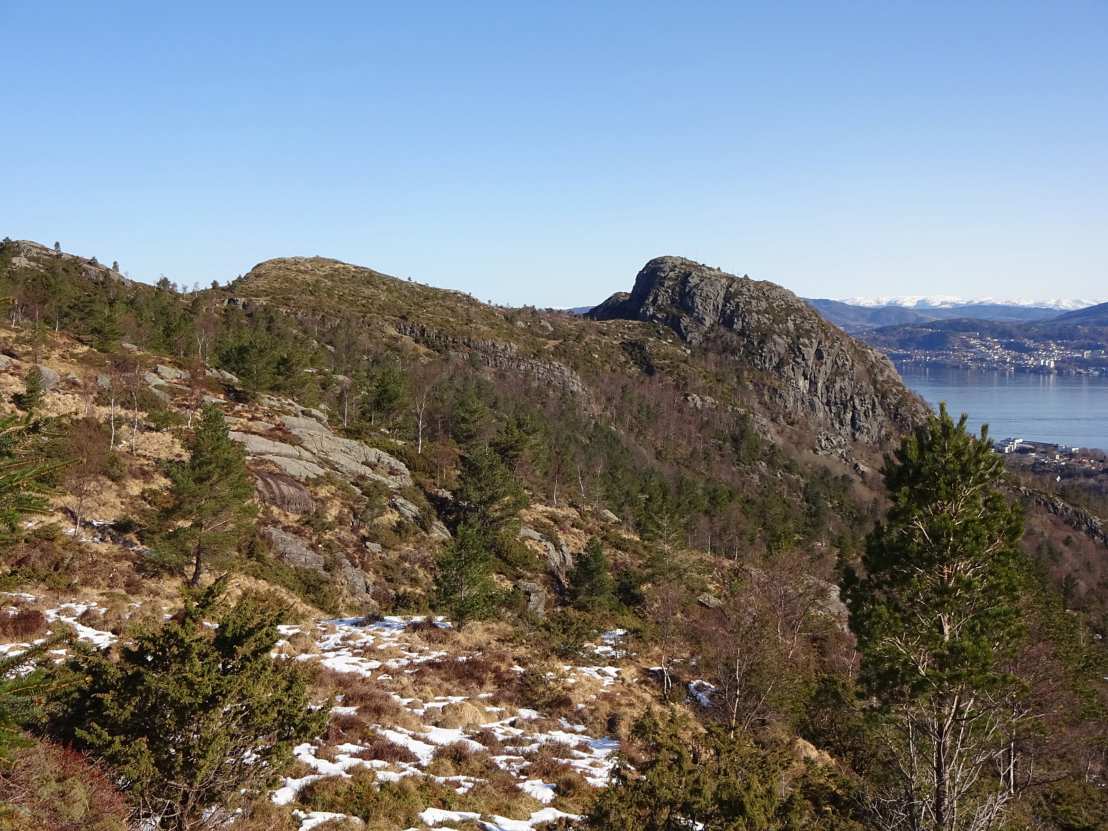
We wished to use the very nice morning for a short hike and decided to try a new ascent to Lyderhorn (via Lia). We parked next to Lyderhornsveien, not far in the southwest of the big highway cross (basically at the saddle in the east of Skarpafjellet). From there, we first walked along Lyderhornsveien (in northeastern direction and parallel to the highway to Bergen) until we came to the lower ends of Lia, i.e., the quite steep eastern side of Lyderhorn (between the top of Lyderhorn and Liavatnet on the other side of the highway). On the map, it had looked as if it should be possible to ascend up to Lyderhorn via Lia, starting in northwestern direction first (just west of a little stream that is marked on the map) until one arrives at the a little less steep slopes that connect the top of Lyderhorn with Lianakken further down. At large, this was also confirmed (as this was the route we took up): it's steep, yes (at times, we used our hands, also, to get up some steeper section), but clearly doable without major difficulties when choosing an appropriate line. Following this route in wet/icy weather, however, is maybe not necessary. Enjoying the sun and good weather, we soon arrived at the higher grounds of Lyderhorn. Before getting to the very top, we had a short break at a minor sub-top (maybe 150m east of Lyderhorn's top) with great views mostly in eastern direction. From Lyderhorn, we then followed one of the trails down (into the direction of Skarpafjellet). Before actually getting to Skarpafjellet, we turned left (eastwards) at the saddle before Skarpafjellet and followed the trail down to the highway cross from there. All in all, this was a nice little alternative, including a bit of an adventure feeling (ascent via Lia), and we returned very satisfied.
Photos
Selected photos are available as Google photo album.
Useful Resources
See also the related FB-page Hiking around Bergen, Norway.
Web page WestCoastPeaks.com provides useful information about Lyderhorn and Ørnafjellet
and also Petter Bjørstad has a page about Lyderhorn.
On Bergentopp 200 there is a page (in Norwegian) about Lyderhorn.


User comments