
Tellevikafjellet and Nordgardsfjellet (11.04.2021)

Written by HHauser (Helwig Hauser)

| Start point | Tellevik (30m) |
|---|---|
| Endpoint | Tellevik (30m) |
| Characteristic | Hike |
| Duration | 3h 30min |
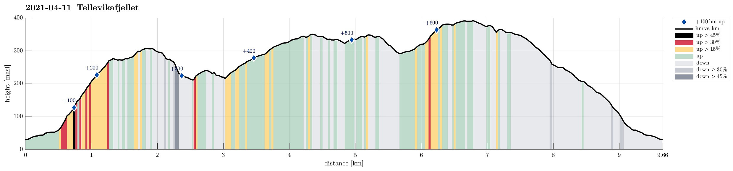
| Distance | 9.7km |
| Vertical meters | 656m |
| GPS |
|
| Ascents | Nordgardsfjellet (355m) | 11.04.2021 |
|---|---|---|
| Tellevikafjellet (395m) | 11.04.2021 | |
| Visits of other PBEs | Milastemma (211m) | 11.04.2021 |
| Nornabakken (360m) | 11.04.2021 |
Trip Summary
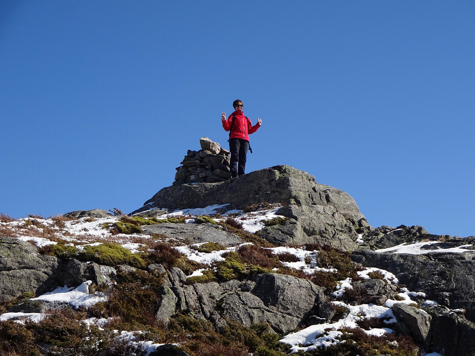
With the perspective of a nice winter day ahead of us, we decided to try something new (again). According to some exchange with friends not long ago, we planned to walk up Tellevikafjellet from the north, i.e., from Tellevik. We took the car from Bergen towards the north (along E39), following the main road towards Norhordlandsbrua. At the last exit before the bridge, where one can leave towards Hordvik (in the northeast) or Salhus (in the southwest), we left E39 and parked basically at the first convenient opportunity to do so, right next to the roundabout underneath the main road. From there, we then followed a simple forest road, which extends parallel to E39 on its northeastern side, until we came to a passage under E39 that we used to get to the other side (Tellevikafjellet is on the southwestern side of E39). On the other side of E39, we first turned right (into northwestern direction), but only to find a suitable spot for turning left, again, and starting the actual ascent there (to follow the trail that leads up there, one probably should just continue in southwestern direction after the passage under E39). Stepping up through the forest was still no problem at all (a bit steep, but nicely possible). After some 50hm off-trail through the forest, though, we connected with the trail and continued on it from there. Shortly after, we got to the norther ridge of Tellevikafjellet, and also left the forest behind us. Once about 200mosl, or so, we started to enjoy some nice views, mostly in northern direction, across Salhusfjorden, towards Meland, Flatøy, and Lindås. As soon as the terrain became a little less steep, we started to see for opportunities to deviate from the trail (our goal was to end up at Milastemma). This brought us to some other very nice look-out points with excellent views (mostly towards the north). Nice! From there, we then continued (without trail) in southern direction, aiming carefully at those parts of the western slopes of Tellevikafjellet that are not all too steep (some are). We also knew that it should be possible to connect to another trail, this way, that connects Tellevikafjellet and Milastemma. Instead doing so, however, we found a reasonably fine opportunity to descend also without a trail (one needs to find such opportunities there, however, since some parts are too steep for simple hiking). Shortly later, we arrived at Milastemma, which really is worth a visit (at least on this nice winter day, with ice on the water and nice sun in the sky). On the other, western side, we then followed a trail that winds around Geithaugane, eventually leading up to Litle Jørgenstemma. From there, it was then quick across a nice ridge (in the east of Litle Jørgenstemma) up to Nordgardsfjellet. Also this top offers really nice views (in all directions, actually)! After exploring the upper parts of Nordgardsfjellet a little, also enjoying some nice views over Byfjorden in the west, we continued into the direction of Tellevikafjellet (across Salhusskaret). Sharing this trail with quite a few others, we quickly connected (back) to Tellevikafjellet, enjoying a nice little break in the sun on its southern ridge. We then continued northwards (and across the top of Tellevikafjellet, which isn't that clear to see; it's more that one could accept several spots as tops up there), following the main trail, first. Where this main trail, however, turns back (into southeastern direction and down towards Nonsteinen), we continued in northern direction (now without a trail, at least none to see, and through moderately deep snow). This brought us first to Nornabakken/Bjørndalsbakken, where apparently some 80 years ago lots of ski jumping happened. After stepping through some more snow from there (still in northern direction), we made it to the other northern ridge of Tellevikafjellet (in the east of Bjørndalen). There, we followed some foot steps in the snow (further down in northern direction), until they turned right and into the forest (a bit above Nysetra). In the forest, it then became clear that we had connected to a marked trail, which we then followed down until we came to a slightly more open area in the west of Kråkenebben (but still on the western side of the little stream down there). Staying on this side of the stream (and Elvagjelet), we followed another (nice) trail further down (now in northern direction, again). This brought us back to the spot, where one can cross underneath E39 (from where we simply walked back as we had come there in the beginning). Altother, this was a nice hike in wonderful winter weather (nice snow, nice sun!). In parts, we proceeded without any trail (and partly, also, through somewhat steep terrain); all without major difficulties, however, and enjoying ourselves quite a bit! :-)
Photos
Selected photos are available as Google photo album.
Useful Resources
See also the related FB-page Hiking around Bergen, Norway.
Web page WestCoastPeaks.com provides useful information about Håstefjellet (Høgstefjellet), Tellevikafjellet, and Nordgardsfjellet.


User comments