
Herlandsfjellet, Skåldalsfjellet, and Skåldalsnipa (03.01.2021)

Skrevet av HHauser (Helwig Hauser)

| Startsted | Osavatnet parking (310moh) |
|---|---|
| Sluttsted | Gullfjellsvegen (200moh) |
| Turtype | Fottur |
| Turlengde | 4t 30min |
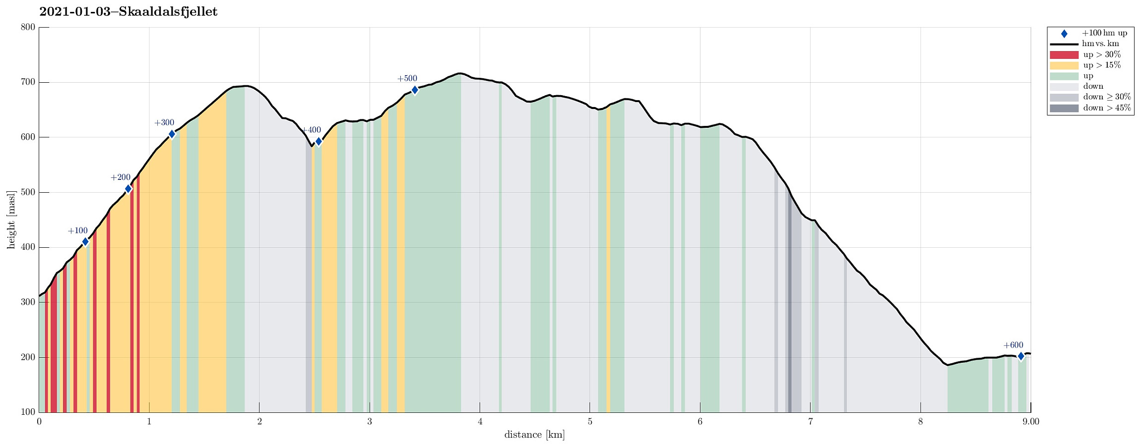
| Distanse | 9,0km |
| Høydemeter | 606m |
| GPS |
|
| Bestigninger | Grøna (680moh) | 03.01.2021 |
|---|---|---|
| Herlandsfjellet (695moh) | 03.01.2021 | |
| Skåldalsfjellet (718moh) | 03.01.2021 | |
| Skåldalsnipa (603moh) | 03.01.2021 | |
| Andre besøkte PBE'er | Torvhus Sælingane (640moh) | 03.01.2021 |

Trip Summary
This Sunday was predicted to come with blue skies and nice winter weather, and so it was! The day before we had arranged for a joint hike up Skåldalsfjellet to catch a good amount of winter sun, while also having some good time in not too deep snow. In order to cross over Skåldalsfjellet (from northeast to southwest), we started at the north-side of Osavatnet, almost at the very end of Gullfjellsvegen, where many of those, who venture into th Gullfjellet-mountains, park and start. Instead of walking towards Gullfjellet, however, we turned towards Ormarinden, a nice ridge that comes down from Herlandsfjellet in the north of Osavatnet. This ridge has a very nice trail on it, making the ascent to Herlandsfjellet straight-forward and non-difficult. At the very top of Herlandsfjellet, we then aimed for Minneskardet to cross over to Skåldalsfjellet. This is all quite easy and straight-forward with the one small point that its quite a bit steep right at the saddle (on both sides, i.e., towards Herlandsfjellet and towards Minnehaugen). So instead of challenging us more than necessary, we walked around the actual saddle in its north, crossing over to Faularinden, i.e., the northern ridge of Minnehaugen, there. Once back up on the ridge (Faularinden), the continuation was again (relatively) easy (stepping through the fresh snow, however, required a little bit more effort than following the already used trail up Herlandsfjellet). Crossing Minnehaugen and then Småskaret, where we also crossed the impressive stone wall that seems to be there already for a longer while, we eventually made it up to the smooth heights of Skåldalsfjellet. At the very top of Skåldalsfjellet, we enjoyed a brief break as well as the nice views in all directions. From Skåldalsfjellet, we then first walked to Grøna (in the southwest), looking down into Djupedalen from there, before turning back north to connect to Sælinga without descending first all the way down into the valley in the west of Grøna. Also from Sælinga we enjoyed the nice views before then descending to Skåldalsnipa, including also the nice, big cairn in the north of it from which one can look down to Arna. From Skåldalsnipa, we then descended via Storerinden (and the quite a bit used trail on it) to gravel road Moldamyrane, which extends "parallel" to Skåldalselva all the way down in the valley. Once there, we just walked back along this road to Gullfjellsvegen. All in all, this really was a very nice hike through snow and sun -- nice! :-)
Photos
Selected photos are available as Google photo album.
Useful Resources
See also the related FB-page Hiking around Bergen, Norway.
Petter Bjørstad has a useful page about Skåldalsfjellet and also web page WestCoastPeaks.com provides useful information about Skåldalsfjellet, Herlandsfjellet, Repparåsen (Tunesfjellet), and Arnanipa.
Web page UT.no from the Norwegian Trekking Association recommends a hike up to Skåldalsnipa.


Kommentarer