
Livarden via Nordvardsrinden (15.11.2020)

Skrevet av HHauser (Helwig Hauser)

| Startsted | Unnelandsvegen (75moh) |
|---|---|
| Sluttsted | Unnelandsvegen (75moh) |
| Turtype | Fottur |
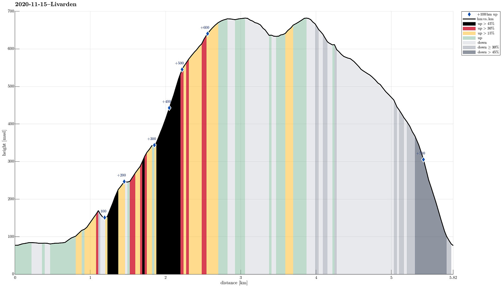
| Turlengde | 4t 00min |
| Distanse | 5,8km |
| Høydemeter | 698m |
| GPS |
|
| Bestigninger | Livarden (683moh) | 15.11.2020 |
|---|---|---|
| Andre besøkte PBE'er | Livarden Bautastein (635moh) | 15.11.2020 |
| Stallafossen (195moh) | 15.11.2020 | |
| Unnelandsvegen parkering (75moh) | 15.11.2020 |
Trip Summary
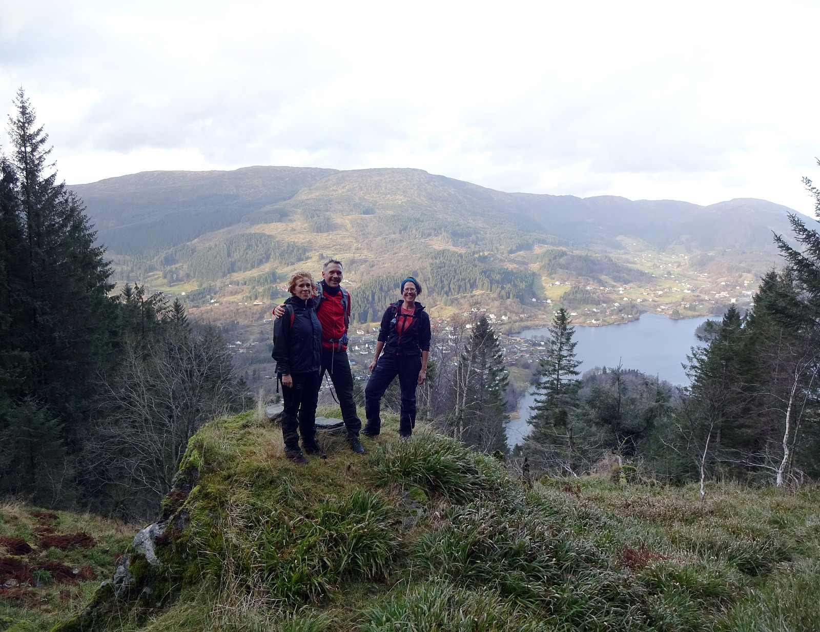
Lucky we have friends, who agreed to embark with us on a little adventure: ascending to Livarden from Unnelandsvegen! To prepare, we had carefully studied the map and, in particular, the area between Kalvehalsen and Nordvardsrinden. A search for related trip reports of others did not result in anything. Understanding that the terrain is very steep on the north-side of Livarden, we paid extra attention to where we possibly could do it. Eventually, we decided to first approach Stallafossen (to have a look at it), then traverse to a little cabin at about 250mosl, west of Stallafossen, before then ascending along Nordvardsrinden up to Livarden. We parked along Unnelandsvegen, where the trail over Lavrinden comes down (where Klubbaelva spings into Nygardvika), and walked along Unnelandsvegen to Li (just a few hundred meters on the road). At house number 225, we then turned right, following first a simple forest road that extends southwards (and diagonally upwards along the steep northwestern side of Rambjørga). Staying first on the eastern side of the little stream that comes down from Stallafossen, we ascended (easily) towards a point at about 175mosl. From there, we (a) saw (a bit of) Stallafossen and (b) did not really see any way of proceeding further (without unwanted challenges). Since seeing Stallafossen was not completely unobstructed from this point (a couple of trees etc. in between), it remains a question whether one could in fact approach it even better on the west-side of the stream. To cross the stream, we decided to descend first a bit further down (the stream is kind of deeply cut into the mountain side directly north of Stallafossen), finding a suitable place maybe 40 meters further down. From there, we then continued towards this cabin at about 250mosl, following a "diagonal route" in southwestern direction. After crossing a simple fence and at about 200mosl, we got to use a simple trail that leads up to the cabin. This cabin, sitting beautifully on a "nose", is a good check-point, in fact. From there, it's then "straight forward", following first a simple ridge (free of trees, there, also!) in southern direction. When crossing 300mosl (approximately), one starts to see a nice, little valley in the east of Nordvardsrinden that extends steeply (yes, steeply) up in southwestern direction. Nordvardsrinden, in the west of this valley, is covered with grass and makes a pretty smooth appearance (at least from a distance). In fact, it is indeed quite well-suited for stepping up the steep mountain side there, while one of course needs to be cautious due to the steep terrain. Also, if you're not used to stepping up steeply (without a trail), then you should maybe try out such a "direttissima approach" somewhere else first. To our honest surprise, we "bumped" into the cabin owners on this very ridge as they were coming down, probably to see after their cabin! :-) After a short chat, we continued upwards long Nordvardsrinden. Once crossing 550mosl, approximately, this ridge "flattens out" a little and hiking becomes a lot easier. We then continued further up and crossed Nordvarden before getting to the big cairn at Livarden. Due to strong winds on the top of Livarden, we then decided to have our little energy refill break at Krokvatnet, just about 50 heights meters below the top (in southeastern direction). There, we enjoyed the nice place, also taking a new look at the large Bautasteinen. To get back, we crossed over the top of Livarden once again, but just to descend, again, on the other, western side. There, it's quite steep, but descending over the grass is no big deal (and there's a trail, also). A little above 600mosl, we then connected to Lavrinden (with its trail). Following Lavrinden down (in northern direction) is first nice and easy and one can enjoy good views from there. Below (about) 500mosl, however, the ridge becomes quite a bit steeper. While the trail across Lavrinden continues all the way down, it's unfortunately very slippery (and steep). This does not make it exactly easy to descend there (it might, in fact, be easier without a trail!). Carefully stepping down, we then connected to another trail, at about 250mosl, that comes down from Seterhaugen in the valley west of Lavrinden, leaving this valley before the valley continues into Mørkgjelet. From there, it's then straight-forward to continue further down, west of Klubbaelva, and back to Unnelandsvegen. All in all, this route is a highly interesting and rewarding alternative ascent to Livarden. It's really steep, but well-doable (if you're a somewhat experienced hiker, who's not scared to step up steeply off-trail).
Photos
Selected photos are available as Google photo album.
Useful Resources
See also the related FB-page Hiking around Bergen, Norway.
Petter Bjørstad has a useful page about Livarden and also web page WestCoastPeaks.com provides useful information about Livarden.
Web page UT.no from the Norwegian Trekking Association recommends a much easier hike to Livarden (from Totland).


Kommentarer