
Gullfjelltoppen via Gulltjørna and Storegga (18.10.2020)

Geschrieben von HHauser (Helwig Hauser)

| Startpunkt | Hardangervegen (265m) |
|---|---|
| Endpunkt | Hardangervegen (265m) |
| Tourcharakter | Wanderung |
| Tourlänge | 6h 00min |
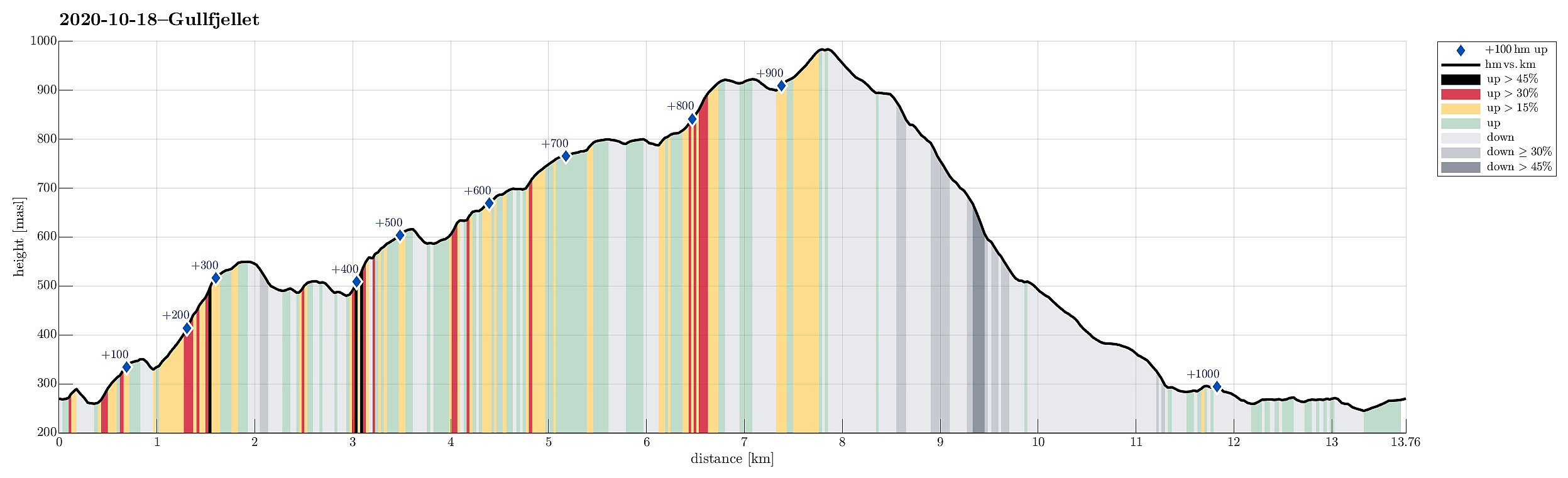
| Entfernung | 13,8km |
| Höhenmeter | 1.056m |
| GPS |
|
| Besteigungen | Gullfjelltoppen (987m) | 18.10.2020 |
|---|---|---|
| Storegga (926m) | 18.10.2020 | |
| Øst for Vossavardane (803m) | 18.10.2020 | |
| Besuche anderer PBE | Gullbotn p-plass (244m) | 18.10.2020 |
Trip Summary
We looked forward to a cold but sunny autumn Sunday and thus planned a hike "with high expectations"! :-) While we had earlier hiked quite a bit "here and there" in the Gullfjellet area, we not yet had traversed Storegga (in the north of Gullfjelltoppen). Thus we had a plan! :-) To make this hike a nice round, we aimed to start at the saddle between Trengereiddalen and Gullbotn, then traverse (without a trail) to Gulltjørna, before then ascending Gråfjellet and from there Storegga. After that, our plan was to hike down the major trail between Gullfjelltoppen and Gullbotn.
To Gulltjørna from Hardangervegen
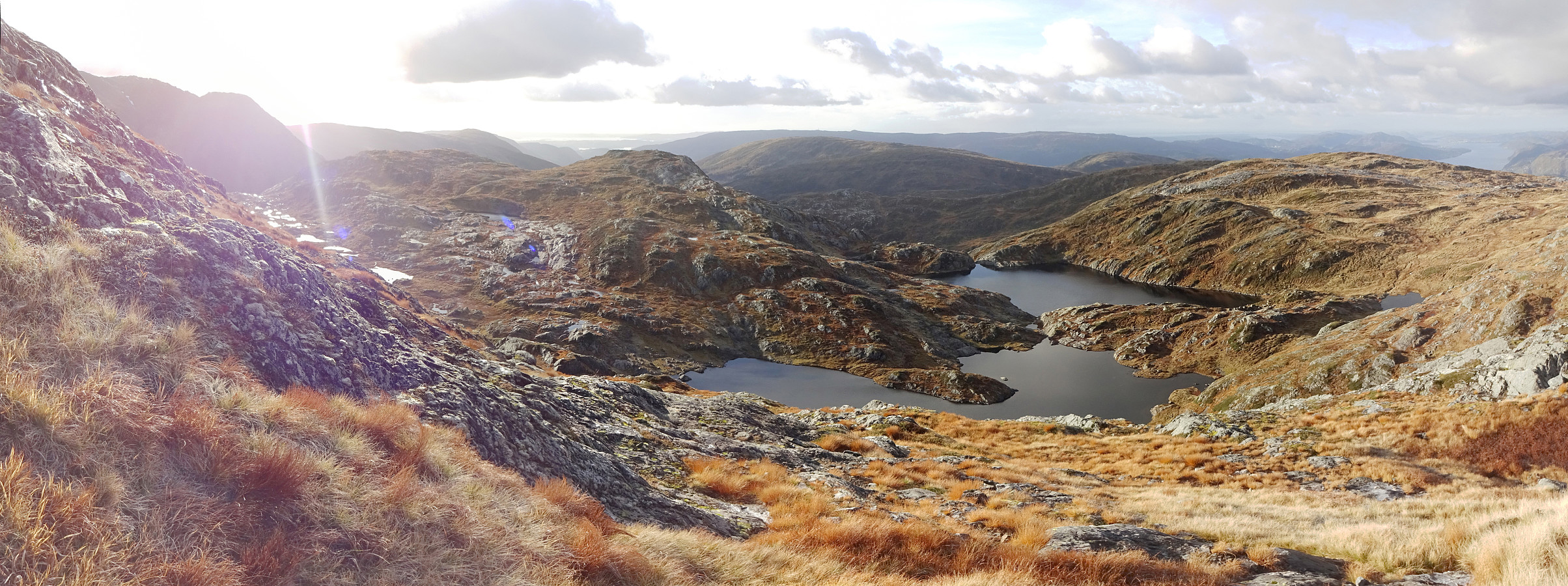
We left Bergen to the East, following E16 from Arna until the roundabout near Trengereid, where we turned right (in southern direction). We then drove up Trengereiddalen until we came to the saddle between Svartliåsen in the northeast and Setreåsen in the southwest). Right at the saddle, we found a suitable opportunity for parking our car right next to the street. Still, we had been driving a little further than what we had looked at on the map at home. Instead of walking back along the road, we followed a simple forest road that suggested to bring us further up on Setreåsen right south of where we parked. After a few moments of walking along this forest road, however, we got the impression that it did not lead upwards enough. Thus, we left it in northwestern direction (a bit steep, but no problem), and ascended to the northern ridge of Setreåsen from there (just a couple of height meters). On the other side, we then descended to what seemingly is a skiing track in winter time. After crossing the valley in the west of Setreåsen we came to the very southern end of a nice and inviting ridge, leading up to Rustene. This ridge was nice and straight-forward to hike up, offering also some nice views "back" (in southern and eastern direction). Once near the "top" of Rustene (at about 350mosl), one needs to decide about how to proceed (some parts of the western flanks of this ridge are vertical cliffs). After crossing a little extra-hill in the southwest of Rustene, we found a good spot for descending, again, and crossing over near the saddle in the west of Rustene. From there, it was then up (in southwestern direction), ascending across some pleasant grass slopes. In order to not exactly hike up in all the water that also comes down there, we followed a course that ascended a little steeper (on the western side of this little valley). At about 500mosl, we then arrived at the next ridge, leading further upwards (now in north-/northwestern direction). Up there, the terrain is not very steep and thus proceeding is pleasant and easy. Shortly after, we arrived at a little "top" (about 550mosl, in the northeast of Rundtjørna) from where we could nicely look over to Trengereidhotten. For a short moment, we considered to also include Trengereidhotten (not really far), but decided against this idea, prefering a more direct course towards Gulltjørna. We thus changed to a more southwestern direction, descending (first kind of steeply) into the direction of Rundtjørna. We then passed by Rundtjørna in its north, and connected to the place in the very north of Langatjørna, where it "empties" towards the north (and Risnestjørnane). We continued into the direction of Timbertjørna, enjoying some nice views down onto this little lake from its quite steep eastern side. From there, we talked first a bit southwards in order to pass by Timbertjørna in its south, getting into the valley that connects Risnestjørna in the south and Risnesdalen in the north. On the western side of this valley, where Steinfjellet stands with some pronounced cliffs in its northeast, one can find a convenient slope for the ascent towards Gulltjørna (rounding Steinfjellet in its north). This ascent is quite steep, to begin with, but nicely doable and no problem at all. Once at about 550mosl, again, the terrain flattens out a bit, again, making the continued ascent towards Gulltjørna a nice and enjoyable experience! While one can get to Gulltjørna by simply crossing over a little saddle in its northeast, we this time decided to approach Gulltjørna via the little hill right in the east of Orfallet. Walking over these (minimal) heights, however, provides one with a really nice view onto Gulltjørna! :-)
Via Storegga to Gullfjelltoppen
Once we descended to Orfallet, and having crossed it, we continued in northwestern direction in order to get up the northern ridge of Gråfjellet (standing impressingly in the west of Gulltjørna). This ascent is really nice and easy and one can choose the steepness according to one's own liking. After arriving on the ridge (and enjoying the really impressive view down into Romslabotn!), we turned left (in southwestern/southern direction) and continued up along the ridge. At about 775mosl, in the southwest of (and high above) Gulltjørna, one meets a rather pronounced cliff. While the map had suggested that walking around it (on its north) and ascending from there in southern direction seems best, we spotted a fine opportunity "in the middle of the cliff", ascending over some steep grass there (nicely doable!). Once on top there, the terrain flattens out, again, and proceeding further is enjoyable and easy. After crossing over a little micro-top there, we approached another northwest-facing cliff (the "starting point of the ascent to Storegga"). Conveniently, however, it is also there that a trail comes up with Tjørnane (and Tjørndalen further down), provding a nicely marked opportunity to get up there! :-) Following a series of small cairns, we quickly made it up to Storegga, enjoying some nice views across Tjørnane and Litlegullfjellet. Crossing over Storegga, one cannot avoid being impressed by the view of then already near Gullfjelltoppen. From Storegga, actually, its steep northwestern flank is well visible! The saddle between Storegga and Gullfjelltoppen is "marked" by a relatively large lake and passing by it on its northern side is most convenient. This also brings one to the major trail that connects Gullbotn further down and Gullfjelltoppen not far from there. Even though our original thought had been to descend from there to Gullbotn, we could not resist and included Gullfjelltoppen, also (just about 10 additional minutes from the saddle). Arriving on the top of Gullfjelltoppen then provided the first wintery impression of the year (with the rocks being frozen over). Thanks to the good weather, we could also enjoy some really nice (and far!) views!
Back down via to Gullbotn
From Gullfjelltoppen, we then followed the major trail downwards into the direction of Gullbotn. At times, we had to watch out a little (due to icy rocks), but all-in-all this trail is easy to find (in good weather). At about 510mosl, where the trail arrives at upper Gullbotn (and where some rescue material is also placed), we enjoyed a short break, eating a little snack. We then continued towards Nedre Gullstølen, "enjoying" the pretty muddy trail. Staying on the southern side of the stream, we continued along the main trail further downwards until we joined this "skiing track", again (now further south). Using the good bridge of this track, we crosed the stream and started walking along this track in order to get back. Indeed we quickly arrived at the very spot, where we already had used this track (just for a few meters in the beginning). Since we were not exactly keen on traversing the non-negligible vegetation on Setreåsen, again, we thought that continuing a bit further south along the track would sure connect us to some proper trail across Setreåsen. Well, well! :-) Eventually, we walked all the way back to Gullbotn (not that far, but still), before we found a connection back to the road. This way, we needed to walk back to our car along this quite heavily usd road, which was not the most pleasant experience to end this hike with. After all, however, it could not overshadow all the amazingly positive impressions that we had collected (especially from our way up via Gulltjørna!). Clearly a really nice hike on a wonderfully nice autumn/winter day!
Photos
Selected photos are available as Google photo album.
Useful Resources
See also the related FB-page Hiking around Bergen, Norway.
Petter Bjørstad has a useful page about Gullfjellet and also web page WestCoastPeaks.com provides useful information about Gullfjellstoppen, Litlagullfjellet, and Gullfjellet.
Web page UT.no from the Norwegian Trekking Association recommends to follow the main trail from Gullbotn up to Gullfjelltoppen.


Benutzerkommentare