
Krånipa, Raudnipa, and Hananipa (from Gullbotn) (19.09.2020)

Written by HHauser (Helwig Hauser)

| Start point | Gullbotn (245m) |
|---|---|
| Endpoint | Gullbotn (245m) |
| Characteristic | Hike |
| Duration | 7h 30min |
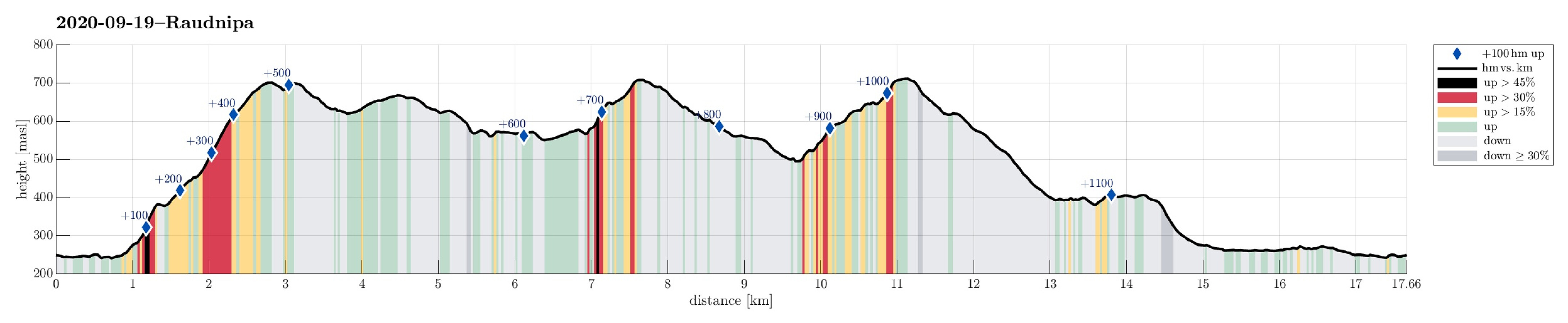
| Distance | 17.7km |
| Vertical meters | 1,173m |
| GPS |
|
| Ascents | Hananipa (717m) | 19.09.2020 |
|---|---|---|
| Krånipa (707m) | 19.09.2020 | |
| Krånipa NV (703m) | 19.09.2020 | |
| Raudfjell (671m) | 19.09.2020 | |
| Raudnipa (711m) | 19.09.2020 | |
| Skåpet (385m) | 19.09.2020 | |
| Visits of other PBEs | Gullbotn p-plass (244m) | 19.09.2020 |
Trip Summary
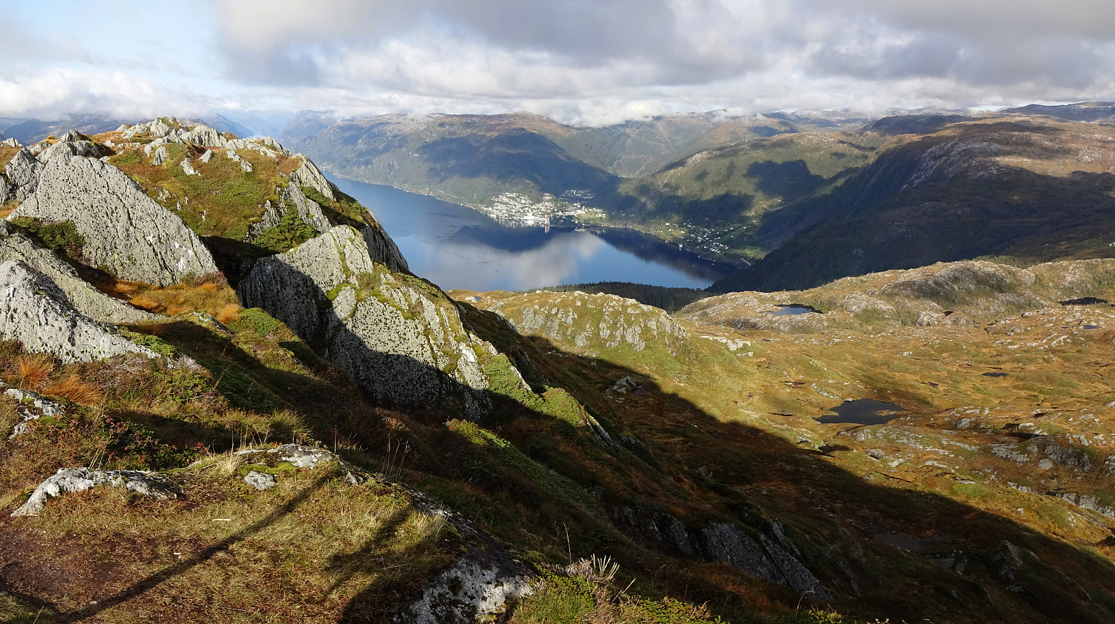
After a quite rainy period, we looked forward to a weekend with some nice weather. After weighing several hiking ideas against each other, we settled on a slightly longer hike over three Nipa-mountains in the East of Gullbotn. Driving along E16 from Arna, we turned right and up towards Gullbotn near Trengereid. Once above the saddle, we left the road at Gullbotn and parked right there (quite a number of parking places there). According to our plan (Krånipa first), we first headed in northern direction to get around Øyjordsvatnet. Almost exactly where Teinelva enters Øyjordsvatnet, we used a convenient bridge for pedestrians to get over to the other, eastern side. There, we turned left, again, to head for a small valley that runs south-north in the west of Skåpet. While passing by the last house (or cabin), we were friendly instructed to turn right immediately after passing by the house on its western side. This brought us up to the valley that we were heading to. Maybe about half way up through this little valley, we decided that we could equally well ascend to Skåpet "direttissima" (instead of following the valley up to the saddle and then turning left and "back" again). The western side of Skåpet is steep but straight-forward to ascend. Once at Skåpet, we headed over to the southwestern side of Krånipa, ascending it in northeastern direction. Occasionally, we had the impression that we were at (or crossing) some trail, but altogether it appeared to us that there simply was not much of a trail. Most of this ascent was also easy and straight-forward, especially the upper parts. Between 450mosl and about 500mosl, we had to get through a bit more vegetation than fully pleasant, but all in all, this ascent was nice and straight-forward. Approximately 75 minutes into our hike, we arrived at Krånipa, enjoying some very nice views in all directions. Our next goal, then, was Raudfjellet (in the south of Holmavatnet). To get there, one needs to get down from Krånipa (on its eastern side), which is not 100% simple as Krånipa is very steep in this side (it is roughly 100 meters higher than Våghalsgjelet that lies "directly below" it on its eastern side). A few hundred meters further south, however, it's possible to descend (across two "steps") and get over to the southwestern side of Raudfjellet. The ascent to the "top" of Raudfjellet is then easy and straight-forward. From Raudfjellet, we had the plan to surround Holmavatnet in its south and east, before then heading north towards Raudnipa. The eastern side of Raudfjellet, however, it quite a bit rigged, with some pronounced "lines" running (approximately) north-south across it. At several points along this route, we had to carefully descend over relatively steep terrain (and without any trail). About half way to the east of Holmavatnet, we used one of these "cuts" and descneded all the way down to Holmavatnet, refreshing ourselves briefly there. Similarly to an earlier occasion, also this time, Holmavatnet proved to be challenging to surroung. At several spots, the hillside on its south fall into the lake relatively steeply and make it basically impossible to get around the lake at the water level. We thus walked back up "the cut" and traversed along the lake then "half way up the hillside". There, we found it relatively easy to proceed eastwards. Soon after, we found ourselves on the ridge which separates Holmavatnet (in the west) and Raudvatnet further below (in the east). From the original study of the map (at home), we had expected to cross a stream (or the like) running from Holmavatnet down to Raudvatnet, but no mentionable such stream was to be seen (making this passage easy and straight-forward). North of Raudvatnet, we then connected to a trail, which even is marked with red dots: more than what we had expected! :-) This marked tail leads up to Raudnipa (steep, but straight-forward thanks to the trail!). Soon we had arrived at Raudnipa, enjoying some really nice views (not at the least towards Vaksdal and Sørfjorden) as well as some nice afternoon sun that invited us to break for a slice of bread, or two. Not only knowing, but also feeling that this hike developed into something longer than usual, we pondered a bit about which route to take back to Gullbotn. After a bit of evaluation, we ended up at our original plan, i.e., including Hananipa on the way back. The one thing to consider, when connecting Raudnipa and Hananipa, is that Raudnipa stands a bit off the main ridge line, extending southwards from Vinnskaret (this main ridge leads towards Trollabotsvarden in the west of Raudnipa instead). When crossing Raudnipa from south to north, one gets to Mittfjellt, north of Raudnipa, when not "turning left" consciously at Raudnipa. Once on the (smooth and nice) northern flank of Mittfjellet, however, it's important to cross over to this "main ridge" between Trollbotnleitæ (in the south) and Heiane (in the north). Doing so, we had to cross multiple (small) streams, which all head steeply downwards in the north of Mittfjellet (when aiming for Hananipa, however, one does not wish to descend that much). Once on the "main ridge", again, the continuation is gentle and nice, again (to Heiane). Northwest of Heiane, however, one needs a bit of proper orientation, again. The goal is to cross Vinnskaret (below and in the east of a little hill called Middagshaugen), while not descending too much, and to find the "trail" that leads upwards to a saddle northwest of Vinnskaret. Once there, the continuation is again easy to find (across the ridge towards Hananipa, one enjoys not only marvelous views, but also a trail). In the very east of Hananipa, then, it again becomes a little unobvious (and quite a bit steep). Still, it's only a few steps before one is up at the ridge across Hananipa. There, then, one finds a major trail (at least one), leading over Hananipa and down towards Skulstadvatnet (and Northern Skulstad). Here, as one easily sees, many hikers use to go up and down. At Skulstad, we crossed over right beneath the dam, and aimed at finding a proper trail towards Southern Skulstad. Initially, everything looked nice and easy as we even saw two sign posts, directing us towards our goal. Once at the saddle, however, the whole thing became very unclear, again. Instead of a clear trail towards Souther Skulstad, one finds trails to a variety of cabins up there. But after a bit of back and forth, we eventually found the "proper trail", leading nicely in southern direction from there. Once at Southern Skulstad, we followed the road (in western direction) until it turns right (and into northwestern direction). There, we turned left, taking a trail that heads towards Gullbotn across a protected moor area (Kråmyrane). Following this trail southwards, we found it much less wet than expected and enjoyed crossing through this protected nature reserve. Near the middle of Midttjørna, however, we ran into a "major issue". While previously, as it still appeared to us, one would have continued across a rope bridge to the southern side of Midttjørna, the remains of this "bridge" were now deeply submerged in the lake. No way to get across there without swimming! We thus headed back and started to surround Midttjørna on its western side. This worked quite well, following minor "trails" near the water line. South of Midttjørna, we then used a trail that extended in southwestern direction (eventually leading across a small saddle to Dyven). Instead of following this trail up to the saddle, we turned left (and southwards), crossing (without any trail) across a wet area west of Lonane. At the southern end of this area, we then connected to a trail, again, which within a few hundred meters brought us back to where we had started some 7 hours earlier. Minutes later we were back at our car and on the way back to Bergen. If you are ready for a somewhat longer hike, this round over three Nipa-mountains is an interesting opportunity. When considering this round, however, one should be aware that a significant portion of this round is without any trail and that selected parts of it are (mildly) challenging. Maybe a good round for somewhat experienced hikers. :-)
Photos
Selected photos are available as Google photo album.
Useful Resources
See also the related FB-page Hiking around Bergen, Norway.
Petter Bjørstad has a useful page about Hananipa (which also links to pages about Raudnipa and Krånipa) and also web page WestCoastPeaks.com provides useful information about Hananipa, Raudnipa, Krånipa, and Raudfjell.
Web page UT.no from the Norwegian Trekking Association recommends a similar hike.


User comments