
Okslevarden (01.08.2020)

Geschrieben von HHauser (Helwig Hauser)

| Startpunkt | Indre Haugsdal (55m) |
|---|---|
| Endpunkt | Indre Haugsdal (55m) |
| Tourcharakter | Wanderung |
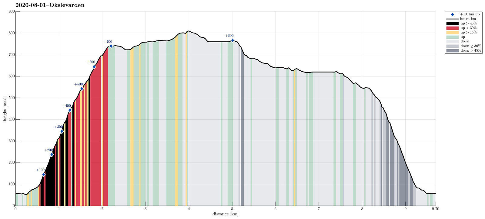
| Tourlänge | 6h 00min |
| Entfernung | 9,7km |
| Höhenmeter | 858m |
| GPS |
|
| Besteigungen | Okslevarden (815m) | 01.08.2020 |
|---|---|---|
| Storebotsnipa (743m) | 01.08.2020 | |
| Besuche anderer PBE | Fjellfossen (455m) | 01.08.2020 |
Trip Summary
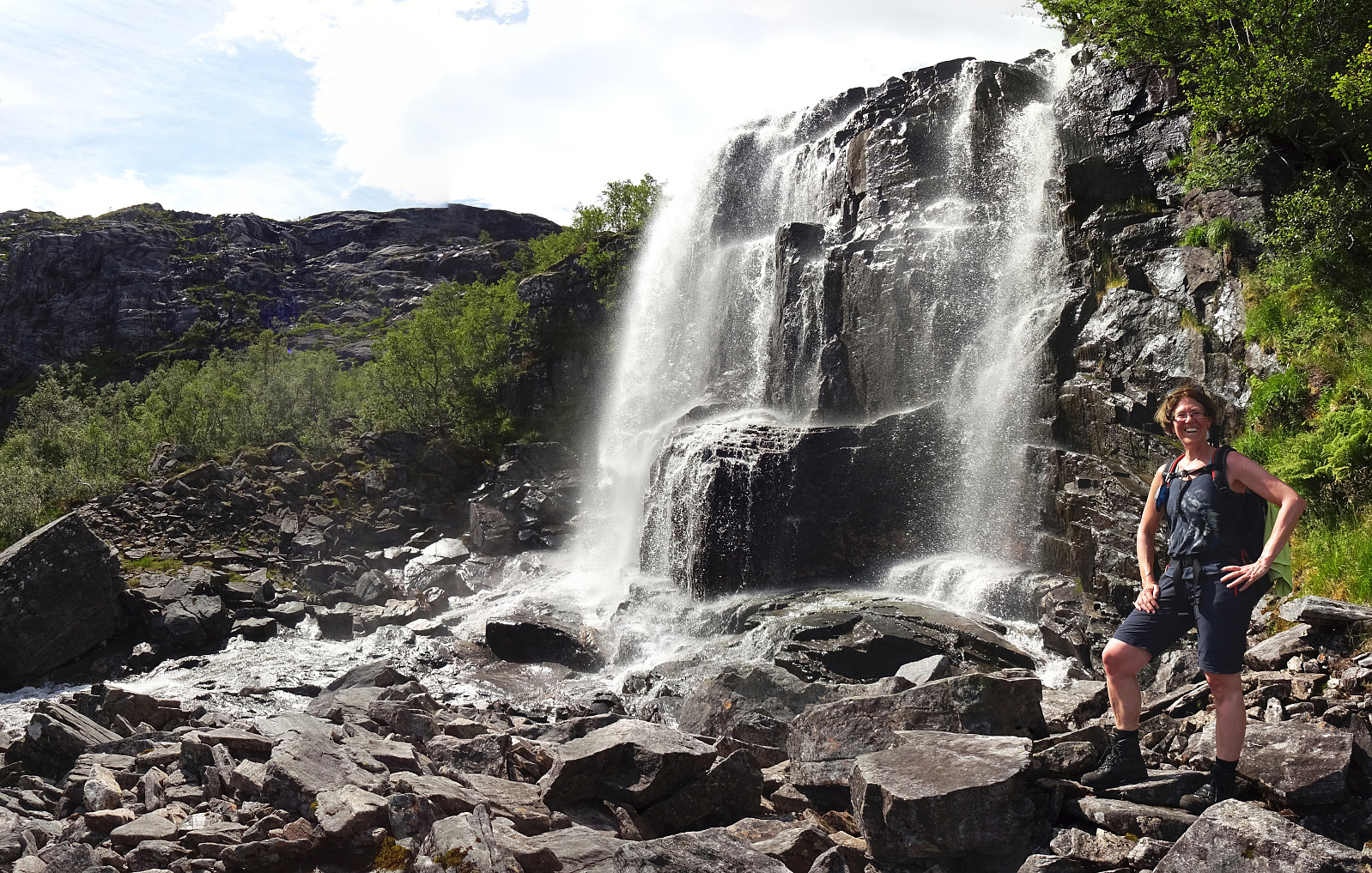
When staying over night in Haugsvær, we were recommended to ascend to Gråsida from Indre Haugsdal. So that's what we did then! :-) We drove road E39 "back" south (into the direction of Bergen) and turned right in Matre (to leave E39 before entering Masfjordtunnelen). This brought us onto the old road and following it we entered Indre Haugsdal from Haugsdalvågen. Driving up this nice valley, we came by three particular hills (in the middle of the valley), which possibly gave the valley its name. Near Kjetland we crossed the river on an old stone bridge, turning right (into the direction of Storemyr) right after the bridge. Since we did not see any particular good parking opportunity next to this narrow road, we drove all the way to Storemyr and asked there. Luckily, we were allowed to leave our car behind right next to their house -- friendly people! We then headed for the starting point of the trail, not finding it right away. Within a few minutes, however, we had found it (a bit further up the hillside than what the map shows -- if one does not descend to the slightly lower terrain beneath the houses, one find the trail right behind the very last building). The first thing to do then was to get to the other side of Kvernhuselva, jumping down from high above (from Haugsdalsvatnet at about 535mosl). Since it wasn't too much water coming down, crossing the stream was straight-forward, following the trail. On the other side, one has to carefully watch out for the trail (at times, it's not really well visible). Still, it's quite straight-forward to follow the (steep!) trail upwards. Especially in the higher section of this ascent it really pays off to use the trail, since some minor cliffs may very well get into one's way. At about 450mosl, we then came to Fjellfossen (a very nice waterfall, part of Kvernhuselva), providing us with an amazing opportunity to refresh ourselves! The continuation is then right north of the waterfall (no need to cross it), even though it's quite a bit steep there. To get up, one also uses some metal stairs, which a good soul has placed there. :-) Then, it's getting a bit more unclear, again. After a bit of more trail, it then somewhat disappears and one needs to find a way to continue. Since we were heading for Storebotsnipa, we followed a northwestern route (quite steep, but OK). It's recommended to carefully read the terrain there as sufficiently high cliffs do limit the choice of directions there. After getting up to about 550mosl, and above the tree line, the situation got clear again. While we had left the trail "for good" (if there is one further below), we could easily find good spots to further ascend (steeply) to Storebotsnipa. Especially after making it up to the eastern ridge of Storebotsnipa, we then found it quite straight-forward to continue to the top. Once on Storebotsnipa, we had arrived on the large plateau of Gråsida. Up there, one has plenty of options for getting around (even though one may still bump into some cliffs, for ex., when coming close to Trolldalen). We then walked over to Okslevarden (via Raudfjellet). Nice hiking up there! :-) On Okslevarden we enjoyed a short break, before starting our hike back (via Trolldalen). In order to get to (and into) Trolldalen), we first walked westwards to get into the saddle north of Trolldalen (nice and easy walking). We then descended southwards into Trolldalen (a bit steep there, but well possible). At about 680mosl, we crossed over the valley to get over to what looked like a nice "middle ridge" in Trolldalen. We then walked southwards on this nice and smooth "middle ridge", coming by Kupevatnet. Further south, we then passed by Trolldalsvatnet before rouding Storebotsnipa in its south. All in all, this Trolldalen is really nice, in particular with all these lovely lakes! Since we expected some (light) rain and wished to descend the steep mountain side in as-dry-as-possible conditions, we headed directly for Fjellfossen (instead of going around Haugsdalsvatnet). The southern flanks of Storebotsnipa are a bit steep, yes, but traversing along them was still nicely possible (just a few places, where some extra care was recommended). With a bit of back and forth, we then also managed to find the trail again, arriving at Fjellfossen just a few minutes later. Descending the same trail down that we had come up, we arrived back down in Indre Haugsdalen (more or less) exactly when the rain started (it started a little earlier than expected though). All in all, this hike up Grådsida (from Indre Haugsdalen) is really nice and offers a number of variants, once one is up on the plateau!
Photos
Selected photos are available as Google photo album.
Useful Resources
See also the related FB-page Hiking around Bergen, Norway.
Web page WestCoastPeaks.com provides useful information about Blåfjellet.


Benutzerkommentare