
Around Hopsdalen (31.07.2020)

Written by HHauser (Helwig Hauser)

| Start point | Haugsvær (60m) |
|---|---|
| Endpoint | Haugsvær (60m) |
| Characteristic | Hike |
| Duration | 8h 30min |
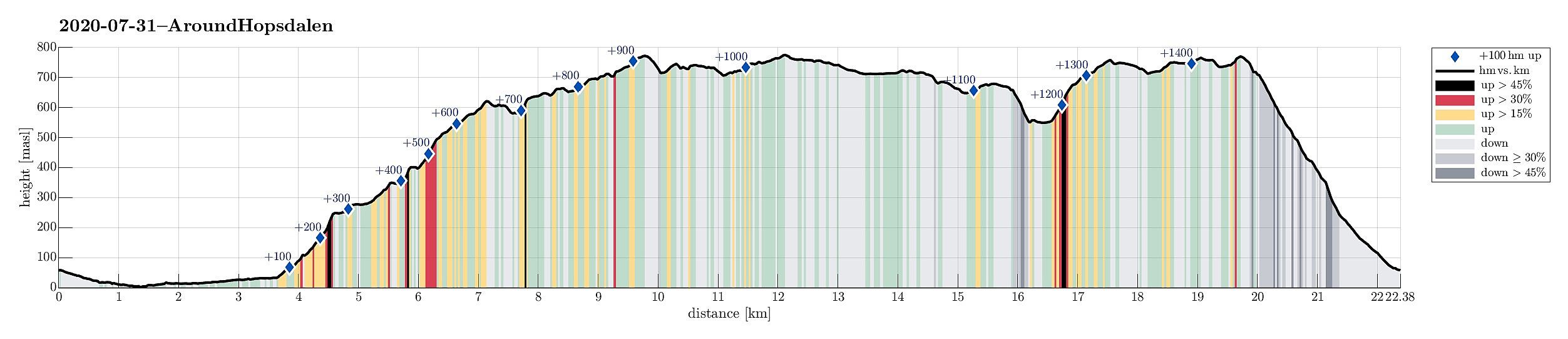
| Distance | 22.4km |
| Vertical meters | 1,459m |
| GPS |
|
| Ascents | Dyrråsklanten (776m) | 31.07.2020 |
|---|---|---|
| Fjellet (774m) | 31.07.2020 | |
| Gavlen (700m) | 31.07.2020 |
Trip Summary
We drove along road E39 from Bergen northwards (into the direction of Masfjorden). After driving down through the long Masfjordtunnelen and passing through Matre at the very end of Matresfjorden, we crossed over to Haugsvær "behind" Nonklettfjellet. Before the main road (E39) disappears into another tunnel, we turned left in Haugsvær and parked right there.
Getting started
Our (slightly ambitious) plan for the afternoon was to go around Hopsdalen (from Høgfjellet via Grønefjellet to Gavlen, and back via Rustefjellet). Considering the steep sides of Hopsdalen, we had looked at the map regarding a possible place for getting up to the top of the surrounding mountains. Near Indre Skjerjehogen, on the north side of Haugsværfjorden, we had thought that it should be possible to reach saddle Sygnegga (between Kjerringefjellet in the southwest and Høgfjellet in the northeast) without any troubles. We thus started to walk along the old road, rounding Vågen at the innermost end of Haugsværfjorden, passing by Vågset shortly after. After about 3.5km on this road (and just shortly after having passed Indre Skjerjehogen), we found the targeted forest road on our right, leading diagonally upwards in western direction.
Up to Høgfjellet
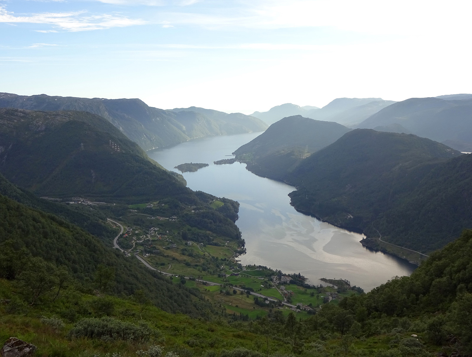
There are several temptations to leave this forest road, turning right, but we resisted them all! :-) At about 160mosl, however, this forest road itself makes a sharp turn, changing to "the other diagonal", now northwards. Shortly after, the forest road ends and one needs to improvise (a little). Stepping up through the forest (it's steep there, but without any problems) to about 240mosl, one can find a trail (not really easy to find and see, but still), marked with blue color every now and then, that leads in eastern/northeastern direction to Sygnegga. Once on the saddle (Sygnegga), the continuation is pleasant and nice, leading gently upwards in northeastern direction. The trail is less clear there (no markers), but it's clear anyway: avoid Glyvra (in the east, cutting deeply across the ridge), find Skarhaugane! Compared to the map, we crossed over Glyvra a little too much south (at about 325mosl, instead of about 350mosl), but continued without any difficulties. Actually, walking up from Betnene to Skarhaugane is really nice! :-) At Skarhaugane, one follows the trail through a nice narrow valley upwards to a small saddle with great views to the north (towards Geirevatnet). The trail leads then in the north around a small top, before continuing further upwards into the direction of Høgfjellet. Once above 500mosl, one really starts to have nice views in different directions (including "back" to the west, and then from Såta at about 550mosl also down into Hopsdalen -- maybe the best vista point for looking eastwards into Hopsdalen along the entire round). Shortly after, one arrives at Høgfjellet, following the ridge. A little north of Høgfjellet, we then saw a nicely placed mountain lake at about 580mosl, where we enjoyed an extended break.
Crossing Dyrråsklanten
After this nice break north of Høgfjellet, we continued eastwards. Passing by Furåsrusta and Smulmeshaugane, we missed the point, where the trail heads southwards (apparently in a rather sharp turn, crossing over Tommeltotten right afterwards). Instead, we crossed the heights and ascended to Dyrråsklanten. Descending from Dyrråsklanten via its steep eastern side (no problem), we reconnected with the trail, leading us further to Grønefjellet. Somewhere between Dyrråsklanten and Grønefjellet, the trail then also became marked (with red "T"s), making it much more obvious where the trail actually is! :-) We then headed further eastwards, passing by Dukefjellet near Dukestølen. Near Dukefjellet, hiking was particularly pleasant, following a very gentle ridge with nice lakes right next to the trail.
Via Gavlen to Stemmevatnet
From our map study, we had expected that we would easily identify the place, where the trail to Gavlen would fork off from the main trail continuing further towards Stordalen in the far east. The map (Norgeskart), however, is slightly inaccurate there: the marked trail leads a bit more north of what is marked on the map. A few meters too far north, we understood the situation, turned back, and started the search for the trail down to Gavlen. This brought us to the edge of a steep hillside, leading down to Nordgjelsvatnet, a nice and big lake in the east of Hopsdalen. The map had suggested a clearly visible, major path, leading down to Gavlen. This, however, does not reflect reality whatsoever. :-) With detailed reading of the hillside, however, it's possible to guess, where previously a trail may have been. This brings one down to a gentle ridge, some 80 meters above Nordgjelsvatnet (in its northwest), leading into the direction of Gavlen (roughly). Loosing the not really existing trail, again, we first headed towards a little height north of Gavlen, offering nice views over Hopsdalen in the west! From there, it was then only a few minutes until we reconnected with the "trail" near Gavlen. Descending from Gavlen to Stemmevatnet is then steep, but well possible. With a bit of searching, one can also find the remains of a trail there (even some stone steps!). Back down at Stemmevatnet, we -- for a moment -- considered to continue further down and into Hopsdalen. Instead, we decided to stick to our original plan and return via Rustefjellet.
Back via Rustefjellet
Even though we recognized that we had walked for some 6 hours, already, we still chose to ascent to Rustefjellet "direttissima", right in the west of Stemmevatnet, following a nice (and steep) ridge upwards there. This ascent offers additional nice views across Hopsdalen (now in the north). After enjoying the views from the highest point on that ridge (762mosl), we headed southwards across the very nice heights of Rustefjellet. This brought us over to the "acutal ridge" of Rustefjellet. Walking across the heights there, we approached Fjellet (Hestafjellet) as a nice high end of our hike! This mountain is probably an appreciated hiking (running?) opportunity for the people in Haugsvær (and nearby), offering great views (mostly towards the west, but also towards Stølsheimen in the far east). The final descent (back down to Haugsvær) was then along a very nice trail (with lots of impressive stone steps in the upper section!). This trail is steep, but really no problem to walk down (or up). Back down in Haugsvær, we found ourselves highly satisfied with this (long) hike (and a bit tired, also). Really a great day!
Photos
Selected photos are available as Google photo album.
Useful Resources
See also the related FB-page Hiking around Bergen, Norway.
Web page WestCoastPeaks.com provides useful information about Rustefjellet (Hestafjellet, Fjellet) and Dukefjellet.


User comments