
Herlandsfjellet from Herland (10.05.2020)

Written by HHauser (Helwig Hauser)

| Start point | Herland (40m) |
|---|---|
| Endpoint | Herland (40m) |
| Characteristic | Hike |
| Duration | 3h 45min |
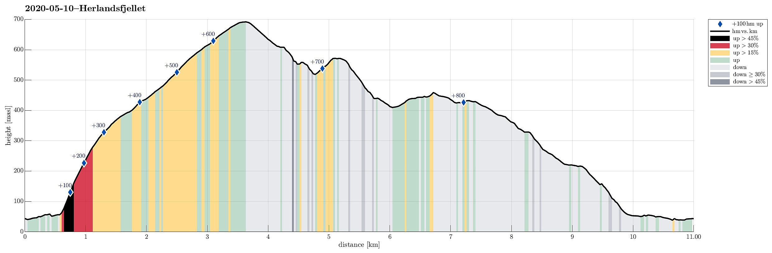
| Distance | 11.0km |
| Vertical meters | 838m |
| GPS |
|
| Ascents | Herlandsfjellet (695m) | 10.05.2020 |
|---|---|---|
| Nordnuken (574m) | 10.05.2020 |
Trip Summary
For a longer time already, we had the idea to try Herlandsfjellet from its northern side. When studying the available maps, it's not so obvious, how this should be done (as no trails are to be seen from the north). After some investigation, we were left with two choices that we deemed possible: going up from Ytre Songstad (along a narrow ridge that is very steep on either side) or going up from Herland, where the bridge to Osterøy is anchored (a less pronounced while also steep ridge). Eventually, looking at satellite images suggested that the eastern variant (from Ytre Songstad) would be through a dense looking forest, while the western variant (from Herland) appeared to have less dense standing trees. Since we were unsure how difficult it would be to ascend through a relatively dense forest, we decided to ascend from Herland.
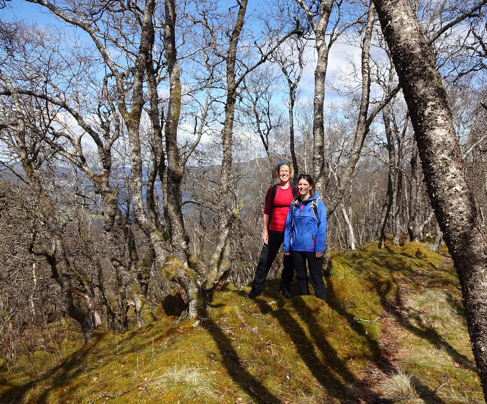
Herlandfjellet form Herland
We drove from Bergen along E16, leaving it where it says "Takvam". We then followed the old road until we came to the bridge (to Osterøy). Right there, basically under the bridge, we parked conveniently next to the road and started our hike. After first getting back to the southern side of the main road (E16), we followed a short gravel road that rounds the lower part of "our" ridge. This brought us quite a bit towards the eastern side of the ridge. There, we then started our actual ascent to Herlandsfjellet. Hiking straight up (quite a bit steep there!), we found our choice just right: without any difficulties we could step up between the trees, walking over pleasant grass cover and having enough place between the trees -- a perfect opportunity to get up there! After a short, but steep ascent to about 450mosl (from about 50mosl), we found the surrounding even better (with the forest kind of opening up). From about 500mosl, then, we continued outside of the forest (following Saurinden further towards the top). Up there, we started to walk over a bit of snow, transforming the landscape into some very nice impression! Not long after, we found ourselves on the top of Herlandsfjellet. All in all, this ascent from Herland -- even though there's no trail and no map (that we checked) showed this clearly -- is very nice and can be recommended (it's steep, yes, but nicely possible without difficulties).
Nordnuken
Once on Herlandsfjellet, our plan was to connect to Songstaddalen, and we had thought to include Nordnuken on our traverse there. To get to Nordnuken from Herlandsfjellet, one needs to get down quite steeply (across Høystakkliane). Already when studying the map, we had thought that it could work to first descend from Herlandsfjellet along the regular trail (leading southwards along the pronounced ridge there). At about 650mosl, however, we turned left (into eastern direction) and started our improvised connection to Nordnuken. The first meters down to about 600mosl were easy and straight forward. Then, when rounding another, smaller ridge that runs parallel to the main ridge, the terrain becomes quite a bit steep. What worked quite well for us was to cross over this steep terrain "diagonally", connecting to Nordnukskaret (in the west of Nordnuken). From there, it was then easy and straight forward to ascend the few meters up to Nordnuken.
Back through Songstaddalen
Our next goal was then a bridge down in Songstaddalen and thus we descended from Nordnuken in southern direction (mostly). Without any difficulties (while without any trail, though) we got down to the trail which crosses Songstaddalen where this convenient bridge is (west of the very steep west-side of Hotten). Once over the bridge, we turned left (into northern direction) and followed a minor trail from there. This trail follows Songstaddalen, but a little higher than the "bottom" of this valley -- maybe as Songstaddalen looks pretty wet. Once "down" to about 425mosl, the tail leaves the valley somehow, following some wet heights (Sethaugane) in the east of the valley floor. It's nice and easy to walk down there (but quite a bit wet!). Once down to about 375mosl, one should pay a bit of attention to see, where the trail turns left, leaving these heights in order to connect to the bottom of the valley again. Down there, one needs to get towards the other side of the stream (onto a landform called Tunga -- maybe because it's between two streams that meet a bit further down). At the very northern end of Tunga, where the two streams meet, one steps over to the eastern side, again, and follows a nice trail out the valley. At about 225mosl, this trail leaves the valley floor and extends into the direction of Nystølen (the actually valley appears to be too steep). From there, it's then straight-forward to get down to Indre Songstad. From there, it's then just a short walk back along the old road.
Summary
All in all, this round turned out to be really nice and it can absolutely be recommended to those, who are interested in an alternative (steep) approach to Herlandsfjellet.
Photos
Selected photos are available as Google photo album.
Useful Resources
See also the related FB-page Hiking around Bergen, Norway.
Web page WestCoastPeaks.com provides useful information about Skåldalsfjellet, Herlandsfjellet, Repparåsen, and Arnanipa.
Web page UT.no from the Norwegian Trekking Association recommends a "more standard" hike to Herlandsfjellet (from Osavatnet).


User comments