
Mount Seymour near Vancouver (26.10.2019)

Written by HHauser (Helwig Hauser)

| Start point | Mount Seymour Parking (1,020m) |
|---|---|
| Endpoint | Mount Seymour Parking (1,020m) |
| Characteristic | Hike |
| Duration | 6h 45min |
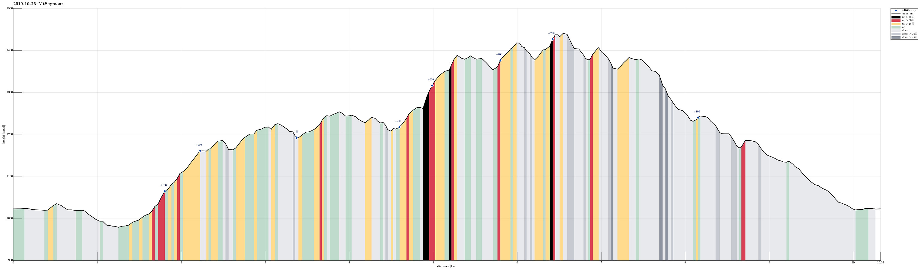
| Distance | 10.3km |
| Vertical meters | 831m |
| GPS |
|
| Ascents | Mystery Peak (1,230m) | 26.10.2019 |
|---|---|---|
| Pump Peak (1,395m) | 26.10.2019 | |
| Mount Seymour (1,449m) | 26.10.2019 | |
| Mount Seymour Second Peak (1,425m) | 26.10.2019 | |
| Visits of other PBEs | Mount Seymour Parking (1,020m) | 26.10.2019 |
Trip Summary
The weather seemed to promise a nice day and plans were already made in advance! :-) To get started, we had rented a car that would bring us all the way up a little over 1000mosl at the parking lot at the Mount Seymour ski resort, clearly limiting the overall height to climb on this hike!
Mystery Lake
Instead of following the main trail to Mount Seymour from the parking lot, we had planned to visit Mystery Lake, first. While heading for the trail head of the Mystery Lake Hike, rounding Loch Lomond right north of the parking lot, we suddenly became unsure and started to think that we had made our turn to early (while in fact we were 100% right!). Since we did not see any trail markers right where we were, we turned around and went back and then up the main gravel road west of the ski lift in order to find the trail head further up. Since this did not happen, we turned around once again and started following a well visible trail right north of the parking lot (but south of the actual Mystery Lake Hike) in eastern direction. Asking a person right there did not help, unfortunately, as he "confirmed" that we were now, after all, on the right track and that we simply had to continue on the trail that we had just started with (the Goldie Lake Trail). Walking down this trail for a bit (in the north of Flower Lake), we became unsure (again!); this time with good reason! Checking a mobile map, after all, we understood our situation and made a new plan for getting up to Mystery Lake (which started with going back up what we just had descended along Goldie Lake Trail!). Instead of going all the way up to the parking lot, however, we decided that we would try to short-cut over some downhill slopes that cut down the forest in north-south direction (roughly speaking on the axis between Flower Lake in the south and Mystery Lake in the north). Even though there was not really any reasonable trail along these slopes, stepping them upwards was still easy and straight-forward and at about 1100mosl, we connected, finally, to the Mystery Lake Trail. From there, it was then only about 60 more height meters up until we reached Mystery Lake. This picturesque little lake is kind of tucked away, even though it's quite close to the skiing resort, and as such very much worth a visit!
Mystery Peak and Brockton Peak
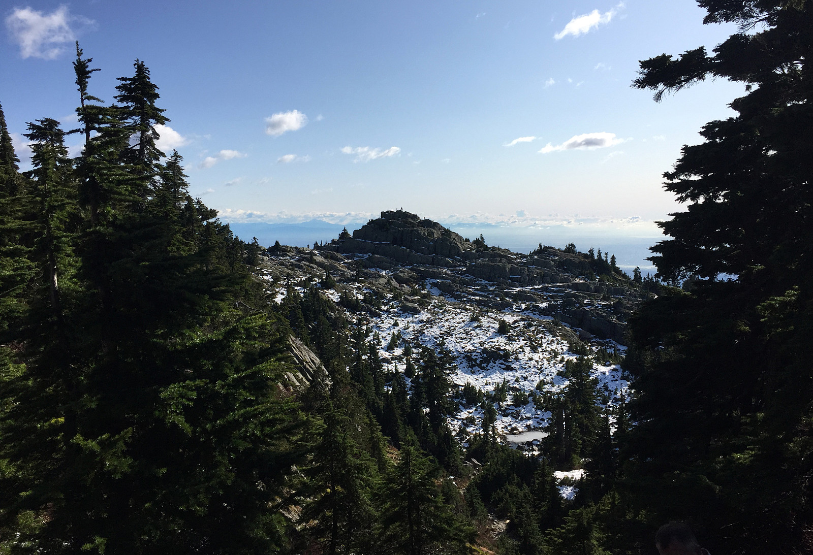
Our next overall goal, after having enjoyed Mystery Lake, was then Pump Peak (also called the First Peak). On the way there, two smaller tops were kind "in the way", Mystery Peak and Brockton Peak. Both of them were easily reached from the main trail(s), offering nice views, for example down to Vancouver. Once one gets past Brockton Point, a relatively big info plate explains that one changes from easy hiking to a bit more demanding backcountry hiking. Still, the main trail (Mount Seymour Trail) is very easy to find and straight-forward to hike.
Pump Peak, Tim Jones Peak, and Mount Seymour
From Brockton Point, following the main trail, one first walks down a little, before then starting the next major ascent along this hike, i.e., up to Pump Peak (the steepest part of this section begins after a trail fork in the east of Pump Peak and then heads up to Pump Peak in western direction). Only a little below 1400mosl, one then reaches a small saddle with Pump Peak on the left (in the south). If one wishes to enjoy the wonderful view from the top of Pump Peak, one definitely should include the short detour to the very top of this mountain (approaching it from the west!). Once done with Pump Peak, one can easily include also the Second Peak (Tim Jones Peak) and then also the Third Peak (Mount Seymour). Hiking over from First Peak to Second Peak is really straight-forward and one reaches another small saddle very close to the top of Tim Jones Peak. It's then easy and quick to include the very top of Tim Jones Peak, but honestly speaking, it's not really worth it. From the saddle, however, the trail connection to the Third Peak (Mount Seymour) proved to be challenging on this October day: a lot of ice, mixed with very hard snow, on partially very steep terrain made it necessary to be very careful! Eventually, we found it safer to step around some of the most exposed sections. Once on the saddle between Tim Jones Peak and Mount Seymour, we stepped out of the shadow, again, which made progress a lot easier (much less ice!). Soon after, we had arrived on the top of Mount Seymour, which really is worth the extension from Pump Peak (even greater views!).
Back along the Old Mount Seymour Trail
Since time had progressed and we really did not have any interest in ending up in the dark, we did not spend much time on Mount Seymour (we just ate a little and took some photos). Instead, we soon turned back and followed the trail that we had taken there, now in southern direction. Passing the slippery sections (up to Tim Jones Peak) was easier then stepping them downwards and soon we had passed this saddle, also. Getting over to Pump Peak was then also easy and straight-forward. At Pump Peak, we decided that we were up for trying a little variation on the way back, following the old Mount Seymour Trail. This trail is much harder to find (basically not marked at all!) and it appears that the local authorities do not want one to find it (it's non-trivial). After getting around the southwestern slope of Pump Peak, the trail starts to fall off very steeply into the direction of Brockton Point (you are required to go down onto all fours to safely step down there!). After the very steep descent, however, everything gets very easy, again, and reaching Brockton Point is then straight-forward. From there, we then followed the main trail into the direction of the parking lot. At the point, where this trail splits from a gravel road, which follows one of the skiing slopes there, we then decided that we would prefer the gravel road over the trail and followed it down to the parking lot swiftly.
Conclusion
All in all, the Mount Seymour Hike is really nice for several reasons. (1) Starting from about 1000mosl, already, makes it easy to focus on enjoying the higher regions of the mountainous north of Vancouver with lots of great views! (2) With less than 800m elevation gain (altogether on our hike), this hike is not too demanding, while still offering several peaks! (3) At least the main trail is really easy to find!
Photos
Selected photos are available as Google photo album.
Useful Resources
See also the related FB-page Hiking around Bergen, Norway and the web page of the Grouse Grind Trail.
Web page Vancouver Hiking Trail Guides offers rich information about hiking opportunities near Vancouver, including the Mount Seymour Hike and the Mysery Lake Hike.


User comments