
Veten i Åsane (22.09.2019)

Written by HHauser (Helwig Hauser)

| Start point | Hordvik (60m) |
|---|---|
| Endpoint | Hordvik (60m) |
| Characteristic | Hike |
| Duration | 3h 45min |
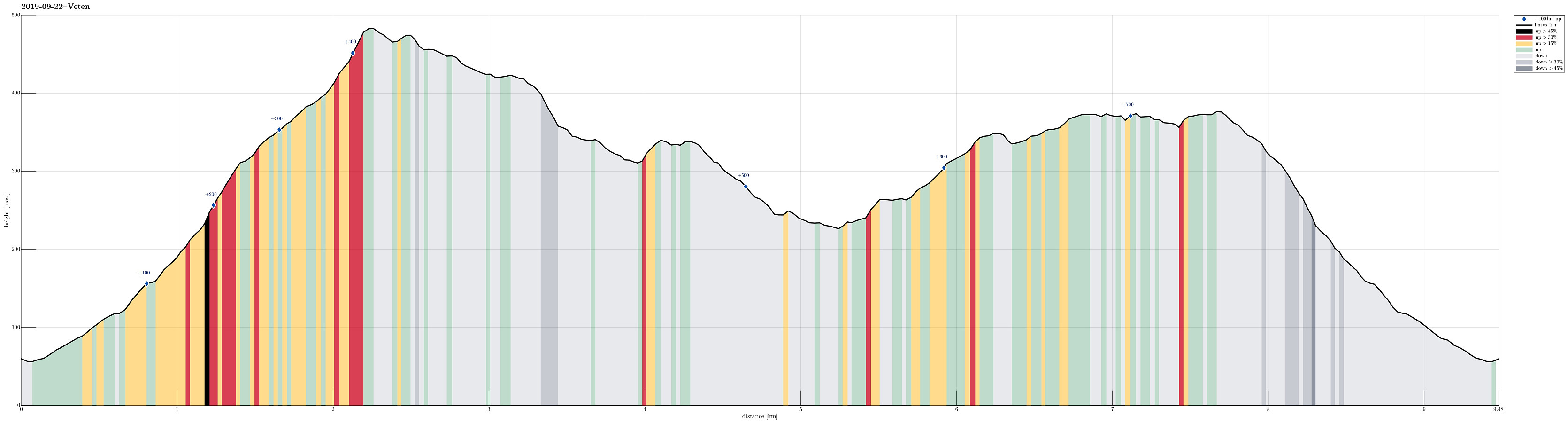
| Distance | 9.5km |
| Vertical meters | 740m |
| GPS |
|
| Ascents | Bjørndalsrindane (375m) | 22.09.2019 |
|---|---|---|
| Håkeberget (428m) | 22.09.2019 | |
| Skagen (342m) | 22.09.2019 | |
| Veten i Åsane (486m) | 22.09.2019 | |
| Visits of other PBEs | Skagen søyle (339m) | 22.09.2019 |
Trip Summary
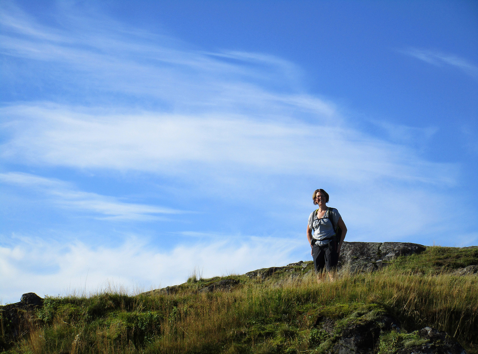
Since time was limited, we chose a hike not too far from Bergen and not long a hike, neither. Since we had talked about Veten (Veten i Åsane), we decided that we would hike it, once again. To add a bit of variation, however, we chose to approach it from the north, this time. We thus took the car from Bergen via Åsane along the E39 (into the direction of Knarvik). Before approaching the bridge, north of Åsane, however, we turned right onto road 5346 that leads to Steinstø. Shortly after, we turned left again and onto a narrow road that brings one to Hordvik. There, near Hordvik kindergarden, we parked and started our hike (in southern direction). We first followed a small road, right next to a little stream that comes down from Veten (on its eastern side), until we crossed E39 by walking through a little tunnel underneath it. From there on, the continuation was on a well-visible trail then. At about 115mosl, we used a convenient little bridge to cross over one of the streams, coming down from Veten. Right after the bridge, the real ascent to Veten starts (reasonably steep upwards, in southern direction, along the ridge). After first hiking through the forest, one soon passes the tree line. Then, one should not forget to turn around every now and then and enjoy the views towards the north. After a short but intense ascent, one then ends up directly at the top of Veten. From there, we continued in southern direction, hiking over the ridge of Veten (first over Folldalsnipa, then over Håkeberget, and then down over Raunleitet to Skagen). At Skagen, we then enjoyed a little break, before we turned back. Instead of walking back the same path that we had taken to Skagen, we descended further (towards Sæterstøl), before then finding a trail that leads into the direction of Storsåta. Once down in the valley (and over a small bridge), we through that it could be fun to also include Litlafjellet. First, we followed a nice little forest trail that leads one more around Litafjellet than up to it. We thus decided at one spot in the southeast of Litlafjellet that we would attempt it without a trail. After stepping up in steep terrain a few steps, we got the impression that Litlafjellet is quite densely covered with a forest. Instead of turning around, however, we fought ourselves throught the quite thick forest. Every hope that soon this would be over and we would reconnect to a path over Litlafjellet were without reason. It seems certain, based on our exploration, that there is nothing like a trail over this little hill! :-) Fortunately, Litlafjellet is small and thus we made it out of the thick forest after a short while on the other side. In fact, we stepped out of the forest more or less exactly where the trail up to Storsåta starts. After having picked off some needles etc., we then enjoyed the nice and easy-to-follow trail up to Storsåta. To be fair, one needs to mention that this path is not really leading all the way up to Storsåta, just almost. It spares the very top of this little hill and it seems that everyone, who is keen to indeed stand on the top of Storsåta must accept another (short) bush war. Since we had gone through something similar just moments ago, we decided to leave Storsåta alone and continue our hike into the direction of our car. According to the map, we expected a nice trail, starting near Storsåta and leading in parallel to Veten in northwestern direction. While we indeed found what seems to be this trail, one must understand that this is by no means an easy-to-find (or often used) trail. Instead, a good bit of luck is needed to not deviate from this trail. At about 375mosl, we first enjoyed the view (towards the east, first and foremost), before continuing. Our plan was to connect first to Stonghaugen and there find a better trail (down via Bjørnskarhaugen). First, we started into the right direction, but somehow we lost faith in our proceeding. Instead, we got the idea that we should cross over the little valley on our left (west). Since this proved non-trivial due to a rather steep terrain, we first went back (more or less to the point where we had stopped before). There, descending into the little valley was easy. Crossing some pretty wet terrain down in this small valley, we got over to the other (western) side and proceeded "diagonally upwards" from there. After a short while, we understood that we had come "too far" westwards, connecting back to the trail, which we had taken up in the beginning. At this moment, we were not motivated to once again go back. Thus, we just followed the same trail down (which we had stepped up in the beginning). Soon afterwards, we were back to our car. While we were not fully satisfied with having missed the alternative route down, we still were happy with another good hike in excellent autumn weather.
Photos
Selected photos are available as Google photo album.
Useful Resources
See also the related FB-page Hiking around Bergen, Norway.
Petter Bjørstad has a useful page about Veten and also web page WestCoastPeaks.com provides useful information about Veten.
On Bergentopp 200 there is a page (in Norwegian) about Veten.


User comments