
Gulltjørna via Trengereidhotten from Risnes (29.06.2019)

Written by HHauser (Helwig Hauser)

| Start point | Risnes (65m) |
|---|---|
| Endpoint | Risnes (65m) |
| Characteristic | Hillwalk |
| Duration | 5h 45min |
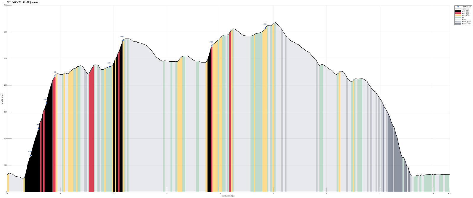
| Distance | 8.3km |
| Vertical meters | 877m |
| GPS |
|
| Ascents | Ramfjellet (428m) | 29.06.2019 |
|---|---|---|
| Trengereidhotten (577m) | 29.06.2019 | |
| Visits of other PBEs | Risnes Kalkstensbrudd (440m) | 29.06.2019 |
The ascent from Risnes is very steep, there is no trail, you have to step around cliffs, at times you use four points to make it -- don't try this one as your first off-trail hike! The descent from Ramfjellet was also steep and without a trail -- consider your choice!
Trip Summary
We left Bergen in eastern direction on E16 (into the direction of Voss), leaving the main road just before Romslo, changing to the old road that brings one through Romslo to Risnes. We found a suitable place to park in Risnes and started our hike from there.
Krånuken
Our first goal was Krånuken, to get up onto the heights north of Gullfjellet. For years, already, I had looked at this idea of ascending Trengereidhotten from the north, but hesitated (now I know that this was for good reasons!). This time, we finally decided to give it an attempt. We chose Sverinden, leading up to Krånuken, as the line and started from the street, where it passes under a short tunnel at the northern end of Sverinden. Immediately, our expectations were confirmed: the ascent over the ridge of Sverinden is very steep, there is no trail, and a number of cliffs require that one chooses the detailed direction of ascending carefully. While it was necessary to occasionally use our hands in addition to our feet, we still made the ascent without any major difficulties. Once one then stands on Krånuken, proceeding further gets much easier. Also, one can enjoy some very nice views over Sørfjorden and over to Osterøy from Krånuken.
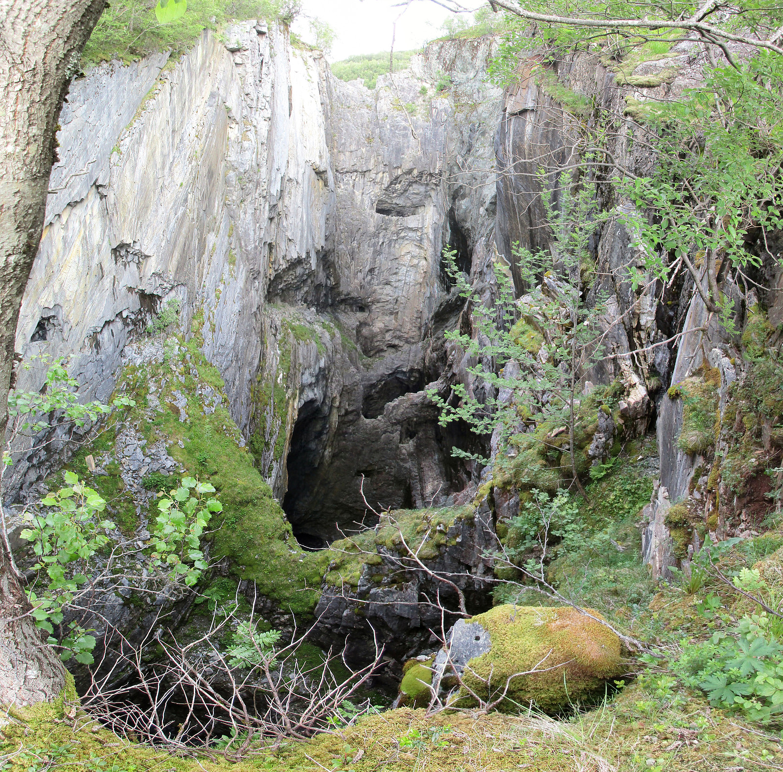
The quarry and Trengereidhotten
Continuing southwards across the heights south of Krånuken, we got close to the former limestone quarry of Risnes. And what a view this is?!! High up in the mountains, basically inacessible from Risnes, they started a limestone quarry about 100 years ago, operating it until the mid-1980s, or so. What remains until today, are immense vertical holes in the mountain. They are dozens of meters across and many, many stories deep! One really wonders, who this quarry was operated and what the working conditions must have been. Very impressive indeed! We rounded the quarry in its west, turning into southeastern direction (up a small valley) as soon as we had come around the quarry. On the other side of the saddle, we descended the few meters to Risnestjørnane. Crossing over between them, we got closer to Trengereidhotten. After having rounded another, smaller hill, we eventually started our ascent to Trengereidhotten from its west. Without any trail (still), this ascent is possible without any problems (but it's quite a bit steep, also). On Trengereidhotten, having found a convenient wooden platform near the widely visible tower, we enjoyed a short break with a bit to eat and drink.
Gulltjørna
After all, we found ourselves hiking along a trail, at least for a short stretch! :-) From Trengereidhotten, we walked over the heights in southern direction, descending to Rundtjørna. Instead of continuing into the direction of Gullbotn (main trail there), we rounded Rundtjørna on its north, connecting to Langatjørna, which we also rounded in its north then. From there, we crossed (now in western direction) over some minor heights until we looked down to Timbertjørna. From the east of Timbertjørna, we could nicely see over the lake to the other side, identifying a stretch of grass as a likely opportunity to connect further to Gulltjørna. And indeed, after we had crossed over in the south of Timbertjørna, we found this stretch of grass straight-forward to traverse (steep, yes, but no problem). Staying near the high cliff-wall (in the south) as close as possible, we easily got over into a small valley that would lead us, in southwestern direction, more or less directly to Gulltjørna. After having crossed over a small saddle, we finally saw Gulltjørna in front of us. And what a nice view this is?!! Gulltjørna is impressingly surrounded by some major mountain sides. It empties into the north and into Risnesdalen, providing a lovely view and spot to be! And clearly, yes, Gulltjørna's waters are refreshing, also in June! :-)
Back down to Risnes
From Gulltjørna, we then started our descent back to Risnes. Even though we still had very clear memories of the very steep ascent, we decided to follow our original plan, i.e., to attempt a descent between Risnesdalen and Romslodalen. We started with a diagonal ascent to the northeastern ridge of Gråfjellet, from which we had a great view down to Romslabotn. We then followed this ridge further down (in northeastern direction). In order to avoid getting too deep into Tverrdalen, we crossed over (in northwestern direction) to Ramfjellet. Passing by a small cabin, northeast of Ramfjellet, we finally ended up in steep and non-trivial terrain. We first managed to keep ourselves to the ridge as much as possible (continuing in northeastern direction, towards Risnes). At about 300mosl, however, we did not manage to connect over to Risnesrinden (as originally planned). Instead, we ended up in the west of Stollane. Descending carefully (and slowly) the very steep mountainside, we eventually had made it to one of the posts of the powerline that run (more or less) parallel to Risnesvegen. Almost down to the road, we once more were challenged by particularly steep terrain. With a bit of searching and using all fours, we nonetheless made it safely down to the road. From there, then, it was only a short walk back to the car.
Conclusion
All in all, this hike was (a) an adventure (steep ascent first, steep descent last), (b) very interesting (the former limestone quarry), and (c) just lovely (all the hike across the heights north of Gullfjellet, including Gulltjørna as particularly nice place)! Quite a bit for one hike! :-)
Photos
Selected photos are available as Google photo album.
Useful Resources
See also the related FB-page Hiking around Bergen, Norway.
The web site of Bergen Byarkiv (the City Archive of Bergen) provides an interesting page about Risneskalk (in Norwegian).
Web page WestCoastPeaks.com provides useful information about Trengereidhotten and Mannaleitnipa.
Web page Bergen Byguide describes the much more usual hike to Trengereidhotten (from Gullbotn).


User comments