
Vedafjellet and Brøknipa from Skaftå (12.05.2019)

Geschrieben von HHauser (Helwig Hauser)

| Startpunkt | Skaftå (50m) |
|---|---|
| Endpunkt | Skaftå (50m) |
| Tourcharakter | Bergtour |
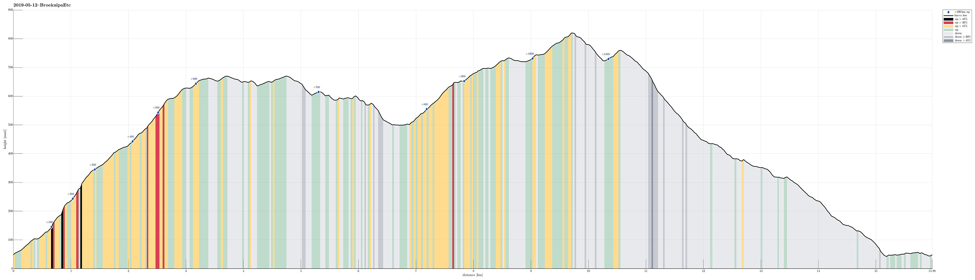
| Tourlänge | 5h 15min |
| Entfernung | 16,0km |
| Höhenmeter | 1.185m |
| GPS |
|
| Besteigungen | Bruviknipa (822m) | 12.05.2019 |
|---|---|---|
| Utegardsnipa (762m) | 12.05.2019 | |
| Vedafjellet (673m) | 12.05.2019 |
Trip Summary
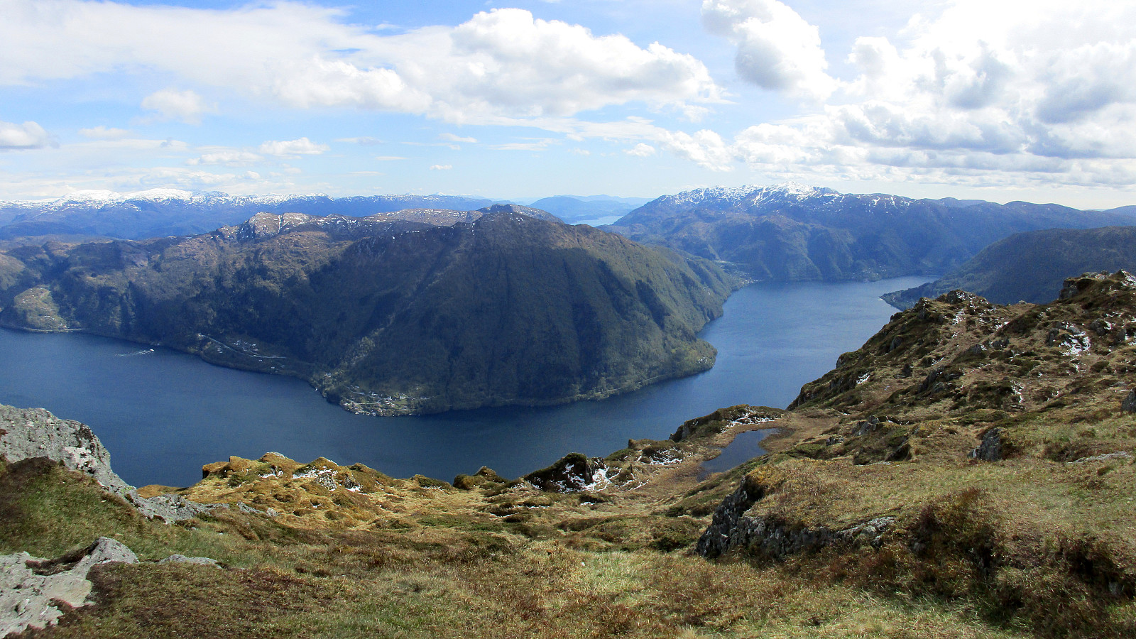
We left Bergen via Arna, continuing along road E16 in the direction of Voss, before then taking the bridge to Osterøy. On the other side, we turned right onto the narrow road towards Bruvik and followed it (on the northern side of Sørfjorden) for quite a bit. After getting around Stokkaneset and before driving into Skaftå, we parked near the sharp right-turn, which is built over the stream that comes down from Djupedalen. Right there, we forest road leaves to the north (and upwards), following Djupedalen for a short stretch (before turning left and upwards). We continued to walk up this forest road until it eventually swings to the left for good (at about 135mosl). There, we found the trail head, as planned. After a few meters of leading further northwards, the trail crosses a little stream to the eastern side of it. There, one can easily find a nice path that leads upwards through the forest, following a narrow ridge that is coming down there. Hiking more or less exactly on top of this ridge (north- and upwards), we ascended swiftly to some intermediate heights (at about 475mosl), where a small number of simple houses are found. From there, instead of staying "down in the valley", we ascended a bit steeply in northwestern direction to Grønfjellet. Once up there, we enjoyed a nice hike over the heights towards Vedafjellet. There, we wished to get a view down to Storavatnet and so we walked to the northern "edge" of Vedafjellet (Skoddberget), enjoying the view from there. After a short discussion about the continuation (down over Vedaflærne and back via Stangfjellet, or back over Vedafjellet and down to Gallnanipa), we decided to do the latter. Quickly, we returned to the point, were the well-marked path leads down from Vedafjellet (in western direction). Shortly after, we had started our "traverse" towards Flatafjellet (via Gallnanipa, Varden, and Vindegga). Even though these small tops are clearly lower than Vedafjellet and Flatafjellet, one still has some very nice views from them! :-) At Vindegga, we crossed another trail that connects Storavatnet and Skaftådalen, following our plan to first ascend to Flatafjellet (and then from there continue to Brøknipa). The ascent to Flatafjellet (in the north of Skaftådalen) was then nice and quick. Once up there, we then changed direction (towards the southeast, i.e., towards Brøknipa). Hiking along the steep western side of Flatafjellet is really nice with lots of great views. This way, we quickly ascended to Ørnatuva, where one could continue to Utegardsnipa directly. Instead, and as planned, we walked over to Brøknipa and enjoyed some excellent views from up there (Brøknipa is one of the nicest mountains on Osterøy!). From there, we then headed westwards (towards Utegardsnipa). To get there, we used a rather straight connection, which dips a little between the two tops, but is nice and straight-forward to find. At Utegardsnipa we again enjoyed fantastic views over Sørfjorden; definitely worth a visit! From there, we then descended along its southwestern ridge ("pointing" towards Skaftå). Also this descent is really nice as one hikes towards Sørfjorden "all the time". At about 400mosl, the path swings to the right (north) and into Skaftådalen. One passes a few "houses" there, before the trail turns left (and down), again. Following the trail, we found a bridge to cross Buldrå (the stream that runs down Skaftådalen). On the other (western) side of the valley, we then connected to a forest road, which leads all the way down to Skaftå. Before actually getting all the way down, one passes by the remains of an impressive quarry that was cut deep into the valley, parallel to the stream and the forest road. Eventually, after having reached the road (Bruvikvegen), we walked back to the car (not long). The last few minutes it had started to rain and we were highly satisfied with this nice hike in good weather. Clearly, this alternative option to reach Brøknipa is highly interesting and can be recommended to all those, who like the idea to approach this nice mountain "from sea level".
Photos
Selected photos are available as Google photo album.
Useful Resources
See also the related FB-page Hiking around Bergen, Norway.
Petter Bjørstad has a useful page about Vedafjellet and another one about Brøknipa; and also web page WestCoastPeaks.com provides useful information about Vedafjellet as well as about Brøknipa (he writes "In my personal opinion, Brøknipa is one of Hordaland's finest mountains").


Benutzerkommentare