
Bogafjellet from Reinsvegen (18.11.2018)

Written by HHauser (Helwig Hauser)

| Start point | Reinsvegen (50m) |
|---|---|
| Endpoint | Reinsvegen (50m) |
| Characteristic | Hillwalk |
| Duration | 3h 45min |
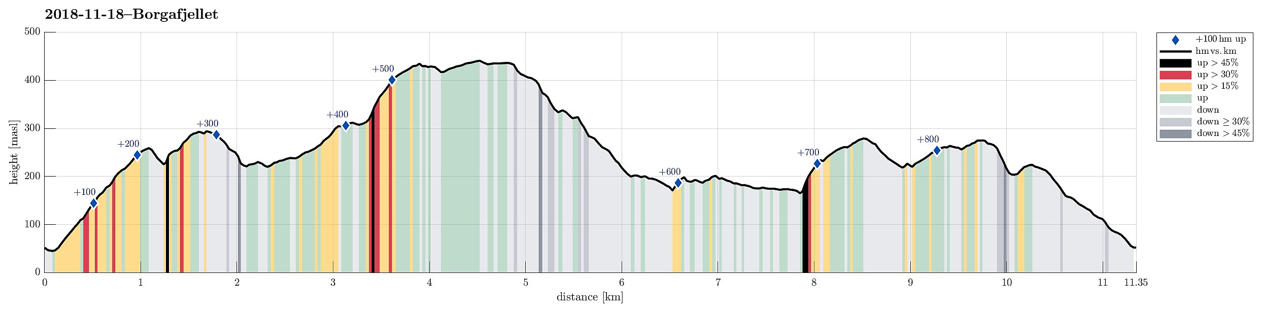
| Distance | 11.3km |
| Vertical meters | 856m |
| GPS |
|
| Ascents | Bogafjellet (442m) | 18.11.2018 |
|---|---|---|
| Høgåsen (300m) | 18.11.2018 | |
| Snøkkja (282m) | 18.11.2018 | |
| Veten i Fusa (281m) | 18.11.2018 |
It happened that I climbed up the steep southern flank of Bogafjellet; check carefully before following this track (and possibly aim for an ascent to Bogafjellet that is less steep, for ex., further in the East)!
Trip Summary
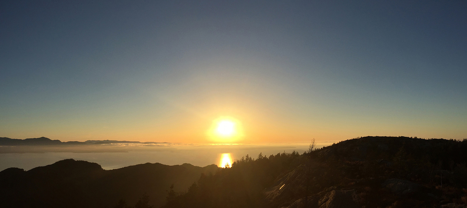
Even though the weather, with very low hanging clouds, did not look all to promising for a hike somewhere higher up, I still decided to give it a try and headed south and towards Fusa (via Osøyro, then taking the ferry from Hatvik to Senjaneset). Even on the ferry across Fusafjorden I wondered, whether it was that good an idea at all (the impression which the sun made, breaking through the low-hanging clouds, however, was definitely worth the view!). After arriving in Fusa, I quickly turned right from the main road and followed road 122 towards Strandvik (via Vinnes). Before actually getting to the "center" of Strandvik, I turned left and headed towards Reinsvegen. Passing by Kvåle, I drove up the valley until a spot near Snøhaugen. From there, I had planned to hike a round across Bogafjellet.
Spondalshovda
After leaving my car, I first headed towards Spondalshovda, directly in the north of where I had parked. A nice path lead steeply up the hill and by that time, I found myself bathed in the most beautiful November sun you can wish for! Ascending quickly, I decided to leave the main trail (shortly before it reaches the saddle and just a few steps after a major hairpin turn. Following some white plastic markers, I got to the top of Vikåsen. I then continued (into eastern direction) down the ridge of Vikåsen until I got a saddle, which leads over to Høgåsen in the north of Vikåsen. I followed a just noticeable trail first up in northern direction and then turning left (and in western direction), leading up to the top of Høgåsen along its eastern ridge. Even though also the top of Høgåsen is full of trees, one still can enjoy some nice views to Boga and Bogafjellet from there. Since it was pretty clear at Høgåsen that proceeding into western direction could easily lead in all-too-steep terrain, I decided to walk back the route which I had taken up (at least to the spot, where I had first turned left). After descending a bit from Høgåsen (in eastern direction), I turned left (and in northern direction) in order to find a connection to Bogafjellet (I thought that I could try it this way, instead of descending all the way down to the Vik-valley in the East, but must note that it's not really a standard way of connecting to Bogafjellet).
Bogafjellet
After turning left in the east of Høgåsen, I followed some minimal track further north, connecting to the trail which comes up from the Vik-valley in the East, crossing over to Boga in the West. I followed this trail up and over the saddle for a bit, thinking that I may find a path that connects to Bogafjellet from up there. Right over the saddle, I enjoyed the view down to Boga in lovely November sun. I also found a tractor road that lead up the ridge (in Eastern direction) very close to the saddle (and north of it). Hoping that this trail may lead further up to Bogafjellet, I followed it first. Soon, however, the tractor road ended and I was on my own heading north and towards Bogafjellet. First, all that was easy and I proceeded quickly upwards and across some wet, swampy area. I knew that the southern flank of Bogafjellet was steep and I tried to surround it in its east. While heading northeast, I got closer to the steep mountain side and wondered what to do. At one point, looking carefully, I got the impression that I spotted a possibility to climb up through the steep side nonetheless (instead of heading further northeast and searching the path on the ridge there). After all, it was no big problem to do the climb, but I needed my hands and it was indeed very steep in selected places. This ascent is clearly not recommended unless you enjoy some climbing in unclear steep terrain. After this somewhat more exciting part of the hike, I found myself on the eastern ridge of Bogafjellet and headed up to the top in the west swiftly. Crossing over Bogafjellet in the early evening was definitely a treat with the low-standing sun coloring the surrounding mountain landscape in orange and red!
Snøkkja and Veten
After crossing Bogafjellet, I found the major trail, which leads up and down Bogafjellet in its west and it was easy and quick to descend from Bogafjellet along this path. Near Hovda, I found a gravel road, which connects with Rein and Reinsvegen further down (in the southeast). I followed this road until I got to the upper-most house (Reinsvegen 299). Just meters further down, where the road makes a major turn to the left, an almost invisible sign recommends to go up (in Western direction), if one wishes to connect to Skåtavatnet, for example. Since I was heading for Snøkkja in the south of this place, I considered to crossing the valley right there (but found it too steep and also difficult to traverse with a lot of trees being cut down there). After following the recommended direction for only a short stretch, I found a nice opportunity to cross over the valley and to connect to a gravel road (Dallandsvegen), which I followed (first westwards, then turning left into southern direction). Before this gravel road really goes down towards the south, I found a path leading up to Snøkkja in the east. At this time, the sun had already set and I needed to consider the situation with respect to the remaining light. Since I had packed my headlight, I continued with my plan to traversing Snøkkja on my way back to the car. The path lead steeply up to Snøkkja, which offers some nice views over Bjørnafjorden and also towards Folgefonna from up there. At the top of Snøkkja, I then found a new path, with yellow marks, that promised to bring me further into eastern direction. It was getting quite dark already, but finding the yellow marks turned out to be nicely possible (still without headlight). At a point near Skaret, however, I thought that the path would lead me all the way down towards the south and not up to Veten and thus I decided to search for a connection to the ridge that would bring me up to Veten. Doing this in the dark was a bit of a challenge, but I managed without any too big detours. Once on the ridge up to Veten, however, I found that the night had fallen for real and that it had become impossible to see anything between the trees. Mounting my headlight, however, I found my situation much improved and proceeding further was straight-forward again! :-) At Veten, I met another person, who enjoyed the evening there, and we discussed for a moment, how I should proceed. After all, I decided to go back a bit of what I had come up, before then turning right and searching for a tractor road that I had seen on the map. First following some red marks down the ridge, then turning right (and eastwards) and from there following some white marks, I quickly found myself on the relatively steep descent through some dark forest. Quite interesting, actually, to do this in total darkness, lit up "only" by a headlight! Near Skorafjellet, I knew that I had to cross over in order to find the tractor road (in the north of Skorafjellet). Stepping over the remains of cut down trees there, I was positively surprised that I could find the tractor road relatively easily (the road itself is not so much a road, really, but was used for forest works there before).
Conclusion
Once on the tractor road, descending further towards Reinsvegen turned out to be no problem at all and shortly after, I found myself finding the car at exactly the place, where I was coming down from the mountain; I had managed to complete my round as originally thought (even though it got a bit more challenging than necessary due to the darkness at the end of this hike). All in all, I really enjoyed this hike and the beautiful November sun a lot! :-)
Photos
Selected photos are available as Google photo album.
Useful Resources
See also the related FB-page Hiking around Bergen, Norway.
Petter Bjørstad has a useful page about Bogafjellet and also web page WestCoastPeaks.com provides useful information about Bogafjellet.
Web page UT.no from the Norwegian Trekking Association recommends a different hike (from the north) and another one (from the west).


User comments