
Vemånen, Hovden, etc. (30.09.2018)

Geschrieben von HHauser (Helwig Hauser)

| Startpunkt | Unneland Kultur og Aktivitetshus (100m) |
|---|---|
| Endpunkt | Unneland Kultur og Aktivitetshus (100m) |
| Tourcharakter | Bergtour |
| Tourlänge | 2h 30min |
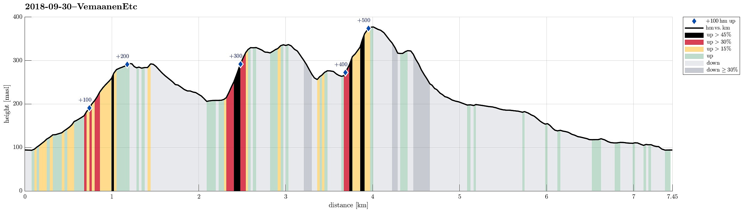
| Entfernung | 7,4km |
| Höhenmeter | 539m |
| GPS |
|
| Besteigungen | Bjørndalshovden (380m) | 30.09.2018 |
|---|---|---|
| Hovden i Bergen (339m) | 30.09.2018 | |
| Vemånen (297m) | 30.09.2018 |
Trip Summary
On this day with a "mixed" weather prediction, we decided to do a smaller hike, still trying something new. We parked near the Unneland Kultur og Aktivitetshus at Unnelandsvegen 253, 5268 Haukeland, and walked from there.
Vemånen
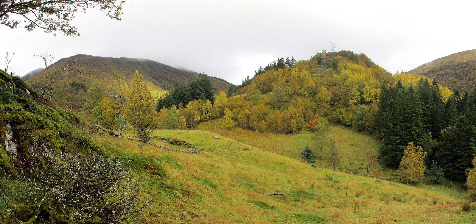
Immediately after crossing the bridge over the stream that comes down from Seterdalen (as well as from Rambjørgsgjelet), heading towards Haukelandsvatnet (at Nesvika), we found the path to Vemånen (first passing by Rodalshaugen). This is a very easy to find and nice to walk path, following the ridge (mostly in northern direction) up to Vemånen. Near the top of Vemånen, one gets out of the forest and can enjoy some nice views, in particular over Haukeland and Haukelandsvatnet. The best viewpoint, however, is not at the "top" of Vemånen, but a few meters in the southwest of the "top" (and it's worth going there). We then left Vemånen along its northeastern ridge, into the direction of Skåldalselva.
Hovden and Hardbalhovden
At about the saddle between Vemånen and Hovden, we connected to the street (Gullfjellsvegen), which crosses over here, too. In order to ascend to Hovden, we had decided to try this from the northwest. Accordingly, we first followed the road (for a few meters only) and then, right after the turn (into eastern direction) and just before coming close to a few houses, we left the road and ascended (more or less along a straight line) up to Hovden. Given several other trip reports that described the ascent to Hovden as not exactly enjoyable, we were prepared for some bush war at this section. But fortunately, ascending to Hovden was straight forward and not difficult (the ascent is relatively steep though). Once on Hovden, it was also easy to connect further to Hardbalhovden, crossing over a small saddle (and along a curved trajectory). After exploring the top of Hardbalhovden a bit, we then descended towards the east over another ridge of Hovden.
Bjørndalshovden
Our next goal was Bjørndalshovden and we decided to approach it directly, i.e., without descending to the road (Gullfjellsvegen). At the saddle, we came close to some houses, but managed to pass them over a nice little hill in the middle of the valley, gently descending towards another saddle, right in the southwest of Bjørndalshovden. From there, the ascent was steep but very well possible and straight forward, more or less following the power line, which goes overhead there, also. Once on Bjørndalshovden, we continued towards Osavatnet along the eastern ridge of Bjørndalshovden.
Back via Skaret and Seterdalen
After getting down to the southwestern end of Osavatnet from Bjørndalshovden, we turned around and towards Seterdalen. We first crossed Skaret, which is the saddle to the higher mountains on the southern side of this valley (including Slettegga). We descended through some relatively dramatic nature at Skaret and came down to Skarabrekka, where we crossed the water, which comes down from Katladalen above, including two nice waterfalls, also. In the valley, we then followed a gravel road, passing by Hardbalhovden (now in our north). Before the road turns right (northwest) and to some houses there, we followed a simple path that continues parallel to the stream into Seterdalen. Further down, this path connects to another gravel road, which we followed then for a bit. Before this road then connects back with the main road, we crossed the stream over a nice bridge in order to get to the other, southern side of the valley. There we then found a path, which brought us all the way back to the end of the valley and very near to the place, where our car was parked.
Conclusion
While our expectations were limited (also influenced by some other trip reports that described Hovden as "unfriendly" hill), we really were very positively surprised, after all: in conclusion, the entire hike was nice and walking it did not include any difficulties. In that sense, this nice autumn hike was a positive surprise! :-)
Photos
Selected photos are available as Google photo album.
Useful Resources
See also the related FB-page Hiking around Bergen, Norway.


Benutzerkommentare