
Via Purkedalsgjelet to Kofta etc. (02.09.2018)

Geschrieben von HHauser (Helwig Hauser)

| Startpunkt | Storebrekken parking (35m) |
|---|---|
| Endpunkt | Storebrekken parking (35m) |
| Tourcharakter | Bergtour |
| Tourlänge | 7h 45min |
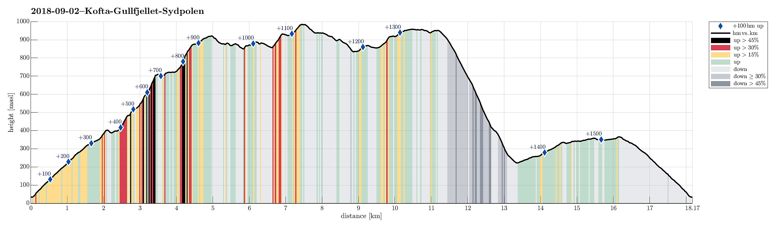
| Entfernung | 18,2km |
| Höhenmeter | 1.519m |
| GPS |
|
| Besteigungen | Gullfjelltoppen (987m) | 02.09.2018 |
|---|---|---|
| Søre Gullfjelltoppen (962m) | 02.09.2018 | |
| Kofta (921m) | 02.09.2018 | |
| Sydpolen (952m) | 02.09.2018 | |
| Besuche anderer PBE | Brekkekleiva P-lomme (35m) | 02.09.2018 |
| Høyde ved Brekkesetret (405m) | 02.09.2018 |
Note that this hike is maybe better suited for experienced hikers. It's comparably long and partly through challenging sections (no trail).
Trip Summary
This hike, and in particular the part through Purkedalsgjelet up to Kofta, was one that asked for a careful preparation. It's recommended that you study the circumstances carefully and choose also the weather conditions appropriately. In order to enjoy this hike, you should (a) be at least somewhat experienced with hiking in the mountains around Bergen, in particular also without a path (finding your way, etc.) and (b) choose a dry day on which you can expect that there would not be too much water coming down Purkedalsgjelet (I'd rather not go this hike when snow is melting on Gullfjellet, or after some heavy rain). Take care (and enjoy)! :-)
Storebrekken
We parked along the road from Os to Samnanger (#137), which passes Gullfjellet on its eastern (generally very steep) side. Actually, we first missed the right spot and passed by it, only to return shortly after---it's not that clearly visible, when driving along the road. Once parked, however, the beginning of this hike is straight-forward: After reading a bit about the history of Storebrekken (an old military path, etc.) at the trail head, we followed the path up the steep mountain side towards Brekkesetret. This path, Storebrekken, comes with many serpentines, has quite some loose rocks along the path, but is otherwise easy to follow and hike.
Brekkesetret
Near the saddle to Brekkedalen, we left the path and stepped up to a little hill between the larger mountains (Søre Gullfjelltoppen, Kofta) in the north and Sauafjellet in the south. From there, we could do a first real-world visual inspection of Purkedalesgjelet (looking north). We confirmed that we would find it best to approach it from its left (western) side, first, before then (maybe about one fifth into the valley) crossing over to its other (eastern) side.
Purkedalsgjelet (hike up with care!)
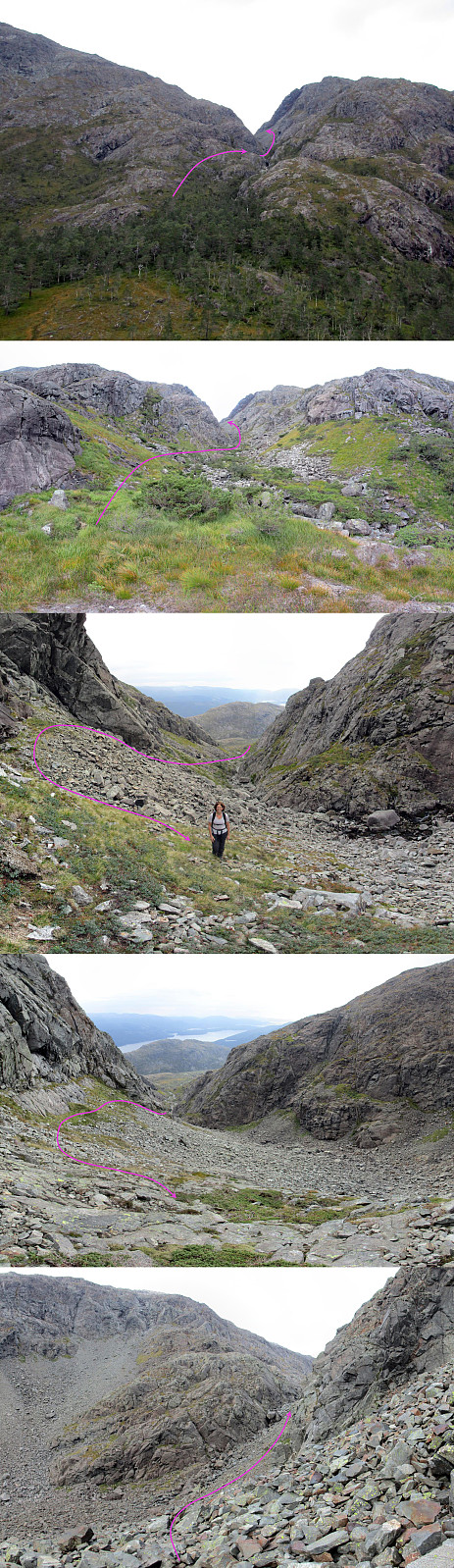
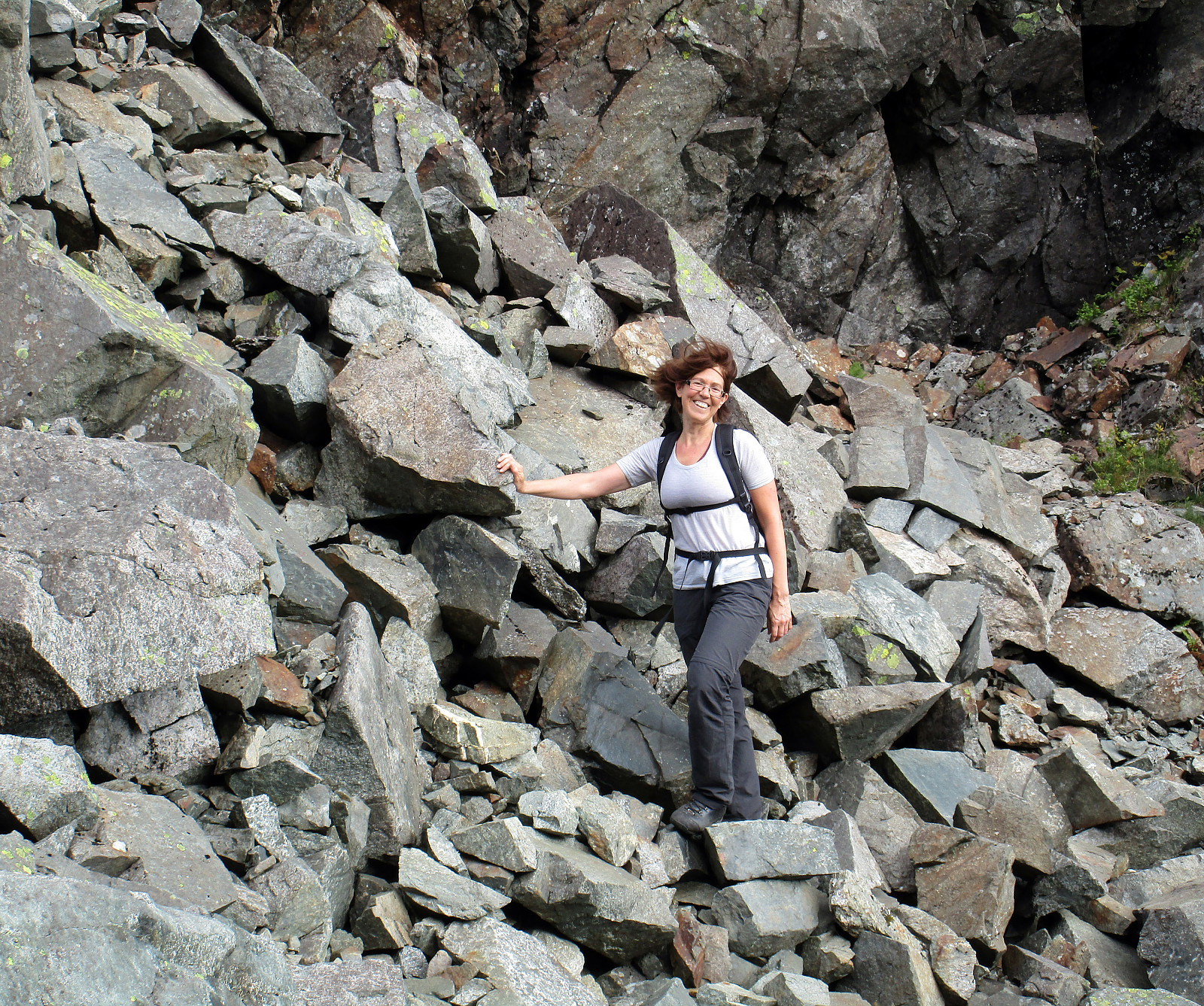
Once starting to approach Purkedalsjelet, we came across several river beds with large rocks and found it convenient that we had indeed chosen a dry day for our adventure (crossing and even following these river beds for a bit was easy and straight-forward). As planned, we crossed over to the western side of the water and started our ascent next to the valley (the valley itself seems to be too wild in its lower part). At about 500mosl, we started to enter the valley and crossed the water in it at about 520mosl (once you have found the ascent outside the valley on its western side, it's pretty obvious anyway, where you would enter the valley and cross the stream). From there on, we continued on the eastern side of Purkedalsgjelet, following it (steeply) upwards. One thing to take care of is that this part of Purkedalsgjelet is characterized by major screes of fallen rocks that are substantially steep. We found it best to hold ourselves to the upper parts of these screes (as much as possible). One may wish to use a helmet in this part, also. Once getting to about 700mosl, we needed to traverse a bigger scree in order to approach a rather narrow opening of Purkedalsgjelet (at about the same height, but a bit further north). This was maybe the most "hairy" part of the hike, altogether (stepping carefully over all the loose rocks on this scree, traversing it from one side to the other, required good concentration). Once in the narrow opening, we found an easy way to step up to the next section of Purkedalsgjelet. Here, again, it was good that we had chosen a dry day. We imagined that it may be hard or even impossible to do this crossing on a wet day, when more water comes down there. Once up there, however, the valley flattens out and one comes to a really nice little lake, right between Søre Gullfjelltoppen (on the left, west) and Kofta (on the right, east).
Kofta
After enjoying the scenery near the lake for a few minutes, we continued our hike, leaving Purkedalsgjelet towards Kofta in the east. Even though also there we could not identify anything that would resemble a path and even though also Kofta's side into Purkedalsgjelet is generally quite steep, we followed a route, which we had looked at already at home, heading first (more or less) directly up into a side-valley and then turning half-right (into southeastern direction). This way, we managed to reach the southern ridge of Kofta without great difficulties and then followed this ridge (in northern direction) up to the top of Kofta. From there, we then followed the somewhat longer northern ridge of Kofta, which connects to Gullfjelltoppen, after all. Following this ridge, we also enjoyed new views (in northern direction), for example down to Fagerbotnen as well as over to Gullbotnen.
Gullfjelltoppen
Once we came close to Gullfjelltoppen, we crossed over the very upper-most part of Purkedalsgjelet, forming a nice (and kind of sharp) saddle there. Following a small circle, which brought us up to the path to Gullfjelltoppen (the one that starts from Gullbotnen), we reached Gullfjelltoppen shortly after, enjoying a nice break near the top with an amazing view towards the north (seeing Osterøy, Sørfjorden, Ytre Arna, etc.).
Søre Gullfjelltoppen (Sydpolen)
From Gullfjelltoppen, we first followed the path towards Redningshytten for a short stretch (basically until it turns right towards Midtrinden). Instead of continuing on the path, we followed the southern ridge down from Blåmanen (into the direction of Søre Gullfjelltoppen). It also would have been possible to further continue along the path, since it gets close to the ridge towards Sydpolen once again a bit further down. Instead of continuing towards Gullfjellet (as the path does), we continued further southwards and towards Søre Gullfjelltoppen along the ridge, which passes by Gullfjelltjørnane on their eastern side. Hiking up this ridge, we crossed over Søre Gullfjelltoppen and arrived at the main cairn (a bit to the southwest of the highest point there), which also is a nice goal when hiking up here from Brekkedalen.
Back via Brekkedalen
From Sydpolen (Søre Gullfjelltoppen), we descended along its southern ridge into Brekkedalen (this really is a nice path for hiking up, usually!). We followed the path all the way down into the valley, not trying to do any shortcuts, or so. Once in Brekkedalen, we followed the gravel road back up to Brekkesetret, right next to lake Store Brekkevatnet. From there, we basically took the same path down (Storebrekken), which we had taken up in the beginning.
Conclusion
All in all, this definitely was (a) a major hike and (b) a very nice one, too! It was rewarding that our preparations to step through Purkedalsgjelet were refunded by a nice adventure (without any bad, unexpected surprises---we had been fully prepared to turn around, if necessary, and go back, should the passage through Purkedalsgjelet have proven to be too difficult for us!). With that, we can recommend this hike to those, who are experienced with such adventures and who prepare well, also choosing an appropriate (dry) day. Enjoy! :-)
Photos
Selected photos are available as Google photo album.
Useful Resources
See also the related FB-page Hiking around Bergen, Norway.
Petter Bjørstad has a useful page about Gulfjellet (and another one about Sydpolen) and also web page WestCoastPeaks.com provides a trip report through Purkedalsgjelet, as well as useful pages about Kuftofjellet, about Gullfjellstoppen, Litlagullfjellet, and Gullfjellet, and about S. Gullfjellstoppen.
Web page Fanaposten described this ascent, as well, using the notion "the most demanding hike to Gullfjelltoppen".


Benutzerkommentare