
Tverråsen, etc., and Furehaugen, etc. (19.08.2018)

Skrevet av HHauser (Helwig Hauser)

| Startsted | Berge parking (60moh) |
|---|---|
| Sluttsted | Berge parking (60moh) |
| Turtype | Fjelltur |
| Turlengde | 4t 00min |
| Distanse | 11,0km |
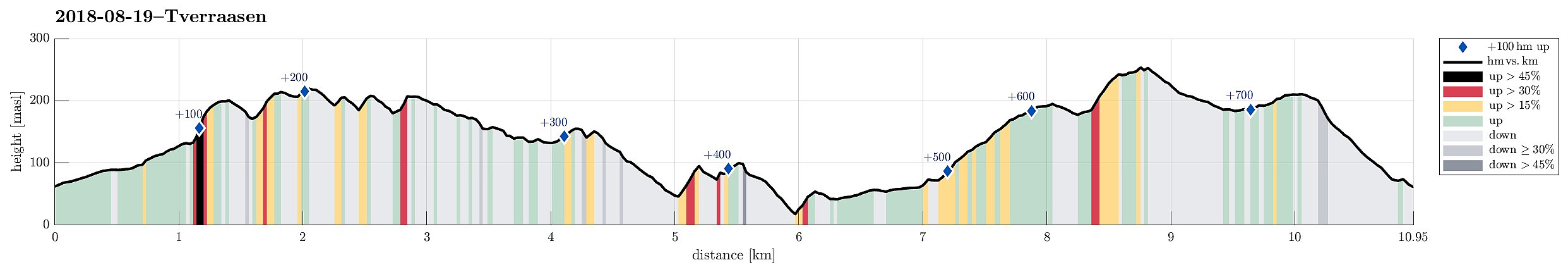
| Høydemeter | 735m |
| GPS |
|
| Bestigninger | Furehaugen (255moh) | 19.08.2018 |
|---|---|---|
| Tverråsen (222moh) | 19.08.2018 |
Note that most parts of this hike are without any trail.
Trip Summary
I drove from Bergen to Os in the south and then further into the direction of Hattvika, where a ferry can take you over to Venjaneset (Fusa). Only a few hundred meter before reaching the ferry stop, I turned left and drove up a little road towards Berge. More or less at the first possibility, I parked and started walking (first following the road further up, in northeastern direction). After passing by the houses at Tussaskarva, I found the spot, where the road crosses a little stream, coming down from the right (east). There, it was possible to leave the road and continue on a simple tractor road in northeastern direction (basically following the stream). At about 120mosl, the valley forks into two and I took the left one, continuing in norther direction. This lead me, as expected, to the road (through Lauvåsdalen), which I crossed there, taking a little road on the other side, which leads up to a house there (a little higher up on the left). Instead of walking all the way to the house, I proceeded further north, ending up in a rather wet area between hillsides around it.
Lauvåsen
This was the point, where I had thought that it should be well possible to ascend to Lauvåsen from the west. As I stepped up there, however, it quickly became clear that this ascent was steeper than anticipated and at several places I really had to step up carefully in order not to slip down and hurt myself. Fortunately, all went well and a few minutes later, I found myself on Lauvåsen. I don't know why, but most of the tops, which I would visit on this hike, would not really offer any paths and about half of this hike, altogether, was therefore without path, i.e., stepping sometimes wildly through the forest (and the like). If you like hiking on proper paths, then do not follow this track.
Tverråsen
From Lauvåsen, I wanted to continue to Tverråsen (in the northeast of Lauvåsen). I first descended via the northeastern ridge from Lauvåsen, finding a good spot for crossing over a basic tractor road (in norther direction). This was to find a good spot for then crossing over Skiftesdalen and starting my ascent to Tverråsen from it southwestern end. More or less on the top of Tverråsen, I found an open (and wet) spot, which I crossed in northern direction in order to get to another ridge that would bring me to the "top" of Tverråsen. Once there, I even found a spot with a view (not so easy between all the trees!), looking over to Møsnuken in the north.
Stordalshaugen
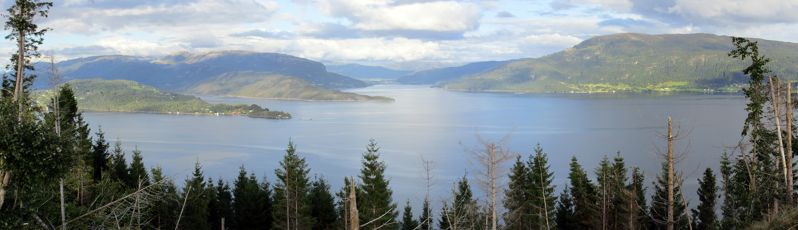
My next goal was Stordalshaugen, in the northeast of Tverråsen. To get there, I passed over another little top in between (without any name?). At times, the terrain is quite steep up there (even though these tops are not high themselves), so choosing your steps carefully is recommended. Once I started to get closer to Stordalshaugen, the forest opened up (due to some heavy forest works at the southeastern side of Stordalshaugen and Høgåsen) and I could enjoy the first major views over Fusafjorden in the south. Nice! :-)
Høgåsen
From Stordalshaugen, I wanted to continue to Høgåsen, i.e., the next top in northeastern direction. The forest work allowed nice views, indeed, but at the same time all what was left from it did not necessarily make hiking easier. Still, it was not very difficult to find a connection to Høgåsen and up there. Again, I enjoyed the view very much! Once on the top of Høyåsen, I continued further over the high ridge (and Asalåsen) until I connected with a basic road, which winds around the ridge, bringing me back in southwestern direction (on the southeastern side of the mountain ridge).
Floget nature reserve
I followed this road until it connected with Eidsvegen, looking basically newly made! There I found a sign, which indicated that it is possible to walk through the nature reserve Floget, right next to the fjord. This was unexpected and better than originally thought (the maps that I had consulted earlier did not show this path!). Thus, turn left (instead of right) on Eidsvegen, following the road downwards to a place called Skavhedlo (the road ends there, but the path through the nature reserve Floget continues). It was interesting to read that hikers were warned to step carefully, since the path through the nature reserve was described as going through very steep terrain. Well, the sign was right and crossing the Floget was nice and exciting (if you are afraid of heights, or have difficulties stepping safely in exposed places, then this path is not recommended to you). Crossing through the nature reserve, I connected to Kilen (very near to where the ferry to Venjaneset stops/starts).
Furehaugen
From Kilen, I continued along a basic road up to Berge, and enjoyed an unexpectedly sweet farming area there, before come out to the road Berge more or less exactly where I had parked. This would have made a nice round, already, but I thought that I could include Furehaugen, as well, on this hike. To get there, I followed a tractor road, which brought me up to the southern side of Lægda. After rounding Lægda on its southwestern side, I turned right, when connecting to another tractor road, bringing me up to the eastern end of Furehaugen. Before actually getting to the saddle, however, I decided to ascend to the ridge via its southern side (this turned out to be signficantly steep and nontrivial; maybe it would have been easier to first go to the saddle and then start walking along the ridge). Once I was on the ridge, following it towards the "top" of Furehaugen was straight-forward, even though there was one surprise, still: Throughout the forest there were clear signs that also cows would roam this mountain (quite unusual!) and when coming down from Furehaugen, after enjoying some evening views from its top, I actually came by one forest cow (kind of strange experience, especially in the evening).
Nordåsen
Before getting back to my car, I decided to also include Nordåsen (in the northeast of Furehaugen). I thus followed some tractor roads until I got close, before I left the road and searched my way through the forest to find the top. Once I had crossed Nordåsen, I then found my way down to an open place on which I also found another tractor road that took me down into the valley, and eventually also back to my car.
Summary
All in all, this was a hike for those, who do not mind to searching their way through the forest (and wilder). While it for sure take more time to traverse the mountain forest without any path, it also shows some sides of the nature, which otherwise remain hidden. Especially the views from Stordalshaugen, for example, but also crossing through the Floget nature reserve, where clearly worthwhile highlights of this hike.
Photos
Selected photos are available as Google photo album.
Useful Resources
See also the related FB-page Hiking around Bergen, Norway.
Petter Bjørstad has a useful page about Furehaugen and a useful page about Tverråsen.
Web page UT.no from the Norwegian Trekking Association recommends a (somewhat) similar hike.


Kommentarer