
Summer evening on Lyderhorn (03.07.2017)

Written by HHauser (Helwig Hauser)

| Start point | Bjørndalstjørna (30m) |
|---|---|
| Endpoint | Bjørndalstjørna (30m) |
| Characteristic | Hillwalk |
| Duration | 2h 00min |
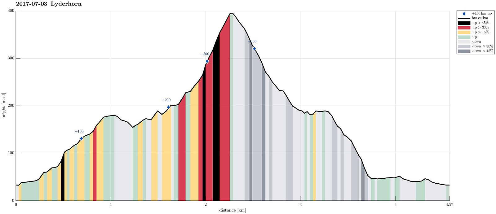
| Distance | 4.6km |
| Vertical meters | 443m |
| GPS |
|
| Ascents | Lyderhorn (396m) | 03.07.2017 |
|---|---|---|
| Skarpafjellet (180m) | 03.07.2017 | |
| Visits of other PBEs | Lyderhornhytten (lokalitet) (396m) | 03.07.2017 |
Trip Summary
We took the car along road 557 towards Bjørndalen, where we parked right next to Bjørndalstjørna. We crossed the double-lane street (Lyderhornsveien) and found a narrow passage that led us up to Bjørndalsbakken. From there, we connected to Sildaberget and between houses 31 and 35 we found the narrow opening, which leads the path that brings one up the steep mountain-side there.
Skarpafjellet
Before actually ascending to Lyderhorn, we first crossed Skarpafjellet in the south of Lyderhorn. Once up the little top, there, one can enjoy some very nice views in all directions.
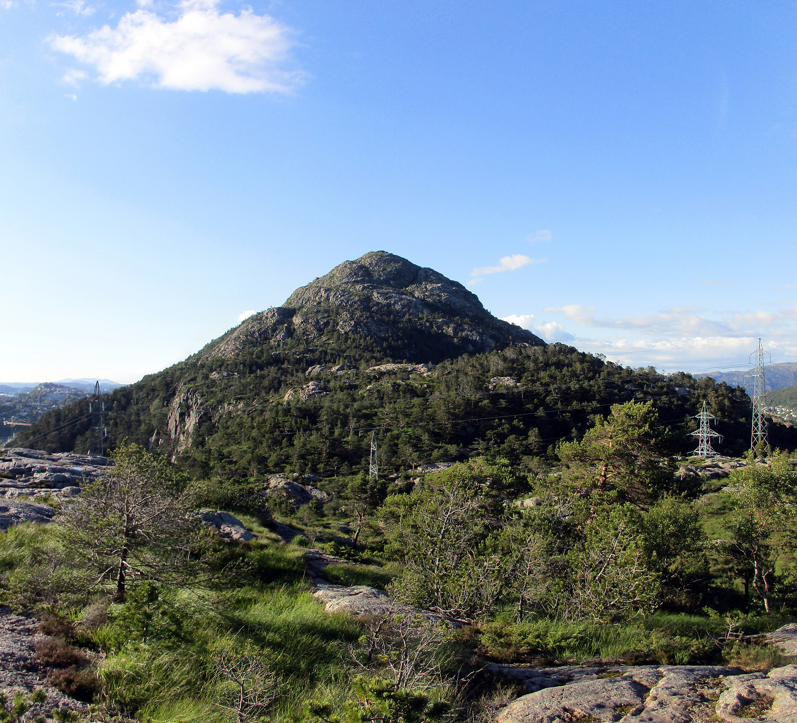
Lyderhorn
In order to get further to Lyderhorn, we descended from Skarpafjellet on its northeastern side, avoiding the very steep side towards Grøvledalen. From the saddle, where also a power line is crossing, we then followed a path, which leads through the forest in the southeast of Lyderhorn. Once on the steep southern slope of Lyderhorn (and above the forest), it is straight-forward to ascend to the top of Lyderhorn (even though this side of Lyderhorn is significantly steep, it still is possible in many places to step up directly towards the top).
Back towards the highway crossing
After some nice minutes on the top of Lyderhorn, we turned back, descending on the southeastern side of Lyderhorn, following a marked path. In the forest, we followed a narrow path, leading into eastern direction, but later decided that we would prefer a better path down. Thus, and instead of directly descending from there, we first crossed over some smaller heights further towards the south, before we connected to a reasonable path that leads down from the saddle to Skarpafjellet (partially underneath the power line). Eventually, this is leading down to the road, which is crossing directly over the eastern portal of the highway tunnel underneath Lyderhorn.
Conclusion
Once back on the road, we followed first Lyderhornveien towards Bjørndalen, before we rounded Bjørndalstjørna on its eastern side (no traffic, thus nicer to walk along). All in all, it is very nice to ascend to Lyderhorn (from all sides, actually), but it may be nicest on a nice summer evening like this one! :-)
Photos
Selected photos are available as Google photo album.
Useful Resources
See also the related FB-page Hiking around Bergen, Norway.
Web page WestCoastPeaks.com provides useful information about Lyderhorn and Ørnafjellet
and also Petter Bjørstad has a page about Lyderhorn.
On Bergentopp 200 there is a page (in Norwegian) about Lyderhorn.


User comments