
Veten i Åsane via Skagen (13.04.2017)

Written by HHauser (Helwig Hauser)

| Start point | Dalabygda (95m) |
|---|---|
| Endpoint | Dalabygda (95m) |
| Characteristic | Hillwalk |
| Duration | 3h 00min |
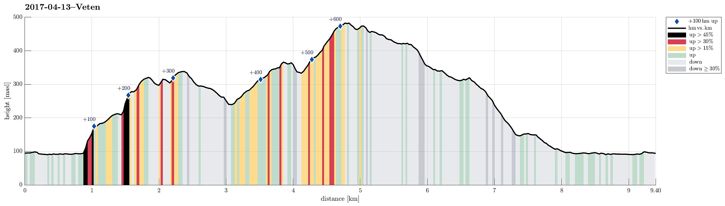
| Distance | 9.4km |
| Vertical meters | 692m |
| GPS |
|
| Ascents | Håkeberget (428m) | 13.04.2017 |
|---|---|---|
| Skagen (342m) | 13.04.2017 | |
| Storsåta ved Veten i Åsane (369m) | 13.04.2017 | |
| Veten i Åsane (486m) | 13.04.2017 | |
| Visits of other PBEs | Dalabygda stengt p-plass (90m) | 13.04.2017 |
| Skagen søyle (339m) | 13.04.2017 |
Trip Summary
Inspired by a recent hike of a colleague, I decided for a tour up to Veten i Åsane today. I found the idea to include also Skagen i Åsane attractive and thus planned for a little round, accordingly.
Getting started
To start, I took the car to Åsane (along E39) and then, near IKEA, I connected to a very narrow, small road, which leads towards Dalabygda in the northwest of Langavatnet (where the old post-path starts to ascend between Høgstefjellet and Veten i Åsane). Next to the few houses there, a parking place has been built as a convenient starting point for hikers along the old post-path.
Glanten, Alteret, Husaberget, and Skagen
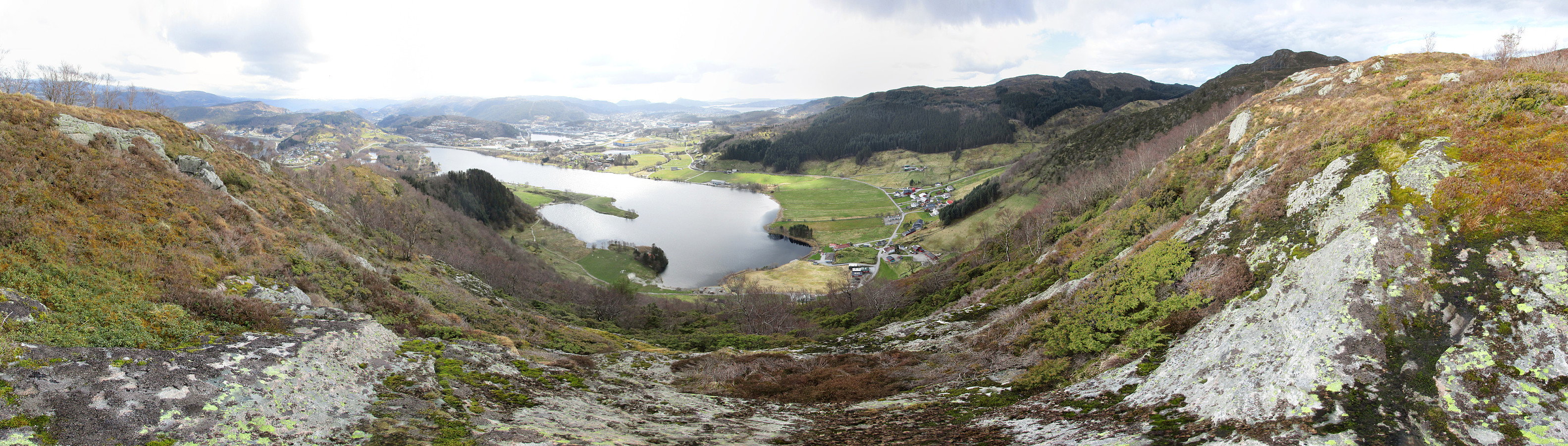
In order to make the ascent to Skagen a little more interesting, I thought that I could try to go there via the smaller hilltops, which one can find between Langavatnet and Skagen, i.e., Glanten, Alteret, and Husaberget. From looking at the map, I already knew that ascending to Glanten, even though small (only about 100 height-meters up), would be a little challenge due to significantly steep slopes on its western and southern side. In order to check, I first continued along a simple field road that is the continuation of the road that I had taken with the car to Dalabygda, connecting along the northeastern side of Langavatnet to Teigland. Sourrounding Glanten on this basically horizontal field road, I watched out for a possibility to get up. After having passed Hellevika (of Langavatnet), I evaluated the (quite steep) southern slope of Glanten a possible route to ascend and thus left the road, starting my hike "for real". :-) Avoiding any major slip, I managed to step up to Glanten without problems and soon started to enjoy some nice views towards the south. From Glanten, I continued in northeastern direction (basically in the direction to Skagen), following the ridge line. Only shortly later, I saw my next challenge, i.e., connecting to Alteret. Also here the ascent was steep (quite steep!), but possible without major problems (I basically followed the line of a stone wall, which runs straight up to Alteret in northwestern direction). Also here, the vertical difference is small (about 100 height-meters, also), so getting up did not take long, after all. From Alteret, again, I gladly enjoyed some nice panoramic views. Instead of walking to Skagen directly from Alteret, I decided to also visit Husaberget. I followed the same stone wall that already guided my ascent to Alteret and got up to Husaberget without any problems (not so steep as Glanten/Alteret). Also Husaberget, as expected, offers a very nice overview over Langavatnet and nearby areas. Then, after all, I thought that it was time to eventually get to Skagen. This little passage (in northeastern direction) turned out to be close to a little bush war (in wet terrain), letting me enjoy it particularly, once I stepped onto the little path which extends parallel to Skagen (southwest of it). Instead of trying a direct ascent to Skagen (quite steep, probably possible without problems, though), I decided to first follow this path a little (in southeastern direction) until I came down to a major stone wall. From there, it was then straight-forward to connect to Skagen, which also offers some very nice views (in almost all directions).
Via Storsåta to Veten
Reading the map at home before leaving, I had decided to try a diagonal connection from Skagen to a path, which leads up to Storsåta, east of Veten, starting at Sæterstøl (I basically wished to avoid a visit to Sæterstøl). My goal was to follow a small valley, which starts at about the point, where several paths meet north of Skagen, and then extends first northwards (somehow diagonally along Veten), before then turning towards the right, eventually meeting the valley, which separates this part from Litlafjellet. Even though I could not see that others would also use this route, I still found my way without difficulties and ended up exactly at the point, where a simple, wooden bridge helps with getting over the little stream, which runs down southwest of Litlafjellet (in southeastern direction). Having met a nice path, there, I followed it (first up to the saddle separating Litlafjellet in the southeast and then further up the ridge in northwestern direction). This path brings on up and close to the top of Storsåta (but really up to the little top itself). In fact, one may wonder, whether it really is necessary to include the actual top of Storsåta (the name is really misleading, since this top is by no means high or prominent). Since I was still curious to catch another nice view from Storsåta, I got to the top through the bushes (not really difficult). Indeed, one can enjoy some nice views from up there, in particular also towards Osterøy. After taking a picture, or two, I completed a small round over the little top of Storsåta, finding my way down on its western side (there, it's steep, and one may prefer to go down in southern direction, getting back to the path there). Soon, I was back on the path and followed it then towards the top of Veten (in northwestern direction).
Veten, Raudnipa, and Håkeberget
Once up Veten (with really nice views---now also towards the north), I decided that it was time to round up this hike (it was not 100% clear, whether the weather would hold). Therefore, I started to descend, following the ridge, which extends southwards from the top of Veten. This brings one over several smaller tops along the ridge, including Raudnipa and Håkeberget (all with nice views). Instead of turning right (in southwestern direction) shortly after Håkeberget, I continued along the ridge (towards Skagen) and connected to the little path, which I had touched for a few meters already when crossing over to Skagen in the beginning. Following this path, passing by Skagen, in southeastern direction, I got to Kyrkeleitet, which was easy and straight-forward to walk down. After a while, I saw a few houses (at the end of Sæterstølvegen) and found my way towards them (on the map, I had seen that from there a path would lead further down to Teiglandvegen). But then, when I actually stepped out to the road between the houses (Sæterstølvegen), I met a (not quite friendly) man, who seemingly had awaited me coming down via Kyrkeleitet already. He made clear that he didn't wish me to hike around there and instructed me to continue along the road (Sæterstølvegen) instead. Since I was not in the mood for any extended quarrel, I simply followed his instruction and took the road further down. Shortly after, I could then connect back to Teiglandvegen and following this road back to my car (coming by the point, where I had left this road earlier).
Conclusion
For me, this hike was interesting and nice, including also a few challenges (steep ascents, stretches without any path, etc.). Clearly, not everyone will appreciate these aspects of non-standard hiking equally much, so therefore, it is recommended to evaluate this first before following this route in detail.
Photos
Selected photos are available as Google photo album.
Useful Resources
See also the related FB-page Hiking around Bergen, Norway.
Web page WestCoastPeaks.com provides useful information about Veten and also Petter Bjørstad has a useful page about Veten.
On Bergentopp 200 there are pages (in Norwegian) about Veten, Skagen, and Storsåta.


User comments