
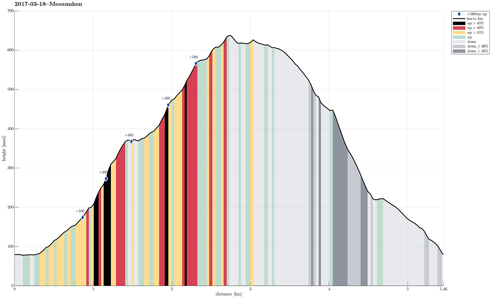
Møsnuken from Tveit (18.03.2017)

Skrevet av HHauser (Helwig Hauser)

| Startsted | Tveit (80moh) |
|---|---|
| Sluttsted | Tveit (80moh) |
| Turtype | Fjelltur |
| Turlengde | 3t 15min |
| Distanse | 5,5km |
| Høydemeter | 593m |
| GPS |
|
| Bestigninger | Møsnuken (639moh) | 18.03.2017 |
|---|---|---|
| Andre besøkte PBE'er | Tysk flyvinge fra 1942 (319moh) | 18.03.2017 |
Trip Summary
Via Fana, we first drove to Osøyro, before we continued along road 137 (in northeastern direction). We passed Heggland and continued to Tveit, where we parked the car near to the point, where the street passes over Spannsteigselva, coming down from Gjemdalsskaret (at the end of our hike, we should come down exactly there, too).
Tveitaberget
Our plan was to ascend towards Møsnuken via Tveitaberget. To do so, we first found a little forest road, which departs from Hegglandsdalsvegen a little southwest of where we parked (i.e., back along the street, which we had come there). This forest road leads upwards (mostly in western direction) and brings one conveniently to a height of about 150mosl. There, after an extended left swing, the road splits into a somewhat more prominent part, leading upwards in northern direction, and a minor part that continues more in western direction. We followed, as planned, the second one, until we reached about 200mosl. There, the path becomes less visible. It turns sharply left and leads (at about the same height ) along the hillside into the valley, which separates the path from Tveitaberget. Climbing over fallen trees, we followed this "path" as long as possible, but found out soon that it indeed ends somewhere there (as indicated on the map!). The terrain is steep and fallen trees do not make progress easier. We knew that ascending towards Tveitaberget would require to cross over the little stream that had carved deeply into the valley that we had entered. After a short consideration, we concluded that switching to the other side of this valley was not reasonably doable. Thus, we turned right and searched for an alternative way up, surrounding some cliffs on their eastern side instead (turning away from the valley). The area there is really steep and ascending further upwards requires a careful choice of a suitable passage (non-trivial, but definitely possible). At time, we needed to use our hands, also, just to be safe.
The crashed German war plane
After having ascended to about 300mosl, the further procedure became easier, even though there was a substantial amount of snow (and no tracks, of course, besides some fresh tracks of deer. Understanding that we had ascended a bit further east than what would have brought us to Tveitaberget, we decided that we could equally well continue and get to the track leading up to Møsnuken directly. We thus continued (mostly in northwestern direction) and came (more or less directly) to the place, where (a) the path from Tveitaberget joins the path between Gjemdalsskaret and Møsnuken and (b) some remains of a crashed German airplane from WWII can be seen. A little board offers a bit of information about this plane crash, including the names of the four German soldiers, who most likely died in this plane crash. Standing there, in the snow, right next to the pieces of this crashed airplane, reading about the died soldiers, brought an unexpected feeling of solemnity with it: suddenly, you find yourself in the midst of some tragic history, with much of the usual distance to it removed (no fences, no monument, just snow-covered pieces of this airplane right next to the path).
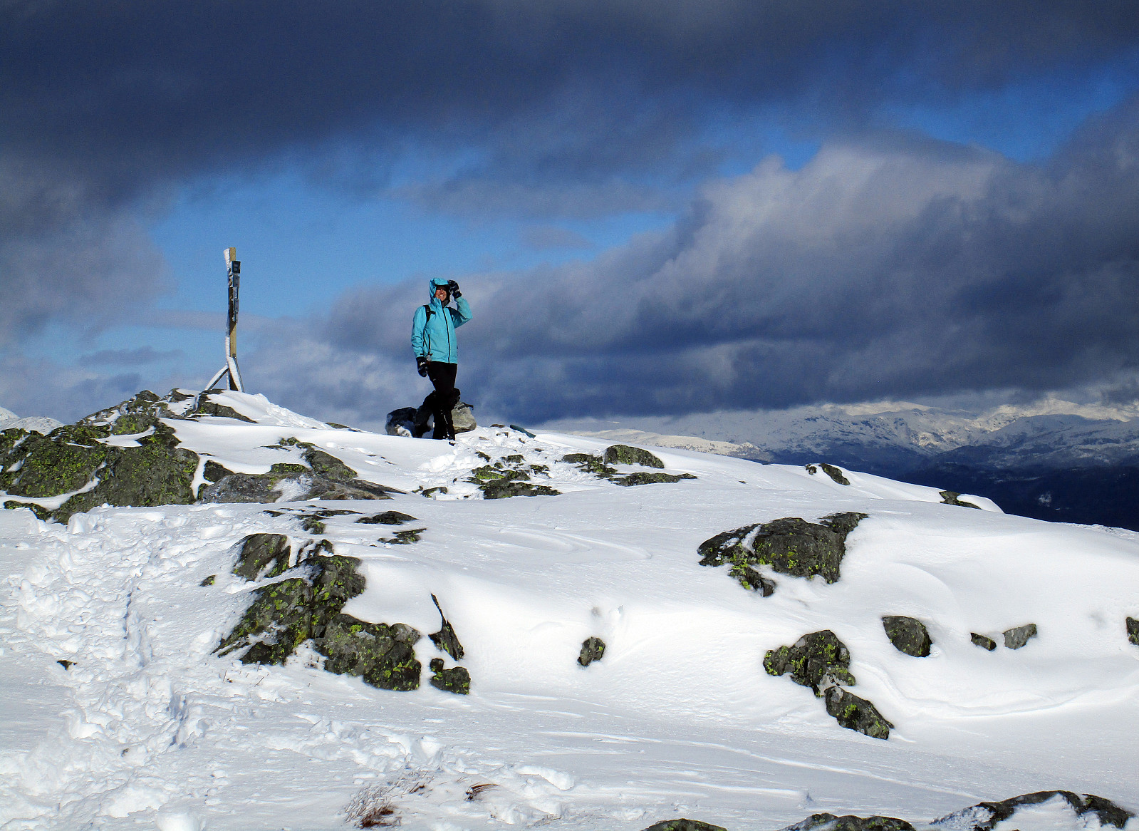
Møsnuken
After a moment at the plane crash site, we continued further (first in southern direction, before then turning more into a western direction) towards Tveitaskaret. The path was basically invisible, because of the snow, but then quite a number of markings could be found, reassuring us that we were still no track! :-) Also, quite funnily, a rabbit, or the like, had hopped quite accurately along the snow-covered path, "leading" us, in a way, towards Tveitaskaret. Once there, we first enjoyed some nice views over Bjørnafjorden, before turning right and upwards towards the path up to Møsnuken. Instead of walking "all the way" towards the meeting point of the paths, we took a little shortcut upwards, connecting directly to the "diagonal", which is also part of the somewhat more popular path up to Møsnuken. Indeed, we then found tracks to one person that had descended along this path a bit earlier. Not only, because we had used this path before (without snow, though), but also because of these tracks that came down from Møsnuken, we easily found our way up to the top of Møsnuken. And what a great experience, really! A piece of snow heaven! Good weather (even some sun, in between!) and amazing views in all directions. We really enjoyed these minutes on the top of Møsnuken (it was quite windy, as often on Møsnuken, and not exactly warm, so we did not stay there for very long).
Back over the top
Since hiking through the snow was quite OK (very little deep snow, but mostly semi-hard, semi-deep snow), we decided to not descend the way we had come up, but instead search a way down that stays "on top" as long as possible. Thus, we first connected to Gjelhaugen (north of Møsnuken). From there, we continued "over the ridge", turning slowly into a more eastwards oriented direction (towards Steinsetra (avoiding Gjelet further in the north). It was good, actually, to not get too much north, but instead prefer the lines down that were a bit more to the east, instead. We even came by a few small stone cairns (very small) that indicated that other had been there, before. :-) At Steinsetra, and more or less as soon as we met the first little trees, we understood that a decision was necessary (some parts over there were too steep to use). So instead of continuing further towards Gjemdalsskaret directly (in eastern direction), we decided to instead connect more directly to the path, which we expected a bit further down, south of where we were. We found a place, where descending was possible (even though in uneven terrain and also quite steep). With the necessary care, we found our way down and connected to the path, as expected, at about 350mosl. From there, then, it was easy and straight-forward to use the path, which brings one down into Gjemdalsskaret (a bit south of Gaupeskarkulten). The last (small) challenge was to cross over Spannsteigselva, before getting to the forest road, which brings one down to Hegglandsdalsvegen.
Conclusion
While parts of this hike were off-track (and also through quite steep places, occasionally), we really enjoyed the fantastic snow world on Møsnuken. It was just right with the amount of snow that hiking was still possible (very well) and still this amazing impression of being in the midst of snow-covered mountains was at its best. Wow! :-)
Photos
Selected photos are available as Google photo album.
Useful Resources
See also the related FB-page Hiking around Bergen, Norway.
Web page WestCoastPeaks.com provides useful information about Møsnuken and Tyssdalsfjellet
and also Petter Bjørstad has a useful page about Møsnuken.
Web page UT.no from the Norwegian Trekking Association recommends another hike up and down Tyssdalsfjellet (Møsnuken).


Kommentarer