
Sandviksfjellet, Rundemanen, Blåmanen, and Midtfjellet (26.02.2017)

Geschrieben von HHauser (Helwig Hauser)

| Startpunkt | Sandvikstorget (5m) |
|---|---|
| Endpunkt | Olav Kyrres gate (10m) |
| Tourcharakter | Bergtour |
| Tourlänge | 3h 45min |
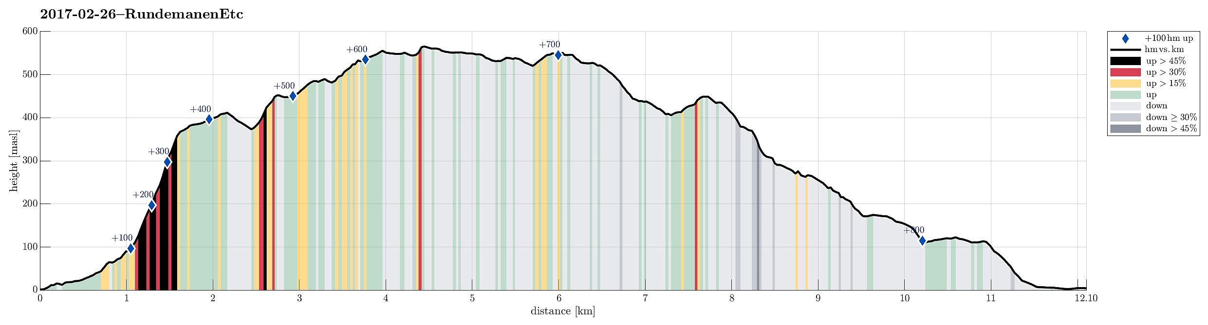
| Entfernung | 12,1km |
| Höhenmeter | 818m |
| GPS |
|
| Besteigungen | Blåmanen Øst (554m) | 26.02.2017 |
|---|---|---|
| Søre Midtfjellet (452m) | 26.02.2017 | |
| Rundemanen (568m) | 26.02.2017 | |
| Sandviksfjellet (417m) | 26.02.2017 | |
| Øst for Store Tindevatnet (543m) | 26.02.2017 | |
| Besuche anderer PBE | Bergen Radio Maskinhus (552m) | 26.02.2017 |
| Bergen Radio Stasjonsbygning (553m) | 26.02.2017 | |
| Blåmansveien utsiktspunkt (440m) | 26.02.2017 | |
| Brannmannshytten (ruin) (448m) | 26.02.2017 | |
| Café Knatten (211m) | 26.02.2017 | |
| Fjeldborg (ruin), Sandviksfjellet (397m) | 26.02.2017 | |
| Fjellhytten (451m) | 26.02.2017 | |
| Fredheim (ruin) (372m) | 26.02.2017 | |
| Heimtun (310m) | 26.02.2017 | |
| Hus vest for Rundemansmasten (546m) | 26.02.2017 | |
| Kronborg (ruin) (551m) | 26.02.2017 | |
| Søre Midtfjellet utsiktspunkt (440m) | 26.02.2017 | |
| Tindeborg (529m) | 26.02.2017 | |
| Trollborg (ruin) (404m) | 26.02.2017 |
Trip Summary
We took bus #4 and got off at stop Sandvikstorget. We found a way up to Amalie Skrams vei and continued along Uren to get further up. Eventually, we went Sudmanns vei up to its end. There, one can sneak through some openings in order to get further up (to Fjellveien). Once on Fjellveien (there), it is only a few meters, before one can start with Stolzekleiven.
Stolzekleiven and Sandviksfjellet
We then ascended along Stolzekleiven in order to reach Sandviksfjellet. Clearly, many others were also out in order to test their strengths on Stolzekleiven. It is quite impressive, one must admit, with its many steps and the steep ascent to the top end, roughly 300 height meters above Fjellveien. One their, we continued off-trail along the (gentle) ridge in order to get to the actual "top" of Sandviksfjellet (a place, usually skipped along one of the many paths that run nearby). A few minutes later, we came to Sandviksfjellet (quite a contrast: while many did exercise up Stolzekleiven it seemed that none had continued to Sandviksfjellet). We enjoyed the good views from up there, before we continued (next goal: Rundemanen).
Rundemanen
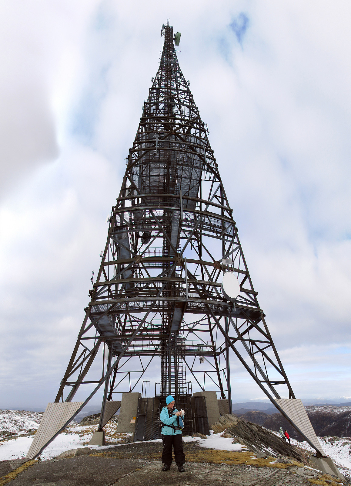
From Sandviksfjellet, one can use a simple path (mostly in eastern direction), but it is recommended to cut short the last bit (about half of this path) in order to get directly to the dam that hold back Storevatnet (in the southeast). There, it is straight-forward and easy to cross over. A path leads upwards in a little gully, before it turns left (in northern direction) and further up from there. After a few minutes, one gets up to about 450mosl, where the terrain becomes a little flatter (for a while). We followed a path that brought us to the hill-side, leading further up towards Rundemanen. After a while, our path continued in a way parallel to a power line, which connects to the few buildings near the tower of Rundemanen. Once there, it was only a short stretch over to the actual top of Rundemanen (with the impressive mast on it, over 100m high!).
Blåmanen (Blåmanen øst)
From the top of Rundemanen, we continued in southern direction, passing by Lille and Store Tindevatnet on their eastern side. The path follows a ridge in parallel to these lakes. At the very southern end of Store Tindevatnet, one gets to a dam, which holds back the larger of the two lakes. This is also the point, where we crossed over and continued by ascending into the direction of Blåmanen. All others had seemingly chosen other routes, meaning that we needed to find "the path" in untouched snow. Before actually getting to Blåmanen (Blåmanen øst), we first crossed over a similarly high "top" right north of it. Eventually, we stood on the small top of Blåmanen øst (seemingly not a top which is frequented a lot).
Midtfjellet and Bergen
From Blåmanen (Blåmanen øst) we first connected to the path, which leads up to "the other Blåmanen" (Blåmanen vest), then followed this path for a little bit down (mostly in southern direction), before we continued further down along the ridge (instead of taking the more winding path). After this short-cut via the ridge, we got back on the path. We briefly enjoyed some views over Svartediket further below, before we continued into the direction of Midtfjellet. At Søre Midtfjellet, we stopped for a moment at Fjellhytten. Non-pleasant winds motivated us, however, to continue rather soon. We took the path downwards, which connects to Heimtun (via Langetoen). From there it is then only a few steps down to the major path, which leads up Starefossfjellet from Knatten. This path brought us down to Starefossveien. From there, we took Starefossbakken to get further down, and via two smaller connections we quickly came down to Fjellveien. We then followed Fjellveien until we found a steep connection downwards, leading us to Skivebakken. Once down Skivebakken, we were back in the center of Bergen and close to the bus stop at Olav Kyrres gate.
Summary
All in all, this was an interesting hike. While it was close to Bergen, still most of this hike was along less used paths (with Stolzekleiven being a prominent exception, of course!). With about 12km and clearly over 700 height meters up, this hike is also a little exercise. The weather was at least non-rainy (it was mostly cloudy and also quite windy), leading in total to a very positive hiking experience! :-)
Photos
Selected photos are available as Google photo album.
Useful Resources
See also the related FB-page Hiking around Bergen, Norway.
Web page WestCoastPeaks.com provides useful information about Rundemanen and Blåmanen.
On Bergentopp 200 there is a page (in Norwegian) about Sandviksfjellet.


Benutzerkommentare