
Gardafjellet and Signalen (11.02.2017)

Geschrieben von HHauser (Helwig Hauser)

| Startpunkt | Ulveset (35m) |
|---|---|
| Endpunkt | Ulveset (35m) |
| Tourcharakter | Bergtour |
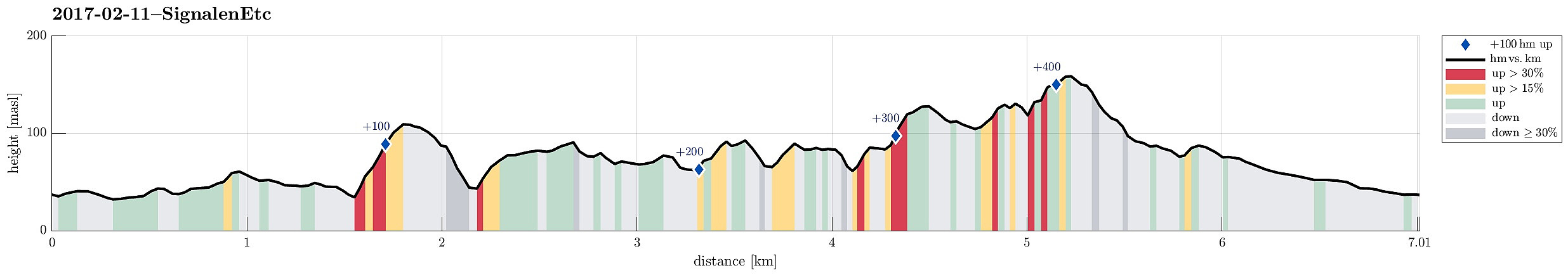
| Tourlänge | 3h 00min |
| Entfernung | 7,0km |
| Höhenmeter | 430m |
| GPS |
|
| Besteigungen | Gardafjellet (112m) | 11.02.2017 |
|---|---|---|
| Signalen (164m) | 11.02.2017 |
Trip Summary
We took road #555 towards the west of Bergen, crossing Sotrabroen and the tunnel near Kolltveit. Turning left, right afterwards, we continued on road #555 towards Fjell, where we turned right, taking road #559 further westwards. At Ulveset, very near to the school there, we parked and started to hike.
Getting started
We first followed a small road called Trippevegen in northeastern direction, up to a relatively sharp turn. There, we found the path, which leads further north (instead of following the road, which extends towards the west). We followed this path to a point, which is marked with "Litlestengelen". From there we continued without a path in northeastern direction, heading towards Gardajellet (a bit north of Kvernavatnet). Hiking was all easy (mostly because the ground was conveniently frozen almost everywhere!), but crossing the fences (without treating them badly) required a little bit of back and forth in some places.
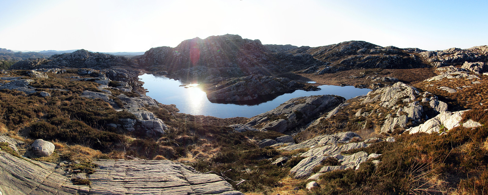
Gardafjellet
We crossed over Ulvesetdalen just north of Kvernavatnet in order to approach Gardafjellet. This little height is no real challenge for hikers, but it has a few (small) cliffs on its western side. It is easy, however, to always find a way up and towards the top. A few minutes later, we arrived at the top and enjoyed some nice views from up there (both "inlands", via Fjell towards Pyttane, Liatårnet, and nearby heights, and also northwards, towards Knappskogsfjellet, and westwards, towards Signalen). Next, we descended from Gardafjellet just a little north of where we ascended, overlooking Ulvesetdalen from up there.
Approaching Insta Skålvikvatnet
Back down we crossed Ulvesetdalen towards the west and ascended to some moderate heights, which extend into a northwestern direction from there.
We followed these heights in order to find a place from where we could look down to Insta Skålvikvatnet. A little more than half-way there, we had a funny meeting with a large bunch of sheep (who seemingly thought that we would have something good for them and thus hurried towards us). We then crossed (the frozen) Bjørkemyra and ascended to a small top north of this area, providing us with the first major view down to Insta Skålvikvatnet.
Connecting to Signalen
We then continued (parallel to Insta Skålvikvatnet) to another small top, from which we enjoyed an even better view over Insta Skålvikvatnet, before we decided that we would cross over to Signalen "directly" (instead of making a larger detour before). Therefore, we then followed a mostly southwestern course, crossing Blombotnen, that would bring us towards Signalen, a bit north of Nordsta Rotavatnet. After some up-and-down hiking, we arrived at Skjenhaugen, which offers nice views (in particular across Skjenavatnet and towards the there already quite near Signalen).
Signalen
We passed by Skjenavatnet on its eastern side, heading south and towards Signalen. Signalen has a steep (partly overhanging) cliff on its northern side, which is quite impressive (in particular from below) and it is not possible to ascend to Signalen wheresoever. We first took a look towards the west from right underneath this cliff, seeing the North Atlantic in the distance, before we headed back in order to find an easier spot to ascend Signalen (on its eastern side). After a little back and forth, we then found a nice and safe way to completing our (short) ascent to the top of Signalen.
Back to Ulveset
From the top of Signalen, we first descended in southeastern direction, getting down to some lower area (south of Jamnhaugen). We continued to cross "diagonally" towards Ulveset, crossing another small valley southwest of Rotavasshaugane. From there, we just walked in southern direction until we came to an area, where multiple new houses were/are built (the road, which we arrived at, is called Kviterinda, connecting to Halsvardtjørna a little further south). From there, we basically followed the road(s) to get back to our car near the school of Ulveset.
Summary
All in all, this was a very nice winter hike. The weather was excellent and the ground was (mostly) frozen, which made hiking "through the wild" (without a path) quite a bit easier than under "normal, i.e., wet conditions".
Photos
Selected photos are available as Google photo album.
Useful Resources
See also the related FB-page Hiking around Bergen, Norway.
Petter Bjørstad has a useful page about Signalen.
Web page UT.no from the Norwegian Trekking Association recommends a different hike up Gardafjellet (from Fjell) as well as another (also different) hike up Signalen.


Benutzerkommentare