
Anekletten on Toftøyna (29.01.2017)

Written by HHauser (Helwig Hauser)

| Start point | Junction Husdalen/Toftøyvegen (35m) |
|---|---|
| Endpoint | Junction Husdalen/Toftøyvegen (35m) |
| Characteristic | Hike |
| Duration | 2h 00min |
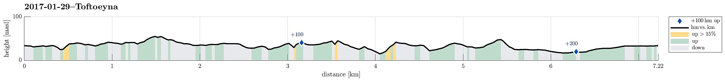
| Distance | 7.2km |
| Vertical meters | 217m |
| GPS |
|
| Ascents | Anekletten (60m) | 29.01.2017 |
|---|
Trip Summary
I drove westwards from Bergen and over to Sotra, where I turned right (and northwards), following road #561, first through Knappskog and then through Ågotnes. A bit further north, I passed over Misje, before connecting to Toftøyna. There, I drove almost to the very north of this little island (near Torsteinsvik) and parked the car right where a little road called Husdalen connects with Toftøyvegen (road #561).
Getting started, finding the trail
On the other side of the street (on the eastern side), a path extends from the main road, leading eastwards. When crossing over a little dip, that connects to Orrdalsvatnet further south, I did not immediately see the continuation of the path and followed (instead) another path, which leads in northeastern direction. I followed this path until an area, where maybe some scouts are maintaining a place (for camping?). There, I decided to turn around in order to connect with the path towards Anekletten, which I had left before. Instead of walking back the path that I had used before, I stepped "through the wild" (quite OK, but wet) and found the path to Anekletten near Orrdalsåsen.
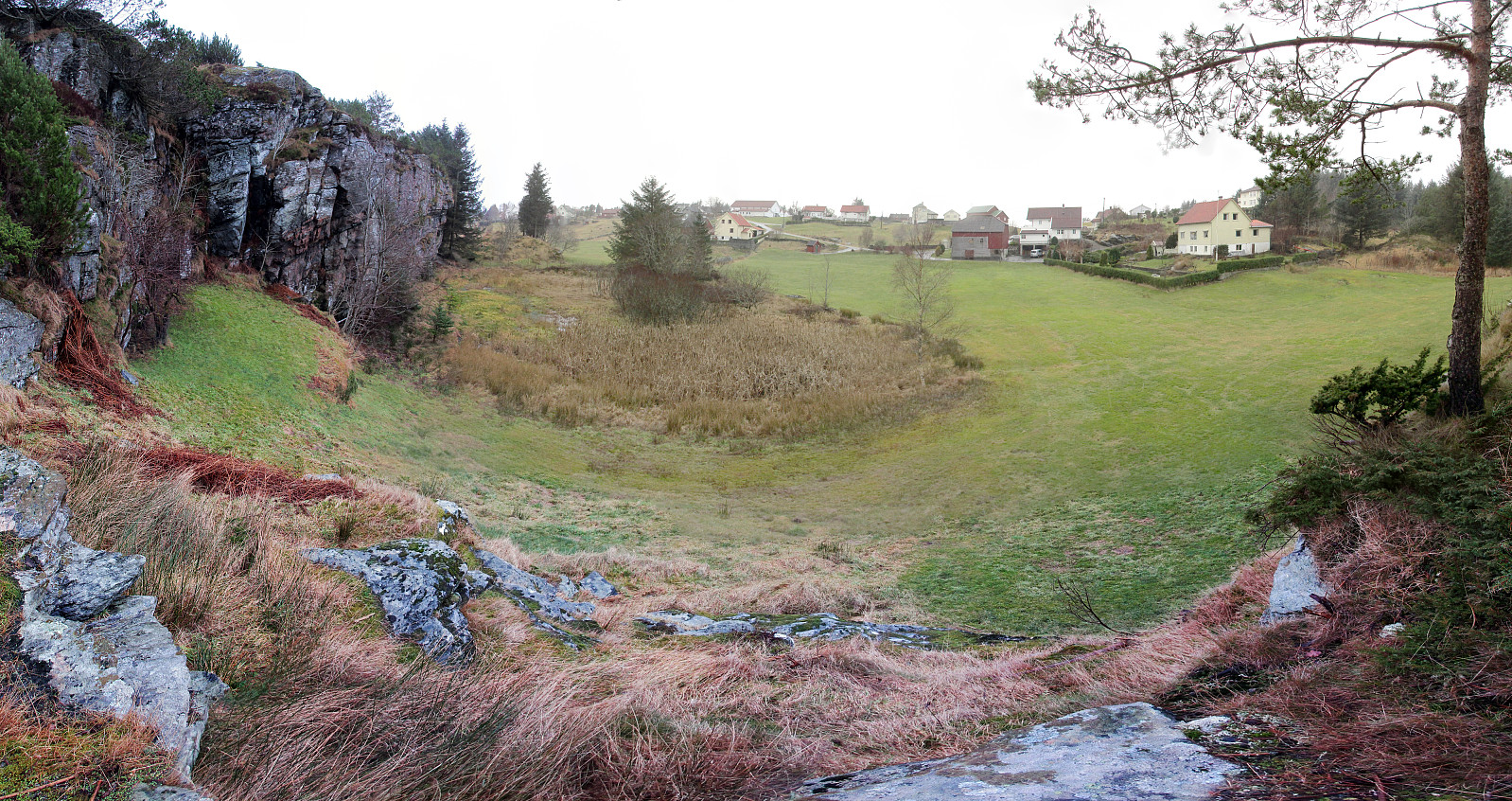
Anekletten and Breivika
From there, it is only a few minutes to the "top" of Anekletten (quite a cliff on its western side, but not really high). From there, I followed the path southwards (into the direction of Breivika). At Breivika, one ends up in an array of cabins, with nice paths in between. After getting through, there, I came to the parking place for these cabins. There, I took a photo of Midtvatnet, before I followed the road further south.
Kvernhusvika and Nesekletten
At the junction north of Norlavatnet, I turned left (eastwards) and followed the road, which connects to Kvernhusika. I left the street for a short bit, taking another photo (this time of Nordlavatnet). I then crossed over at Kvernhusvika and ascended to Nesekletten from there (just a few meters up). In order to continue, I had to find a way down on the western side of Nesekletten (non-trivial due to cliffs on the western side). I followed a stone barrier northerwards and found an opening, which brought me on a "path" that is good to connect to Raunholevegen at Vik. I then walked up there (Vikabrekka) and got back to the main road in just a few moments.
Back to the car (along the main road)
I then decided to complete my round (instead of adding another detour, for ex., to Stegeviksåsen) and started to walk northwards along Toftøyvegen (road #561). I somehow was still adventurous and hoped that I could find a connection "through the wild" (instead of walking along the main road). This brought me to a little micro-top, just south of Toft, from where I enjoyed a good view in almost all directions (getting up there was not exactly trivial, because it was a bit steep and since everything was wet, the ground was partially slippery). Eventually, I thought that this was a good end to the overall hike. Therefore, I found my way back to the main road and then simply walked back to the car along of it (not particularly nice, but OK as a back-to-the-car part).
Summary
Even though I did not get overly excited about this hike, to be honest, I still enjoyed feeling the winds and the waters (both from below and from above). :-)
Photos
Selected photos are available as Google photo album.
Useful Resources
See also the related FB-page Hiking around Bergen, Norway.
Web page GodTur.no describes a similar hike as well as also web page Sprekere.no (similar hike).


User comments