
Tveitakvitingen from Tveita (09.10.2016)

Written by HHauser (Helwig Hauser)

| Start point | Bratthus, Indre Tveita (60m) |
|---|---|
| Endpoint | Bratthus, Indre Tveita (60m) |
| Characteristic | Hillwalk |
| Duration | 7h 00min |
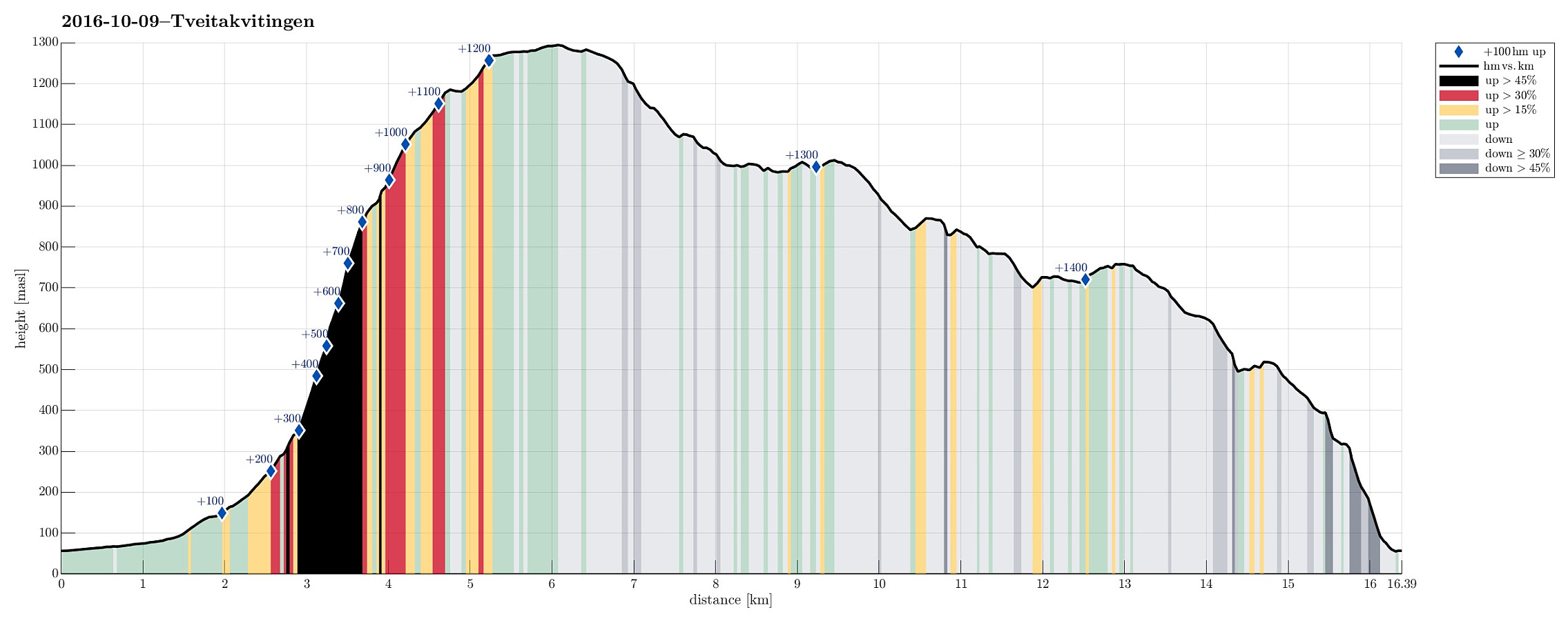
| Distance | 16.4km |
| Vertical meters | 1,473m |
| GPS |
|
| Ascents | Tveitakvitingen (1,299m) | 09.10.2016 |
|---|
Trip Summary
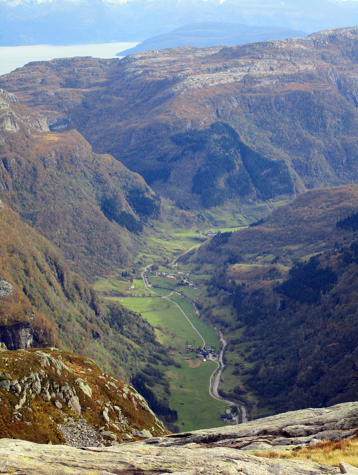
We took E16 from Bergen to Trengereid, then following road number 7 to Samnanger, before changing over to road number 48 right after Hagaåstunnelen. We passed through Eikelandsosen and continued to Holdhus, where we changed to a small road, which would lead us into the Tveita valley. Once there, we continued almost all the way in and parked near Bratthus, close to Indre Tveita. From there, we walked the rest of the road into the end of this nice valley, passing the last farm at Brekka soon after. The way continues into Tveitaskaret, where it becomes steep very soon (but easy to hike---mostly, because a gravel road has been constructed---probably to help maintaining a small power station that was opened in Tveitaskaret in 2009). At the end of the gravel road, one can further ascend through Tveitaskaret---or enter Dyrastegen, right under the impressive cliff-side of Tveitakvitingen, as we did. One starts to ascend steeply over grass right towards the cliff, before then---right under the cliff---turning right and continuing into a diagonal passage that winds around the high cliff in eastern direction. In most places, it is straight-forward to ascend through this part (Dyrastegen)---only occasionally, one needs to use the hands in addition (not problematic). It is, however, important to carefully choose the path---seemingly there are also some dead ends, which one should avoid for obvious reasons. Generally, it worked well for us, following a route, which is more on the outer (southern) side of Dyrastegen than on the inside. Especially in the upper-most part of Dyrastegen, it seems recommendable to stay more in the middle of the passage, than moving too close into the cliff. At the top of Dyrastegen, about 900mosl, one enjoys impressive views---mostly in southern direction. To continue further up, towards the top of Tveitakvitingen, we chose to follow a bow-shaped route, starting almost in western direction (directly above the cliff-face) and then turning more and more into a northern course. Eventually, we took a route, which lead us upwards, slightly below Kvitingsnasa and Tokeskaret (on the eastern side of this ridge). We stepped upwards towards a top, which for long looked like the top of the mountain (from below), but eventually turned out to be a side-top, almost equally high as the top of Tveitakvitingen. From there, we crossed over to the actual top. During this part of the hike, we stepped maybe half of the time over snow (which was very hard and easy to walk on). The top of Tveitakvitingen did not really impress us so much (as its height of almost 1300mosl would suggest, maybe)---the dramatic ascend through Dyrastegen was definitely much more exciting. Once we had been at the top, we immediately continued towards our descend via the east side of the mountain. In the beginning, we followed a nicely marked trail (with red S-marks), before we somehow lost these marks (or maybe they simply weren't continued). Still, it was straight-forward to find our path further down (it was just necessary to step carefully over all the hard snow and ice). At about 1100mosl, not far from the upper end of Storavasskaret, we understood that there was no short-cut to get down to the ridge, which we had intended to follow southwards and back. Instead, it was necessary to do a significant detour (starting in northern direction, then turning right). Once we were down and below some major cliffs, there, we continued in southern direction (towards Storavasseggene and Osadalseggane). The hike over these heights is really very nice (with great views over Hardangerfjorden in the east and south). Since time was pressing (we recognized that soon it will become darker and eventually dark!), we hiked in fast velocity further south. The nicely marked path leads mostly on the eastern side of this ridge (offering many great views!), surrounding also Osadalseggane on their outer, eastern side. Our plan was to get into Bratthusdalen, but we somehow missed the right point, where the path into this valley is separating from the path that leads further south, on the eastern side of the ridge. Once we were at the eastern side of Tokenuten and even though it was getting darker and darker, we decided that we still wanted to get back onto the right track (though Bratthusdalen). We crossed over and found our way down into Bratthusdalen without major difficulties---the path, however, which leads through there, is hard to find (mostly not visible), and only very few markings are to be seen (we only saw two or three T-marks along the whole path through this valley). We managed to find the path through the major S-curve that leads down into Braahusbotnen, but then it became difficult. Still relatively high up in this valley and without a path that was easily seen, it became so dark that we finally had to improvise. With the help of the map of the UT.no app on the phone, we somehow followed the main course of the path (where it was supposed to be, even though we were mostly off-trail at this point in time, already---probably somewhere near to the path, though). Eventually, we gave up on searching the path and descended through the (steep) forest, step by step. Since seeing was difficult, we basically took this descend step by step, holding onto trees, etc.---clearly not a way to proceed, if you have the choice! Fortunately, we managed to get ourselves into some terrain, which wasn't all that steep anymore after a while, seeing the upper-most house in the valley somewhat close. Eventually, we made it back to the road and our car---feeling substantially relieved to have managed this clearly out-of-normal hiking in the dark. Lesson learned? We should have started earlier, first, and then also packed our head-lights, of course!
Photos
Selected photos are available as Google photo album.
Useful Resources
See also the related FB-page Hiking around Bergen, Norway.
Web page WestCoastPeaks.com provides useful information about Tveitakvitingen and Høganovi and also Petter Bjørstad has a useful page about Tveitakvitingen.


User comments