
Høgafjellet (21.08.2016)

Skrevet av HHauser (Helwig Hauser)

| Startsted | Osvatnet parking (90moh) |
|---|---|
| Sluttsted | Osvatnet parking (90moh) |
| Turtype | Fjelltur |
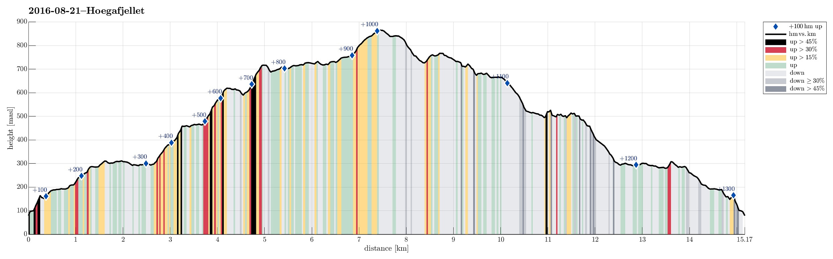
| Turlengde | 5t 45min |
| Distanse | 15,2km |
| Høydemeter | 1300m |
| GPS |
|
| Bestigninger | Helldalsfjellet Øst (719moh) | 21.08.2016 |
|---|---|---|
| Høgafjellet (868moh) | 21.08.2016 | |
| Høgafjellet Nord (770moh) | 21.08.2016 | |
| Andre besøkte PBE'er | Osvatnet p-plass (75moh) | 21.08.2016 |
| Øvrebotnen foss (440moh) | 21.08.2016 |
Trip Summary
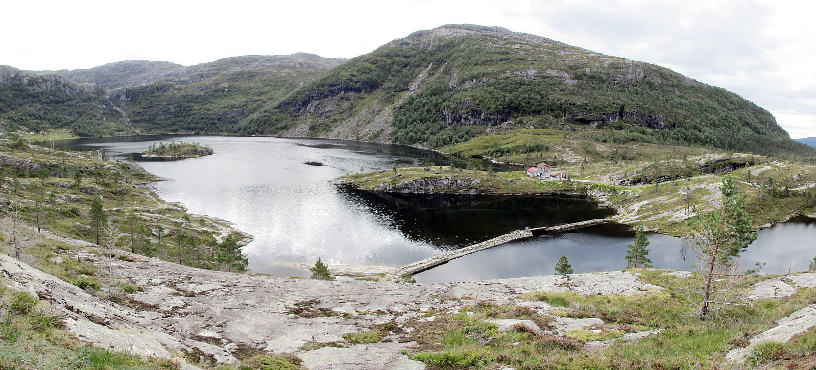
We took the car to Osterøy and there to Tysso, where we followed a narrow road up to Osvatnet, parking at the end of this road, right next to the power station house. We knew already that the old route via the many wooden stairs right next to the water pipe that leads down to the power station house was closed and we followed the alternative route, which first leads into the valley of Kupelva, right underneath Preikestolen. All the efforts that were made to make this track welcoming and easy to go are highly appreciated! Near some moor, right underneath Preikestolen, the path splits and the ones, who wish to ascend towards Høgafjellet, take the path to the right, turning southwards. Via some stairs that help through a small, narrow valley, one gets up to the level of Nedra Botnavatnet. Once there, the path leads (more or less) level eastwards, always on the northern side of Nedra Botnavatnet, until one reaches Tyssebotnen, i.e., a few buildings that previously were a farm, at the northeastern end of Nedra Botnavatnet. From there, the path leads diagonally upwards until one reaches a waterfall that is only a few meters underneath the dam of Øvrebotnen. The old bridge, that seemingly collapsed at some point, was replaced with a nice, new bridge, and stepping upwards to the dam of Øvrebotnen is no longer a challenge. At Øvrebotnen, we decided to turn right (instead of left as the main path does) in order to start with a round-hike around Øvrebotnen. We entered a pretty straight valley, which extends from Øvrebotnen upwards towards Litlafjellet in southwestern direction. Even though we could not see any sign of any path in this valley, it still was nicey doable to step through this valley upwards (we chose to ascend on the eastern side of the small stream in the middle of the valley and this worked out very well). After about half of the ascent, right after having passed a small, enlongated lake, the terrian became a slightly bit more challenging---still, it was straight-forward to progress and soon we had reached the very end of this valley, leading steeply up to Litlafjellet. Up there on Litlafjellet, the surrounding changes substantially. A lot of small lakes interleave with rocks that are easy to walk over. We had seen on the map that ascending towards Høgafjellet seemed recommendable from the southwest and thus we crossed Litlafjellet in southeastern direction, avoiding the cliffs on the western side of Høgafjellet. We found the yellow-marked path that leads up to Høgafjellet and soon we ended up at the top (the highest top of Osterøy). We enjoyed the views in all directions and continued towards the north. Stepping down from Høgafjellet, we approached Høgaheimshytta, but instead of walking by it, along the path, we decided to cross over the little hill behind it. From up there, we enjoyed new views, in particular towards the west and over Øvrebotnen. Instead of going back from there and down to the path near the hut, we explored the opportunity to get back to the path, while heading further north. For one moment, this turned out to be non-trivial (because of some cliffs that were too high) so that we had to walk a little round to proceed (no problem, really). After a few minutes, we were back to the path and followed it then, further circling Øvrebotnen, far down in the valley. After a while, we turned left and descended towards a hut that stands quite high above Øvrebotnen (but still underneath the highest cliffs). From there, the path leads "diagonally" along the hillside downwards, connected evetually to the dam of Øvrebotnen. It's recommended, however, to carefully follow the path in this part, since the terrain is uneven and crossing over some of the drop there may be non-trivial, when ignoring the path. Once back to the dam, we basically followed the same path down that we had taken up already in the beginning. All in all, this was a fantastic hike on wonderful and wild mountain-landscape. It is highly recommended to explore this part of Osterøy (but sufficient time should be calculated for the entire hike).
Photos
Selected photos are available as Google photo album.
Useful Resources
See also the related FB-page Hiking around Bergen, Norway.
Web page WestCoastPeaks.com provides useful information about Høgafjellet and also Petter Bjørstad has a useful page about Høgafjellet.
Web page FotTurer.com recommeds a similar hike up Høgafjellet.


Kommentarer