
Sveningen from Hausdalen (12.06.2016)

Geschrieben von HHauser (Helwig Hauser)

| Startpunkt | Hausdalsvegen 425 (70m) |
|---|---|
| Endpunkt | Hausdal parking (95m) |
| Tourcharakter | Bergtour |
| Tourlänge | 6h 30min |
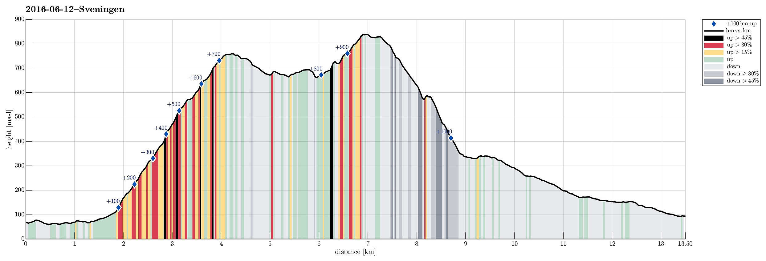
| Entfernung | 13,5km |
| Höhenmeter | 1.037m |
| GPS |
|
| Besteigungen | Sveningen (842m) | 12.06.2016 |
|---|---|---|
| Søtefjellet NV (762m) | 12.06.2016 | |
| Besuche anderer PBE | Hausdalen parkering (94m) | 12.06.2016 |
Trip Summary
This time, we had two cars, so we parked one at the very end of Hausdalen (where Brekkedalen starts). We then took the other car to get to our starting point, a little further out Hausdalen (near Samdalsvatnet, Tømmervika, Straumsrinden, Hausdalsvegen 425---about 3.4 km away from the parking at the very end of Hausdalen). This start point for the hike is not 100% obvious and one needs to know, where to leave the street in Hausdalen. One then drives just a few meters up a gravel road, before there is space for two or three cars on the left side. From there, we followed the forrest road, first over Straumsrinden (passing by Samdalsvatnet). On its southern / southwestern end, one uses two bridges to get over the stream that continues further out Hausdalen. Only shortly after, one crosses Sagelva, which streams into Samdalsvatnet, there, on a simple construction of two large concrete pipes. One the other side, we quickly came to the one point, where another bridge crosses over Sagelva (in southern direction). There, we continued to the left (not taking this bridge) and started to round the northern part of Ulvvatnet (towards Hisbotn). The path is actually well visible there, also when turning left (before getting close to Hisbotnelva) and starting the ascent towards Søtefjellet from there. After first walking through the forrest for a bit, the path quickly becomes steeper, following a prominent and clear ridge north of Hisbotnelva. Once there, the whole ascent to Søtefjellet becomes straight-forward and easy to find (even though the path not always is 100% visible). From Søtefjellet, we descended to Langetjørnane, where we enjoyed a nice hiking break. From there, we continued our hike towards Sveningen. Even though the path is not always 100% visible, it's still straight-forward (and upwards) to get there (one can basically choose, where to step). From Sveningen, we continued in northeastern direction in order to start our descent towards the upper part of Brekkedalen. We followed the ridge down, which is basically oriented towards Sauafjellet. Somewhere about half-way down, one needs to see the place, where the path switches from one ridge (a little further west) to the neighboring ridge (a bit further to the east). Once on that side, it's straight-forward to step down and meet the hills, which border Litla Brekkevatnet on its eastern side. Following the path there, leads directly to the gravel road that comes up there through Brekkedalen. From there, it's basically an easy walk down Brekkedalen, following the gravel road. All in all, this route up and down Sveningen is really nice (without two cars, it's maybe a little boring to walk the 3.4 km on the road through Hausdalen between the starting point and the end point).
Photos
Selected photos are available as Google photo album.
Useful Resources
See also the related FB-page Hiking around Bergen, Norway.
Web page WestCoastPeaks.com provides useful information about Sveningen, Søtefjellet, Sauskolten, Rindafjellet, and Midtsæterfjellet
and also Petter Bjørstad has a useful page about Sveningen.


Benutzerkommentare