
Indrafjellet from Liaskjæret (09.04.2016)

Written by HHauser (Helwig Hauser)

| Start point | Liaskjæret (30m) |
|---|---|
| Endpoint | Liaskjæret (30m) |
| Characteristic | Hillwalk |
| Duration | 3h 30min |
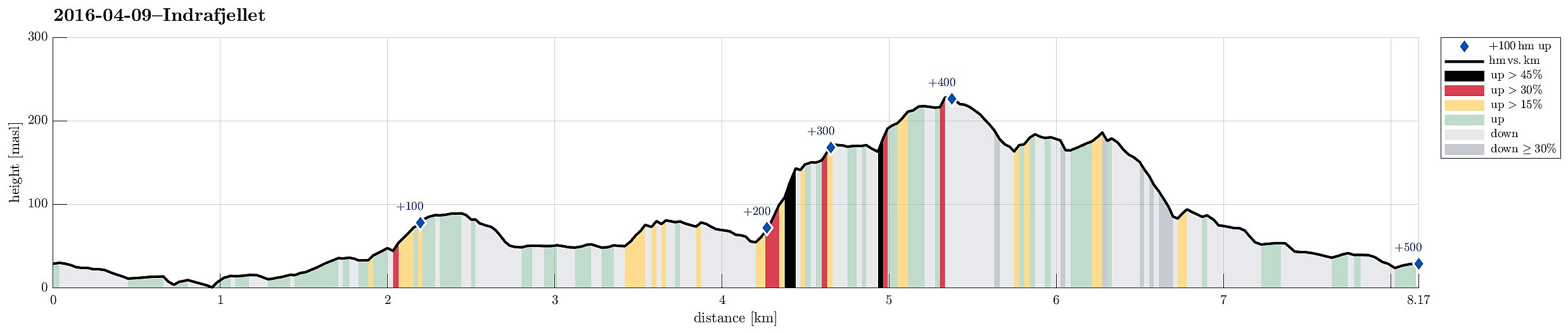
| Distance | 8.2km |
| Vertical meters | 497m |
| GPS |
|
| Ascents | Haganesfjellet (232m) | 09.04.2016 |
|---|---|---|
| Kattafjellet (191m) | 09.04.2016 | |
| Visits of other PBEs | Alteret (155m) | 09.04.2016 |
| Hansafjellet (95m) | 09.04.2016 | |
| Jonsokhaugen parkering (30m) | 09.04.2016 | |
| Lundaneset (50m) | 09.04.2016 |
Trip Summary
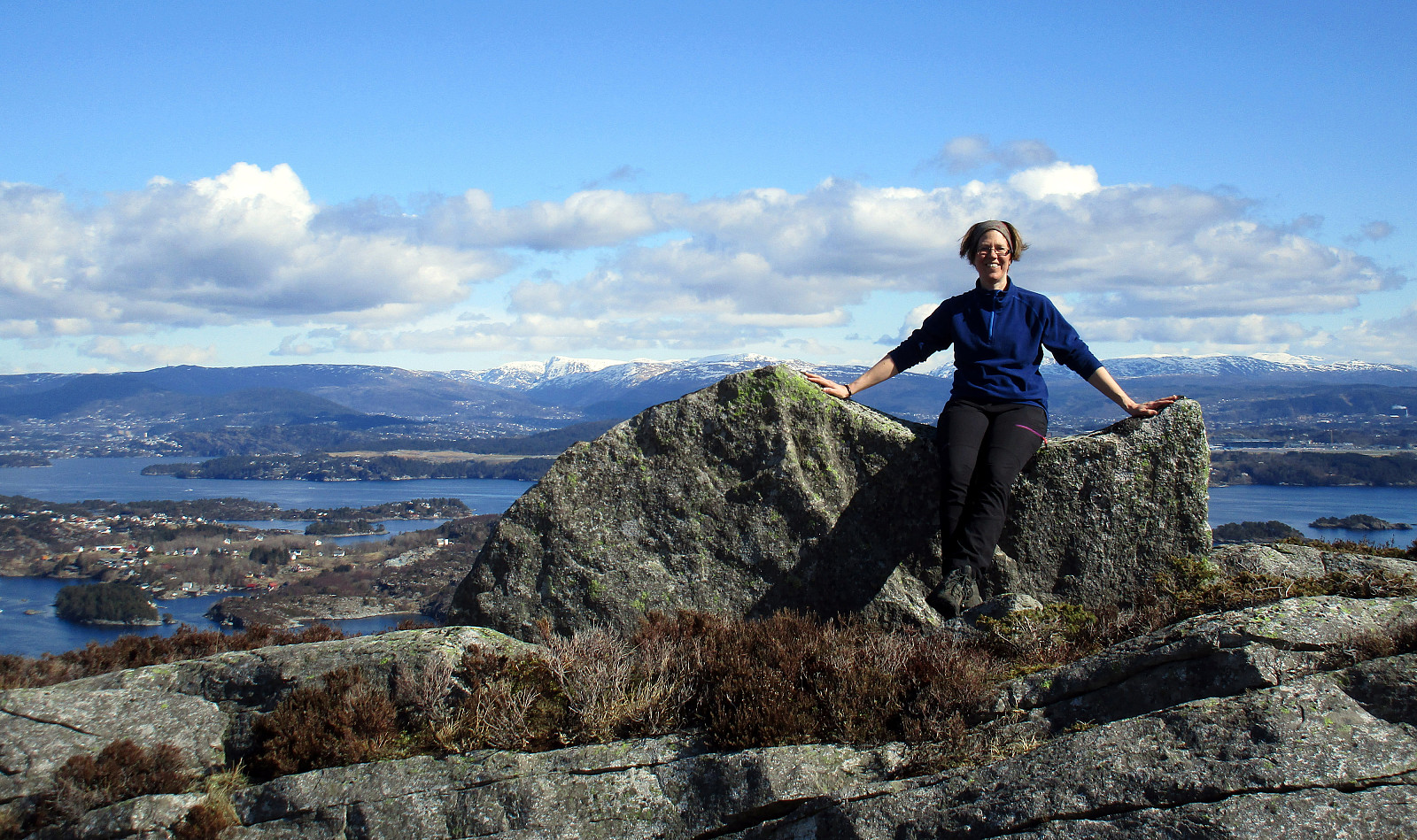
We drove from Bergen to Sotra, turning left before entering the tunnel and driving south to Liaskjæret on the eastside of the island. We parked near Liaskjervegen 182, i.e., very close to the point at the street, where the bus turns around. We followed the street southwards, basically to its end---very near to a small harbor for private boats. We went around the last houses and came soon to a small bay (called Nordra Skagavika). From there, we followed a very simple path that leads up to a small lake (Røssevikvatnet). We continued on the western side of this small lake, approaching Hansafjellet. It's straight-forward to hike there, even though we could not see any paths (occasionally, it's wet, yes). It was good to change over to Hansafjellet on its northern end---ascending to this little top directly from the East is a little steep. We then walked over Hansafjellet (from north to south) and enjoyed some nice views from there. Especially the southern "top" of Hansafjellet is nice---it looks a little like an eagle aery! :-) From there, we followed the south-facing ridge, descending from Hansafjellet---it's western side is very steep and quite a bit of climbing would be needed to get down (or up). Back down from Hansafjellet, we continued southwards towards Lundaneset. We went all the way south until a nice spot, where we enjoyed the view over the sea and a sip of water. From there, we continued in northwestern direction, ascending to a small cliff that is really very steep on its western side (right above a house that sits in the valley underneath somewhat lonely, without any street connection, at least). We then followed the ridge on top of this cliff northwards until there was an opportunity to turn left, towards West, again. There, we switched over to Kjerringestigen and ascended directly to Alteret (first the smaller, southern top, before then connecting to the highest point of Alteret). From there, we continued towards North, quickly getting to a place called Adneviksbakkane. There, we crossed over (in northeastern direction) in order to ascend to Indrafjellet. It's a slightly little bit tricky to find a good spot for ascended up there, but once identified, it's not really a big deal (a few climbing steps are needed). Indrafjellet is really worth visiting, after all, even though it isn't very high. Still, the views are terrific from up there---in all directions, basically! Also, you can find a place right at the top, where you can sit down conveniently to have a small break---nice! :-) We then continued northwards on Indrafjellet, descending along a small path that leads up to Indrafjellet from Haganes. To find the place, where this path turns around (towards Haganes), is not completely obvious and one may miss it, walking down from Indrafjellet to far on the East. The path leads down into a small valley and turns, then, into southwestern direction, leading via a small saddle into the small, half-high plateau right underneath Indrafjellet. Right on this small saddle, we took a turn to the right, left the path, and ascended to a small top right above Brattstigvatnet---what a great view from up there?!! :-) From there, we continued northwards along the high ridge (very steep cliff to the west of it!) and approached Kattafjellet next. There, one can overlook Kattatjørna right underneath and the view is really great since Kattafjellet is so steep on its western side. From there, we first descended from Kattafjellet to the saddle in the north of it, before we turn right, into eastern direction, descended further into Risdalen. There, we crossed the bottom of this small valley (one has to look out, where to actually get down, after all, because some sides of Risdalen are also quite steep) and got over to a small ridge (with a path!). We followed this path, then, towards Trollhaugen, where we turned right, in eastern direction, connecting to Elvabakkvegen from there (probably it's better to continued on the half-height near Trollhaugen and connect to the road a bit further northeast from there, though). Completing our round, we walked Elvabakkvegen down and ended up very close to our car. All in all, this was a beautiful hike in fantastic weather. Lundaneset is really worth visiting, even though one gets the impression that not many walk there, really. Lundaneset is much easier and straight-forward to reach from Lia/Liaskjæret---getting there from Haganes is not at all trivial and one has to make good plans (of where to go); the west-facing cliffs around there (several!) are serious obstacles (even though not very high!) and normal hiking (without significant climbing) requires some detours around the north-ends of these cliffs, for example, to really get to Lundaneset. Do Lundaneset from Haganes via Alteret and/or Indrafjellet, however, should be straight-forward.
Photos
Selected photos are available as Google photo album.
Useful Resources
See also the related FB-page Hiking around Bergen, Norway.
Web page UT.no from the Norwegian Trekking Association recommends another hike up and down Indrafjellet (from Haganes).


User comments