Archiv - Nach Datum
Peakbookfreunde


Lieblingstouren
Lieblingsgipfel


Kasberget
- Datum:
- 26.09.2021
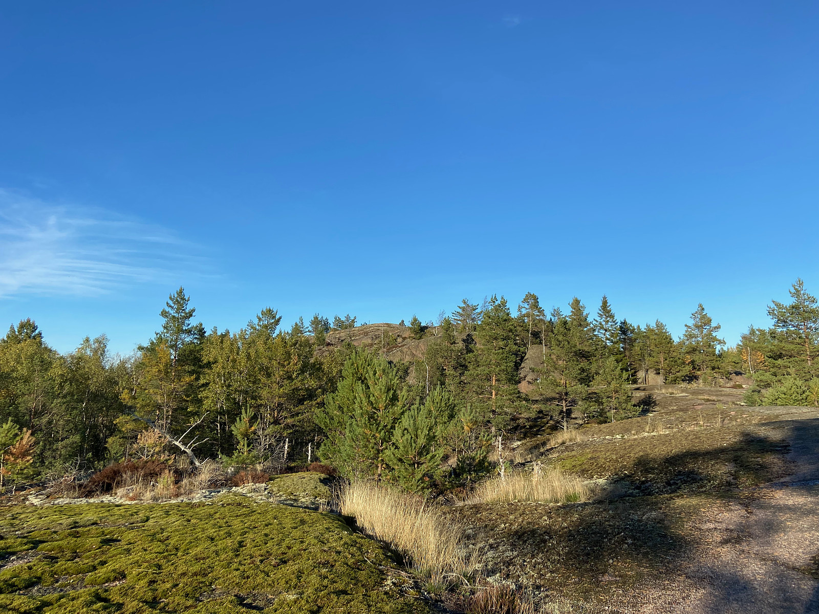 Trail running in Porkkala and found this gentle hill with beautiful views towards the sea.
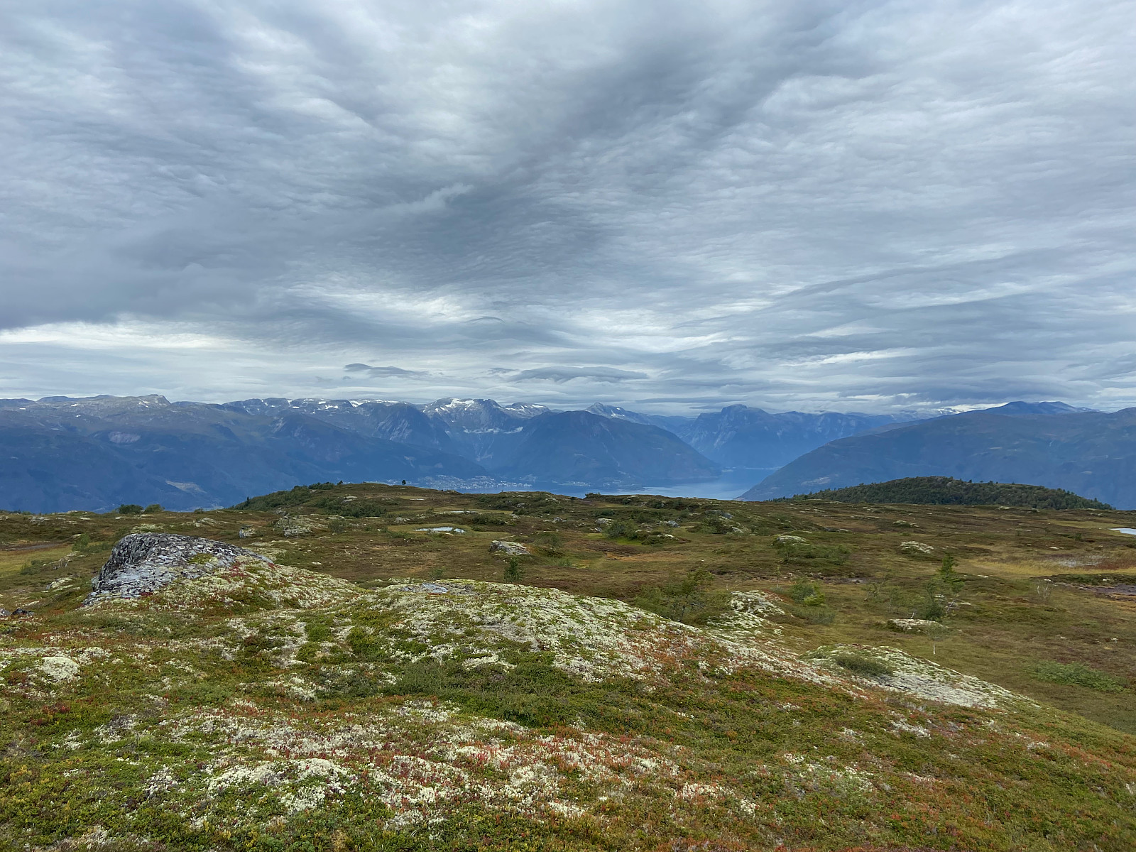
Kongshaug
- Datum:
- 24.08.2021
 Trip article in english & finnish
Last day in Norway so we decided to look for fjord views one more time. We checked ut.no and found Konshaug-hike from Vikøyri, it looked nice and easy.
Varpet parking lot was easy to find with navigator & signs along the road. Easy trail to follow with decent signs towards Kallbak. First kilometer on a dirt road, then 1-2km under the powerline and in birch wood. The trail under / around powerline reminded me too much of the urban trails around Helsinki, a bit dissappointing. Really easy and gentle ascent. After passing Nyastøl it began to look more like Norway and mountains - fortunately. We arrived at Kallbak and I decided to run to Flatafjellet summit while others turned towards Kongshaug. I suppose there was a proper trail also to Flatafjellet but >>>
Trip article in english & finnish
Last day in Norway so we decided to look for fjord views one more time. We checked ut.no and found Konshaug-hike from Vikøyri, it looked nice and easy.
Varpet parking lot was easy to find with navigator & signs along the road. Easy trail to follow with decent signs towards Kallbak. First kilometer on a dirt road, then 1-2km under the powerline and in birch wood. The trail under / around powerline reminded me too much of the urban trails around Helsinki, a bit dissappointing. Really easy and gentle ascent. After passing Nyastøl it began to look more like Norway and mountains - fortunately. We arrived at Kallbak and I decided to run to Flatafjellet summit while others turned towards Kongshaug. I suppose there was a proper trail also to Flatafjellet but >>>
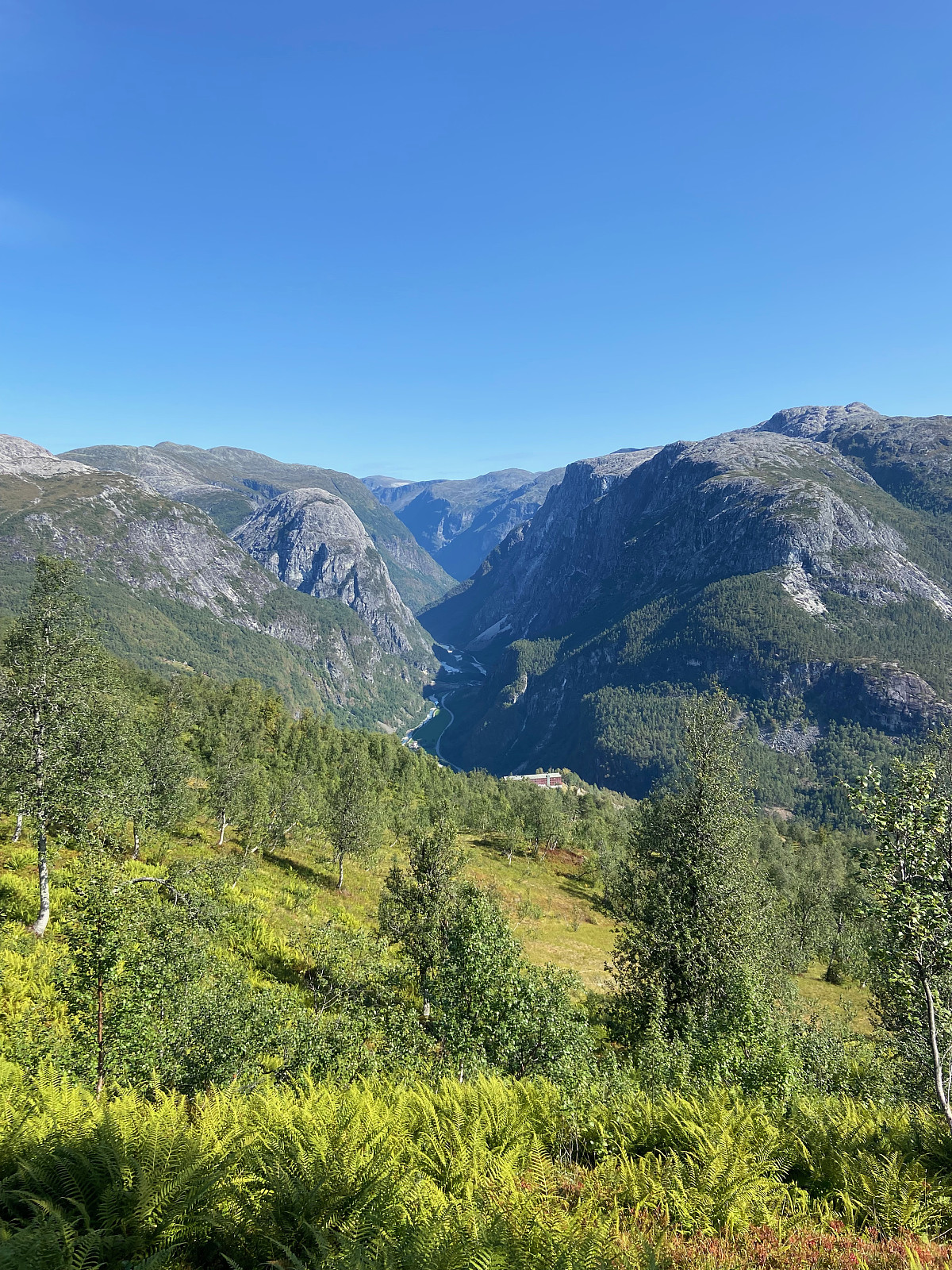
Brekkenipa
- Datum:
- 23.08.2021
 Trip article in finnish and shortly in english.
Our cabins "landlord" suggested that we should hike to Brekkenipa just above our accommodaton. The trail started from our yard so that was a easy plan. We were told that the first part was labeled as "black" but there would not be any kind of problems with proper shoes. Beginning was truly a bit challenging with all the steepness, narrow path and vegetation. At first the route was clearly marked and path easy to follow. Immediately when we got away from the steep part and bushes, the path dissappeared and we couldn't find any marks either. Fortunately that was no problem cause the summit ridge was clearly visible so we just planned our own route to the top-plateau. We hiked all the 3-4 summits of Brekkenipa and on the northernmost >>>
Trip article in finnish and shortly in english.
Our cabins "landlord" suggested that we should hike to Brekkenipa just above our accommodaton. The trail started from our yard so that was a easy plan. We were told that the first part was labeled as "black" but there would not be any kind of problems with proper shoes. Beginning was truly a bit challenging with all the steepness, narrow path and vegetation. At first the route was clearly marked and path easy to follow. Immediately when we got away from the steep part and bushes, the path dissappeared and we couldn't find any marks either. Fortunately that was no problem cause the summit ridge was clearly visible so we just planned our own route to the top-plateau. We hiked all the 3-4 summits of Brekkenipa and on the northernmost >>>
Evening run
- Datum:
- 23.08.2021
- Tourlänge:
- 1:07h
- Entfernung:
- 9,6km
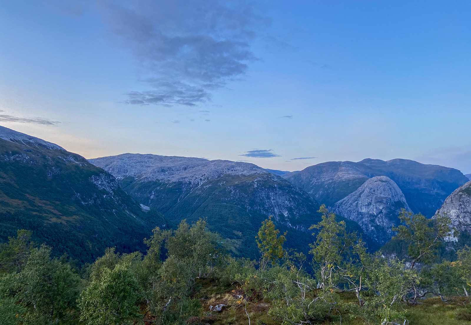 After our adventurous day-hike to Brekkenipa I still wanted one more "summit" for the evening while the others of our group decided to drive to Stegastein for sunset. I checked the local guide and found easy route to Slænshovden just next to our cabin. I decided to run as much as I could. First easy running on road & dirt road and then on a good trail with good signs. Then again around 500m elevation the trail and signs dissappeared for a while and I just pushed up my own routes. Good views from the top, nice sunset. On the top I looked map and noticed that with only 100m descent off-trail I would meet a dirt road that would lead me back to Stalheim, so I could get a round trip. First part of descending was easy. Then I found a good path, which I managed to lose pretty fast. >>>
Bakkanosi
- Datum:
- 22.08.2021
 Trip article in finnish and shortly in english.
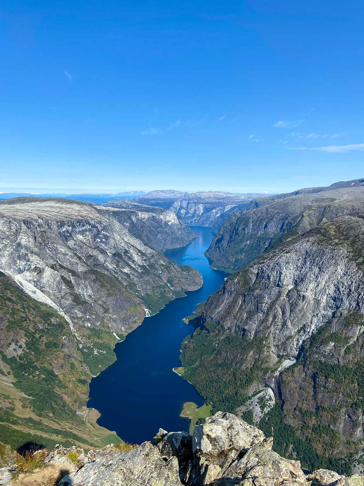
Bakkanosi is marked as "red" or "black" hike according to ut.no or local hiking-guides. The route is not too steep or anyway technical, it is just long-ish and not clearly marked. Anyway on a clear day it is very easy to follow the path and/or find your own route, but with foggy weather I believe it could turn a bit tricky (you propably don't want to get lost 9km away from nearest road with steep mountain faces all around you).
The views are world-class. Don't know if I was more amazed with the fjord-view 1400m below me or with the view towards Hurrungane almost 100km away.
Taas yksi haikkaus, jota olen kuolannut jo vuosia. Nærøyfjordenin alue on jäänyt toistaiseksi tuntemattomammaksi, joten oli kiva viettää reissun loppuun >>>
Trip article in finnish and shortly in english.
Bakkanosi is marked as "red" or "black" hike according to ut.no or local hiking-guides. The route is not too steep or anyway technical, it is just long-ish and not clearly marked. Anyway on a clear day it is very easy to follow the path and/or find your own route, but with foggy weather I believe it could turn a bit tricky (you propably don't want to get lost 9km away from nearest road with steep mountain faces all around you).
The views are world-class. Don't know if I was more amazed with the fjord-view 1400m below me or with the view towards Hurrungane almost 100km away.
Taas yksi haikkaus, jota olen kuolannut jo vuosia. Nærøyfjordenin alue on jäänyt toistaiseksi tuntemattomammaksi, joten oli kiva viettää reissun loppuun >>>
Lett fjelltur fra Krossbu
- Datum:
- 21.08.2021
- Tourcharakter:
- Jogging
- Tourlänge:
- 2:22h
- Entfernung:
- 8,0km
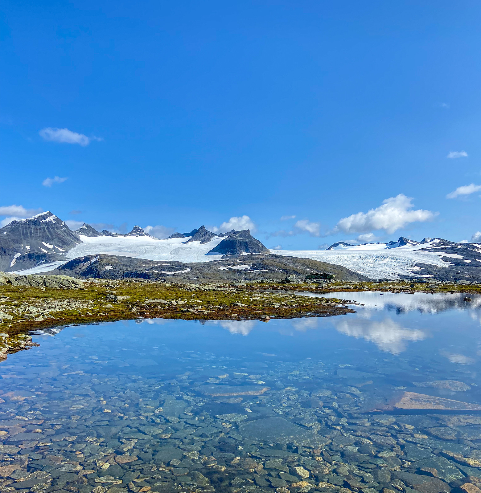 Easy hiking / running around Krosshøe. Amazing views towards Smørstabbtindene, Fannaråki & Styggedalstindane.
We did this hike when driving from Geiranger to Aurland, pretty ideal spot for a short-ish hike when just stopping by. We started following path from Krossbu towards Nørdstedalseter (west / nw). After aprx 4km the path runs just by the summit of Krosshøe. We left the path and started to go off-trail, easy terraing. Good area for off-trail or trail-running, not too steep ascents, amazing views all around.
Ajopäivän keskelle parin tunnin todella kiva ja suhteellisen helppo haikkaus / juoksentelu Sognefjelletillä. Auto parkkiin Krossbun vuorimajalle, jonka takaa kohti Nørdstedalseteriä (länsi, luode) lähtee DNT:n merkitty reitti. Alkuun hieman tehokkaampi nousu, jonka jälkeen >>>
Easy hiking / running around Krosshøe. Amazing views towards Smørstabbtindene, Fannaråki & Styggedalstindane.
We did this hike when driving from Geiranger to Aurland, pretty ideal spot for a short-ish hike when just stopping by. We started following path from Krossbu towards Nørdstedalseter (west / nw). After aprx 4km the path runs just by the summit of Krosshøe. We left the path and started to go off-trail, easy terraing. Good area for off-trail or trail-running, not too steep ascents, amazing views all around.
Ajopäivän keskelle parin tunnin todella kiva ja suhteellisen helppo haikkaus / juoksentelu Sognefjelletillä. Auto parkkiin Krossbun vuorimajalle, jonka takaa kohti Nørdstedalseteriä (länsi, luode) lähtee DNT:n merkitty reitti. Alkuun hieman tehokkaampi nousu, jonka jälkeen >>>

