
Holdhusfjellet from Raunekleiva (24.04.2021)

Skrevet av HHauser (Helwig Hauser)

| Startsted | Raunekleiva (110moh) |
|---|---|
| Sluttsted | Raunekleiva (110moh) |
| Turtype | Fottur |
| Turlengde | 5t 00min |
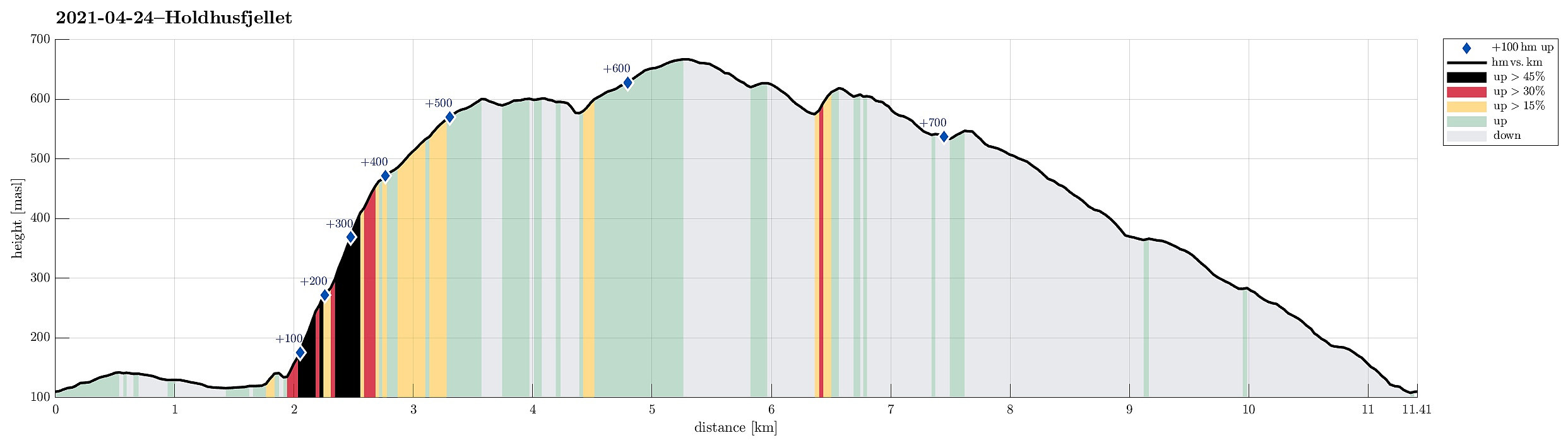
| Distanse | 11,4km |
| Høydemeter | 722m |
| GPS |
|
| Bestigninger | Holdhusfjellet (607moh) | 24.04.2021 |
|---|---|---|
| Raudfjell (671moh) | 24.04.2021 | |
| Andre besøkte PBE'er | Raunekleiva parkering (110moh) | 24.04.2021 |
Trip Summary
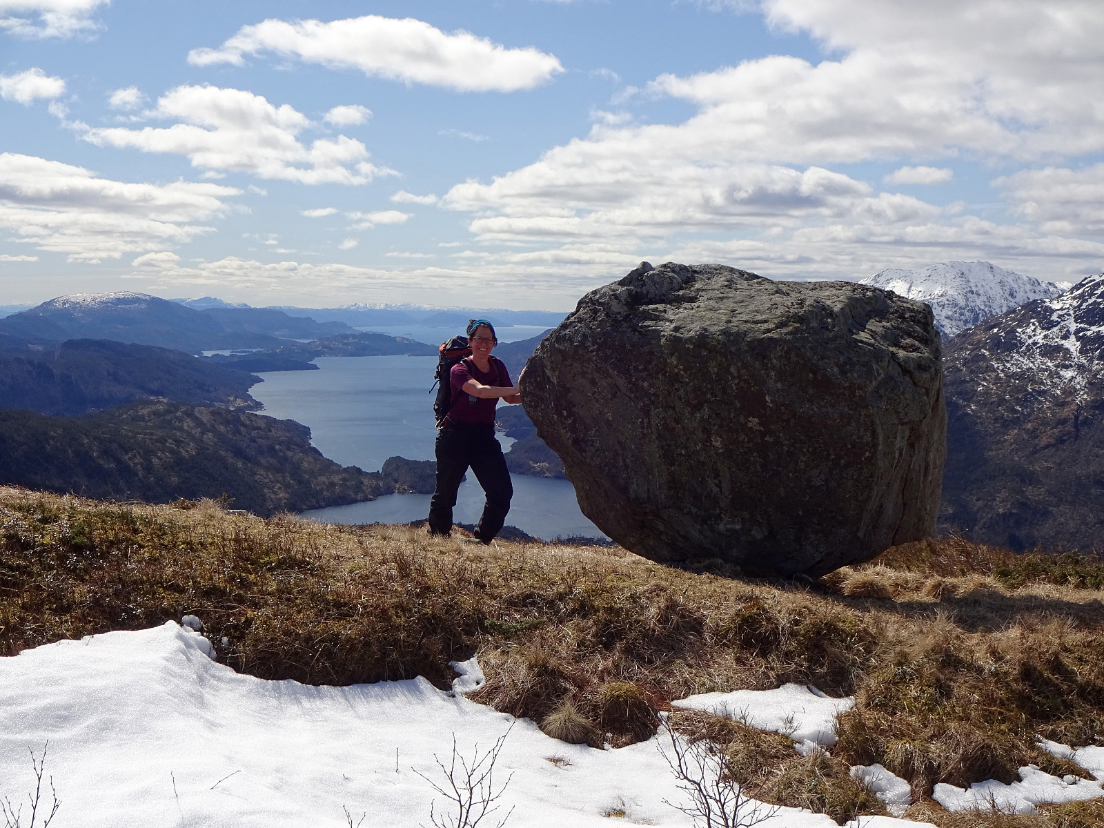
The plan was to hike Holdhusfjellet from the south. To do so, we took the car into the east of Bergen, driving along E16 first. At Trengereid, we changed to road #7, driving towards Samnanger (via Gullbotn). After passing by Gullbotn, but before getting all the way down to Samnanger (just east of Hisdalen), we parked right next to the recycling area at Raunekleiva (we expected to come down there, following the prominent trail that leads to Raudvatnet from there). From there, we first walked along the old road back along Samnangervegen in westward direction. Walking by Leitet and Hisdalen, we approached the steep southeastern slopes of Holdhusfjellet. Ahead of time, we had discussed about how to actually ascend to Holdhusfjellet. One idea was to ascend to Akselskaret, first, and from there further upwards to Holdhusfjellet. The other idea was to make an attempt across the entire southern ridge of Holdhusfjellet, starting a bit further in the west (the map suggested a non-trivial start into this ascent, especially in the lower parts that extend over Hisdalstunnelen). As we walked by Holdhus (along Samnangervegen), we talked to a person and he suggested that we follow a trail up to Akselskaret. Showing us the trail head, we took this as a decision and continued, accordingly. To our surprise, we found this trail very well marked and straight-forward to follow (the trail leads upwards very steeply, but throughout its course one does not face any real difficulties). Once we came up to Akselskaret, we found it to be an amazing pace with an excellent view over Hisdalen. After enjoying this place for a moment, we continued further upwards, reaching a small cabin, called Nipen, shortly after. This cabin really is built on an amazing place with beautiful views across Samnanger. After staying at this cabin for a few minutes, we continued further upwards into the direction of Holdhusfjellet. A couple of minutes later, we had left the forest behind us and we continued across the by then less steep southwestern slope of Holdhusfjellet. One unexpected surprise there was to come by a relatively big rock that appears to have been dropped there somehow. From there, it wasn't much longer to actually get up to Holdhusfjellet, which isn't really much of a top, but definitely a place with great views, for ex., out Samnangerfjorden, towards Gullfjellet, as well as into the direction of Tysse. From Holdhusfjellet, we continued towards the next goal, Raudfjellet. At first, we needed to get off the "cliff" (towards the east) that runs south from Krånipa to Holdhusfjellet. With still a significant amount of snow up there, we walked along this cliff for a bit before stepping down at a place, where it looked reasonably well possible (which it was). Once across Dalaelva right below the "cliff", we started the ascent to Raudfjellet (in northeastern direction). Even though the isn't really any trail there, the terrain is non-difficult to traverse and so we arrived at Raudfjellt soon after. From Raudfjellet, we continued into the direction of Raudvatnet. Even though there are not really any high tops in the south of Holmavatnet, one should be aware that the terrain come with some steep parts. After a bit of down and up, we found ourselves on the top of a steep, east-facing cliff. To actually get down and connect to the main trail between Raunekleiva in the south and Raudvatnet, we decided to talk out the cliff in northern direction. This brought us very close to Raudvatnet, before we made it down and connected to the trail. Once in the south of Raudvatnet and on the trail, we just walked this trail down to Raunekleiva. This trail is really well marked and easy to find and follow. All in all, this round was really rewarding. Especially the trail up to Akselskaret (and from there to Holdhusfjellet) was a very positive surprise. Once on Holdhusfjellet, one also has a number of alternative options, including Krånipa, Raudnipa, and more.
Photos
Selected photos are available as Google photo album.
Useful Resources
See also the related FB-page Hiking around Bergen, Norway.
Petter Bjørstad has a useful page about Hananipa (which also links to pages about Raudnipa and Krånipa) and also web page WestCoastPeaks.com provides useful information about Hananipa, Raudnipa, Krånipa, and Raudfjell.
Web page UT.no from the Norwegian Trekking Association recommends to hike up from Raunekleiva to Raudnipa.


Kommentarer