Arkiv - dato
Arkiv - aktivitet
-
Annen tur (1)
- Ekspedisjon (1)
-
Annen vintertur (10)
- Trugetur (10)
- Fottur (228)
-
Klatring (8)
- Alpin klatring (7)
- Miksklatring (1)
-
Skitur (49)
- Randonnée/Telemark (49)
-
Sykkeltur (2)
- Terrengsykling (1)


Lister jeg samler etter
-
Romsdal ≥ 100m pf.
(134/301)
 44%
44% -
Sunnmøre ≥ 100m pf.
(78/531)
14%
-
Norges 1000 største fjell målt i primærfaktor
(52/1000)
5%

Hildrehesten på langs
- Dato:
- 27.08.2016
- Turtype:
- Fjelltur
- Turlengde:
- 5:24t
- Distanse:
- 14,9km
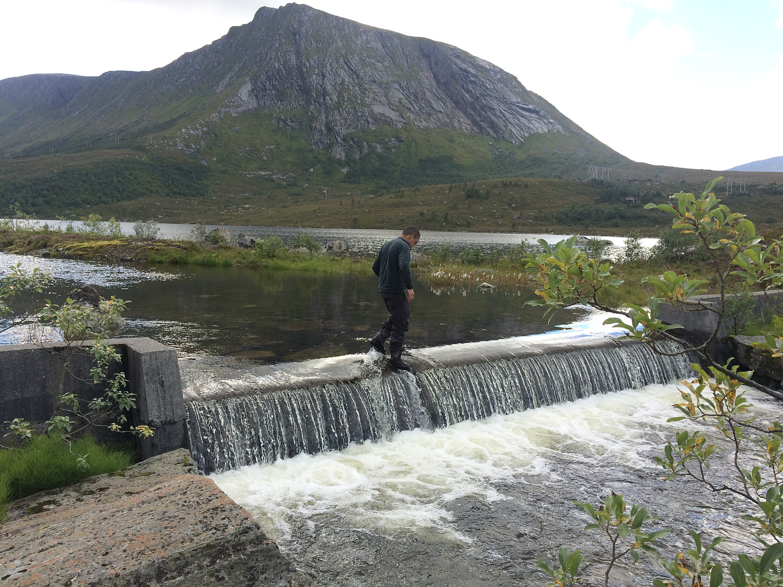 Eldste sønnen går mye på fjelltur, og denne lørdagen lurte han på om ikke jeg ville bli med en tur på Hildrehesten. Vi kjørte til Brattvåg sentrum, svingte opp mot Synnalandsvatnet, og parkerte bilen på parkeringsplassen rett ved demningen. Så krysset vi over på demningen, og la avgårde oppover fjellsida. Stien opp mot Store Hestevatnet og Hildrehesten var godt merka, og turen opp gjennom skogen gikk radig.
Oppe ved Store Hestevatnet tok vi oss tid til å fotografere litt, før vi gikk videre. Der elva fra vatnet renner over i Hestetjønnene, var det en liten demning, hvor vatnet fosset over med en dybde på ca. 25 cm. Min sønn hadde høye fjellstøvler, og vasset greit over. Mine var lavere, så jeg tok av meg på føttene, og vasset barføtt over. Stien videre gikk i en slakk >>>
Eldste sønnen går mye på fjelltur, og denne lørdagen lurte han på om ikke jeg ville bli med en tur på Hildrehesten. Vi kjørte til Brattvåg sentrum, svingte opp mot Synnalandsvatnet, og parkerte bilen på parkeringsplassen rett ved demningen. Så krysset vi over på demningen, og la avgårde oppover fjellsida. Stien opp mot Store Hestevatnet og Hildrehesten var godt merka, og turen opp gjennom skogen gikk radig.
Oppe ved Store Hestevatnet tok vi oss tid til å fotografere litt, før vi gikk videre. Der elva fra vatnet renner over i Hestetjønnene, var det en liten demning, hvor vatnet fosset over med en dybde på ca. 25 cm. Min sønn hadde høye fjellstøvler, og vasset greit over. Mine var lavere, så jeg tok av meg på føttene, og vasset barføtt over. Stien videre gikk i en slakk >>>
Fjelltur i ørkenen
- Dato:
- 13.08.2016
- Turtype:
- Fjelltur
- Turlengde:
- 1:51t
- Distanse:
- 6,1km
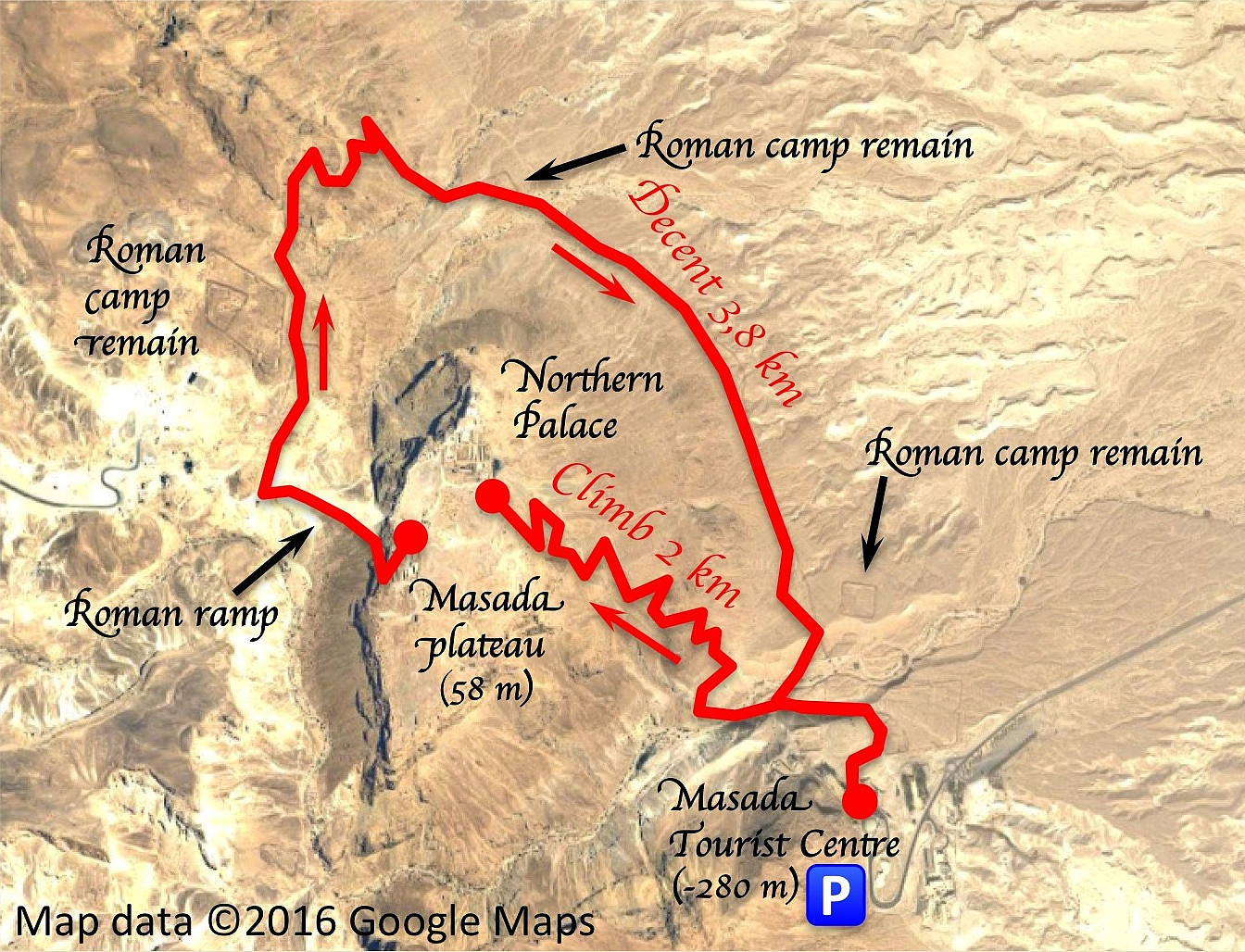 Masada er en kalksteinsklippe i Judea-ørkenen i Israel, rett vest for Dødehavet. Klippen har et nokså flatt platå på toppen, og her oppe bygde kong Herodes den store (ca. 73 - ca. 4 f.Kr) et palass hvor han kunne bo om vinteren, når han syntes det var for kaldt i Jerusalem, som ligger ca. 750 m.o.h. Ruinene av dette palasset er i seg selv verd et besøk, også om man må benytte kabelvognen for å komme seg opp. Jeg hadde imidlertid vært der en gang før, og det som tiltrakk meg ved denne anledningen var tanken på å gå stien opp fra dødehavssletta opp til toppen av Masada.
Det som er utfordrende med turen opp på Masada er ikke høyden, men den intense heten. Masada-platået ligger bare ca. 30 m.o.h., mens turistsenteret, hvor man finner slike ting som parkering, suvenirbutikk og >>>
Masada er en kalksteinsklippe i Judea-ørkenen i Israel, rett vest for Dødehavet. Klippen har et nokså flatt platå på toppen, og her oppe bygde kong Herodes den store (ca. 73 - ca. 4 f.Kr) et palass hvor han kunne bo om vinteren, når han syntes det var for kaldt i Jerusalem, som ligger ca. 750 m.o.h. Ruinene av dette palasset er i seg selv verd et besøk, også om man må benytte kabelvognen for å komme seg opp. Jeg hadde imidlertid vært der en gang før, og det som tiltrakk meg ved denne anledningen var tanken på å gå stien opp fra dødehavssletta opp til toppen av Masada.
Det som er utfordrende med turen opp på Masada er ikke høyden, men den intense heten. Masada-platået ligger bare ca. 30 m.o.h., mens turistsenteret, hvor man finner slike ting som parkering, suvenirbutikk og >>>
Til Ytsetind fra Flate
- Dato:
- 11.06.2016
- Turtype:
- Fjelltur
- Turlengde:
- 3:55t
- Distanse:
- 12,5km
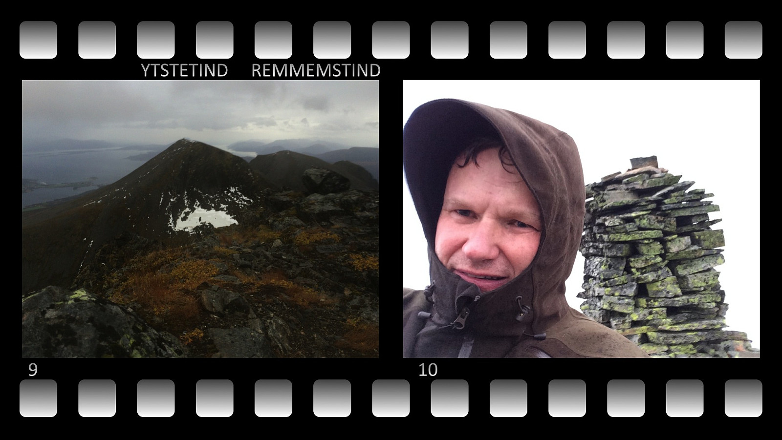
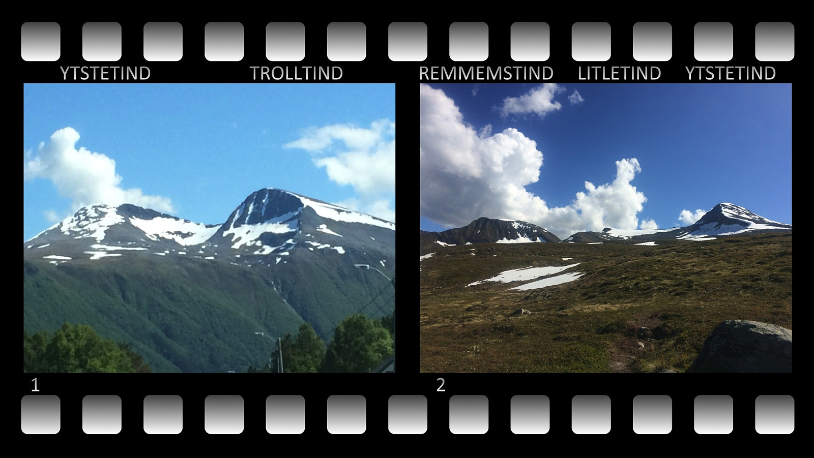 I 2015 besøkte jeg både Remmemstinden og Trolltinden i Vestnes kommune, men Ytstetinden hadde jeg enda ikke vært på, og dit hadde jeg lyst å gå. Denne lørdagen dro vi derfor avsted, jeg og eldste sønnen vår. Vi kjørte via Fiksdal og Tomrefjorden til Flatebygda, og fant fram til en parkeringsplass vi også tidligere hadde benyttet. Det var 20,- kroner å betale i bompenger for å komme opp til parkeringsplassen, og derfra la vi i vei oppover grusveien til Flateseter. Oppe ved Flatesetra er stien videre til Remmemstinden og Ytstetinden godt skiltet; dårligere med skilting er det når man kommer ut av skogen og opp på snaufjellet.
Ytstetind er forbundet med fjellet Båten med en rygg som kalles Båtreset . Vi siktet oss inn på foten av Ytstetind akkurat der fjellet går over i Båtreset. >>>
I 2015 besøkte jeg både Remmemstinden og Trolltinden i Vestnes kommune, men Ytstetinden hadde jeg enda ikke vært på, og dit hadde jeg lyst å gå. Denne lørdagen dro vi derfor avsted, jeg og eldste sønnen vår. Vi kjørte via Fiksdal og Tomrefjorden til Flatebygda, og fant fram til en parkeringsplass vi også tidligere hadde benyttet. Det var 20,- kroner å betale i bompenger for å komme opp til parkeringsplassen, og derfra la vi i vei oppover grusveien til Flateseter. Oppe ved Flatesetra er stien videre til Remmemstinden og Ytstetinden godt skiltet; dårligere med skilting er det når man kommer ut av skogen og opp på snaufjellet.
Ytstetind er forbundet med fjellet Båten med en rygg som kalles Båtreset . Vi siktet oss inn på foten av Ytstetind akkurat der fjellet går over i Båtreset. >>>
Til Båten og Trolltind fra Flate
- Dato:
- 31.10.2015
- Turtype:
- Fjelltur
- Turlengde:
- 5:46t
- Distanse:
- 16,2km
 Etter å ha besteget Remmemstind et par ganger denne høsten, hadde jeg fått lyst til å prøve meg på Trolltind og Ytstetind. [Navnet på førstnevnte varierer mellom ulike kart og alt etter hvem du spør, noen kaller den Brustind, mens andre kaller den Trolltind]. Jeg kjørte hjemmefra til Flatebygda innerst i Flatevågen, og tråklet meg frem mellom gardene på jakt etter en setervei jeg hadde sett på kartet. Det viste seg lettere å finne fram enn jeg hadde regnet med: Et skilt på en stolpe viste veg. Jeg fulgte denne skiltanvisningen over et gårdstun og rundt en bygning. Bak denne var en bom hvor man måtte betale 20,- kr. for å slippe forbi, og 100 meter forbi denne kom jeg til en stor åpen parkeringsplass; jeg går ut fra at bompengene er for å finansiere eller nedbetale denne. >>>
Hiking up Mount Ulriken in Bergen, Norway, with my son.
- Dato:
- 02.08.2015
- Turtype:
- Fjelltur
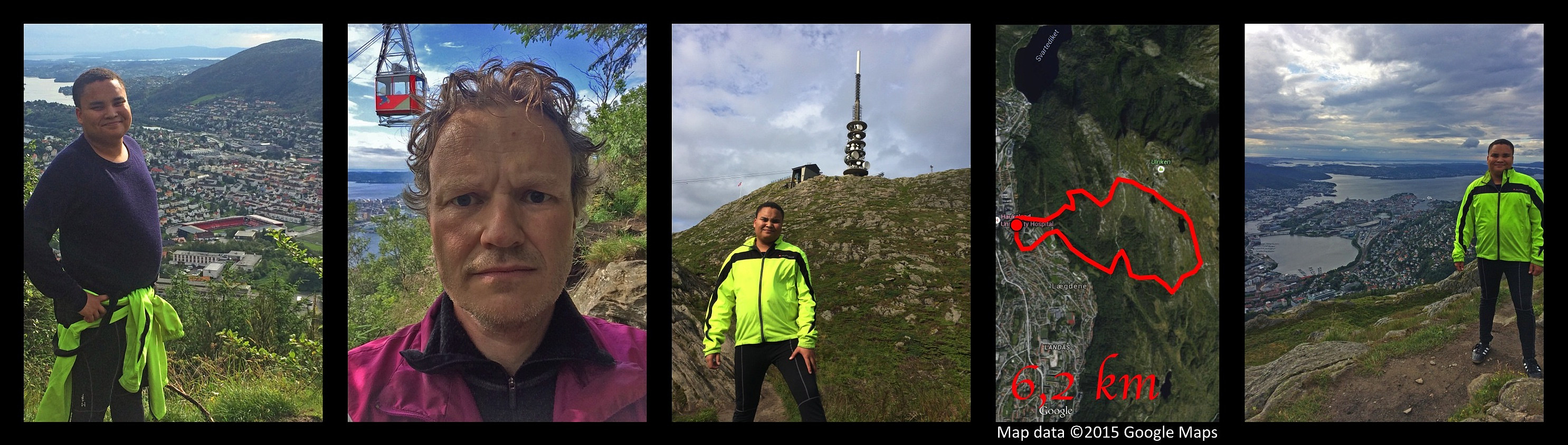 I went hiking on mount Ulriken in Bergen with my son Bror this afternoon. We had a really enjoyable trip, and weather was fairly nice most of the time, though we also had a shower of rain as we were heading back towards our new Bergen apartment. We climbed the mountain using a track just beneath the cable car that ascends the mountain. The lower part of the track goes through forest, and the upper part goes on bare mountain, with heather and moss as the only vegetation. We hiked up to the viewpoint where even the cable car takes the tourists. This isn't actually the highest point of this mountain massif, nor is it even the highest point of the part of the mountain that is known as Mount Ulriken, but it is the best viewpoint for an overview of the city, and it is the point that looks like it >>>
A Different Climb on the Godøy Island and Mount Storehornet
- Dato:
- 25.07.2015
- Turtype:
- Fjelltur
- Turlengde:
- 6:00t
- Distanse:
- 17,8km
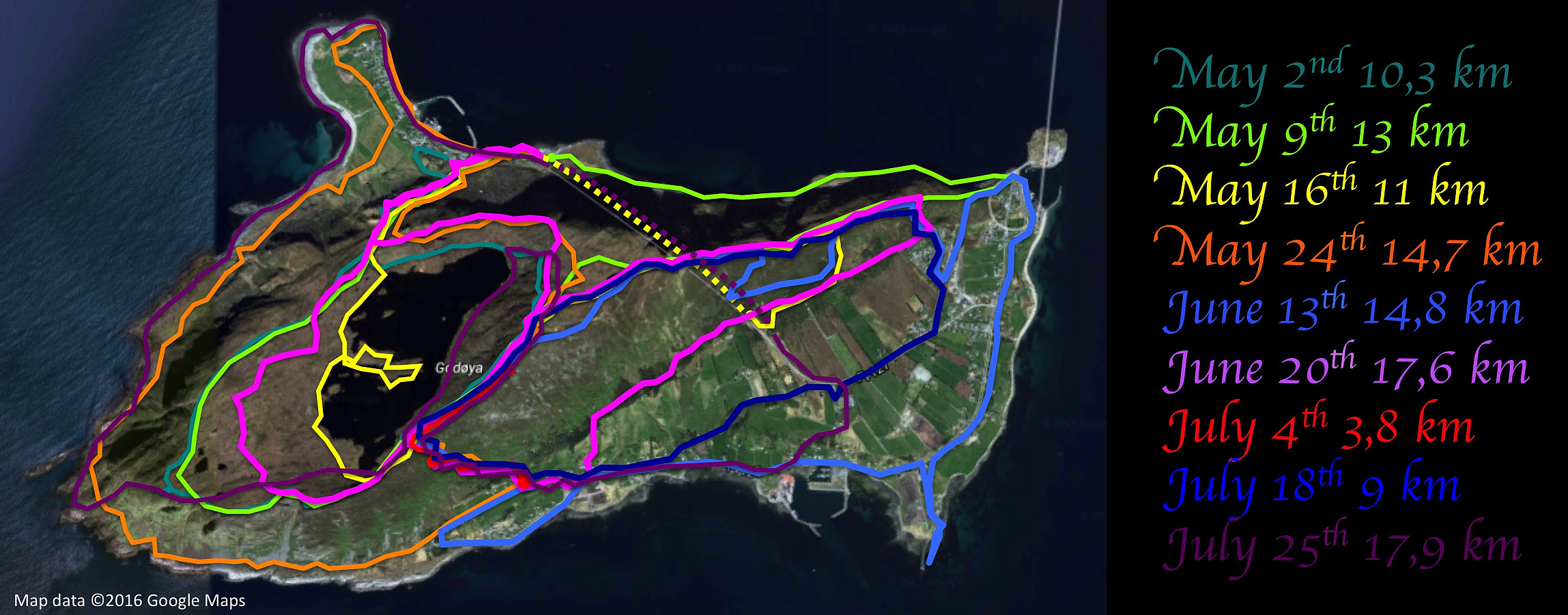 I went exploring the more inaccessible parts of the island Godøy this day. I've been waiting with this particular trip till I was all on my own, in order not to endanger the lives of my kids or my cousins, or anyone else that would like to join me on hiking. I parked my old car close to Alnes Lighthouse, then walked the shore towards the west-most point of the island. From there I climbed up the mountainside to Lestahalsen or Rantane, and then descended to the lake Alnesvatnet. I next walked (and some places climbed) along the eastern shore of the lake, then, from the north end of the lake started climbing towards the top of Storehornet, the highest peak of the island, with its 495 meters above mean sea level. From Storehornet I descended to Djuv, and from Djuv I finally returned to Alnes >>>
Crossing Mount Storhornet on Godøy Island from east to west
- Dato:
- 18.07.2015
- Turtype:
- Fjelltur
- Turlengde:
- 3:40t
- Distanse:
- 8,9km
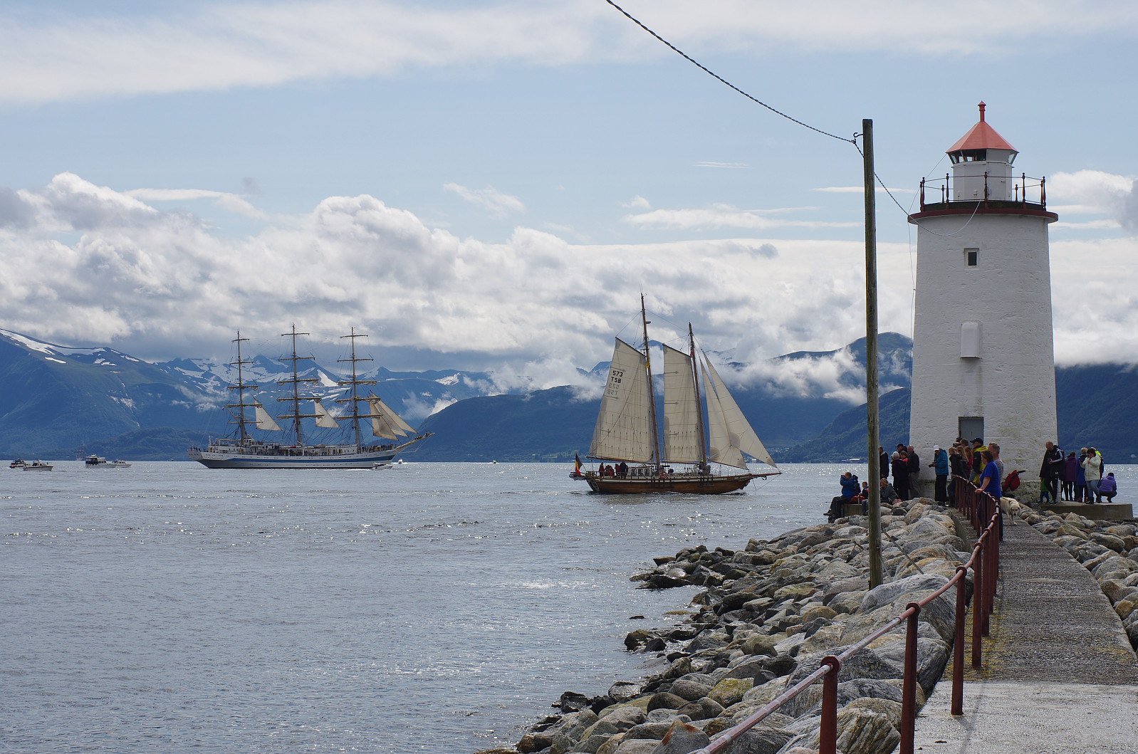 On this day I had a very nice hike on Godøy Island with my cousin Alexander from America. The Tall Ships Races had been in Ålesund for the last few days, and there was going to be a ship parade as all the ships were destined to leave Ålesund for their next harbor on this particular day. We had planned to climb the mountain of Godøy island in order to get a really good view of the Tall Ships Parade from the very summit of the mountain as the ships were departing. As we were driving towards the island, however, we noticed that much of the mountain on the island was concealed by low clouds, however, and so we decided to watch the tall ships from the breakwater of the Hogstein Lighthouse instead. It was an amazing experience to watch all these ships (Images 1 and 2). This event took some hours, >>>
From Djuv to Storehornet on Godøy Island
- Dato:
- 04.07.2015
- Turtype:
- Fjelltur
- Turlengde:
- 1:49t
- Distanse:
- 3,3km
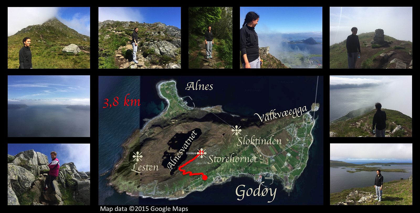 On this day I had a very nice trip to the summit of Storhornet on Godøy Island along with my older daughter. We went by car to a nice parking spot that has been made for mountain trekkers at Gjuv, and started our trek from there. The path up to about 270 m.a.m.s.l. is quite nice though a little bit wet in the upper part. Following this path you reach a mountain pass between Mount Storhornet on one side and Mount Lesten on the other side. From there the rather nice path goes down to the lake Alnesvatnet. Just there in the pass, however, you just take a track up to the right [i.e. eastwards], and this track will then lead you up to the summit of Storhornet. On this particular day, we noticed as we embarked on this last, rather steep climb, that the summit of the mountain was shrouded in clouds. >>>
Summiting Storhornet on Godøy Island twice in a day.
- Dato:
- 20.06.2015
- Turtype:
- Fjelltur
- Turlengde:
- 5:48t
- Distanse:
- 17,6km
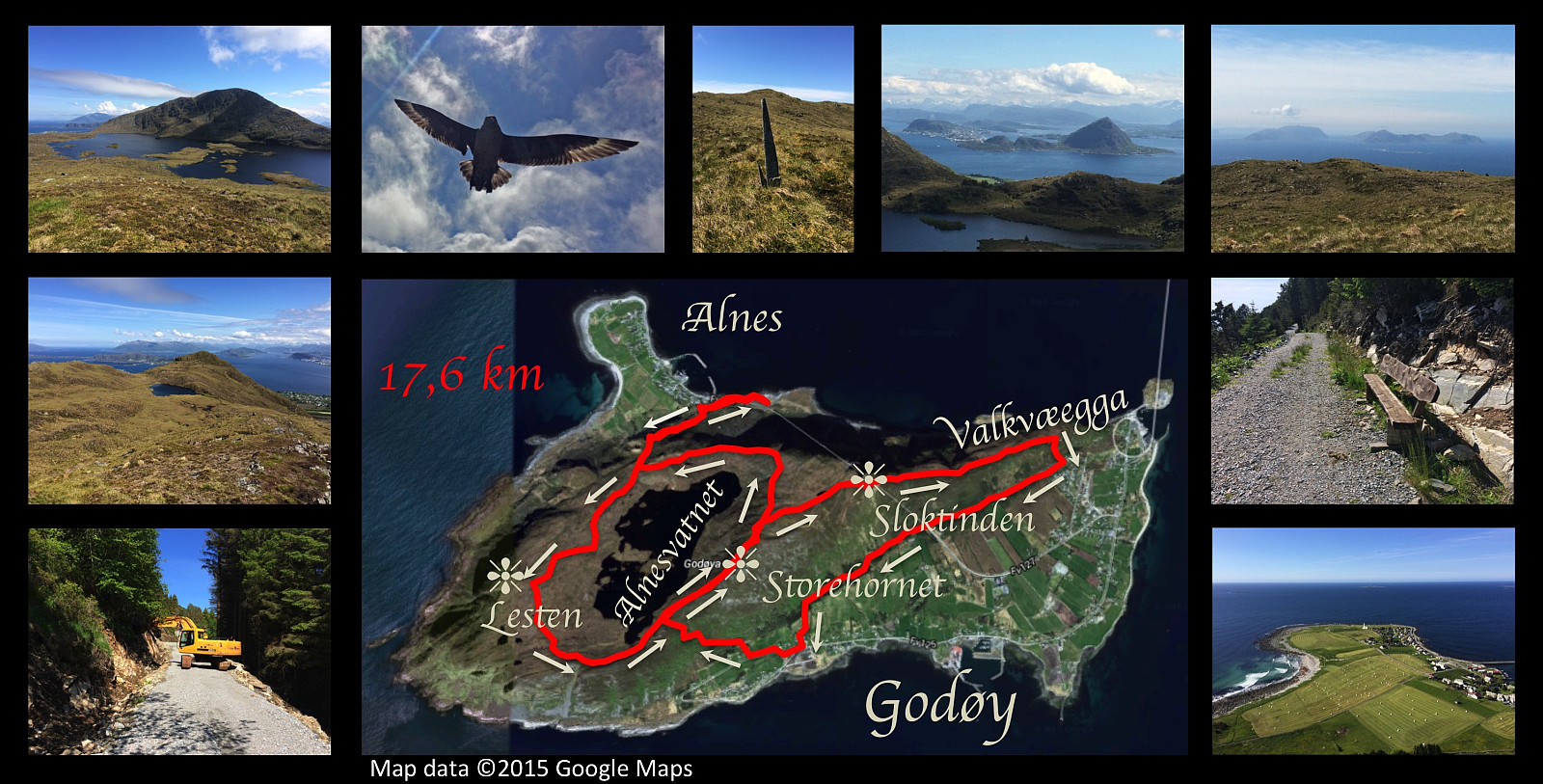 I had another nice hiking trip on the mountain of Godøy island this day. I started out from Alnes, and climbed up to the lake Alnesvatnet; then circumscribed the lake taking a track that I haven't used earlier. I had previously walked along the shore of the lake, and also over the mountain called Lesten, but this time I chose an in-between path about midway between the lake and the summit of Lesten, before ascending the final climb to the peak Storehornet, 497 meters above sea level. From Storehornet I went down the mountain ridge Valkvæegga to Valkvæ, and then westwards to Djuv on the south side of the mountain along a road under construction called Fjellfotveien (i.e. The Mountain Foot Road ). From Djuv I then climbed up to Storehornet a second time on this day, before finding my way down >>>
Round-trip on eastern part of the mountain of Godøy Island
- Dato:
- 13.06.2015
- Turtype:
- Fjelltur
- Turlengde:
- 4:43t
- Distanse:
- 14,8km
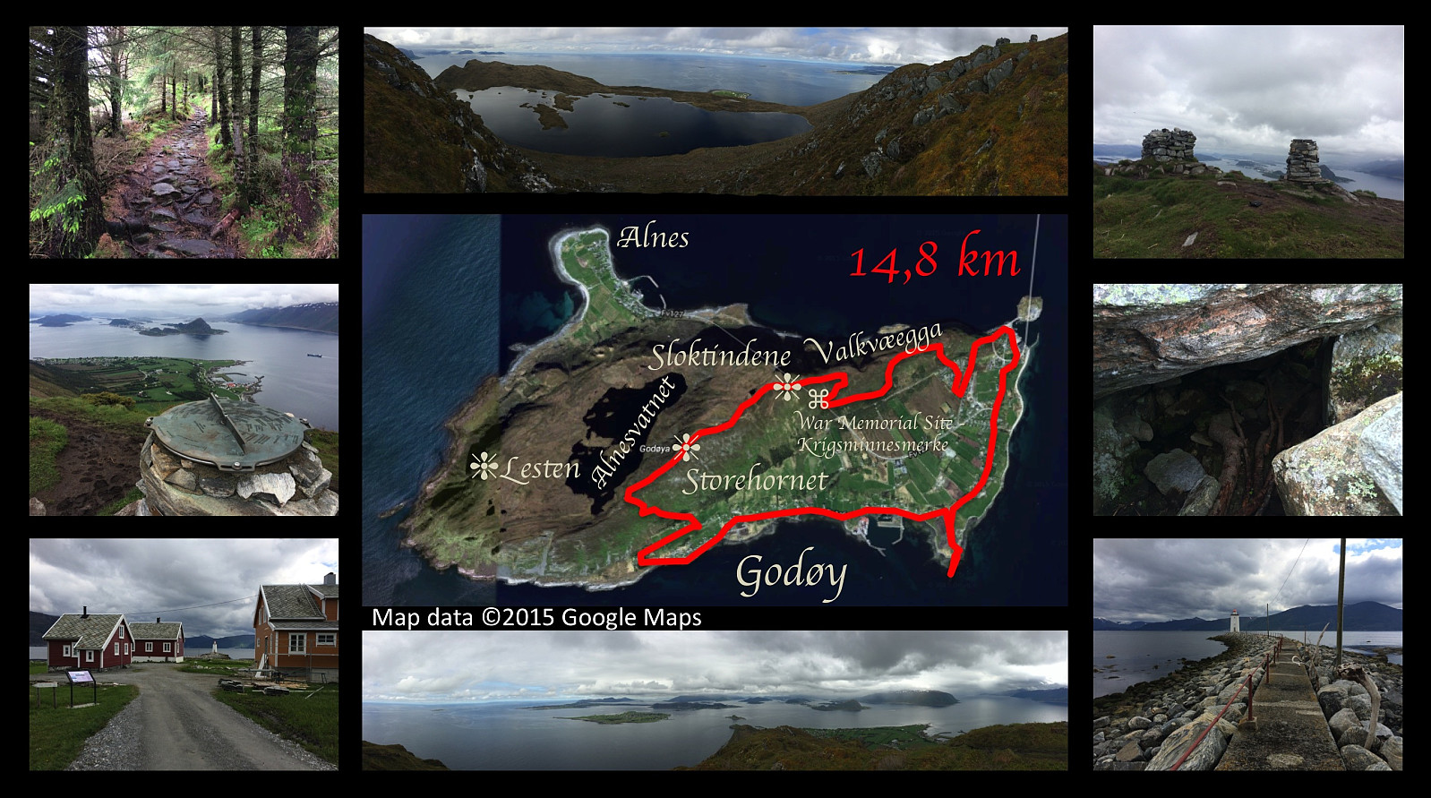 On this day I went for yet another hike on the mountain of the island Godøy, close to were we're living. This time I set out from a place called Djuv (or Juv) on the south side of the Island, and climbed towards the summit of the island, i.e. the peak called Storhornet. From Storhornet I took a somewhat peculiar way northeastwards, however, following first a little edge downwards to a viewpoint overlooking the southern and eastern parts of the island. From this spot I climbed back up to the pond called Lillevatnet, however, and then onto the peak called Sloktinden (there is actually about three peaks that are called Sloktindane [in plural form] by the locals, hence the singular form Sloktinden is something you're not likely to hear apart from here on Peakbook; anyway I climbed onto the easternmost >>>
