Arkiv - dato
Arkiv - aktivitet
-
Annen tur (1)
- Ekspedisjon (1)
-
Annen vintertur (10)
- Trugetur (10)
- Fottur (228)
-
Klatring (8)
- Alpin klatring (7)
- Miksklatring (1)
-
Skitur (49)
- Randonnée/Telemark (49)
-
Sykkeltur (2)
- Terrengsykling (1)


Lister jeg samler etter
-
Romsdal ≥ 100m pf.
(134/301)
 44%
44% -
Sunnmøre ≥ 100m pf.
(78/531)
14%
-
Norges 1000 største fjell målt i primærfaktor
(52/1000)
5%

Another Hike to the "Big Horn" on Godøy Island
- Dato:
- 26.09.2015
- Turtype:
- Fottur
- Turlengde:
- 3:48t
- Distanse:
- 9,7km
 On this day I had another hike on the mountains of the island Godøy in Giske Municipality in Møre & Romsdal County in western Norway with my son Dag. We had a really nice hike; the pictures above speaks for themselves. The hike is pretty much identical to the one I made on May 2nd 2015. For a short tour description, see my short summary on that date, and for a map, open the GPS tracking! We parked at Hestevika Parking Lot, from where we followed the mountain path up to Lake Alnesvatnet, which is located 250 m.a.m.s.l. We next followed the mountain edge westwards to a ridge that extends northwards from Mount Storhornet, and then we just continued along this ridge up to the summit. Net, we descended the rather steep path on the west side of Storhornet, and climbed up Mount Lesten, thus >>>
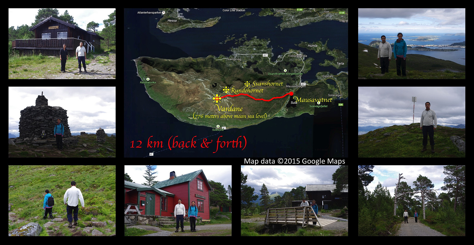
Encircling the Southern Part of Mt. Sulafjellet.
- Dato:
- 12.09.2015
- Turtype:
- Fottur
- Turlengde:
- 4:15t
- Distanse:
- 13,1km
 On this day I had another nice hiking trip on Mount Sulafjellet with my oldest son and one of his friends. This time we took a different route from what we've done on previous occasions; one that offers an awesome view in a southward direction. We set out from the parking lot at Mauseidvatnet as we've done before, and followed the gravel road through the forest past the cabin called Taustuhytta and up to the one called Rollonhytta . From there we continued along the mountain path that we had used before, up to the summit of the island, which is called Tverrfjellet or Vardane ; making sure though, to take a few minutes even to mount the peak called Rundehornet, so that I could tell people that I had been there also.
From Vardane we descended in southwest direction towards Sulabakkhornet, and then >>>
On this day I had another nice hiking trip on Mount Sulafjellet with my oldest son and one of his friends. This time we took a different route from what we've done on previous occasions; one that offers an awesome view in a southward direction. We set out from the parking lot at Mauseidvatnet as we've done before, and followed the gravel road through the forest past the cabin called Taustuhytta and up to the one called Rollonhytta . From there we continued along the mountain path that we had used before, up to the summit of the island, which is called Tverrfjellet or Vardane ; making sure though, to take a few minutes even to mount the peak called Rundehornet, so that I could tell people that I had been there also.
From Vardane we descended in southwest direction towards Sulabakkhornet, and then >>>
To Eltrane, Far West on the Plateau of Mt. Sulafjellet
- Dato:
- 29.08.2015
- Turtype:
- Fottur
- Turlengde:
- 7:20t
- Distanse:
- 24,9km
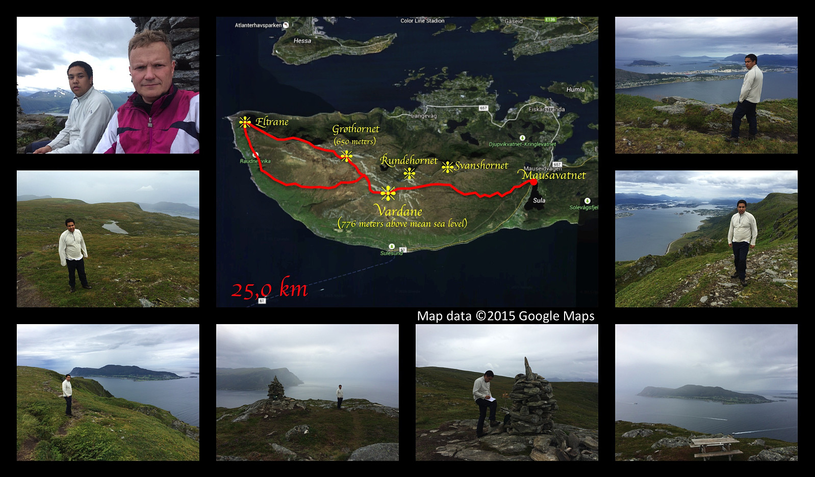 This weekend we had a really long hiking trip on Sulafjellet mountain. We started out from lake Mauseidvatnet, and went up to the highest point of the mountain as we've done on several previous occations; and from there we went on to the westmost part of Sula island, to a part of the mountain that is called Eltrane. To get there, we just followed a path along the nordthern edge of the mountain plateau that comprises most of the western part of the island. The path was nice, easy to spot, and not at all difficult to walk. We chose a different path for our return, however, as I had seen a track that was marked out on my hiking map. That track, however, proved to be overgrown by grass and heather, and it was very difficult to follow the path that had once been there. It seemed that this track >>>
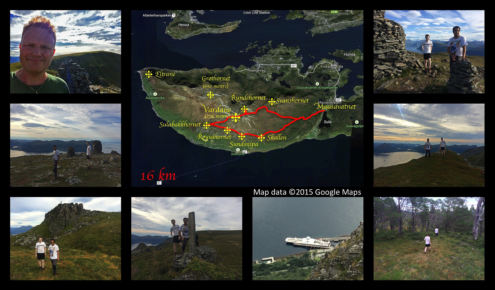
On Three Peaks of Mount Sulafjellet with my Son
- Dato:
- 15.08.2015
- Turtype:
- Fottur
- Turlengde:
- 5:47t
- Distanse:
- 16,9km
 I went for a cool trip on mount Sulafjellet along with my son Dag this afternoon. We started out from the parking place by the lake Mausavatnet as we've done on previous occasions, and walked past the well known mountain cabin Rollonhytta up to the mountain peak commonly reffered to as Vardane (776 meters above main sea level), though the real name is actually Tverrfjellet or just Sulafjellet from Sula, the name of the island on which the mountain is located [fjell = mountain]. We thereafter descended from Vardane as we headed towards another peak, Grøthornet, located 650 mamsl. From Grøthornet we descended quite a bit towards the village Langevåg, until we found a rather steep track that could take us up to the mountain peak called Svanshornet (552 mamsl). From Svanshornet we followed another >>>
Hiking Mount Sulafjellet with a son and a daughter.
- Dato:
- 08.08.2015
- Turtype:
- Fottur
- Turlengde:
- 3:44t
- Distanse:
- 12,0km
 I had on this day a really nice trip on the mountain Sulafjellet with my oldest son and my oldest daughter, aiming for the peak called Vardane. I also made the very same trip two months and two days earlier with my two sons and my cousin Savanna. On that day we had showers of hail and rain on the trip, and there was still a substantial amount of snow in the track. Even today we had just a very little bit of rain as we started on our descent back down from the mountain, but that didn't last for long; and the temperature was very different from what it was back in the beginning of june...
Hiking to "The Pulpit Rock" in Rogaland County
- Dato:
- 03.08.2015
- Turtype:
- Fottur
- Turlengde:
- 1:18t
- Distanse:
- 4,0km
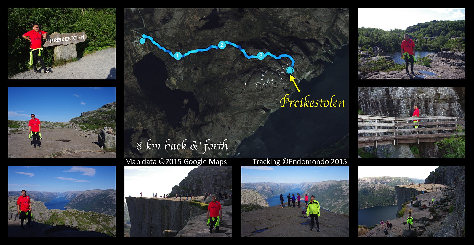 This afternoon I had a nice hike to the mountain plateau called The Pulpit Rock, in Norwegian Preikestolen. Weather was fabulous, it was actually so hot we needed to bring along a bottle of water each. It's a walk of about 4 km only (in each direction) from the parking area. Preikestolen is among the most famous tourist attractions in Norway, and has an estimated number of more than 200.000 visitors per year; hence a rather nice stone track has been made for the hikers, though it is, I have to say, a bit pebbled.
Encircling the western aspect of the Island Godøy
- Dato:
- 24.05.2015
- Turtype:
- Fottur
- Turlengde:
- 4:47t
- Distanse:
- 14,8km
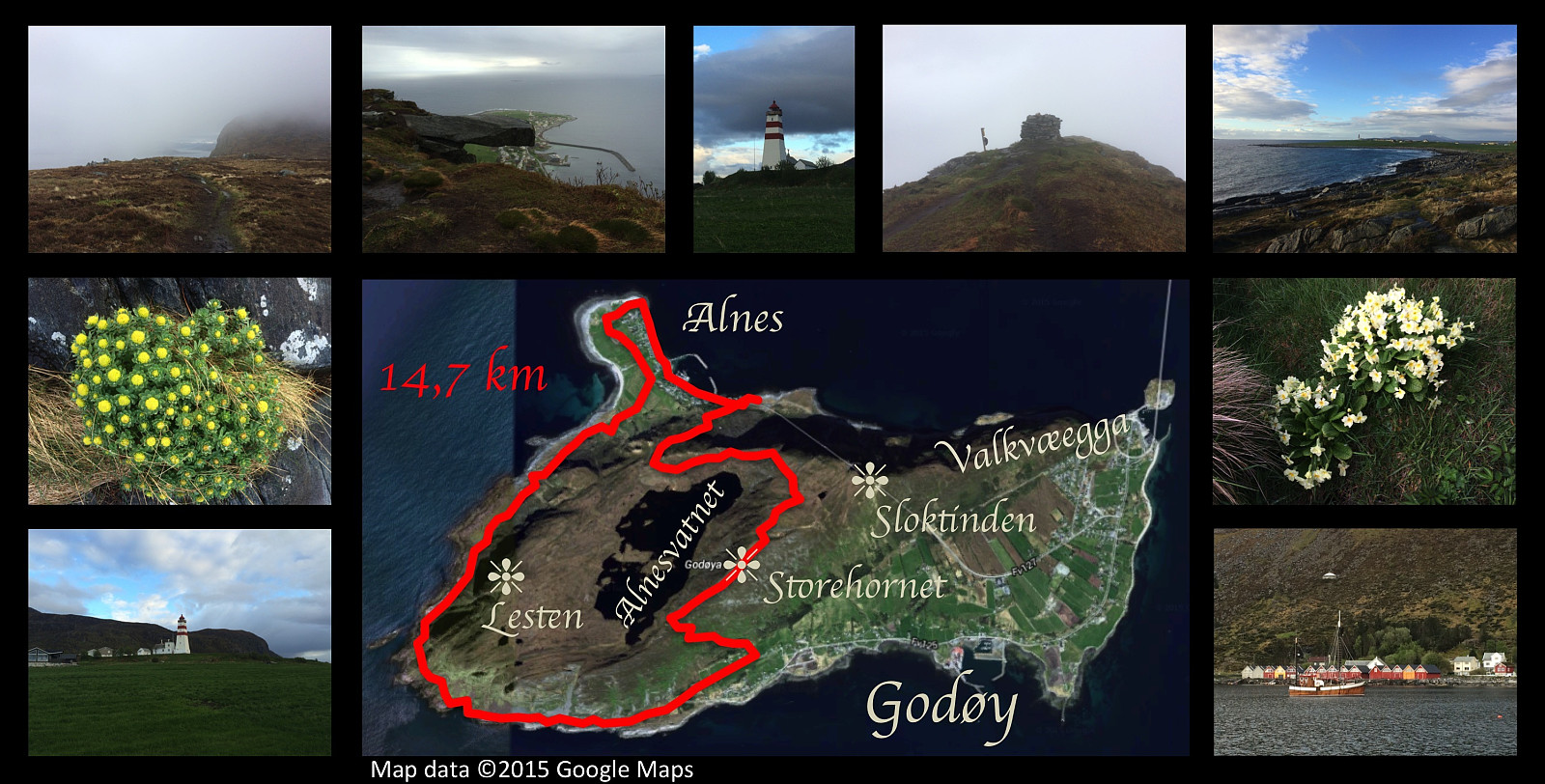 I had yet one hiking trip on the mountain of Godøy island this day. The weather was foggy and cold, and it was quite a wet experience; but I really needed to combust some calories after I attended the celebration of my mother's 70th anniversary the previous day. I climbed up from the promontory Alnes, up to the peak of Storhornet, then descended on the other side of the island, down to a place called Djuv. From there I followed the sea shore of the southern and western side of the island, back to Alnes. Due to the rough terrain, this part of the trip was definitely the hardest, despite the fact that the route mostly follows sea level. Upon arrival at Alnes, I followed the seashore around the promontory, and even stopped to shoot some photos of the picturesque lighthouse that is there. This >>>
Hybrid-trip (bike and hike) to Mount Lyderhorn.
- Dato:
- 14.05.2015
- Turtype:
- Fottur
- Turlengde:
- 1:46t
- Distanse:
- 4,6km
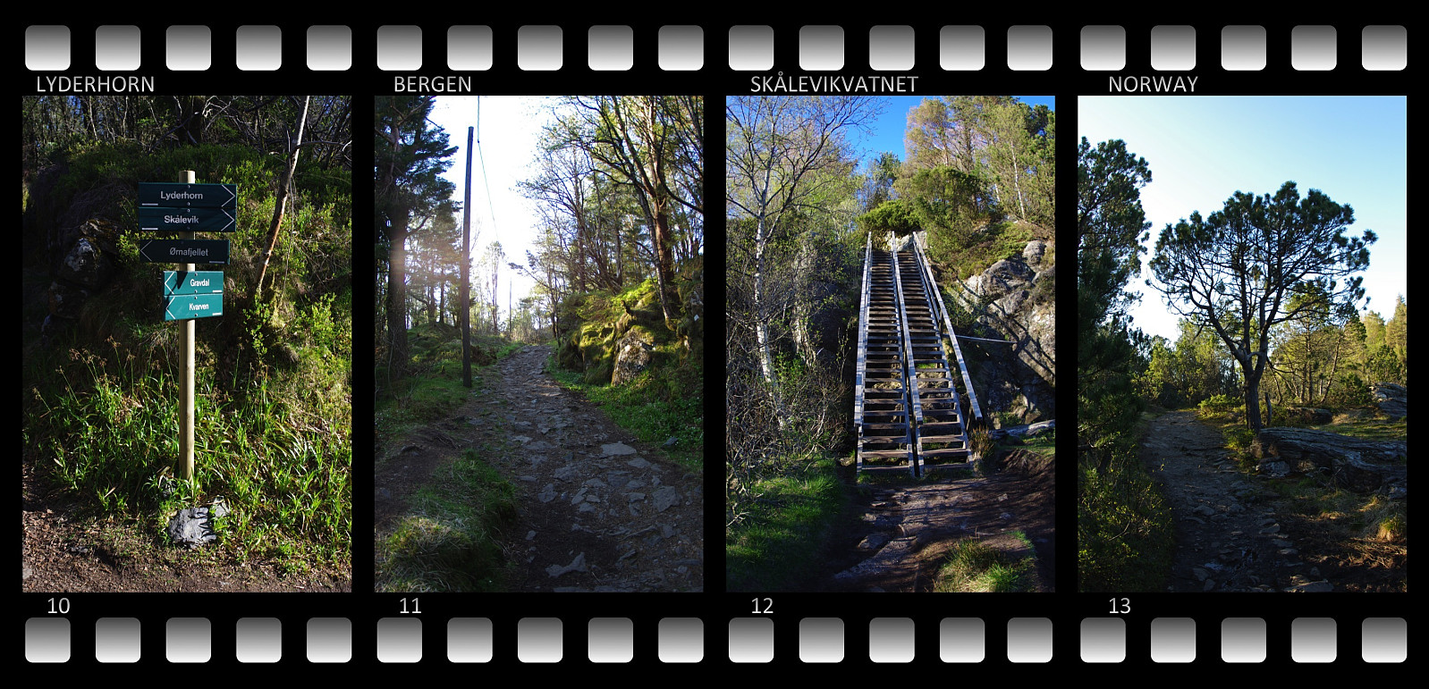 On this beautiful day in the month of May I had a splendid afternoon/evening trip up to the summit of mount Lyderhorn just west of the city of Bergen. I went by bicycle as far up as possible, to an altitude of about 212 meters above sea level (blue line on the image above); where I locked the bike to a fence and continued on foot (red line on the image). There is actually a narrow, but nice road up to a military installation at this altitude, quite nice for bicycling. A forest track then leads a few metres ahead to an escarpment, where some nice stairs have been built, that'll take you down to a lake or a pond called Skåleviksvatnet. From there a mountain track leads right to the summit of the mountain. The summit is located at an elevation of 396 meters. Had wonderful weather conditions, >>>
On Mount Løvstakken with my Son Dag
- Dato:
- 10.05.2014
- Turtype:
- Fottur
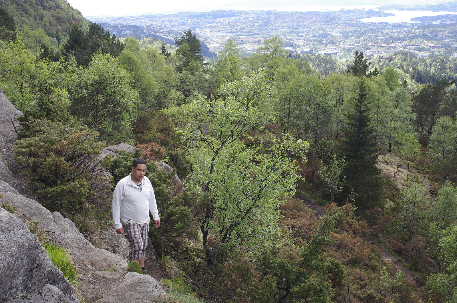 The city of Bergen has traditionally been called The City Between Seven Mountains, though there’s traditionally also been a dispute as to which of the many mountains around the city actually comprises the seven. Nevertheless, Mount Løvstakken is generally agreed upon to be one of the seven, and I had therefore had a desire for some time to visit this mountain. I had been working in Bergen for a little less than a year at this time, despite living in a different part of Norway; and as my oldest son was visiting me in Bergen this weekend, I suggested to him that we ascend Mount Løvstakken on this day.
We went by car from my Bergen apartment to the valley between Mount Løvstakken and Mount Olsokfjellet, i.e. to a location called Melkeplassen, and started trekking from there. The trail that >>>
The city of Bergen has traditionally been called The City Between Seven Mountains, though there’s traditionally also been a dispute as to which of the many mountains around the city actually comprises the seven. Nevertheless, Mount Løvstakken is generally agreed upon to be one of the seven, and I had therefore had a desire for some time to visit this mountain. I had been working in Bergen for a little less than a year at this time, despite living in a different part of Norway; and as my oldest son was visiting me in Bergen this weekend, I suggested to him that we ascend Mount Løvstakken on this day.
We went by car from my Bergen apartment to the valley between Mount Løvstakken and Mount Olsokfjellet, i.e. to a location called Melkeplassen, and started trekking from there. The trail that >>>
