Arkiv - dato
Arkiv - aktivitet
-
Annen tur (1)
- Kajakkpadling (1)
-
Annen vintertur (4)
- Trugetur (4)
- Fottur (740)
-
Skitur (4)
- Fjellskitur (4)
-
Sykkeltur (137)
- Blandet sykling (51)
- Gatesykling (9)
Arkiv - Etter geografi
"Peakbookvenner"


Lister jeg samler etter
-
Bergen ≥ 50m pf. og ≥ 100 m.o.h.
(87/89)
 97%
97% -
Most dominating tops of the Bergen peninsula
(68/75)
90%
-
Utvalgte topper og turmål i Bergen
(316/350)
90%
-
Alle topper i Bergen
(357/398)
89%
-
Opptur Bergen
(100/113)
88%
-
De syv fjell rundt Bergen
(6/7)
85%
-
Sund ≥ 50m pf.
(14/18)
77%
-
Os ≥ 50m pf.
(25/34)
73%
-
Søyler (fastmerker) i Bergen
(68/100)
68%
-
Fjell ≥ 50m pf.
(21/32)
65%

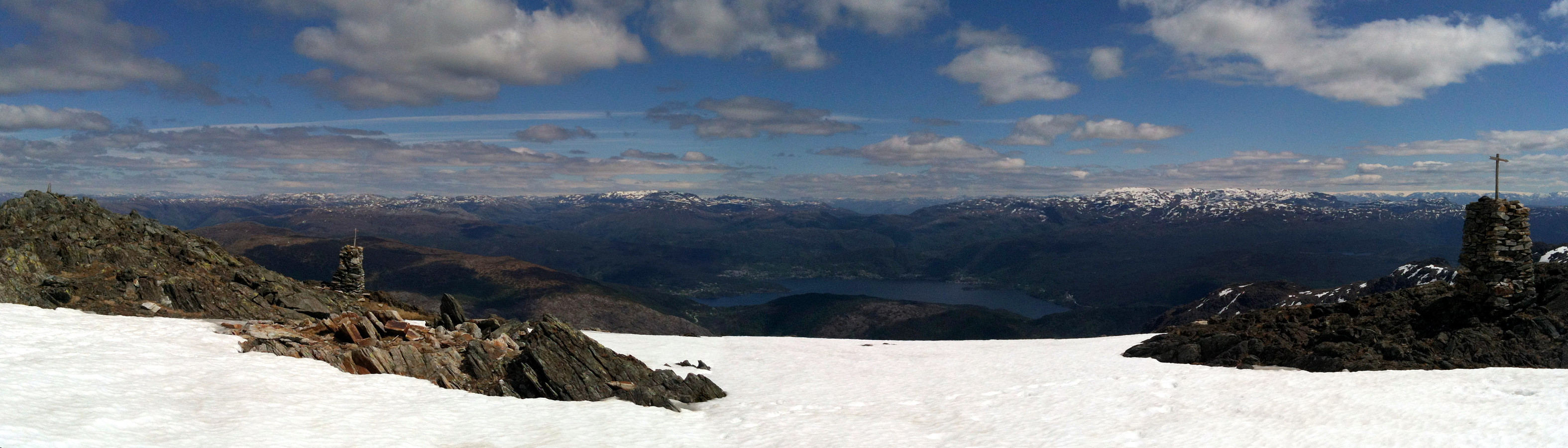
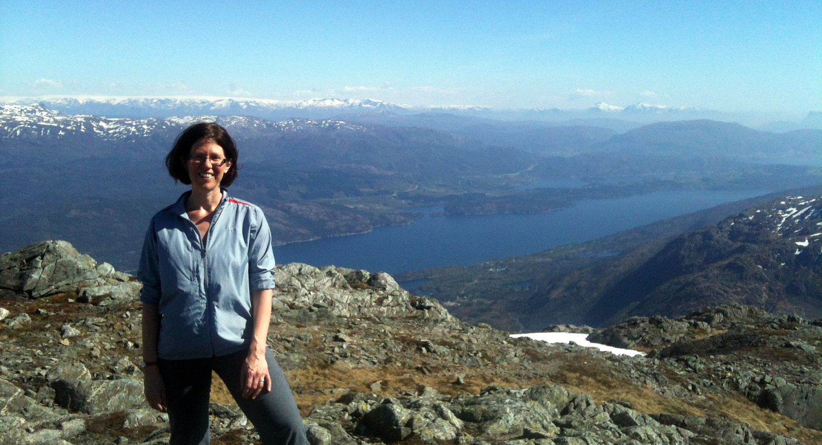
Sveningen from Midseterfjellet
- Dato:
- 02.08.2015
- Turtype:
- Fjelltur
- Turlengde:
- 6:15t
- Distanse:
- 20,1km
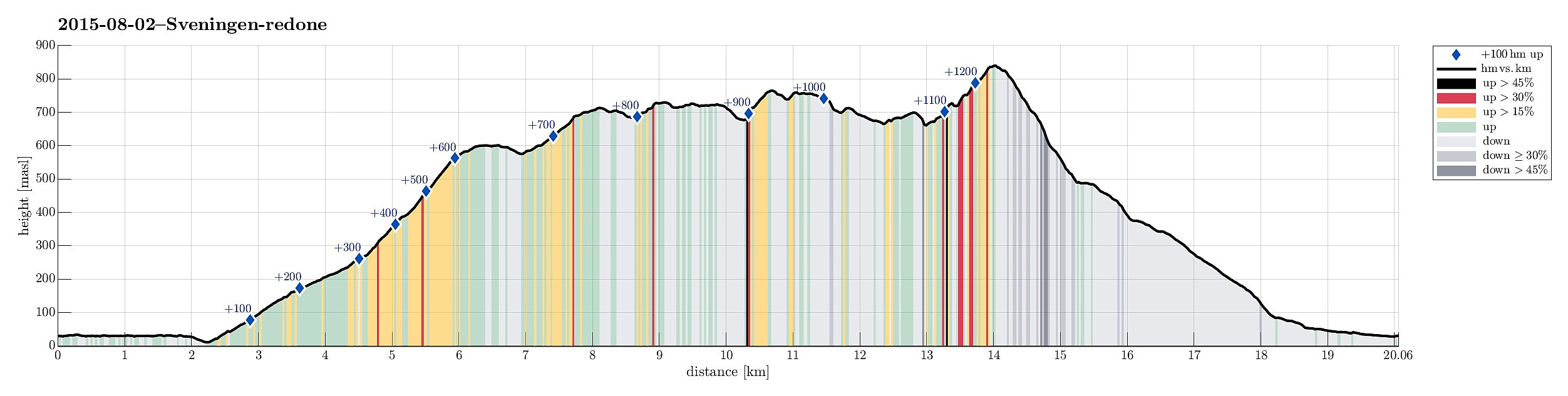 We parked our car at the end of Øvredalsvatnet (in Øvredalen) and walked back (southwards) along the lake to get to our starting point for the hike over the ridge (in Løyningdalen, right south of where Øvredalesvatnet "ends"). We then walked up the narrow road, which leads up to Midsætret, where a small number of houses assemble. From there, we first followed (for a short stretch, only) a forrest road, which leads mostly westwards, before then taking the hiking path that leads up to Midseterfjellet. First, we hiked in the forrest, but as soon as we left the trees behind, nice views opened, first mostly in western direction. The approximately 15 degrees Celsius were comfortable hiking weather -- in the beginning, however, it rained freshly melted snow, which brought the thought >>>
Via Gråfjellet towards Sveningen
- Dato:
- 05.10.2014
- Turtype:
- Fjelltur
- Turlengde:
- 6:30t
- Distanse:
- 18,1km
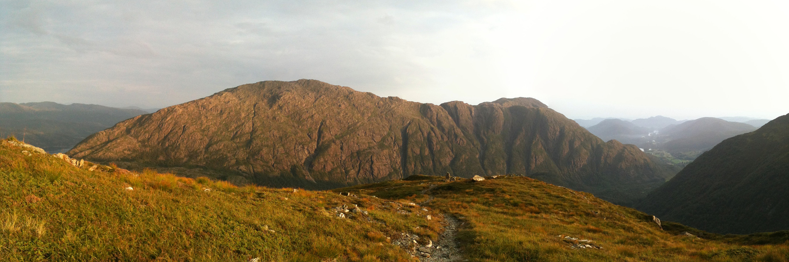
 We parked the car in Løyningdalen, right next to the street into Øvredalen. We then crossed the river (bridge) and continued into Stordalen. Following Stordalen, we passed by Gråfjellet and climbed up to Midtfjellet first. From there, we changed over to Gråfjellet, going a bit back in direction. From Gråfjellet, we then descended to Leina and followed the ridge in direction Baggeskaret. Most of this is without any path and you better have a bit of an adventure-spirit to try this connection. From there we continued along the ridge, first via Selsfjellet and then to Utløfjellet, before we started a quite steep ascent towards Sveningen. Basically, most of this tour was along the border between Os and Samnanger. See the image for the part of the trip which was (too?) steep. Maybe, >>>
Sydpolen
- Dato:
- 24.05.2014
- Turtype:
- Fjelltur
- Turlengde:
- 4:00t
- Distanse:
- 11,9km
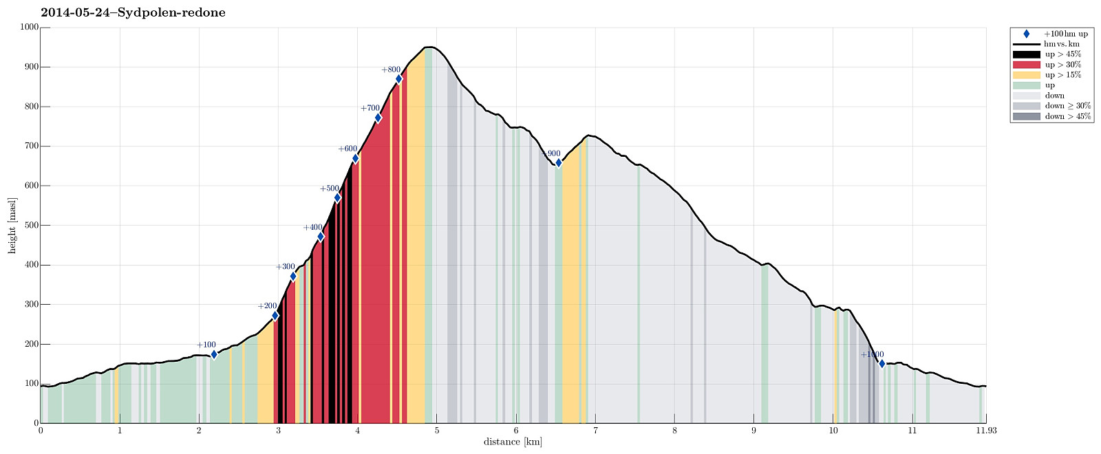 Sydpolen from Brekkjedalen is again and again a very nice tour!
Web page WestCoastPeaks.com provides useful information about S. Gullfjellstoppen (Sydpolen)
and also Petter Bjørstad has a useful page about Sydpolen .
Sydpolen from Brekkjedalen is again and again a very nice tour!
Web page WestCoastPeaks.com provides useful information about S. Gullfjellstoppen (Sydpolen)
and also Petter Bjørstad has a useful page about Sydpolen .
Sveningen
- Dato:
- 27.04.2014
- Turtype:
- Fjelltur
- Turlengde:
- 3:00t
- Distanse:
- 13,1km
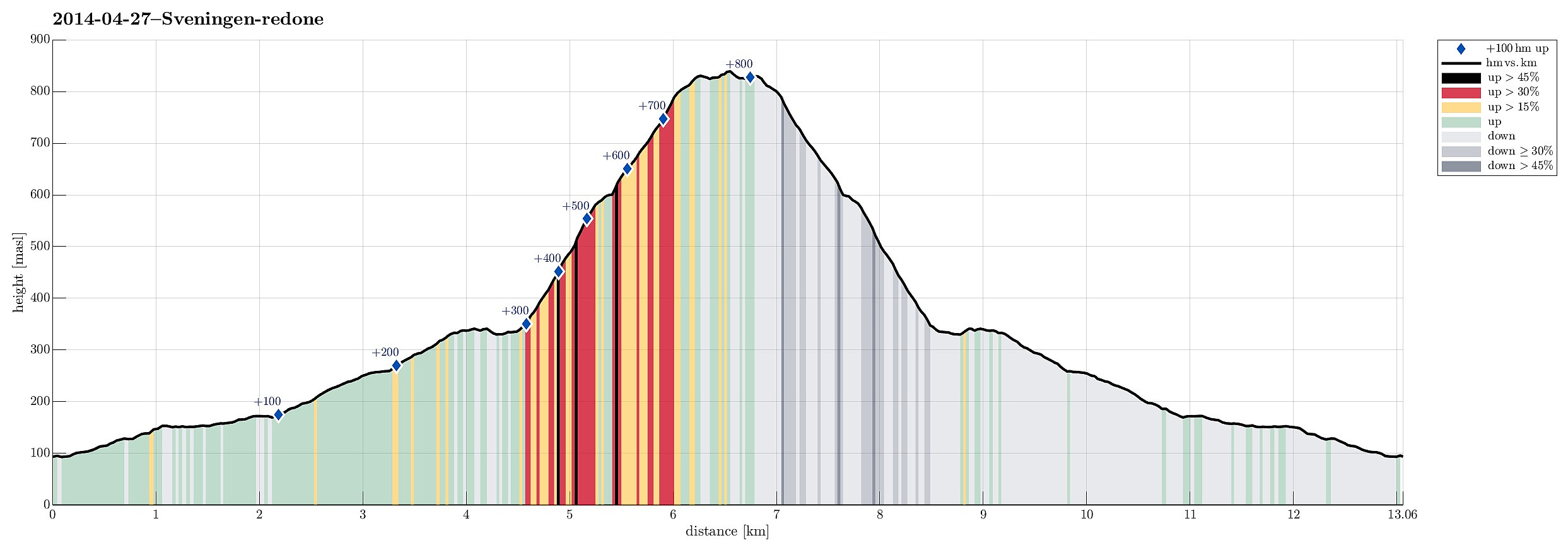 This time, we took a new route to the top: from Brekkjedalen -- that's actually very attractive and rewarding!
Web page WestCoastPeaks.com provides useful information about Sveningen, Søtefjellet, Sauskolten, Rindafjellet, and Midtsæterfjellet
and also Petter Bjørstad has a useful page about Sveningen .
This time, we took a new route to the top: from Brekkjedalen -- that's actually very attractive and rewarding!
Web page WestCoastPeaks.com provides useful information about Sveningen, Søtefjellet, Sauskolten, Rindafjellet, and Midtsæterfjellet
and also Petter Bjørstad has a useful page about Sveningen .
Sydpolen
- Dato:
- 23.08.2013
- Turtype:
- Fjelltur
- Turlengde:
- 3:00t
- Distanse:
- 13,3km
 Great quick evening walk from Brekkjedalen, up Sydpolen and then down again (via Toro) -- great walk-out in fantastic nature! :-)
Selected photos are available as Google photo album .
Web page WestCoastPeaks.com provides useful information about S. Gullfjellstoppen (Sydpolen)
and also Petter Bjørstad has a useful page about Sydpolen .
Great quick evening walk from Brekkjedalen, up Sydpolen and then down again (via Toro) -- great walk-out in fantastic nature! :-)
Selected photos are available as Google photo album .
Web page WestCoastPeaks.com provides useful information about S. Gullfjellstoppen (Sydpolen)
and also Petter Bjørstad has a useful page about Sydpolen .
Gullfjellet
- Dato:
- 09.06.2013
- Turtype:
- Fjelltur
- Turlengde:
- 4:30t
- Distanse:
- 13,8km
 Great hike from Osavatnet (315m) to Gullfjelltoppen (987m) with the boys and then down, again, via Redningshytten. The ascent via Ronamanen (leaving the main track, which would connect to Redningshytten from Osacatnet, a few meters above Svartavatnet to the left, then along Småhaugane and up the ridge, passing Markskilfossen) is really a good alternative to the main "Autobahn" up Gullfjellet! :-)
Sydpolen
- Dato:
- 26.05.2013
- Turtype:
- Fjelltur
- Turlengde:
- 3:00t
- Distanse:
- 12,0km
 Starting from the end of Hausdalen, first a bit through Brekkedalen, then up to Toro, before continuing to Sydpolen -- a really great tour!
Web page WestCoastPeaks.com provides useful information about S. Gullfjellstoppen (Sydpolen)
and also Petter Bjørstad has a useful page about Sydpolen .
Starting from the end of Hausdalen, first a bit through Brekkedalen, then up to Toro, before continuing to Sydpolen -- a really great tour!
Web page WestCoastPeaks.com provides useful information about S. Gullfjellstoppen (Sydpolen)
and also Petter Bjørstad has a useful page about Sydpolen .
Sveningen
- Dato:
- 10.10.2010
- Turtype:
- Fjelltur
- Turlengde:
- 4:00t
- Distanse:
- 11,5km
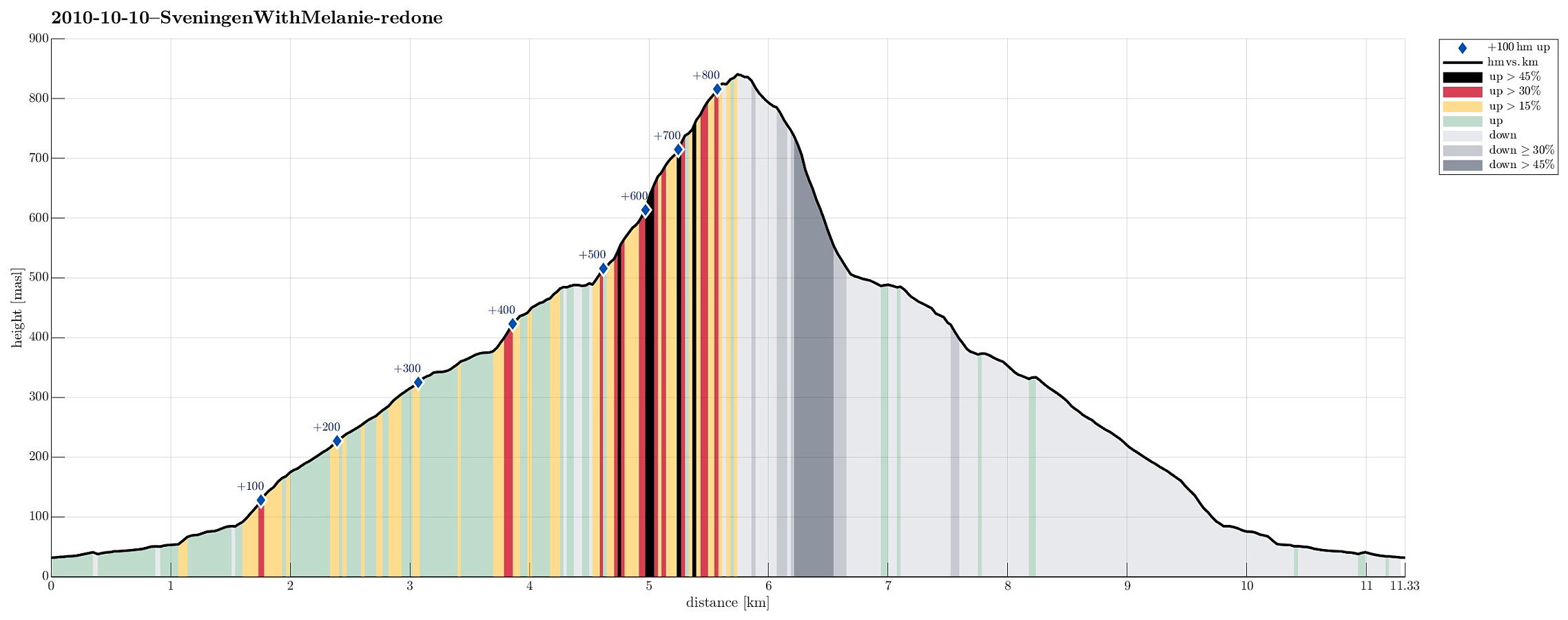 Nice autumn hike up to and down from Sveningen!
Selected photos are available as Google photo album .
Web page WestCoastPeaks.com provides useful information about Sveningen, Søtefjellet, Sauskolten, Rindafjellet, and Midtsæterfjellet
and also Petter Bjørstad has a useful page about Sveningen .
Nice autumn hike up to and down from Sveningen!
Selected photos are available as Google photo album .
Web page WestCoastPeaks.com provides useful information about Sveningen, Søtefjellet, Sauskolten, Rindafjellet, and Midtsæterfjellet
and also Petter Bjørstad has a useful page about Sveningen .
