Arkiv - dato
Arkiv - aktivitet
-
Annen tur (1)
- Kajakkpadling (1)
-
Annen vintertur (4)
- Trugetur (4)
- Fottur (740)
-
Skitur (4)
- Fjellskitur (4)
-
Sykkeltur (137)
- Blandet sykling (51)
- Gatesykling (9)
Arkiv - Etter geografi
"Peakbookvenner"


Lister jeg samler etter
-
Bergen ≥ 50m pf. og ≥ 100 m.o.h.
(87/89)
 97%
97% -
Most dominating tops of the Bergen peninsula
(68/75)
90%
-
Utvalgte topper og turmål i Bergen
(316/350)
90%
-
Alle topper i Bergen
(357/398)
89%
-
Opptur Bergen
(100/113)
88%
-
De syv fjell rundt Bergen
(6/7)
85%
-
Sund ≥ 50m pf.
(14/18)
77%
-
Os ≥ 50m pf.
(25/34)
73%
-
Søyler (fastmerker) i Bergen
(68/100)
68%
-
Fjell ≥ 50m pf.
(21/32)
65%

Storenuten and Vardane
- Dato:
- 14.06.2020
- Turtype:
- Fottur
- Turlengde:
- 4:30t
- Distanse:
- 9,3km
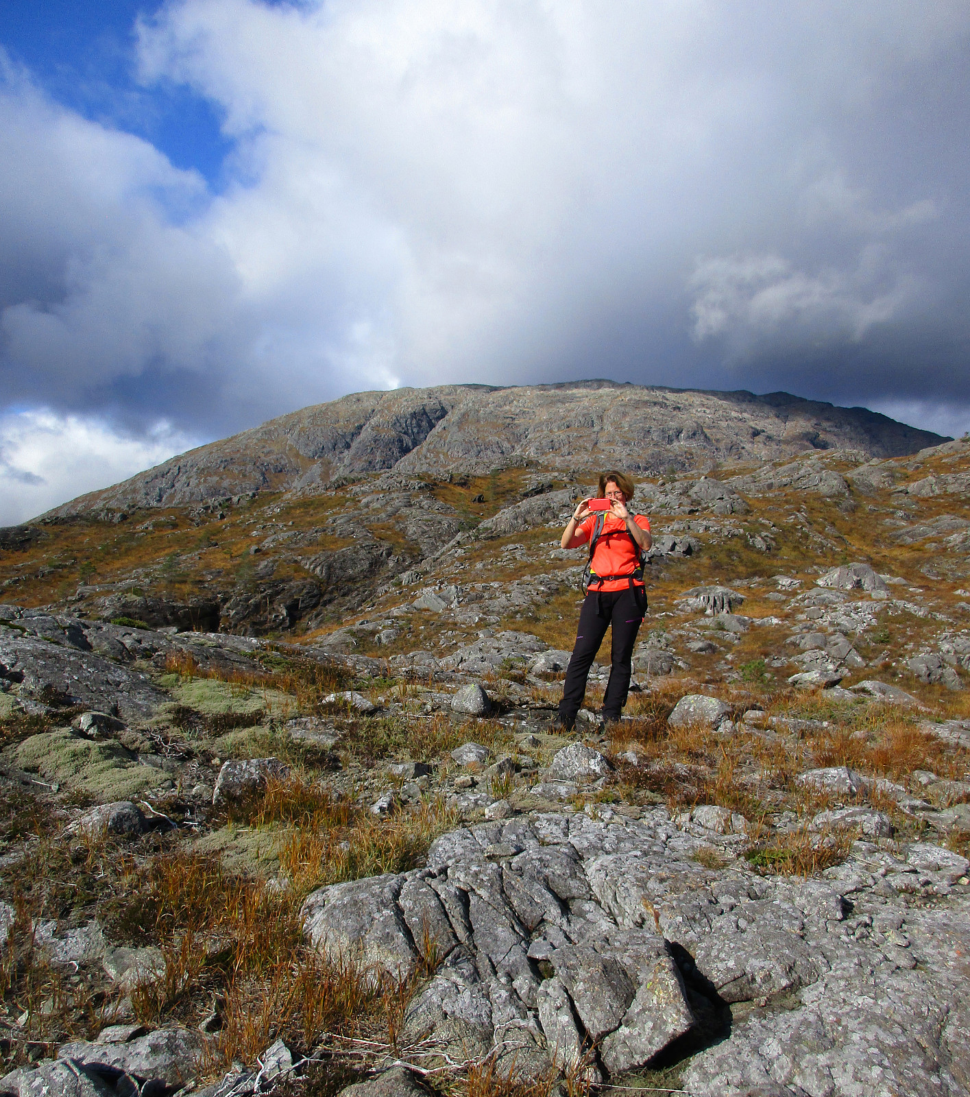
 We expected (for good reasons) a nice Sunday and thus aimed at a nice (new) hike! We had looked at Storenuten, south of Vaksdal, not very far from Bergen. Taking road E16 into the direction of Voss, we turned right in Vaksdal, after driving through Bogatunnelen. We then rounded Sørbø, in the south of Vaksdal, passing by the non-small church of Vaksdal. We then followed what previously must have been the main road to Bergen in southern direction, getting to Bogo within a bit. At Ytre Bogo we parked along Bogavegen and started our hike there. After a careful study of the map (at home), we aimed for Storenuten "as directly as possible". This, clearly, is non-trivial, without a trail, and should be planned carefully when considered! Alternatively, one may follow a nice trail, >>>
Sauafjellet from Rolvsvåg
- Dato:
- 29.09.2019
- Turtype:
- Fottur
- Turlengde:
- 4:00t
- Distanse:
- 8,3km
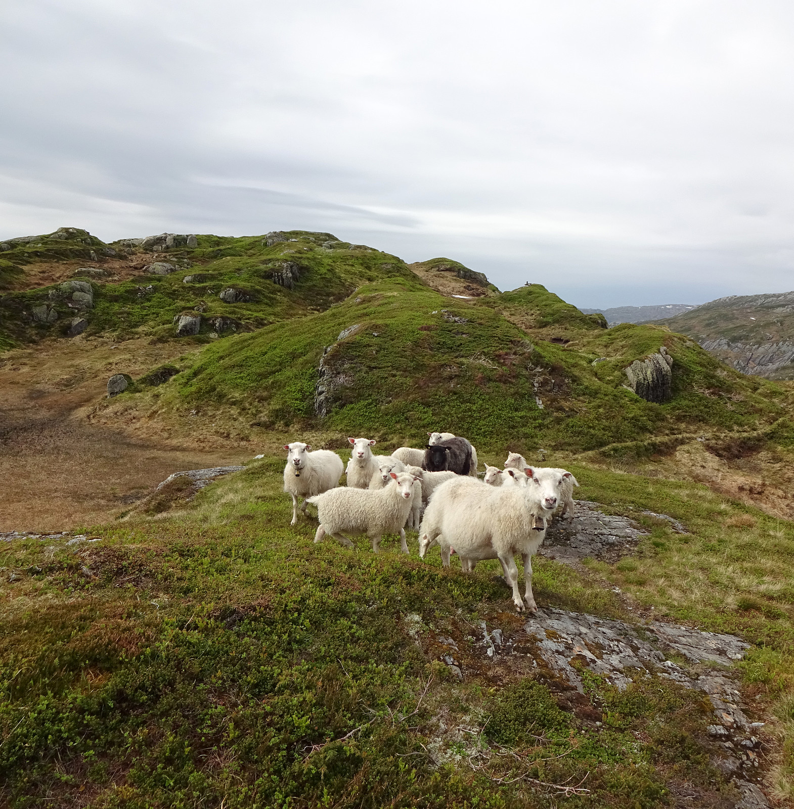
 For a long time, we had set Sauafjellet aside, keeping it for "another day". Today, we decided to give Sauafjellet a try. To make this a proper hike, we discussed several variants, eventually arriving at the plan to approach Sauafjellet from its south (from Rolvsvåg). Driving northwards on the western side of Samnangerfjorden (following road 579), we parked where Setravegen meets Solbjørgvegen and started our hike along Setravegen until we had passed the industrial area at Rolvsvåg. There we found a forest road that rounds Raudsteinshaugen before then leading northwards into the direction Øykjadalen. At about 110mosl, where the forest road ascends on the eastern side of the valley, we left the forest road and continued upwards to reach the ridge in the east of Øykjadalen, >>>
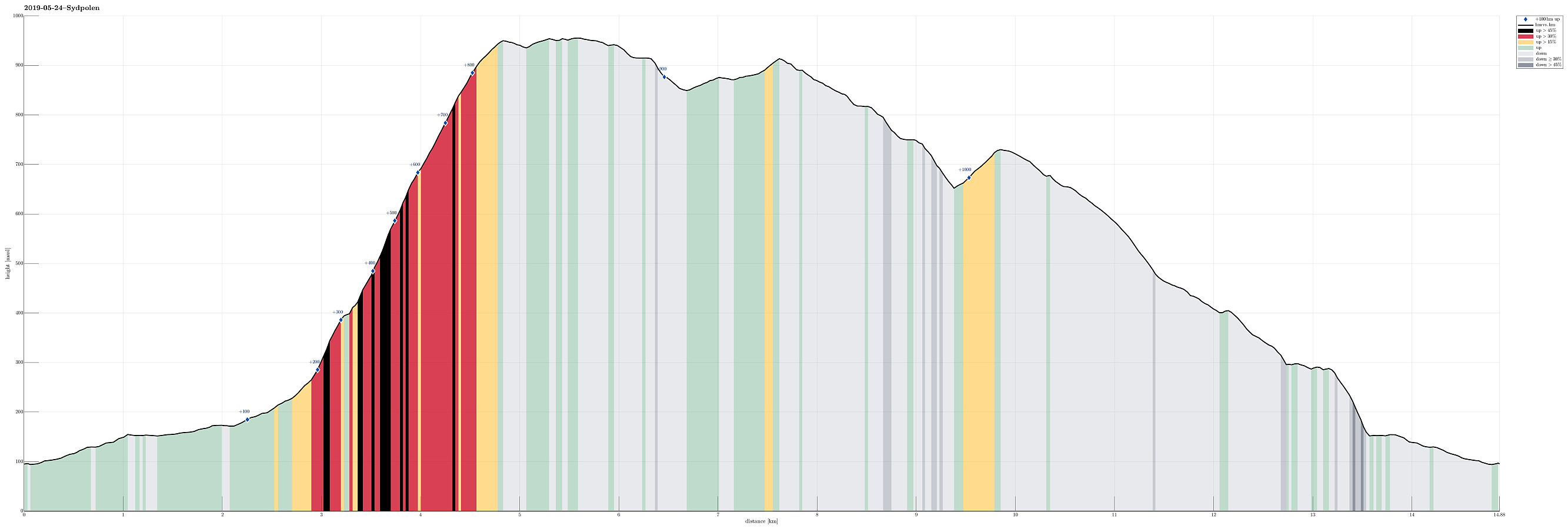
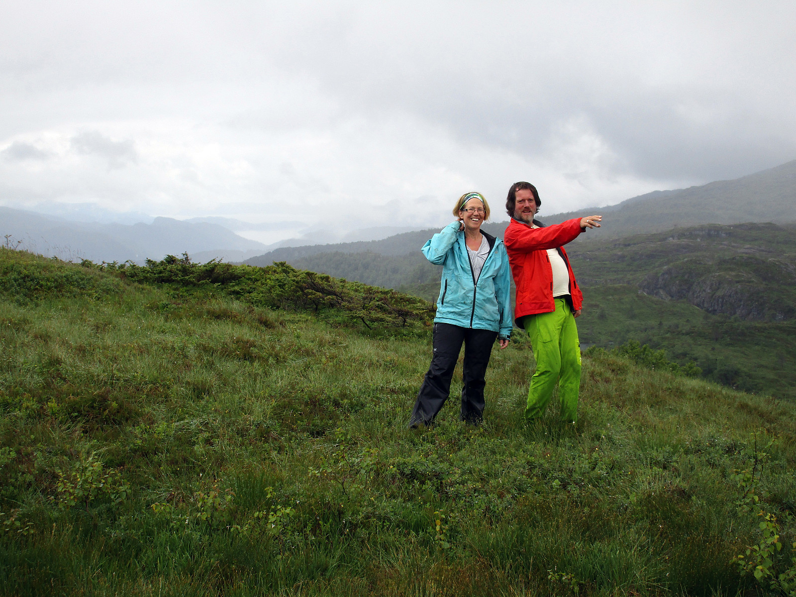
Sydpolen and Gullfjellet from Brekkedalen
- Dato:
- 24.05.2019
- Turtype:
- Fjelltur
- Turlengde:
- 5:15t
- Distanse:
- 14,9km
 Nice to have guests, who wish to go hiking in the mountains near Bergen! :-)
The original plan was to do this on Saturday, but since the weather forecast was much better on Friday afternoon, we arranged for this timeplan instead. We left Bergen with the car into the direction of Os (on E39). After coming by Kalandsvatnet, we turned left at about Kalandseidet to enter the relatively narrow road into Hausdalen. Driving Hausdalen all the way in, we arrived at the parking place near the beginning of Brekkedalen (at the very end of the road through Hausdalen). From there, we first walked along the gravel road into Brekkedalen (in eastern direction). We came by Sandane (a nice spot in Brekkedalen!) and also took the bridge over Tverrelva, coming down from the left/north, still continuing through >>>
Nice to have guests, who wish to go hiking in the mountains near Bergen! :-)
The original plan was to do this on Saturday, but since the weather forecast was much better on Friday afternoon, we arranged for this timeplan instead. We left Bergen with the car into the direction of Os (on E39). After coming by Kalandsvatnet, we turned left at about Kalandseidet to enter the relatively narrow road into Hausdalen. Driving Hausdalen all the way in, we arrived at the parking place near the beginning of Brekkedalen (at the very end of the road through Hausdalen). From there, we first walked along the gravel road into Brekkedalen (in eastern direction). We came by Sandane (a nice spot in Brekkedalen!) and also took the bridge over Tverrelva, coming down from the left/north, still continuing through >>>
Via Purkedalsgjelet to Kofta etc.
- Dato:
- 02.09.2018
- Turtype:
- Fjelltur
- Turlengde:
- 7:45t
- Distanse:
- 18,2km
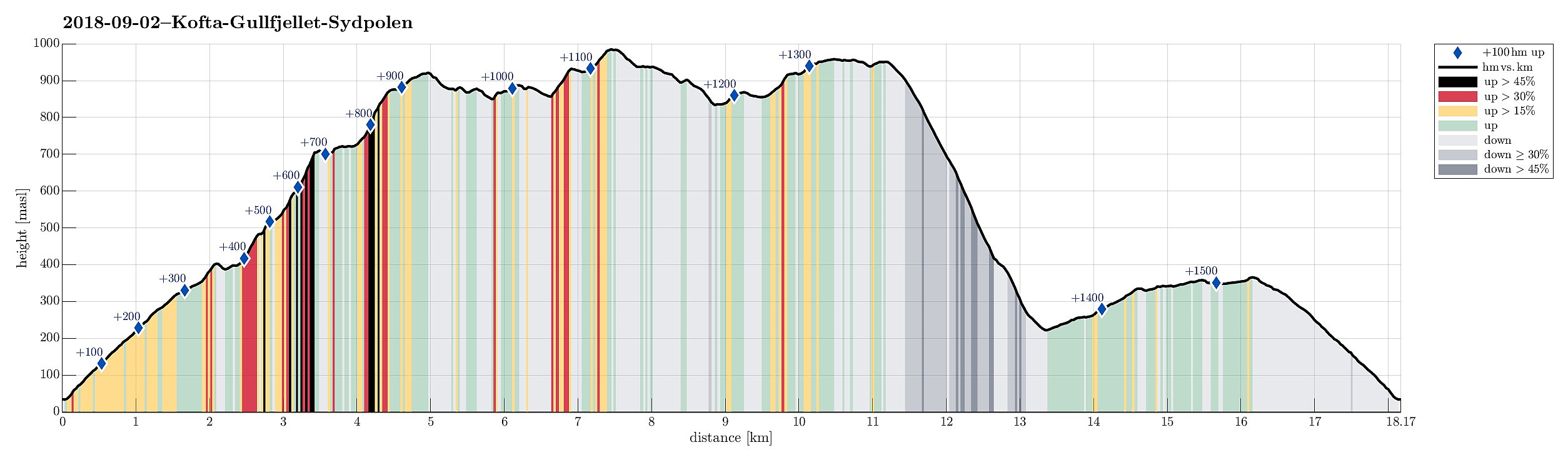 This hike, and in particular the part through Purkedalsgjelet up to Kofta, was one that asked for a careful preparation. It's recommended that you study the circumstances carefully and choose also the weather conditions appropriately. In order to enjoy this hike, you should (a) be at least somewhat experienced with hiking in the mountains around Bergen, in particular also without a path (finding your way, etc.) and (b) choose a dry day on which you can expect that there would not be too much water coming down Purkedalsgjelet (I'd rather not go this hike when snow is melting on Gullfjellet, or after some heavy rain). Take care (and enjoy)! :-)
We parked along the road from Os to Samnanger (#137), which passes Gullfjellet on its eastern (generally very steep) side. Actually, we first missed >>>
This hike, and in particular the part through Purkedalsgjelet up to Kofta, was one that asked for a careful preparation. It's recommended that you study the circumstances carefully and choose also the weather conditions appropriately. In order to enjoy this hike, you should (a) be at least somewhat experienced with hiking in the mountains around Bergen, in particular also without a path (finding your way, etc.) and (b) choose a dry day on which you can expect that there would not be too much water coming down Purkedalsgjelet (I'd rather not go this hike when snow is melting on Gullfjellet, or after some heavy rain). Take care (and enjoy)! :-)
We parked along the road from Os to Samnanger (#137), which passes Gullfjellet on its eastern (generally very steep) side. Actually, we first missed >>>
Geitanipa
- Dato:
- 08.07.2017
- Turtype:
- Fjelltur
- Turlengde:
- 2:00t
- Distanse:
- 4,8km
 We started from Langhelle, between Trengereid and Vaksdal, at the end of the paved (small and narrow) road, which winds up there from E16 near the fjord. We first walked up a little longer along the gravel road until the point, where it makes a sharp turn right, leading further up to Seterkokane. We then followed a forest trail that brought us further up (in southeastern direction) to the saddle between Trollaberget and Geitanipa. At about this saddle, we decided to not descend to the southern side, but instead to connect to Geitanipa, instead. While there was not really any path or trail to Geitanipa, we still managed to get there without major difficulties (Geitanipa is, in fact, a bit steep on its eastern side, so it is necessary to carefully choose a good spot for ascending to it). >>>
Tveitakvitingen from Tveita
- Dato:
- 09.10.2016
- Turtype:
- Fjelltur
- Turlengde:
- 7:00t
- Distanse:
- 16,4km
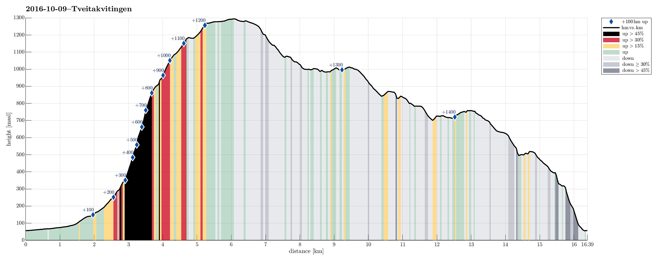 We took E16 from Bergen to Trengereid, then following road number 7 to Samnanger, before changing over to road number 48 right after Hagaåstunnelen. We passed through Eikelandsosen and continued to Holdhus, where we changed to a small road, which would lead us into the Tveita valley. Once there, we continued almost all the way in and parked near Bratthus, close to Indre Tveita. From there, we walked the rest of the road into the end of this nice valley, passing the last farm at Brekka soon after. The way continues into Tveitaskaret, where it becomes steep very soon (but easy to hike---mostly, because a gravel road has been constructed---probably to help maintaining a small power station that was opened in Tveitaskaret in 2009). At the end of the gravel road, one can further ascend through >>>
Sveningen from Hausdalen
- Dato:
- 12.06.2016
- Turtype:
- Fjelltur
- Turlengde:
- 6:30t
- Distanse:
- 13,5km
 This time, we had two cars, so we parked one at the very end of Hausdalen (where Brekkedalen starts). We then took the other car to get to our starting point, a little further out Hausdalen (near Samdalsvatnet, Tømmervika, Straumsrinden, Hausdalsvegen 425---about 3.4 km away from the parking at the very end of Hausdalen). This start point for the hike is not 100% obvious and one needs to know, where to leave the street in Hausdalen. One then drives just a few meters up a gravel road, before there is space for two or three cars on the left side. From there, we followed the forrest road, first over Straumsrinden (passing by Samdalsvatnet). On its southern / southwestern end, one uses two bridges to get over the stream that continues further out Hausdalen. Only shortly after, one crosses >>>
Sydpolen from Brekkedalen and more
- Dato:
- 04.06.2016
- Turtype:
- Fjelltur
- Turlengde:
- 5:30t
- Distanse:
- 14,7km
 We parked at the end of the road in Hausdalen, near the bridge to Brekkedalen. We then followed the gravel road into Brekkedalen, first, before leaving this road (to the left) and ascending to Sydpolen via the steep ridge that comes down into Brekkedalen. We have hiked this route several times before and always this part (up to Sydpolen from Brekkedalen) is a special (and nice!) hiking challenge. This time, my challenge doubled as the sole of one of my hiking shoes detached just after 100m up, or so. With a short cord that I took of my backbag, I managed to bind the loose sole back to my shoe (somehow), but hiking was definitely different, afterwards! :-) With this short delay, we ended up at Sydpolen a few minutes later than expected---still, we enjoyed this part of the hike very much, >>>
Krånipa, Holdhusfjellet, and Raudfjellet
- Dato:
- 22.11.2015
- Turtype:
- Fjelltur
- Turlengde:
- 3:00t
- Distanse:
- 10,6km
 I parked on a convenient parking spot (for several cars!) at Nordre Skulstad, not far from where the paved road ends (one could, probably, drive all the way up to the dam, but it's not far from there anyway). From there, I first walked up to the dam (on a gravel road), before I turned right, southwards, and there crossed the stream that comes down from Skulstadvatnet on a bridge right underneath the dam. On the other side, another gravel road winds along Skulstadvatnet towards Kråaustebotn. I followed this road until it turns "too much" left (in northeastern direction)---there, I decided to leave the road, using one of the minor ridges that run down from Krånipa towards Kråaustebotn in northern direction, aiming for the ridge that would bring me up to Krånipa. On the frozen >>>
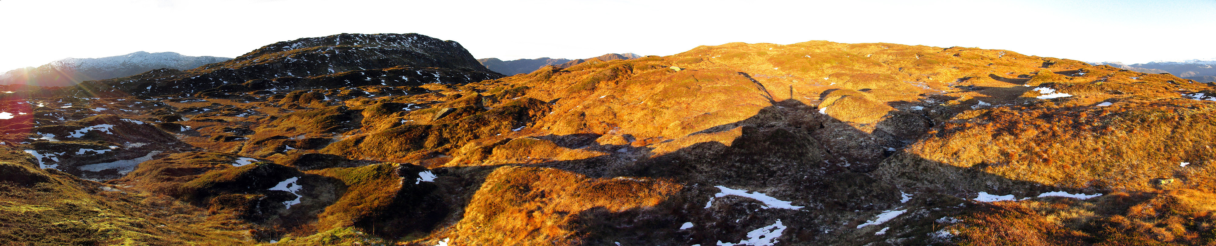
Sydpolen
- Dato:
- 18.10.2015
- Turtype:
- Fjelltur
- Turlengde:
- 4:30t
- Distanse:
- 14,6km
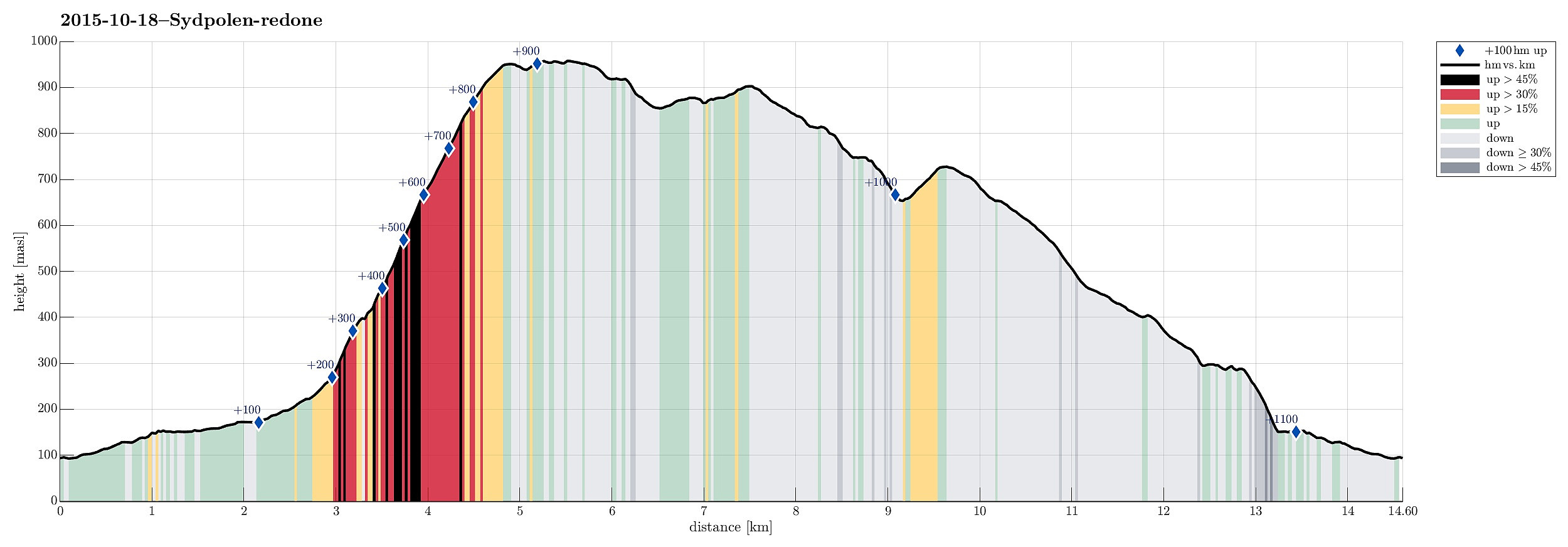 We parked at the end of Hausdalen and started with walking in Brekkjedalen (until a height of about 260mosl). Basically, where a power line mast stands close to the gravel road, a path diverts to the left, marking the beginning of the ascent to Sydpolen. Down in Brekkjedalen, late morning frost was still omnipresent, but after only a few meters of our ascent over the ridge upwards, we "entered" the sun and enjoyed a beautiful autumn day! It took us 60 mins. from the gravel road and up to the top of Sydpolen---not too bad, maybe! :-) From Sydpolen, after a short break, we continued in northeastern direction, rounding Gullfjelltjørnane in a counterclockwise manner. Near Gullfjellet (not Gullfjelltoppen), we connected to the main path that leads up and down Gullfjellet via Redningshytten. >>>
