Arkiv - dato
Arkiv - aktivitet
-
Annen tur (1)
- Kajakkpadling (1)
-
Annen vintertur (4)
- Trugetur (4)
- Fottur (740)
-
Skitur (4)
- Fjellskitur (4)
-
Sykkeltur (137)
- Blandet sykling (51)
- Gatesykling (9)
Arkiv - Etter geografi
"Peakbookvenner"


Lister jeg samler etter
-
Bergen ≥ 50m pf. og ≥ 100 m.o.h.
(87/89)
 97%
97% -
Most dominating tops of the Bergen peninsula
(68/75)
90%
-
Utvalgte topper og turmål i Bergen
(316/350)
90%
-
Alle topper i Bergen
(357/398)
89%
-
Opptur Bergen
(100/113)
88%
-
De syv fjell rundt Bergen
(6/7)
85%
-
Sund ≥ 50m pf.
(14/18)
77%
-
Os ≥ 50m pf.
(25/34)
73%
-
Søyler (fastmerker) i Bergen
(68/100)
68%
-
Fjell ≥ 50m pf.
(21/32)
65%

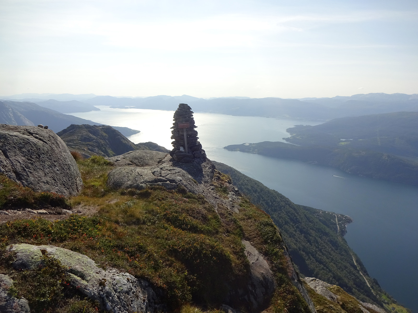
From Odda to Buardalen via Ruklenuten
- Dato:
- 03.08.2024
- Turtype:
- Fottur
- Turlengde:
- 8:00t
- Distanse:
- 12,1km
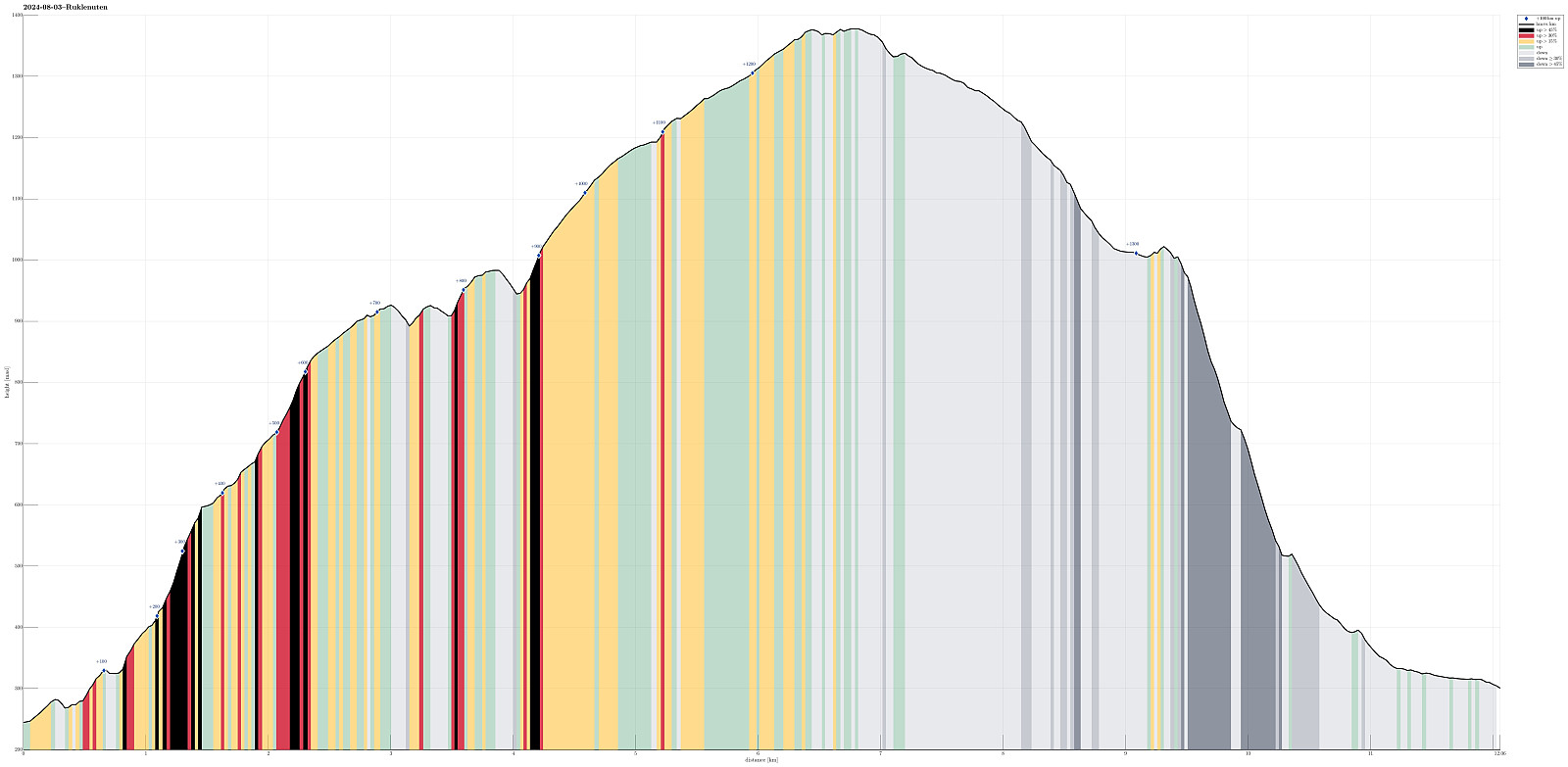 We wished to make a nice hike from Odda and found Eidesnuten as a worthwhile hiking target, promising nice views in multiple directions. Starting from Eidesåsen, some 250masl and about 150 heights meters above Eide in the south of Odda, we followed a very well-marked trail. Even though one may expect more hikers on such a well-treated trail, we did not meet anyone. Within not too long, we arrived at Eidesnuten and found that our expectations regarding the views were indeed well-founded. Not only could we see northwards and out Hardangerfjorden, north of Odda, as well as southwards, across the large lake Sandvinvatnet, but also we got some nice views over to Buarbreen, already from Eidesnuten. From Eidesnuten, our goal had been to ascend further upwards to Ruklenuten (in the northwest >>>
Vikanuten
- Dato:
- 02.08.2024
- Turtype:
- Fottur
- Turlengde:
- 5:30t
- Distanse:
- 9,1km
 We left work early on this Friday and managed to start hiking around 15h15 right next to road #49 in the southwest of Jondal, where Renndalen comes down from Vikanuten. We followed the very well marked trail upwards, first on the east-side of Renndalen. At about 200masl, we crossed Gjelet to the western side of the valley, continuing our (steep) ascent to Vikanuten then this side. The trail upwards is well-marked and easy to find -- it's definitely steep, but no climbing is necessary (near the top, a few times it is helpful to use a hand in addition for additional stability, though). Especially once above the tree line (maybe around 650masl), one can enjoy marvelous views across Hardangerfjorden from this ascent. Roughly 1050masl, one finds a nice cairn which is marking a particularly >>>
