Arkiv - dato
Arkiv - aktivitet
-
Annen tur (1)
- Kajakkpadling (1)
-
Annen vintertur (4)
- Trugetur (4)
- Fottur (740)
-
Skitur (4)
- Fjellskitur (4)
-
Sykkeltur (137)
- Blandet sykling (51)
- Gatesykling (9)
Arkiv - Etter geografi
"Peakbookvenner"


Lister jeg samler etter
-
Bergen ≥ 50m pf. og ≥ 100 m.o.h.
(87/89)
 97%
97% -
Most dominating tops of the Bergen peninsula
(68/75)
90%
-
Utvalgte topper og turmål i Bergen
(316/350)
90%
-
Alle topper i Bergen
(357/398)
89%
-
Opptur Bergen
(100/113)
88%
-
De syv fjell rundt Bergen
(6/7)
85%
-
Sund ≥ 50m pf.
(14/18)
77%
-
Os ≥ 50m pf.
(25/34)
73%
-
Søyler (fastmerker) i Bergen
(68/100)
68%
-
Fjell ≥ 50m pf.
(21/32)
65%

Knutstignova (return via Harafjellet)
- Dato:
- 14.04.2019
- Turtype:
- Fjelltur
- Turlengde:
- 6:00t
- Distanse:
- 12,2km
 We took the E16 in the direction towards Voss from Bergen and left it (to the left / north) at Dalseid, right after Dale. We then followed the (very narrow!) road along Bolstadfjorden (Kastevika) towards the north until we came to the place where the lower ends of Dalseidmarkåna meet the road. There we parked, expecting that we would come back down here later, and started our hike first with a little more on the road (just around Tretteneset). We continued on the road over the bridge (water that comes down from Straumsmarkåna) and then turned left onto a nice forest road (it does not seem as if anything motorized used that road for a while though). This road/trail lead steeply up through the forest and into the direction of Botnastølen. At about 200mosl, we seemingly lost the trail, >>>
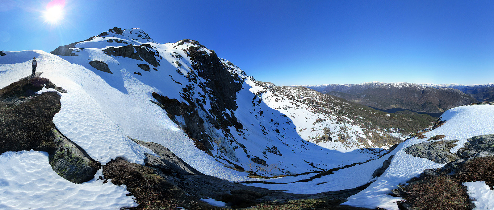
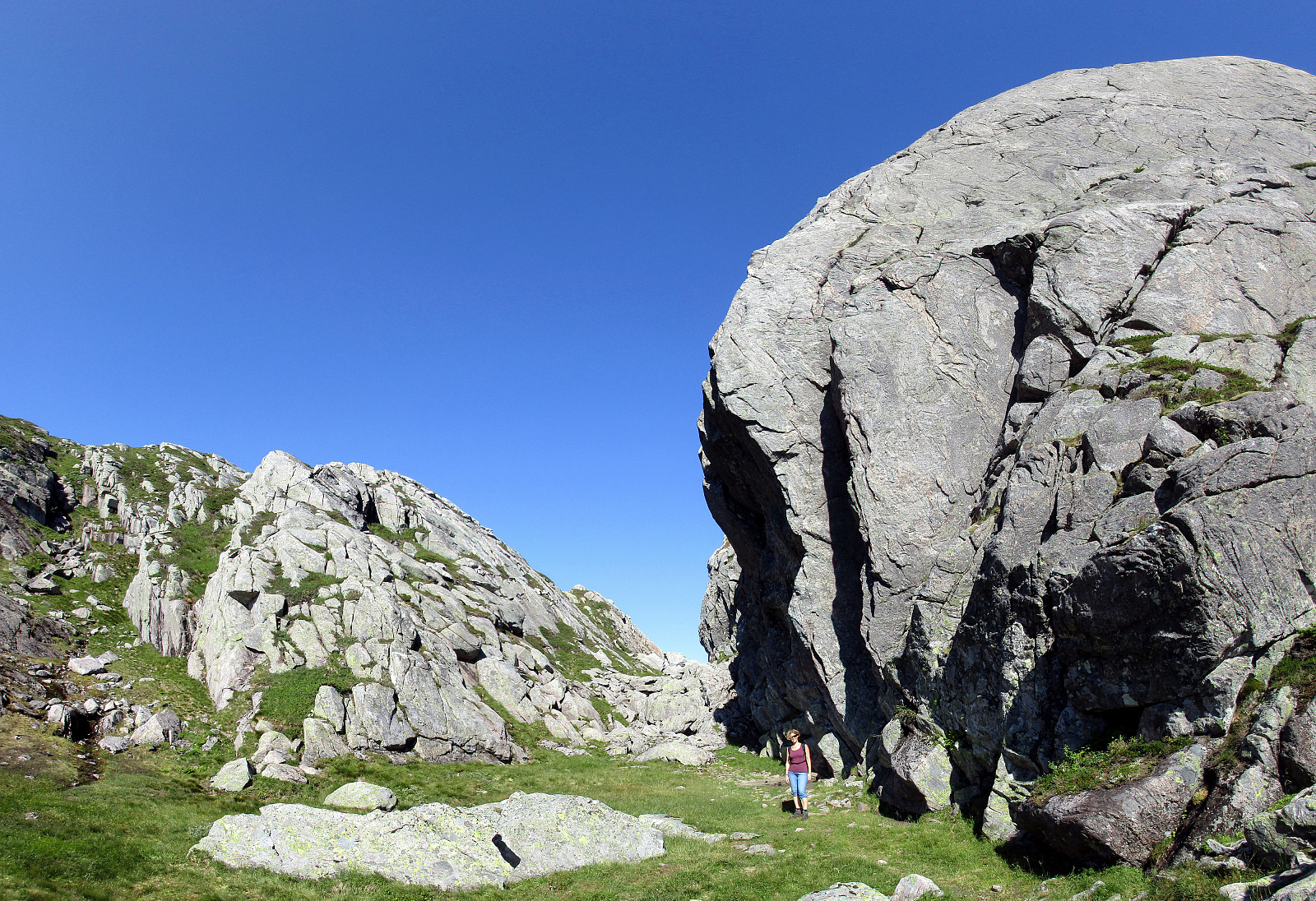
Geitanipa
- Dato:
- 08.07.2017
- Turtype:
- Fjelltur
- Turlengde:
- 2:00t
- Distanse:
- 4,8km
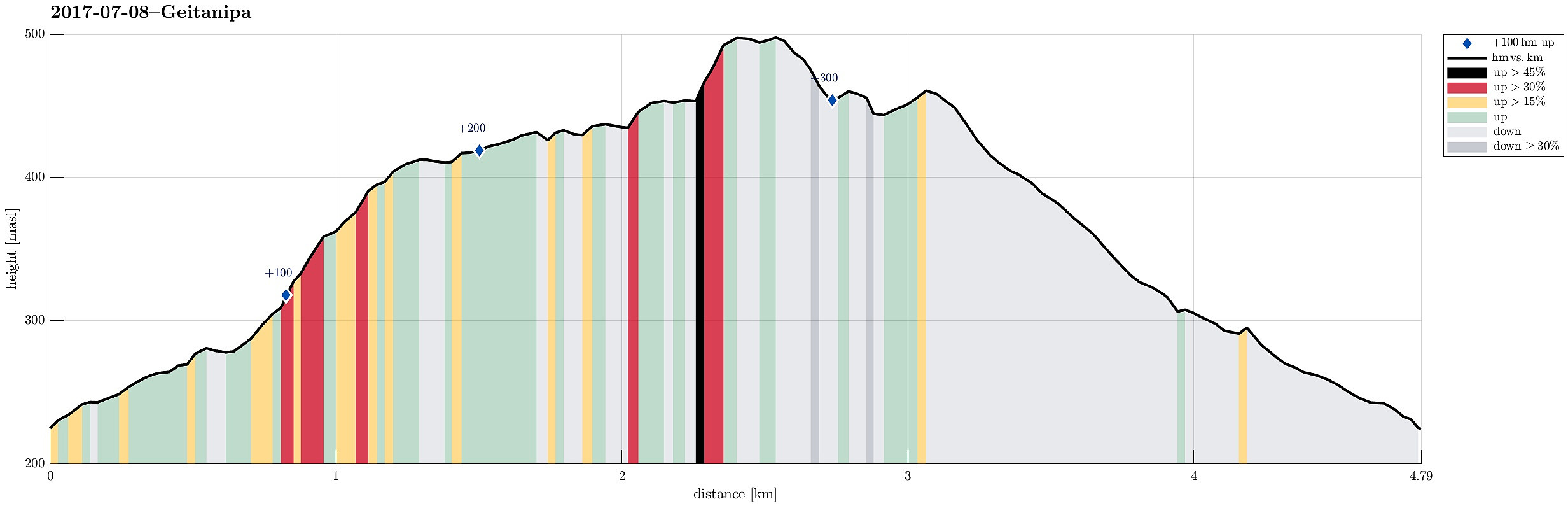 We started from Langhelle, between Trengereid and Vaksdal, at the end of the paved (small and narrow) road, which winds up there from E16 near the fjord. We first walked up a little longer along the gravel road until the point, where it makes a sharp turn right, leading further up to Seterkokane. We then followed a forest trail that brought us further up (in southeastern direction) to the saddle between Trollaberget and Geitanipa. At about this saddle, we decided to not descend to the southern side, but instead to connect to Geitanipa, instead. While there was not really any path or trail to Geitanipa, we still managed to get there without major difficulties (Geitanipa is, in fact, a bit steep on its eastern side, so it is necessary to carefully choose a good spot for ascending to it). >>>
Flatafjellet from Helle
- Dato:
- 17.09.2016
- Turtype:
- Fjelltur
- Turlengde:
- 5:45t
- Distanse:
- 16,7km
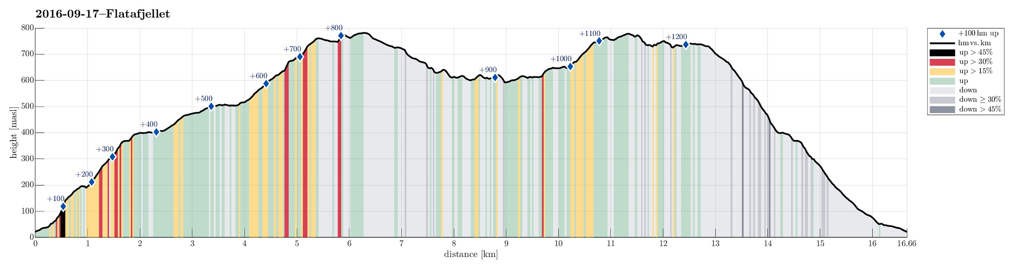 We took the E16 from Bergen towards Voss. Shortly after passing by Stanghelle, right after driving through Helletunnelen (and before entering Dalevågtunnelen), we left E16 to the left and continued on Sætravegen (for only few meters), which first goes parallel to E16, but then over it (over the tunnel-entry to Dalevågtunnelen) and to the other side. Driving Sætravegen up a little (to the to or three houses, there), we learned that it was not appreciated that we would park anywhere there---instead, we found a very good parking spot right next to E16 (but on its southeastern side). From there, we started walking, first Sætravegen up. At the upper end of the few houses, a trail leaves to the left. We took this trail, which leads one quickly upwards and into Espeligjelet (one could also >>>
Høgafjellet
- Dato:
- 21.08.2016
- Turtype:
- Fjelltur
- Turlengde:
- 5:45t
- Distanse:
- 15,2km
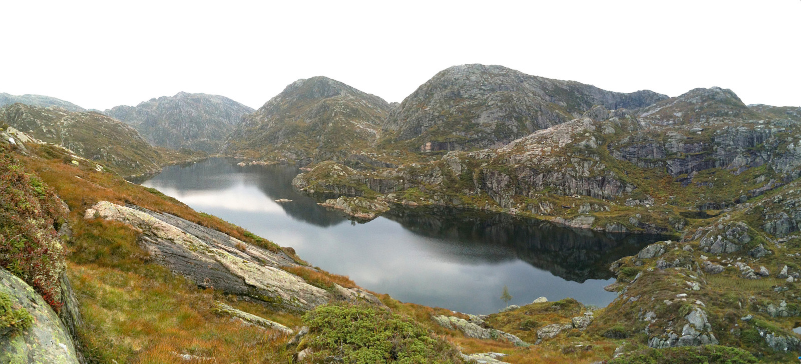
 We took the car to Osterøy and there to Tysso, where we followed a narrow road up to Osvatnet, parking at the end of this road, right next to the power station house. We knew already that the old route via the many wooden stairs right next to the water pipe that leads down to the power station house was closed and we followed the alternative route, which first leads into the valley of Kupelva, right underneath Preikestolen. All the efforts that were made to make this track welcoming and easy to go are highly appreciated! Near some moor, right underneath Preikestolen, the path splits and the ones, who wish to ascend towards Høgafjellet, take the path to the right, turning southwards. Via some stairs that help through a small, narrow valley, one gets up to the level of Nedra Botnavatnet. >>>
Kvigedalsegga
- Dato:
- 23.08.2015
- Turtype:
- Fjelltur
- Turlengde:
- 4:30t
- Distanse:
- 8,3km
 Taking E16 from Bergen into the direction of Voss, we passed by Dale and turned left in Dalseid, shortly after. We then came through five very short tunnels along the fjord, before parking next to the road, right before Tretteneset. From there, we first walked up a forest road, which quickly ascends through Dalseidmarkåna. At about 260 masl, the forest road turns left and connects to Sæterdalen, while we continued in Dalseidmarkåna, right underneath the steep and high northern cliffs of Stølsberget (while it is easy to see, where to leave the forest road, it isn't 100% easy to then find the path further upwards -- keeping as close to the cliffs and as high above the stream as possible, on the southern side of it, seems to be a good rule to find the simple path, though). At about 400 >>>
Hananipa
- Dato:
- 18.05.2014
- Turtype:
- Fjelltur
- Turlengde:
- 4:00t
- Distanse:
- 11,2km
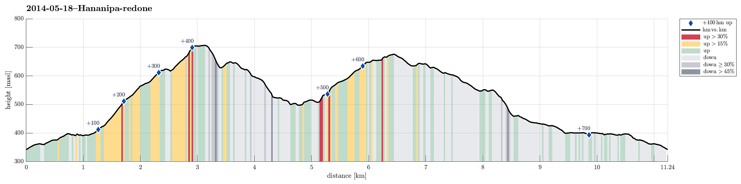 Hananipa from Skulestad (and back via Trollabotshaugen) was a nice round tour in beautiful landscape and with fantastic views over the fjord!
Web page WestCoastPeaks.com provides useful information about Hananipa, Raudnipa, Krånipa, and Raudfjell
and also Petter Bjørstad has a useful page about Hananipa .
Web page UT.no from the Norwegian Trekking Association recommends this hike up and down Hananipa (only part of our hike, though).
Hananipa from Skulestad (and back via Trollabotshaugen) was a nice round tour in beautiful landscape and with fantastic views over the fjord!
Web page WestCoastPeaks.com provides useful information about Hananipa, Raudnipa, Krånipa, and Raudfjell
and also Petter Bjørstad has a useful page about Hananipa .
Web page UT.no from the Norwegian Trekking Association recommends this hike up and down Hananipa (only part of our hike, though).
Hestafjellet
- Dato:
- 07.09.2013
- Turtype:
- Fjelltur
- Turlengde:
- 4:00t
- Distanse:
- 9,0km
 Quite a rough tour from Dalegarden (up along Brattreimelva and down to Helletræer) -- more demanding than expected, mostly because there wasn't any path when crossing the mountain.
Selected photos are available as Google photo album .
Web page WestCoastPeaks.com provides useful information about Høgenipa, Knutstignovi, Hestafjellet, Kvigedalseggi, Slåttenovi, Harafjellet, and Nipa .
Quite a rough tour from Dalegarden (up along Brattreimelva and down to Helletræer) -- more demanding than expected, mostly because there wasn't any path when crossing the mountain.
Selected photos are available as Google photo album .
Web page WestCoastPeaks.com provides useful information about Høgenipa, Knutstignovi, Hestafjellet, Kvigedalseggi, Slåttenovi, Harafjellet, and Nipa .
