Arkiv - dato
Arkiv - aktivitet
-
Annen tur (1)
- Kajakkpadling (1)
-
Annen vintertur (4)
- Trugetur (4)
- Fottur (740)
-
Skitur (4)
- Fjellskitur (4)
-
Sykkeltur (137)
- Blandet sykling (51)
- Gatesykling (9)
Arkiv - Etter geografi
"Peakbookvenner"


Lister jeg samler etter
-
Bergen ≥ 50m pf. og ≥ 100 m.o.h.
(87/89)
 97%
97% -
Most dominating tops of the Bergen peninsula
(68/75)
90%
-
Utvalgte topper og turmål i Bergen
(316/350)
90%
-
Alle topper i Bergen
(357/398)
89%
-
Opptur Bergen
(100/113)
88%
-
De syv fjell rundt Bergen
(6/7)
85%
-
Sund ≥ 50m pf.
(14/18)
77%
-
Os ≥ 50m pf.
(25/34)
73%
-
Søyler (fastmerker) i Bergen
(68/100)
68%
-
Fjell ≥ 50m pf.
(21/32)
65%

Round around Ono
- Dato:
- 04.06.2023
- Turtype:
- Fottur
- Turlengde:
- 3:00t
- Distanse:
- 9,3km
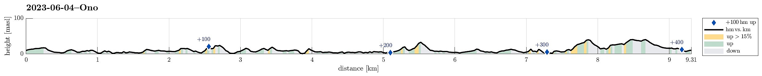 While checking for new places in Øygarden that we had not visited so far, we found Ono and decided to make a hike there. After driving first westwards out of Bergen (towards Sotra), we then turned right (in northern direction) near Kolltveit, following then road #561. At Rong, we then turned left (westwards, again) in order to get over to Ono (passing the school of Rong along Svartevikvegen). After crossing two small bridges, we had arrived at Ono. There, we parked "at once" next to the road Onevegen. The southern part of Ono is well marked for hikers -- especially those, who wish to visit Dethloffhytta in the southwest of Ono. We followed first this main trail (in southwestern direction) until we crossed over the inner end of Stekkane. On the other, southern side, we then >>>
Førdesveten from Vorland
- Dato:
- 18.03.2023
- Turtype:
- Fottur
- Turlengde:
- 4:00t
- Distanse:
- 11,0km
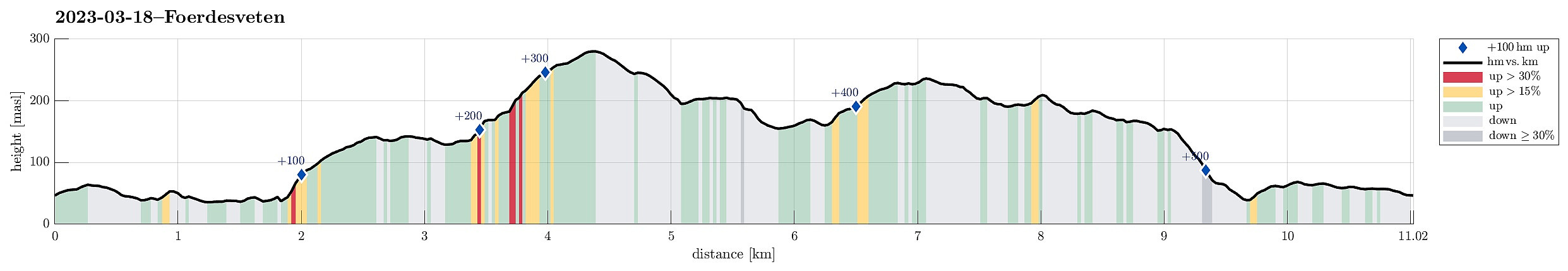 We decided to hike Førdesveten in the south of Sotra and planned for an approach from the northwest (from Vorland). After driving south from Fjell, we parked along Sundvegen, where one also finds the head of a trail that leads through Grøndalen into the direction of Vorlandsvatnet. Using this trail, we approached Vorlandsvatnet at Vassvika from the northwest, following a trail that passes by Vorlandsvatnet in its northeast. This is a nice and convenient trail that leads all the way to the southern-most point of Vorlandsvatnet. There, one could "back out", again, following a gravel road towards the west. Instead, we entered the little valley that comes down there from the south (mostly). After only about 100m into this valley, we ascended (kind of steeply) to the southeast, >>>
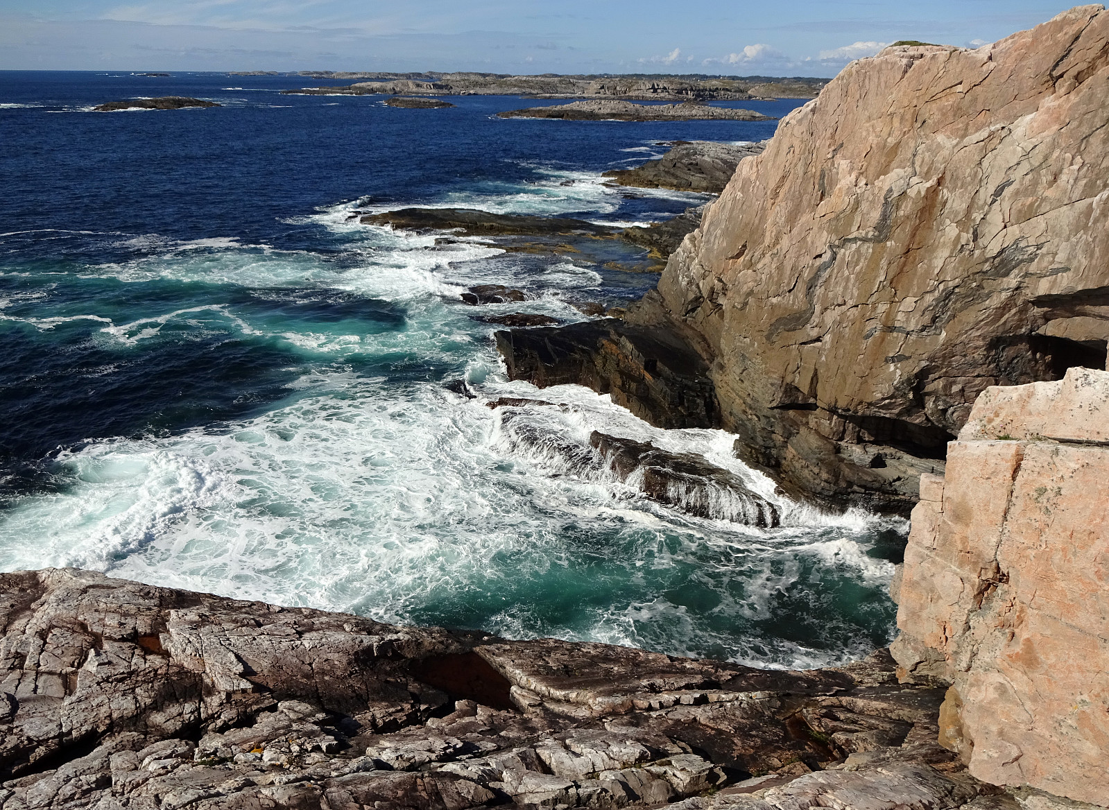
Barmaneset on Algrøyna
- Dato:
- 13.08.2022
- Turtype:
- Fottur
- Turlengde:
- 3:00t
- Distanse:
- 6,8km
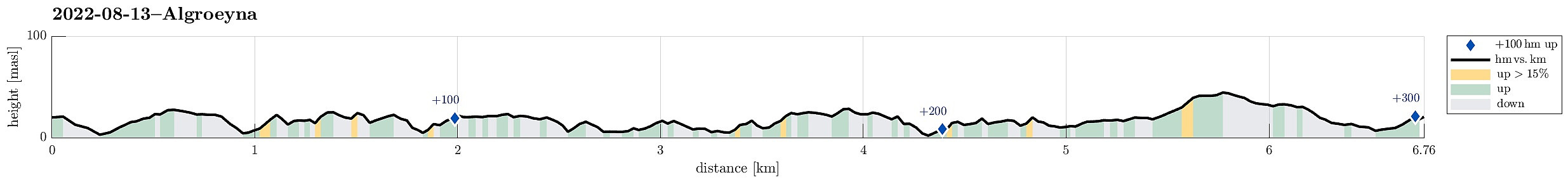 A nice summer day invited us to redo one of our well liked hikes on Algrøyna: to Barmaneset and back. Parking in the east of the little village on Algrøyna, along Nordre Øyavegen, we first followed the street a little further, before turning to the left and onto Kongvikvegen. Once passed Jonsokhaugen, we left the road, rounding a farm house on the way down to the innermost end of Kungvika. There, we "crossed over" to the southern side in order to end up on Barmaneset, not on Smalaneset, north of Barmaneset. Walking out to Barmaneset is then easy, following a proper trail. Once at the western end of the trail, we continued a bit further out towards Langtrotten, which always impresses with its wild nature. On the way back, we then followed "the other trail", a little >>>
Nice summer evening on Skogsøyna
- Dato:
- 01.08.2022
- Turtype:
- Fottur
- Turlengde:
- 3:00t
- Distanse:
- 5,9km
 With the prediction of another nice summer day, we headed for Skogsøyna in Øygarden. After driving to Sotra in the west of Bergen, we turn northwards at the roundabout south of Kolltveit and followed road 561 all the way northwards until we turned left (in westward direction) on Ona, then following the minor road 5276 until we crossed the bridge to Skogsøyna. Since all parking places were taken near the trail head, we continued a few meters to Langholmen and parked there next to the road. We then walked the few meters back across the bridge over Langholmsundet to get to the trail head. Following the marked trail out to Skogsøytua is by now really easy (most of the previously wet areas have been covered so that it's now just a nice walk until one gets to the "high point" (at >>>
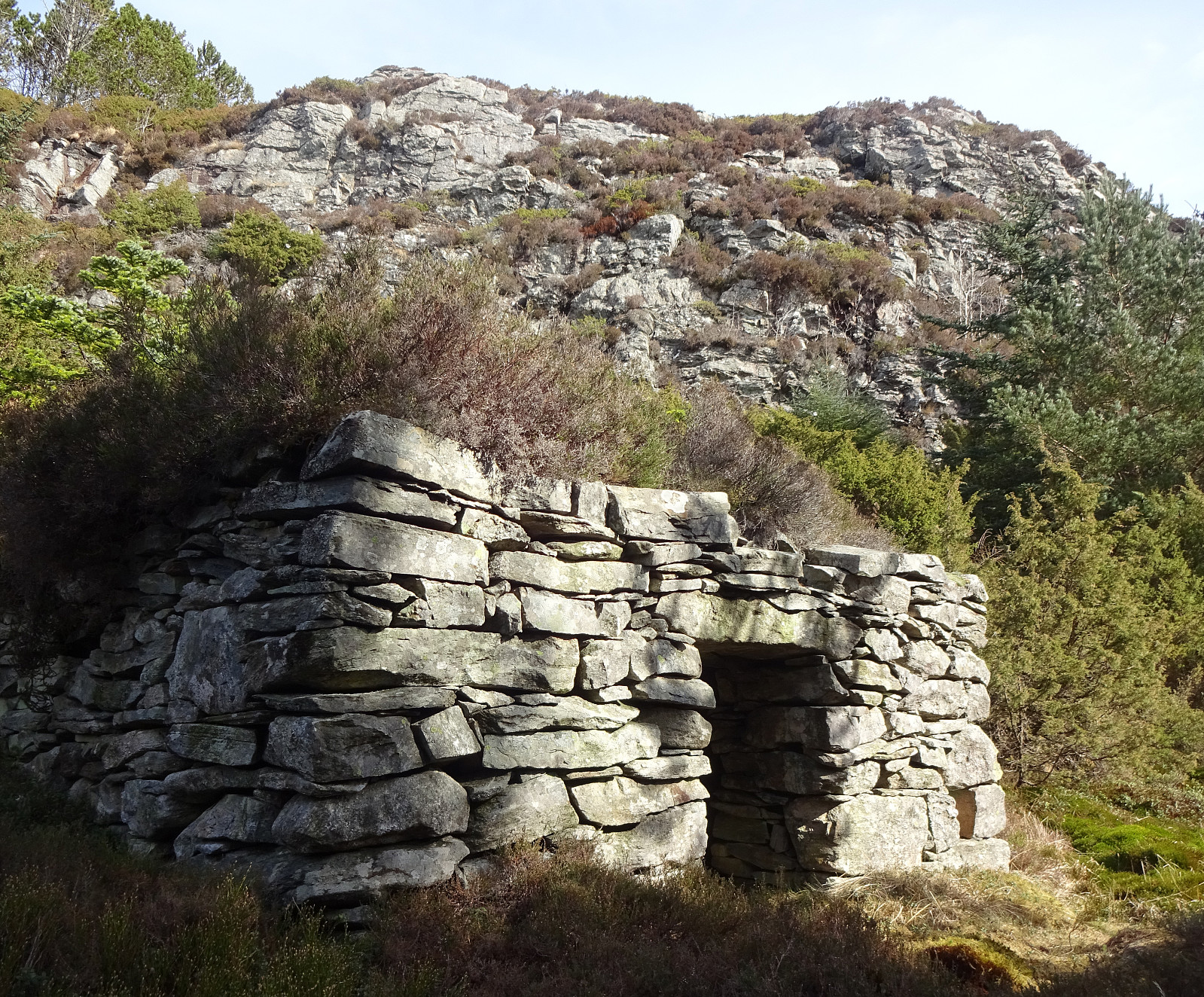
Liatårnet and Haganesfjellet from Liaskjeret
- Dato:
- 23.04.2022
- Turtype:
- Fottur
- Turlengde:
- 3:30t
- Distanse:
- 8,8km
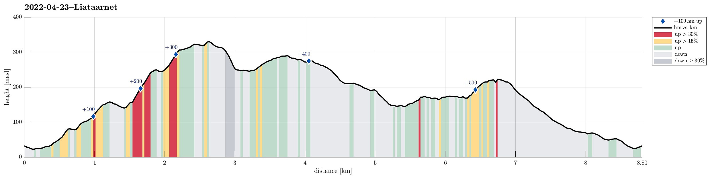 Liatårnet and Haganesfjellet from Liaskjeret. We parked next to Liaskjershallen in the southeast of Liatårnet on Sotra and walked first back (northwards) along Liaskjervegen until we found the spot where one can ascend to Dansarhaugen (just a few steps above the last houses on the hillside up to Liatårnet). We then crossed Skoradalen, mostly in northern direction, before we changed course after crossing over Bukkhelleren into a more northwestern direction, ascending rather straight up towards Liatårnet. Once on Liatårnet, we started our traverse across the heights south of Liatårnet, mostly in southern direction. South of Høgafjellet, we then came to Kattatjørna. This time, we passed by this lake on its eastern side, also stepping over Kattafjellet. It then was just straight southwards, >>>
Purkeneset from Eide
- Dato:
- 02.04.2022
- Turtype:
- Spasertur
- Turlengde:
- 2:30t
- Distanse:
- 7,6km
 On a day with mixed weather, we made a short hike to Purkeneset north of Eide on Sotra. We parked near the road and crossed first Varden and Kyrkjehaugen before connecting to the trail that leads out to Purkeneset. From the top of Purkeneset we enjoyed some nice view across Kørelen, i.e., the rather big lake in the west of Hammarsland. After walking back along the same trail, we included a short excursion to Hopen in the north of Spilda. From there, we just walked back to Eide and called it a day.
Selected photos are available as Google photo album .
See also the related FB-page Hiking around Bergen, Norway .
Web page UT.no from the Norwegian Trekking Association recommends another hike to Purkaneset .
On a day with mixed weather, we made a short hike to Purkeneset north of Eide on Sotra. We parked near the road and crossed first Varden and Kyrkjehaugen before connecting to the trail that leads out to Purkeneset. From the top of Purkeneset we enjoyed some nice view across Kørelen, i.e., the rather big lake in the west of Hammarsland. After walking back along the same trail, we included a short excursion to Hopen in the north of Spilda. From there, we just walked back to Eide and called it a day.
Selected photos are available as Google photo album .
See also the related FB-page Hiking around Bergen, Norway .
Web page UT.no from the Norwegian Trekking Association recommends another hike to Purkaneset .
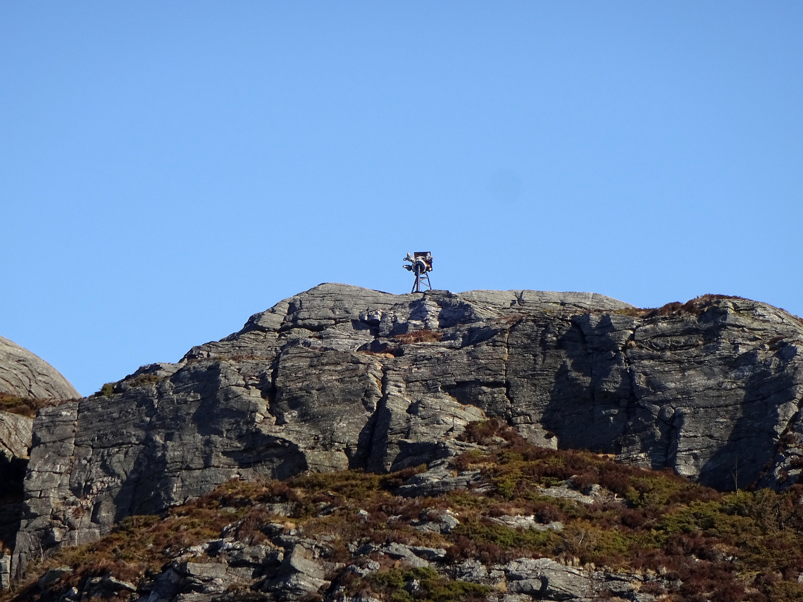
Høgafjellet and Haganesfjellet from Buabrekko
- Dato:
- 26.03.2022
- Turtype:
- Fottur
- Turlengde:
- 3:00t
- Distanse:
- 8,6km
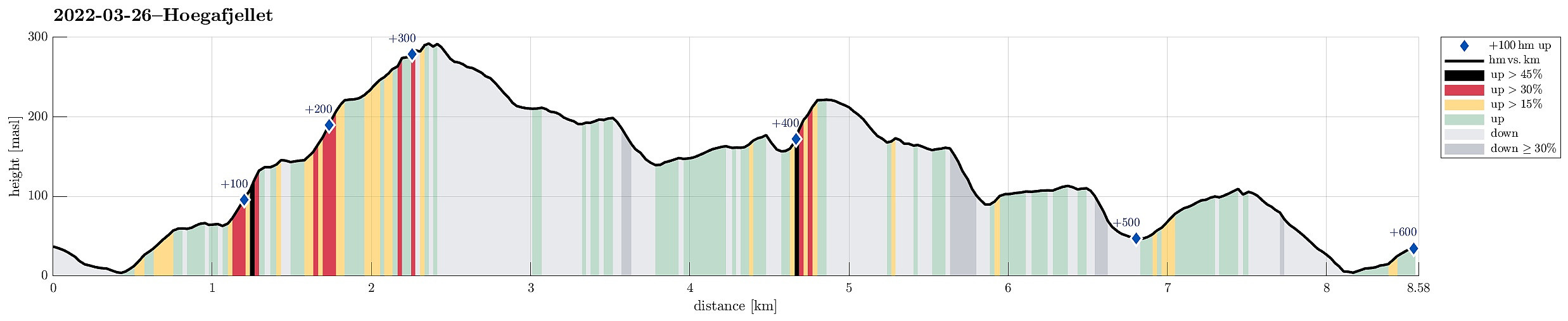 Høgafjellet and Haganesfjellet from Buabrekko. We parked near Tellnesvegen and walked down Buabrekko, crossing over the stream down from Kvernavatnet where it enters Pollen at its very northern end. On the other, eastern side, a trail leads up to the northern end of Ravnafjellet. Originally, we had planned to find a minor trail that should have forked off somewhere half way up in northeastern direction. Since we had not found this trail, we quickly found ourselves at the northern end of Ravnafjellet. There, we left the trail and continued through some relatively wet terrain northwards. Basically right west of Varden, we then found a good spot for ascending to the "next level", north of Vedatåna. There, we then also connected to a trail that circles Varden in its west. After >>>
Førdesveten from Kleppe
- Dato:
- 20.03.2022
- Turtype:
- Fottur
- Turlengde:
- 3:00t
- Distanse:
- 8,4km
 Hike to Førdesveten from Kleppe. We parked near Bjøllhaugen in the east of Kleppe and walked along the road towards Kleppe first. We then turned onto Kleppakslavegen into a northern direction, starting out ascent to Kleppaksla there. A proper trail leads all the way up, just east of Fenadalen. From Kleppaksla we then followed its northern ridge to Ramnaberget, offering some nice views into Kleppadalen in the west and across Trollavatnet in the north east. After passing by Trollavatnet, we crossed the trail leading to Veten from Kleppadalen and ascended to Storevarden in the west of Vetadalen. From there, then without a trail, we continued further north to Middagsberget. Even though Førdesveten has a prominent cliff on its western side, we still had planned to ascend to Veten from >>>
Liatårnet from Li
- Dato:
- 11.12.2021
- Turtype:
- Fottur
- Turlengde:
- 2:30t
- Distanse:
- 5,3km
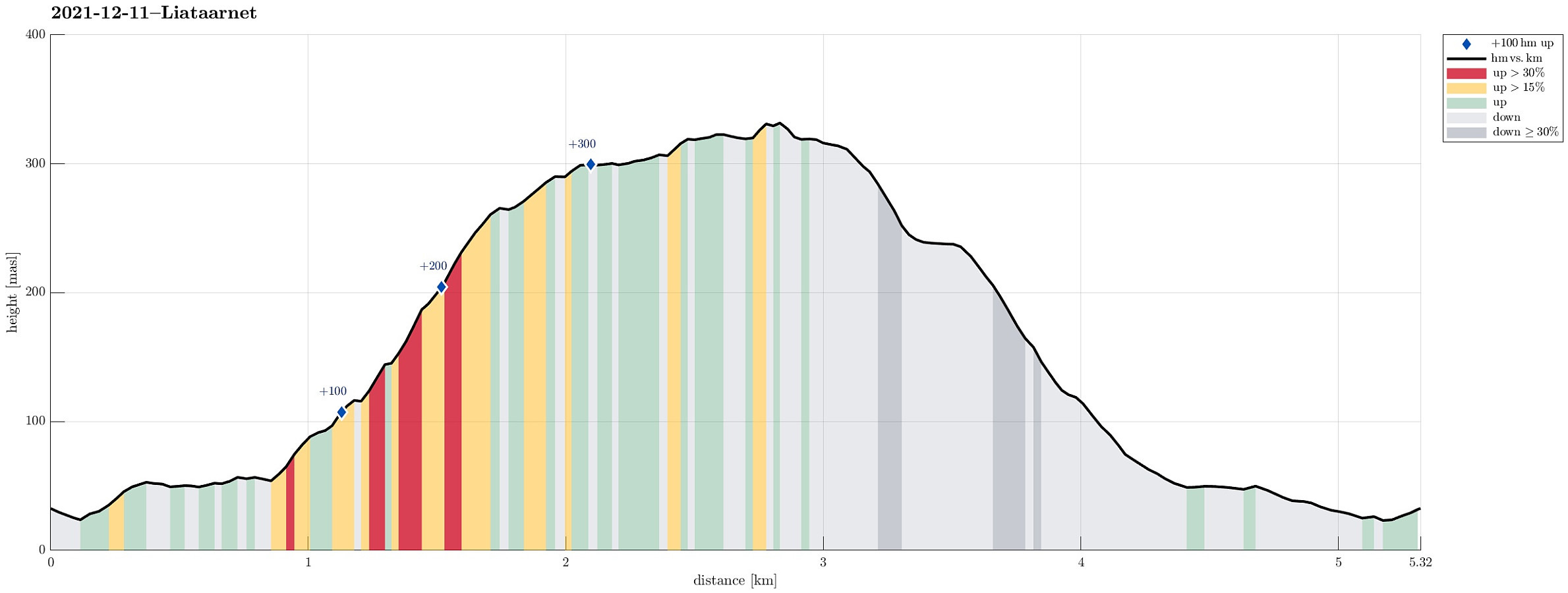 We expected some sunshine (not any long day, though, of course) and thus headed for some snow near Bergen! :-) Remembering a very nice winter hike up to Liatårnet in Jan. 2019 , we aimed at Liatårnet, again, but this time via a slightly different route. Also this time, we drove to Li (on the eastside of Liatårnet) and parked near Liaskjærshallen right next to Liaskjervegen at Liaskjeret. From there, we first walked back a little (north along Liaskjervegen) until we turned left (onto Elvabakkvegen). After walking up this road for a few meters, the road splits into two in a T-junction; there, straight onwards, one finds a trail head from which one can get behind the houses in westwards direction (for ex., towards Trollhaugen in the southwest). Our plan was to ascend into the direction of Liatårnet from there, so we did not >>>
Exploring Knappen near Kallestad
- Dato:
- 04.07.2021
- Turtype:
- Fjelltur
- Turlengde:
- 4:00t
- Distanse:
- 6,7km
 The plan was to use a nice, warm summer day and hike into the north of Kallestad. We parked next to Grendahuset in Kallestad and first walked the street back northwards until we came to Sjoartjørna. Where Kallestadvikvegen turns around this little lake (in its west), a trail heads off in northwestern direction. After only a few meters, already, one has the choice between going directly to Storhaugen, or ascending to Austre Storhaugen, first. We did the latter, heading up to Austre Storhaugen, first, enjoying some nice views, including one back down to Sjoartjørna. From Austre Storhaugen, one can then connect to Storhaugen via a steep descent, first, and then joining the trail that comes around Austre Storhaugen in its south. From Vestre Storhaugen, just a few meters in the west of Storhaugen, >>>
