Arkiv - dato
Arkiv - aktivitet
-
Annen tur (1)
- Kajakkpadling (1)
-
Annen vintertur (4)
- Trugetur (4)
- Fottur (740)
-
Skitur (4)
- Fjellskitur (4)
-
Sykkeltur (137)
- Blandet sykling (51)
- Gatesykling (9)
Arkiv - Etter geografi
"Peakbookvenner"


Lister jeg samler etter
-
Bergen ≥ 50m pf. og ≥ 100 m.o.h.
(87/89)
 97%
97% -
Most dominating tops of the Bergen peninsula
(68/75)
90%
-
Utvalgte topper og turmål i Bergen
(316/350)
90%
-
Alle topper i Bergen
(357/398)
89%
-
Opptur Bergen
(100/113)
88%
-
De syv fjell rundt Bergen
(6/7)
85%
-
Sund ≥ 50m pf.
(14/18)
77%
-
Os ≥ 50m pf.
(25/34)
73%
-
Søyler (fastmerker) i Bergen
(68/100)
68%
-
Fjell ≥ 50m pf.
(21/32)
65%

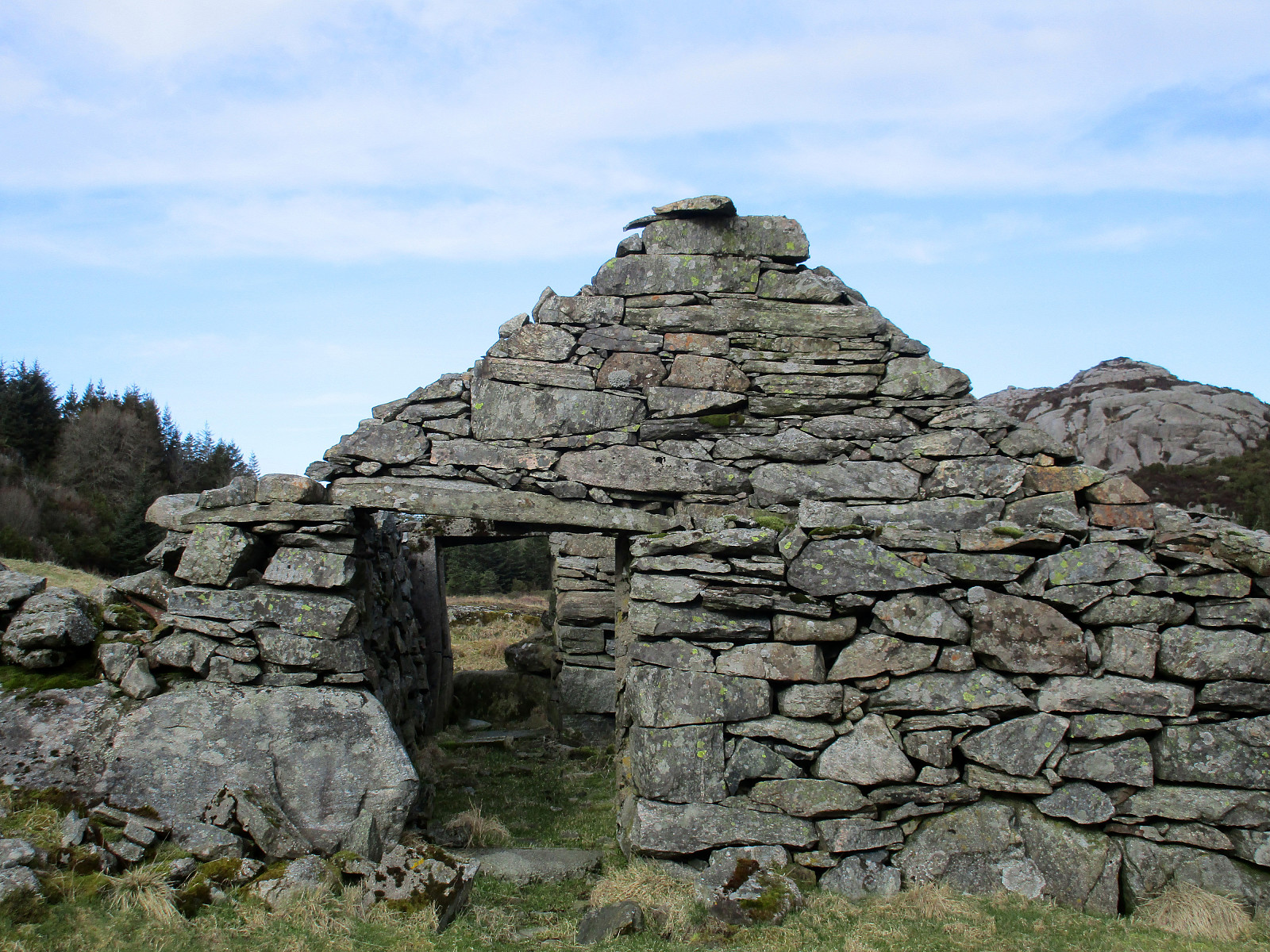
Wild Golta
- Dato:
- 13.04.2020
- Turtype:
- Fjelltur
- Turlengde:
- 3:00t
- Distanse:
- 5,1km
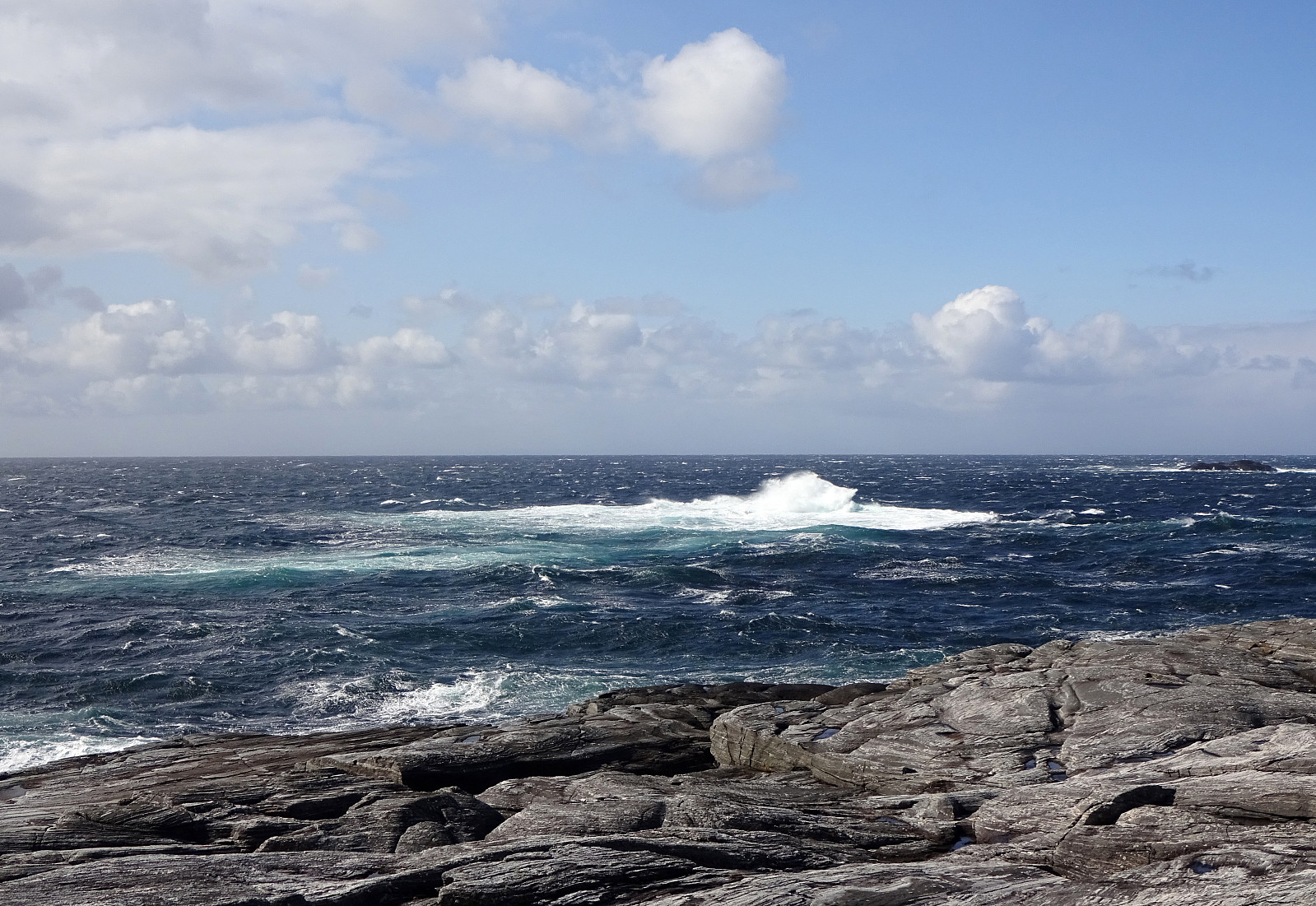 The weather forecast was "interesting": 3 or 4 degrees Celsius and strong winds from the north (with gale warnings nearby). Sounds like a nice day for another trip to the outer islands! :-) This time, we chose Golta (south of Telavåg and west of Glesvær), which is wild and nice! We parked at the parking lot near the inner end of Vogga and started our short hike from there. The route is trivial to find and also not very long. Within a few minutes one gets out to the wild rocks near the North Atlantic. And clearly we weren't disappointed (again): very impressive, when the wind works the sea so hard! We walked for a longer while around the rocks and enjoyed the atmosphere, rounding Lutavika and then also Midtvika, before heading back. Even though a shorter trip, it's definitely >>>
Sælskletten and Sælsfjellet on Tofterøy
- Dato:
- 28.03.2020
- Turtype:
- Fjelltur
- Turlengde:
- 2:00t
- Distanse:
- 6,5km
 Another Saturday with a promise of cold but nice weather invited us to plan another hike near the North Atlantic, making this the third in a row, after our nice hike to Brotavarden from Telavåg and our excursion to Ternneset from Kausland . This time, our goal was to hike a little round on Tofterøy, far in the southwest of Sotra. After following road 555 southwards, we turned right (onto road 200 towards Tofterøy) and passed over the narrow bridge (Tofterøybrua), after first havig waited for two horses to finish their (partially stressed) passage over the bridge. :-) On Tofterøy, we then followed the road until we came close to Trælevika. There, just north of Storavatnet, we parked and started our hike. The first goal of our hike was Sælskletten in the southeast of where we had parked. In order to find the needed trailhead, we had to walk back along >>>
Ternneset from Kausland
- Dato:
- 21.03.2020
- Turtype:
- Fjelltur
- Turlengde:
- 3:15t
- Distanse:
- 11,8km
 Once again, we aimed at using a nice weekend day for getting some fresh air. Since we will had fond memories of our recent hike to Brotavarden from Telavåg , we decided to once again aim for the outer islands. This time, we planned for a hike from Kausland, just a bit north of Glesvær. The idea was to connect to Goltasundet (from the east) and then hike out towards the North Altantic along it's northern shore. On Sotra, we headed towards Glesvær. Near Kausland, we then left Glesnesvegen to the right (west), before parking only a few hundreds of meters down this little side road. From there, we followed a very clear trail (more like a gravel road in the beginning), leading us westwards. Soon after, we approached Goltatjørna from its north. We first tried to round it on a "tight route", but soon understood >>>
Brotavarden from Telavåg
- Dato:
- 14.03.2020
- Turtype:
- Fjelltur
- Turlengde:
- 3:30t
- Distanse:
- 11,8km
 We really needed some fresh air (these times, you know) and since we were not really prepared for lots of snow and so, we decided to give the outer islands another try. After some consideration, Brotavarden was chosen as the hiking goal (with a start-point near Telavåg). We parked a few hundreds of meters before coming to Telavåg, near some soccer fields in the southeast of Telavåg. Just on the other side, we located the trail head and headed at once for our first intermediate goal, Nipa (in the east of Telavåg). Even though it's only a few meters up to the "top" of this cliff, one still has some nice views from there! Since winds were strong and temperatures were rather low, we did not stay there for any longer time, but continued (into the direction Brotavarden) immediately. >>>
Short round on Bjorøyna
- Dato:
- 31.12.2019
- Turtype:
- Fjelltur
- Turlengde:
- 1:30t
- Distanse:
- 3,1km
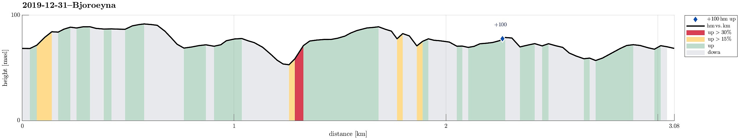 We took the car to the west of Bergen and from Loddefjord along Hillerenveien to get to the undersea tunnel, which connects to Bjorøyna. There, we continued along the "main road" across Bjorøyna (Fv207) until we parked next to the school of Bjorøy. From there, we first ascended to Rundelen across its northern ridge, Bjorøyna's highest hill, right in the east of the school. Once up there -- it's only a few meters above the school --, we continued in southern direction across the north-south going heights. Before eventually turning westwards, we first included a smaller hill in the southeast of the heights of Rundelen. From there, we then descended in western direction (northwest of Stokkhaugen) until we crossed some minor swamp to get over to another hill on the other (western) >>>
Skogsøyna on a nice summer Sunday!
- Dato:
- 14.07.2019
- Turtype:
- Fottur
- Turlengde:
- 3:00t
- Distanse:
- 5,5km
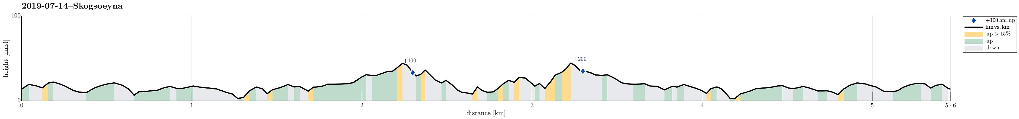 Since we were in Øygarden already, we decided to also pay a visit to Skogsøyna, which always is worth a little hike! To get there, we found road 228 towards Herdleværet. On Skogsøyna, just before crossing the bridge to Herdleværet, we parked the car and started to hike towards the west, following the northern rim of Skogsøyna. We were again positively impressed about work that was done recently to further improve this trail, making it easier to avoid wet and/or muddy shoes. Nice! :-) At the outer tip of Skogsøyna, we reached our goal for this day, Skoysøytua (some 50m above sea level and with nice views over the open Atlantic!). We explored the cliffs and watched the energetic ocean rumble against the rocks of Skogsøytua. We also rounded the cliffs in order to get further down >>>
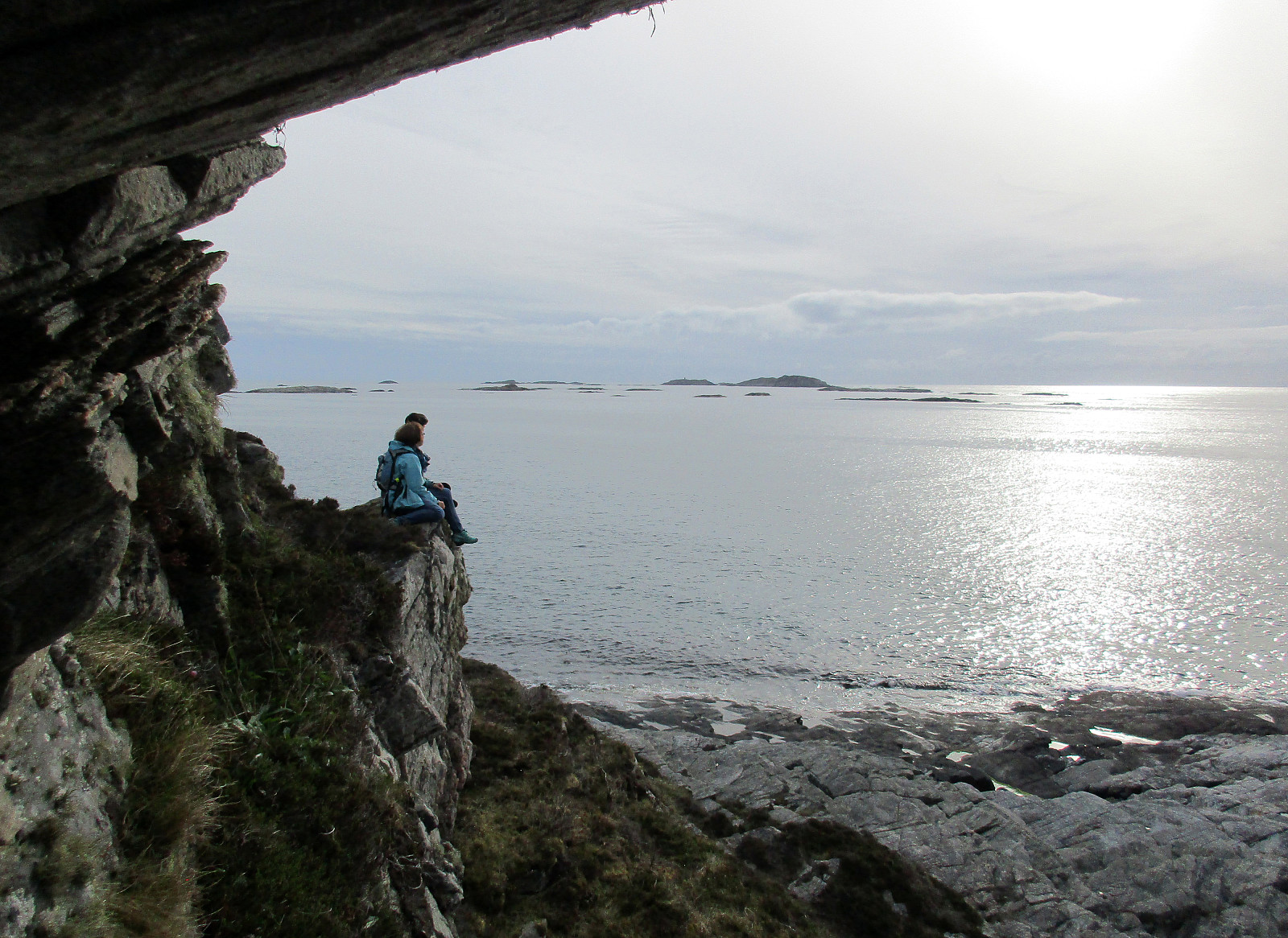
Gløvrebu in Øygarden
- Dato:
- 14.07.2019
- Turtype:
- Fottur
- Turlengde:
- 1:30t
- Distanse:
- 2,6km
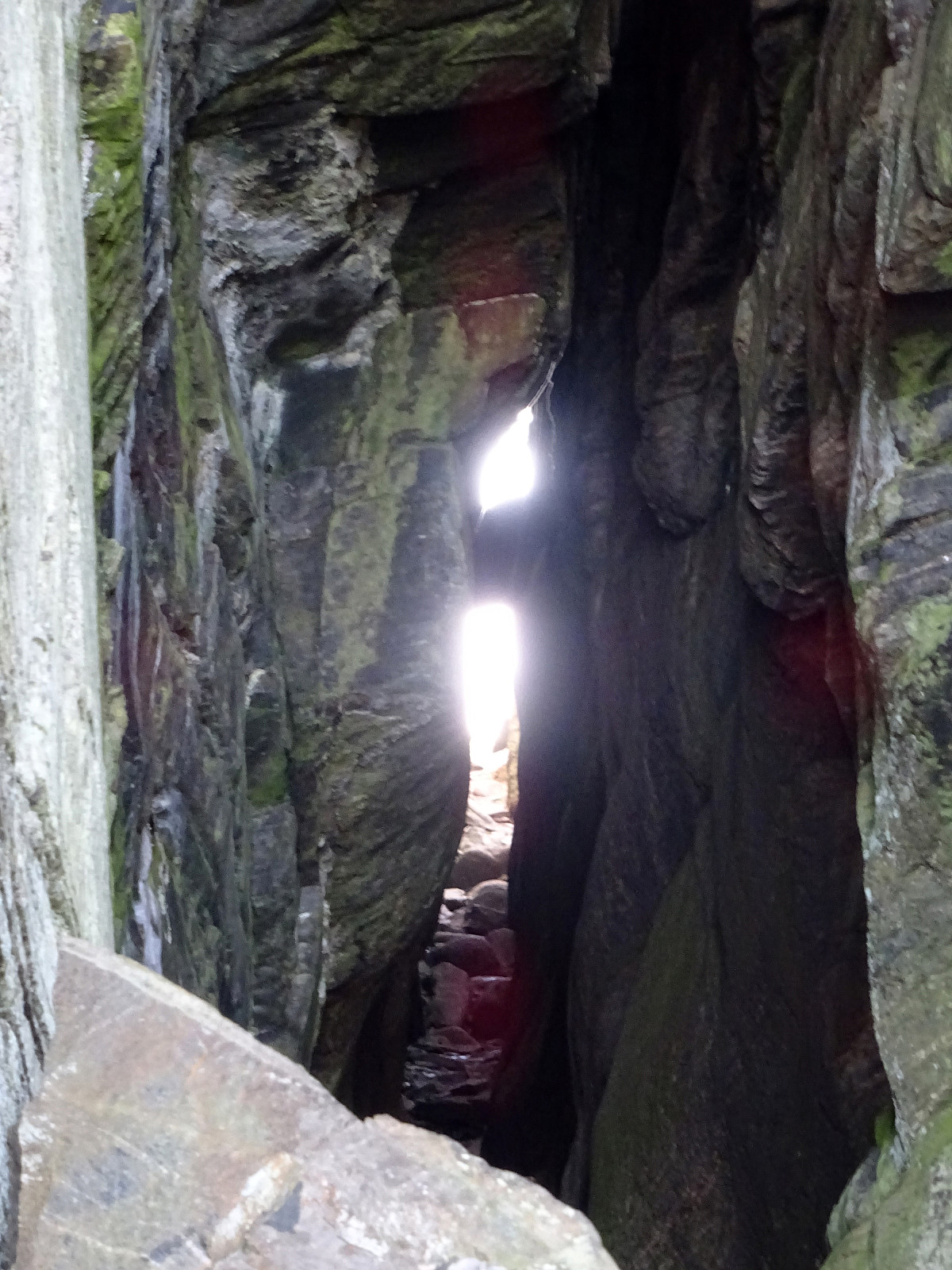 Driving from Bergen to Sotra, we turned north after Kolltveittunnelen, continuing on road 561 towards Øygarden. Driving almost all the way out (to Hellesøy), we came to Seløyna. While the road is getting really narrow there, one cannot overlook Hjelme Kyrkje, when passing by. Only meters later, right next to the rather big graveyard, we parked the car and started to follow a nice trail into the direction of Stakksvika. Close to the sea, the trail splits with the southern route being a bit more direct to Gløvrebu. Still, the slightly longer route (towards Stakksvika first) is very nice, offering views to and beyond Bobbeskjeret. From there, it's then towards the south and to Gløvrebu. While the whole area there is nice to see, the main sight is a major cut through the rock near the >>>
Gløvrebu (Øygarden)
- Dato:
- 31.05.2019
- Turtype:
- Spasertur
- Turlengde:
- 1:30t
- Distanse:
- 3,0km
 We thought about paying the open sea a visit, this evening. Leaving Bergen towards Sotra, we turned north right after Kolltveittunnelen, continuing on road 561 towards Øygarden. Driving almost all the way out (to Hellesøy), we came to Seløyna. While the road is getting really narrow there, one cannot overlook Hjelme Kyrkje, when passing by. Only meters later, right next to the rather big graveyard, we parked the car and started to follow a nice trail into the direction of Stakksvika. Close to the sea, the trail splits with the southern route being a bit more direct to Gløvrebu. Still, the slightly longer route (towards Stakksvika first) is very nice, offering views to and beyond Bobbeskjeret. From there, it's then towards the south and to Gløvrebu. While the whole area there is >>>
Via Storaskjenet to Sangoltshornet
- Dato:
- 17.03.2019
- Turtype:
- Fjelltur
- Turlengde:
- 4:15t
- Distanse:
- 12,7km
 I took the car to Sotra and there to Sund kommune (on road 555 first). Near Hammarsland, I turned left (towards Klokkarvik), following road 198 for a bit. Near the northern-most point of Dommedalsvatnet, I parked and started my hike from there. I first headed towards Ormadalen and up through it (mostly without any trail). A little higher up there, I then connected to the main path towards Storaskjenet. Shortly later, I found myself on Storaskjenet: a substantial cliff (towards the west). After enjoying the views from there (and taking some photos), I continued in southern direction along the ridge. The path, which the map shows, is not easy to find and I ended up improvising most of the "way" along this ridge (no problem). Near Tveitahøgda, I reconnected to the path, which >>>
Brotavarden from Kallestad
- Dato:
- 10.03.2019
- Turtype:
- Fjelltur
- Turlengde:
- 2:45t
- Distanse:
- 7,7km
 I took the car to Sotra and there to Kallestad, leaving the road 555 at Trengereid. Right next to Sjoartjørna, I found the sharp turn to the left (and up to Kallestad), even though there wasn't really a street sign to see. I then parked next to Kallestad Grendahus and started my hike from there (first still on the road in western direction and between some houses). Soon, I left Kallestad behind and began my hike through wild Sotra. :-) When crossing over a meadow (south of Stølstjørna, still very near to Kallestad), I failed to see, where the trail continued (a bit further north of where I went). So, instead of hiking along the trail, I ended up on Skjenhaugen, enjoying the view from up there! I then continued (parallel to the trail) further in western direction (towards Kjereidet). >>>
