Arkiv - dato
Arkiv - aktivitet
-
Annen tur (1)
- Kajakkpadling (1)
-
Annen vintertur (4)
- Trugetur (4)
- Fottur (740)
-
Skitur (4)
- Fjellskitur (4)
-
Sykkeltur (137)
- Blandet sykling (51)
- Gatesykling (9)
Arkiv - Etter geografi
"Peakbookvenner"


Lister jeg samler etter
-
Bergen ≥ 50m pf. og ≥ 100 m.o.h.
(87/89)
 97%
97% -
Most dominating tops of the Bergen peninsula
(68/75)
90%
-
Utvalgte topper og turmål i Bergen
(316/350)
90%
-
Alle topper i Bergen
(357/398)
89%
-
Opptur Bergen
(100/113)
88%
-
De syv fjell rundt Bergen
(6/7)
85%
-
Sund ≥ 50m pf.
(14/18)
77%
-
Os ≥ 50m pf.
(25/34)
73%
-
Søyler (fastmerker) i Bergen
(68/100)
68%
-
Fjell ≥ 50m pf.
(21/32)
65%

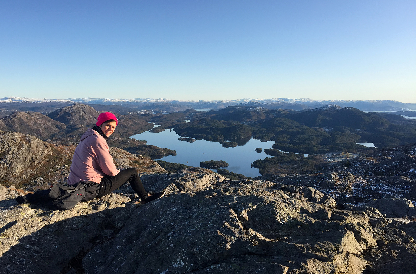
Eldsfjellet from the north
- Dato:
- 20.08.2023
- Turtype:
- Fottur
- Turlengde:
- 4:00t
- Distanse:
- 8,0km
 We had not been on Eldsfjellet for a while -- not the two of us, at least! Eldsfjellet is -- for good reasons -- a relatively popular hiking destination (it's not really high, as a mountain, but since it's standing out of its surrounding quite a bit, one can expect quite nice views from its heights). Here on Peakbook, as well as on other hiking platforms, one can easily get the impression that everyone (or "everyone") hikes up to Eldsfjellet from its south, either from the parking spot near Alvhøyen along Skjelangervegen, or from Skurtveit via Skurtveitvegen. Harald 's approach from the northwest is a notable exception, of course! :-) Even though it looked like off-trail a lot, we made a plan to approach Eldsfjellet from the north, instead. The idea was to follow Skjelangervegen further and around Eldsfjellet, >>>
Gaustadfjellet, Litlafjellet, Bårafjellet, Øyjordsfjellet
- Dato:
- 04.09.2022
- Turtype:
- Fottur
- Turlengde:
- 6:30t
- Distanse:
- 11,4km
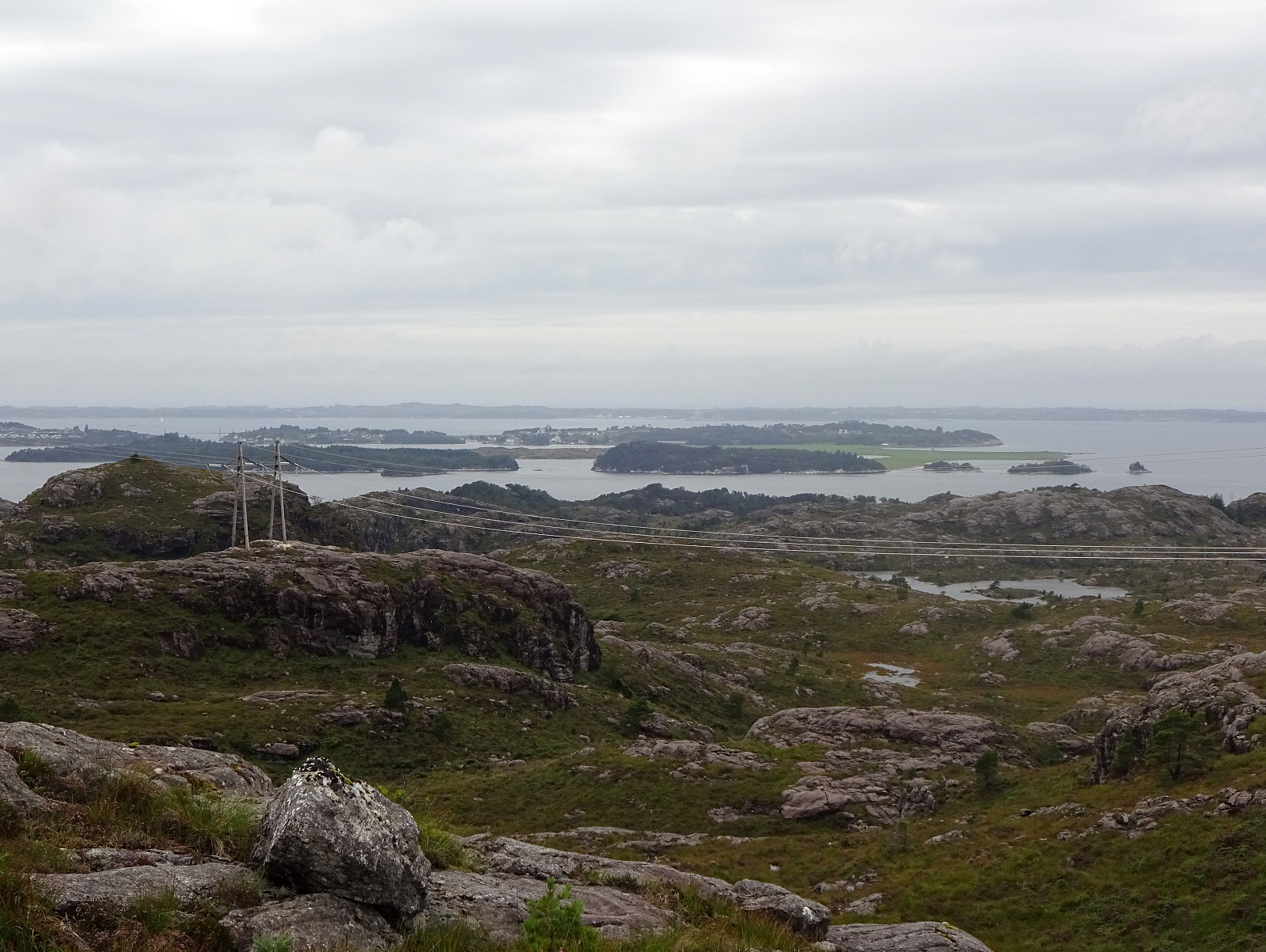
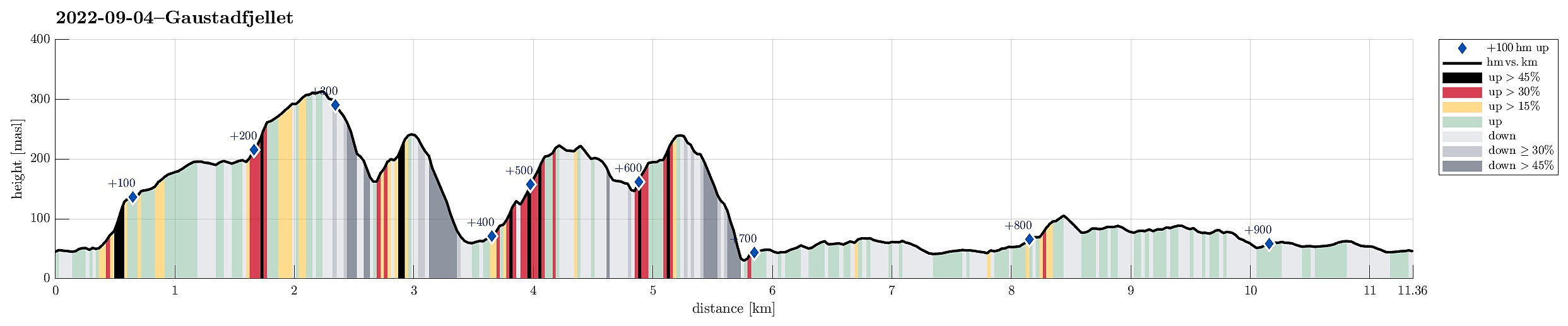 Looking forward to a nice day, we decided to pay Gaustadfjellet on Holsnøy a visit. To get there, we crossed Krossnessundet right after driving over Nordhordlandsbrua, north of Bergen. Then, we followed road 5310 northwestwards, kind of parallel to Radfjorden on our right side. Since we wished to start our hike from the southeast, traversing all of Gaustadfjellet (and further), we first needed to find a proper parking place along Ådlandsvegen. After a bit of back and forth, we managed to park properly along this rather narrow road. We then followed a not really well visible trail to the southern ridge of Gaustadfjellet (Storhøyden). From there, then, we could use a nice trail that extends over most of this ridge. It's actually a very nice alternative to the otherwise shorter ascent >>>
Round around Meland church
- Dato:
- 21.11.2021
- Turtype:
- Fottur
- Turlengde:
- 4:00t
- Distanse:
- 8,6km
 Expecting a nice November Sunday, we aimed at a round around Meland church near Knarvik in the north of Bergen. Driving along E39 from Bergen brought us across Salhusfjorden with the help of Nordhordlandsbrua. As soon as we touched ground on Flatøy, again, we changed to Rosslandsvegen, leading westwards into the direction of Meland and Holsnøy. Near Frekhaug, we turned right (onto the comparably narrow road to Meland). After crossing over from Dale to Meland, we parked near Meland church and started our hike from there. The first sub-goal of the day was Salbukletten in the northwest of Meland. We passed by Erstad, first, and then ascended from there to Salbukletten (into northwestern direction from Erstad). This ascent, even though without trail, was nice and easy! On Salbukletten, >>>
Brakstadfjellet, Tveitanipa, and Røysetfjellet
- Dato:
- 10.04.2020
- Turtype:
- Fottur
- Turlengde:
- 3:30t
- Distanse:
- 9,2km
 The weather report suggested the further north one may have better chances for some sunshine. So, a top, which had been waiting on our wish-list for a long time already, got picked as trip goal: Brakstadfjellet. The car brought us north from Bergen and over Nordhordlandsbrua. Turning left at Flatøy brings one over the bridge over Krossnessundet onto Holsnøy. Following road 564, we passed Frekhaug into the direction of Fløksand. Near Holme, we turned right (onto road 5314), driving further to Tveit. Eventually using road 5308, we ended up near Brakstadvatnet at Vollo. There, a somewhat extended bus stop offers good opportunities for parking. Before starting from Bergen, we had checked the map in order to understand, which alternatives there are for ascending to Brakstadfjellet. This >>>
Veten and Varden on Eldsfjellet
- Dato:
- 10.11.2019
- Turtype:
- Fottur
- Turlengde:
- 3:00t
- Distanse:
- 8,1km
 Starting from Bergen, we drove northwards, first, crossing over Nordhordlandsbrua on road E39. On the other side, instead of further following the main road, we turned left and onto road 564 that extends in northwestern direction on the southwestern side of Holsnøy. Eldsfjellet is found quite far in the northwest of Holsnøy and we aimed at parking near Skurtveit, only a bit after coming through Vikebø at Rosslandspollen. Close to Svehaugane, just a few meters up from the sea at Rosslandsvegen, we found a parking opportunity near a place, where apparently the bus also turns around. From there, we started our hike along Skurtveitvegen, first. We followed some minor roads to a point right in the south of Storatjørna from where a trail is starting in northern direction. Passing by Storatjørna >>>
Gaustadfjellet, Litlafjellet, Bårafjellet, Øyjordsfjellet
- Dato:
- 14.04.2017
- Turtype:
- Fjelltur
- Turlengde:
- 3:45t
- Distanse:
- 7,3km
 With a very promising spring day ahead, we decided to try some new top(s) in the north of Meland, i.e., Gaustadfjellet and others. We took road E39 northwards from Bergen, crossed Nordhordlandsbrua, and connected then to the small road #245 that departs from the road to Frekhaug right after the bridge to Meland. We then followed this narrow road northwards until we arrived at Ådland. We parked, where Kyrkjesundvegen departs in northern direction.
On the map, we had seen that approximately 200m south of this point, a path up to Gaustadfjellet should be possible to find---getting there, however, required a little bit of good orientation (and one more look at the map, actually). Once on this path, however, the ascent to Gaustadfjellet is straight-forward and quick. From the top of Gaustadfjellet, >>>
With a very promising spring day ahead, we decided to try some new top(s) in the north of Meland, i.e., Gaustadfjellet and others. We took road E39 northwards from Bergen, crossed Nordhordlandsbrua, and connected then to the small road #245 that departs from the road to Frekhaug right after the bridge to Meland. We then followed this narrow road northwards until we arrived at Ådland. We parked, where Kyrkjesundvegen departs in northern direction.
On the map, we had seen that approximately 200m south of this point, a path up to Gaustadfjellet should be possible to find---getting there, however, required a little bit of good orientation (and one more look at the map, actually). Once on this path, however, the ascent to Gaustadfjellet is straight-forward and quick. From the top of Gaustadfjellet, >>>
Eldsfjellet
- Dato:
- 19.01.2008
- Turtype:
- Fjelltur
- Turlengde:
- 2:00t
- Distanse:
- 3,2km
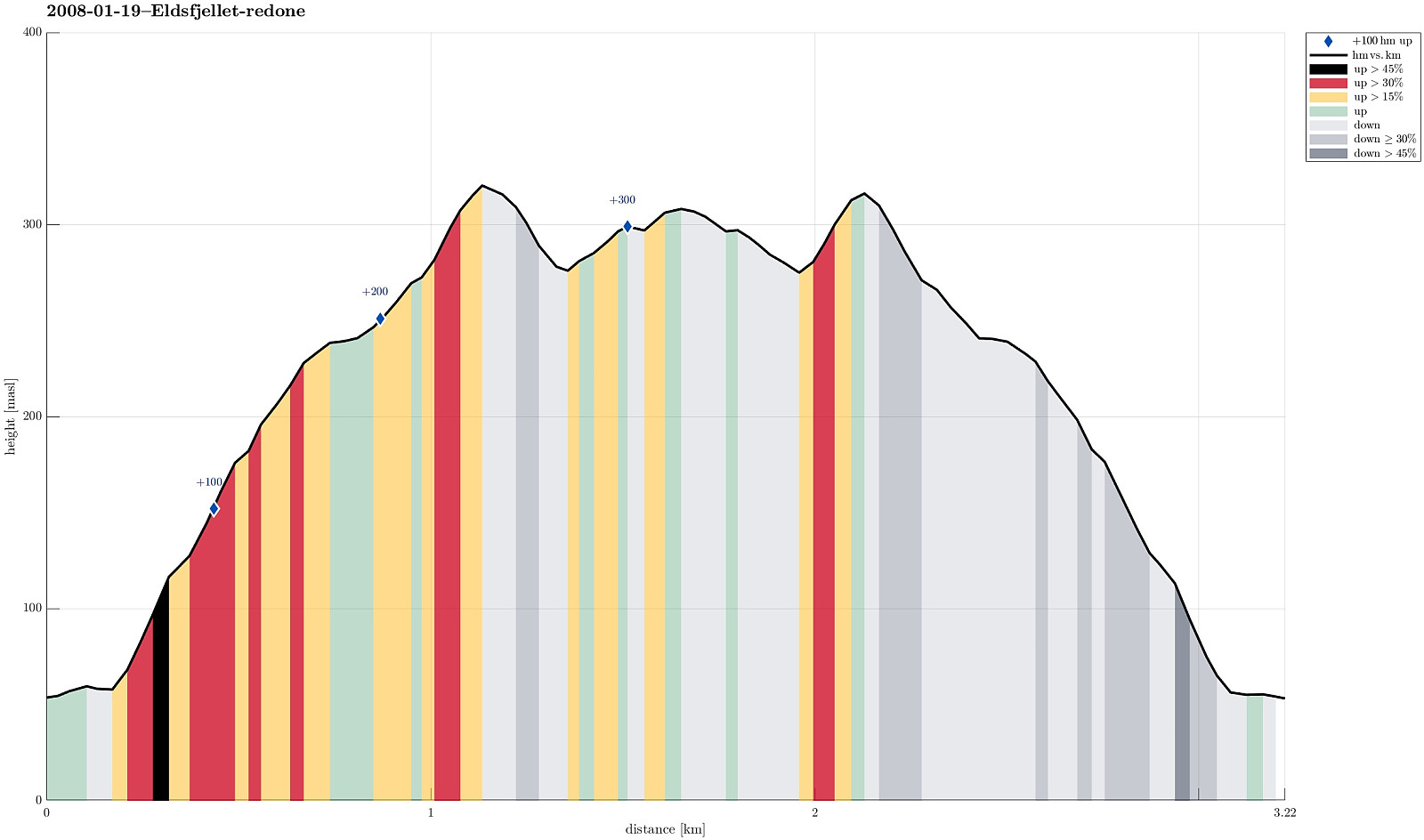 Impressive hike (with an intense hail storm!) up and down Eldsfjellet
