Arkiv - dato
Arkiv - aktivitet
-
Annen tur (1)
- Kajakkpadling (1)
-
Annen vintertur (4)
- Trugetur (4)
- Fottur (740)
-
Skitur (4)
- Fjellskitur (4)
-
Sykkeltur (137)
- Blandet sykling (51)
- Gatesykling (9)
Arkiv - Etter geografi
"Peakbookvenner"


Lister jeg samler etter
-
Bergen ≥ 50m pf. og ≥ 100 m.o.h.
(87/89)
 97%
97% -
Most dominating tops of the Bergen peninsula
(68/75)
90%
-
Utvalgte topper og turmål i Bergen
(316/350)
90%
-
Alle topper i Bergen
(357/398)
89%
-
Opptur Bergen
(100/113)
88%
-
De syv fjell rundt Bergen
(6/7)
85%
-
Sund ≥ 50m pf.
(14/18)
77%
-
Os ≥ 50m pf.
(25/34)
73%
-
Søyler (fastmerker) i Bergen
(68/100)
68%
-
Fjell ≥ 50m pf.
(21/32)
65%

Stangfjellet and Vedafjellet
- Dato:
- 19.04.2020
- Turtype:
- Fottur
- Turlengde:
- 5:30t
- Distanse:
- 14,9km
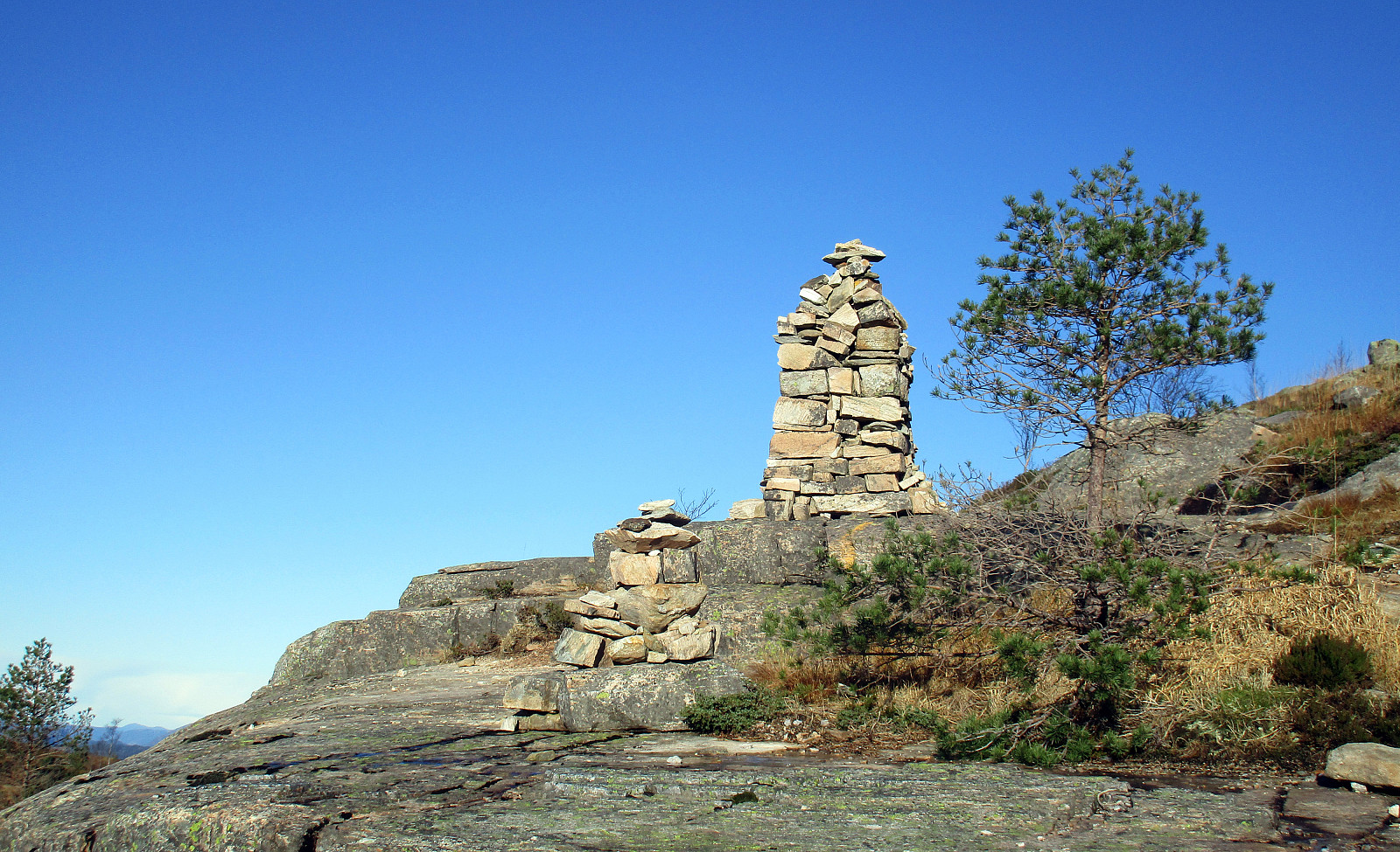
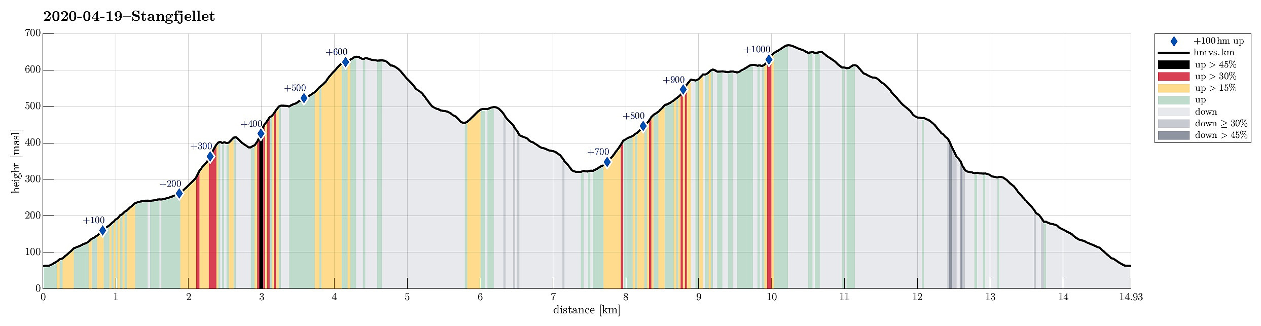 With a nice day ahead of us, we decided to try a hiking round, which we had looked at already repeatedly over several years, including Stangfjellet and Vedafjellet on Osterøy. After some consideration of the available time, etc., we decided to start from Gjerdstad. After leaving E16 for the bridge to Osterøy, we crossed over and used the tunnel on the other side (into the direction of Lonevåg). Following street 566 further upwards, we turned right near Rolland, continuing on Gjerdstadvegen. After some 5km, or so, we came to Gjerdstad, seeing the church there prominently on the right side. Turning right and crossing the stream using the narrow bridge there, we were right at the church and parked there. Before even starting our hike, we first looked at a large memorial stone, opposide >>>
Erstadfjellet and Hånipa
- Dato:
- 09.04.2020
- Turtype:
- Fottur
- Turlengde:
- 4:15t
- Distanse:
- 11,7km
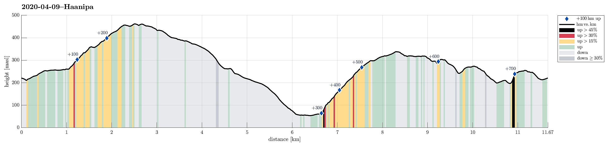 Trying to find a good spot for social distancing in this "special year" 2020, we aimed at the very west of Osterøy. The one little height, which we still had on our wish-list, Hånipa, with its apparently very steep western side, attracted us (for a longer time already) with a promise of nice views down to Sørfjorden. To make this a nice round, we parked near Askeland, about 200 height-meters above Votlo. From there, we first walked into Askelandsdalen (in eastern direction), before ascending relatively steeply to Setleitet (with some nice views down to Askelandsvatnet on the other side). Turning left, we started our ascent to Erstadfjellet (via Merkjedalsstølen). Crossing over Erstadfjellet, and only spending a few minutes up there to enjoy some nice views across Sørfjorden >>>
Brøknipa from Skaftå
- Dato:
- 21.09.2019
- Turtype:
- Fottur
- Turlengde:
- 6:15t
- Distanse:
- 15,7km
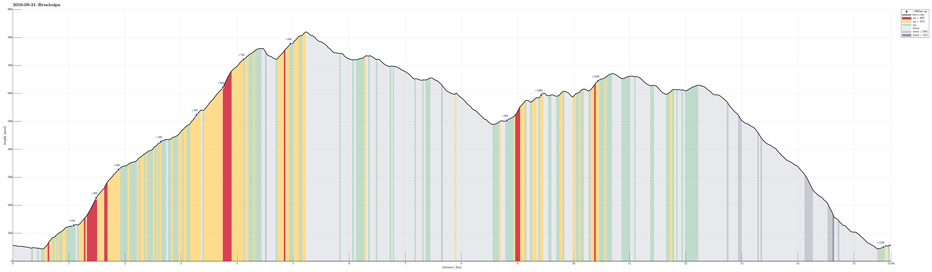 We took the car from Bergen to Osterøy (first along E16, then across the bridge). Right after crossing the bridge, we turned right (into the direction of Bruvik). Following Bruvikvegen, we soon after arrived at Skaftå, where we parked next to the road. We then walked a few meters in order to get started with our hike up to Brøknipa. When checking the information board at the beginning of the hike (right next to Bruvikvegen), we detected a dotted line that suggested that one could hike up directly to Utegardsnipa (instead of first going along Skaftådalen to Stølane before then turning back and up to the ridge that leads to Utegardsnipa). We thus adapted our plans to try out this route. We started "the usual way" (towards Skaftådalen), but at about 100mosl we found a little >>>
Brøknipa from Båtaleitet parking
- Dato:
- 19.07.2019
- Turtype:
- Fjelltur
- Turlengde:
- 3:00t
- Distanse:
- 5,3km
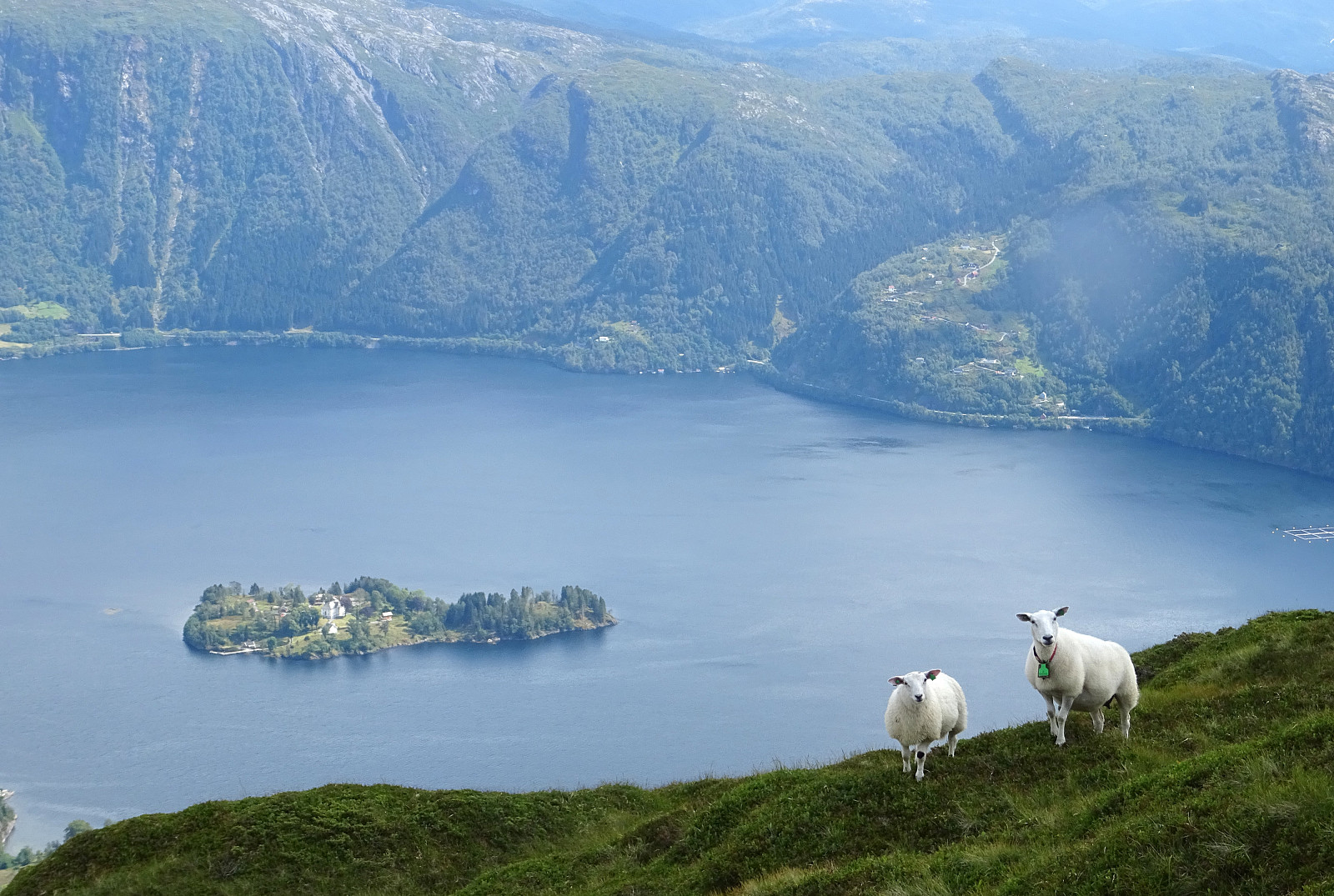 We started from Båtaleitet parking, quite a bit above Bruvik on Osterøy (to the right, right after crossing the bridge). Following the easy-to-find trail, we soon arrived at the top of Brøknipa (Bruviknipa), enjoying some very nice views over Sørfjorden from up there (it's always wonderful to stand on top of Brøknipa -- very much recommended!). After spending a bit of time on the top, we then returned back down on the same trail that we had taken up. A nice (not too long) hike with great views! :-)
Selected photos are available as Google photo album .
See also the related FB-page Hiking around Bergen, Norway .
Petter Bjørstad has a a useful page about Brøknipa ; and also web page WestCoastPeaks.com provides useful information about Brøknipa (he writes "In my personal opinion, Brøknipa is one of Hordaland's finest mountains").
We started from Båtaleitet parking, quite a bit above Bruvik on Osterøy (to the right, right after crossing the bridge). Following the easy-to-find trail, we soon arrived at the top of Brøknipa (Bruviknipa), enjoying some very nice views over Sørfjorden from up there (it's always wonderful to stand on top of Brøknipa -- very much recommended!). After spending a bit of time on the top, we then returned back down on the same trail that we had taken up. A nice (not too long) hike with great views! :-)
Selected photos are available as Google photo album .
See also the related FB-page Hiking around Bergen, Norway .
Petter Bjørstad has a a useful page about Brøknipa ; and also web page WestCoastPeaks.com provides useful information about Brøknipa (he writes "In my personal opinion, Brøknipa is one of Hordaland's finest mountains").
Vedafjellet and Brøknipa from Skaftå
- Dato:
- 12.05.2019
- Turtype:
- Fjelltur
- Turlengde:
- 5:15t
- Distanse:
- 16,0km
 We left Bergen via Arna, continuing along road E16 in the direction of Voss, before then taking the bridge to Osterøy. On the other side, we turned right onto the narrow road towards Bruvik and followed it (on the northern side of Sørfjorden) for quite a bit. After getting around Stokkaneset and before driving into Skaftå, we parked near the sharp right-turn, which is built over the stream that comes down from Djupedalen. Right there, we forest road leaves to the north (and upwards), following Djupedalen for a short stretch (before turning left and upwards). We continued to walk up this forest road until it eventually swings to the left for good (at about 135mosl). There, we found the trail head, as planned. After a few meters of leading further northwards, the trail crosses a little >>>
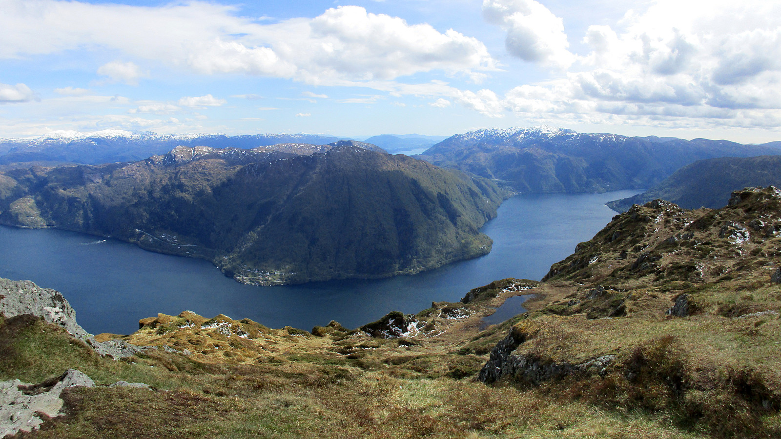
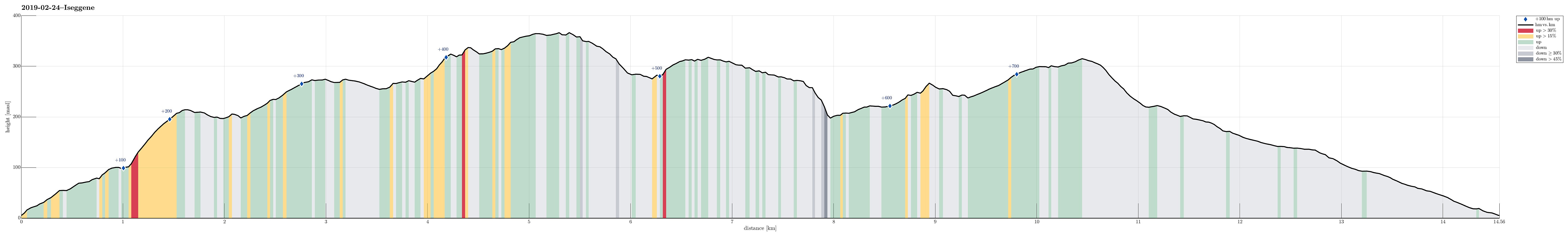
Iseggene, Storefjellet, and Fårikken
- Dato:
- 24.02.2019
- Turtype:
- Fjelltur
- Turlengde:
- 4:00t
- Distanse:
- 14,6km
 We took the car to Valestrand on Osterøy and parked near a playing ground not far from where the ferry arrives/leaves. In order to get up to Eidefjellet, we traversed a "labyrinth" of small roads up the northwestern side of Valestrand. Soon we arrived near the top-most house and found the trail head right next to it. From there, the continuation was nice and easy to find, following the ridge up in northwestern direction. After crossing Kjeringfjellet, we continued along the ridge (in northwestern direction). Before the trail swings to the right, in order to connect with Iseggene, we left the main path for a short excursion to Brattfjellet. Without finding any path there, we quickly ended up in quite a bit of vegetation, requiring a bit of explorer spirit to continue. After >>>
Rispingen on a beautiful day!
- Dato:
- 27.10.2018
- Turtype:
- Fjelltur
- Turlengde:
- 3:30t
- Distanse:
- 11,2km
 We took the car from Bergen to Osterøy (via the bridge east of Arna) and continued then further to Bruvik along Sørfjorden, before we eventually drove up northwards (between Brøknipa and Olsnesnipa) through Bjørndalen until we parked at the large parking spot at Båtaleitet (about 350mosl). From there, we hiked along the path which leads up to Skarvenipa via Flærne (on the west of Øvstebotnen). We then continued (still on the path) towards Rispingen, coming close to Raudskredbruna. Instead of continuing on the path (directly to Rispingen), we circled Raudskredtjørna on its northeast and ascended the short stretch to Raudskredbruna, enjoying some nice views from up there. From there, we decided to head back to the path (instead of descending further down towards Stemmetjørna) and >>>
Nonkletten, Sørkletten, and Klubben
- Dato:
- 05.10.2018
- Turtype:
- Fjelltur
- Turlengde:
- 3:00t
- Distanse:
- 8,4km
 After a nice meeting in Fotlandsvåg, I wanted to use the afternoon to do a little hike nearby. Looking at the map, I got interested in a round near Kleppsvatnet, including Nonkletten, Sørkletten, and Klubben. I drove across Kleppsskaret and down to Kleppsvatnet (its southern end) and parked right next to the southernmost end of the lake.
From there, I headed into the direction of Nonkletten, parallel to the lake. The first (short) stretch was still a forest road, leading up to a small saddle. On the other, northern side, the road turned more and more into water until it got completely exchanged for a little stream, coming down from the northeast (and heading towards Kleppsvatnet). I first followed the stream upwards through the forest, before I decided to aim at a higher route towards >>>
After a nice meeting in Fotlandsvåg, I wanted to use the afternoon to do a little hike nearby. Looking at the map, I got interested in a round near Kleppsvatnet, including Nonkletten, Sørkletten, and Klubben. I drove across Kleppsskaret and down to Kleppsvatnet (its southern end) and parked right next to the southernmost end of the lake.
From there, I headed into the direction of Nonkletten, parallel to the lake. The first (short) stretch was still a forest road, leading up to a small saddle. On the other, northern side, the road turned more and more into water until it got completely exchanged for a little stream, coming down from the northeast (and heading towards Kleppsvatnet). I first followed the stream upwards through the forest, before I decided to aim at a higher route towards >>>
Hæddena and Hoklane
- Dato:
- 12.02.2017
- Turtype:
- Fjelltur
- Turlengde:
- 2:45t
- Distanse:
- 6,4km
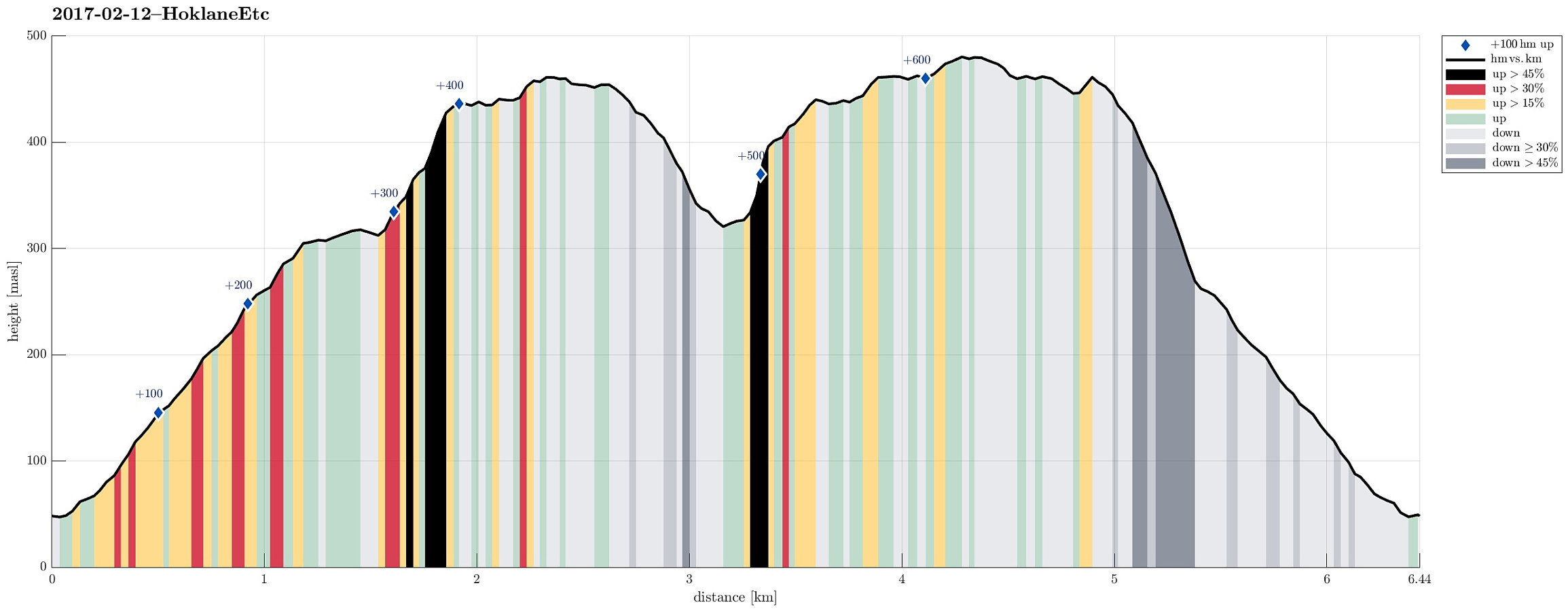 We drove to Arna from Bergen and continued (for a bit) on E16 until we came to the large bridge, which connects Osterøy for drivers. We crossed the bridge and took the first turn to the right (into the direction of Bruvik), instead of entering the long tunnel that leads further inlands and north on Osterøy. We drove this narrow and winding road a little bit to the east until we came to a small place called Blom. There we parked our car along the "main road" (at the eastern end of Blom), after we had asked and checked that this was OK.
From the car we first walked a few meters back (in northwestern direction), following a narrow secondary road that connects to the few buildings of Blom. Only a few meters up this small road, one can easily find the trail head for this hike (there >>>
We drove to Arna from Bergen and continued (for a bit) on E16 until we came to the large bridge, which connects Osterøy for drivers. We crossed the bridge and took the first turn to the right (into the direction of Bruvik), instead of entering the long tunnel that leads further inlands and north on Osterøy. We drove this narrow and winding road a little bit to the east until we came to a small place called Blom. There we parked our car along the "main road" (at the eastern end of Blom), after we had asked and checked that this was OK.
From the car we first walked a few meters back (in northwestern direction), following a narrow secondary road that connects to the few buildings of Blom. Only a few meters up this small road, one can easily find the trail head for this hike (there >>>
Erstadfjellet and Stemmeseggi
- Dato:
- 13.11.2016
- Turtype:
- Fjelltur
- Turlengde:
- 2:30t
- Distanse:
- 7,2km
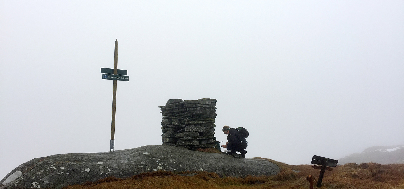 We drove from Bergen towards the East and left the E16 to cross Sørfjorden towards Osterøy on the large bridge. We drove then to Haus and further to Votlo, where we continued a few turns upwards (towards Askeland). We parked near the spot, where the street (towards Askeland) crosses the little stream, which comes down Askelandsdalen. From there, we started hiking; first into northwestern direction (further towards Askeland, somehow upwards, also). Only a few steps up this road, we found the path, which departed to the right, now in eastern direction (leading further upwards). This path clearly was a well-made path before, probably serving a little hut not far up the mountain-side. When we reached this hut (more the ruins of it), we turned left and ascended (now more steeply) over some >>>
