Arkiv - dato
Arkiv - aktivitet
-
Annen tur (1)
- Kajakkpadling (1)
-
Annen vintertur (4)
- Trugetur (4)
- Fottur (740)
-
Skitur (4)
- Fjellskitur (4)
-
Sykkeltur (137)
- Blandet sykling (51)
- Gatesykling (9)
Arkiv - Etter geografi
"Peakbookvenner"


Lister jeg samler etter
-
Bergen ≥ 50m pf. og ≥ 100 m.o.h.
(87/89)
 97%
97% -
Most dominating tops of the Bergen peninsula
(68/75)
90%
-
Utvalgte topper og turmål i Bergen
(316/350)
90%
-
Alle topper i Bergen
(357/398)
89%
-
Opptur Bergen
(100/113)
88%
-
De syv fjell rundt Bergen
(6/7)
85%
-
Sund ≥ 50m pf.
(14/18)
77%
-
Os ≥ 50m pf.
(25/34)
73%
-
Søyler (fastmerker) i Bergen
(68/100)
68%
-
Fjell ≥ 50m pf.
(21/32)
65%

Knappen (alternative route)
- Dato:
- 31.07.2016
- Turtype:
- Fjelltur
- Turlengde:
- 2:00t
- Distanse:
- 4,3km
 We started from Varden, walking down Marineveien and connecting to Bjørgeveien, where we turned left into Sandeidbrotet after only a few meters along Gjeddevatnet. This little side-street leads steeply up (into the direction of Knappatjørna). At "the top", where the street makes a sharp turn to the left, a hiking path leaves to the right (only a few meters above another side-road, which only connects to a private place instead). Following the hiking path (into northwestern direction) brings one nearby Røstafjellet, i.e., another residential area (north of Knappen and slightly elevated above Bjørgeveien). Before actually entering this area, another hiking path leaves to the left and upwards, first in western direction, but then, following the ridge, turning more and more into >>>
Livarden from Unneland (wild!)
- Dato:
- 25.06.2016
- Turtype:
- Fjelltur
- Turlengde:
- 3:00t
- Distanse:
- 7,8km
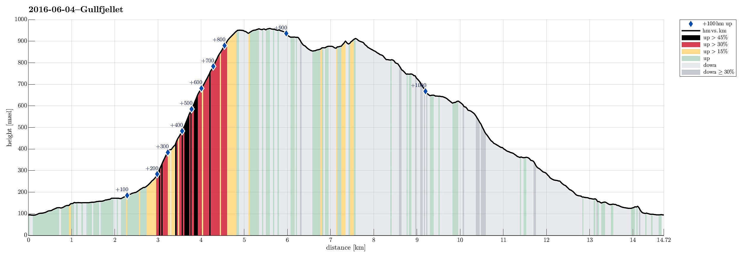
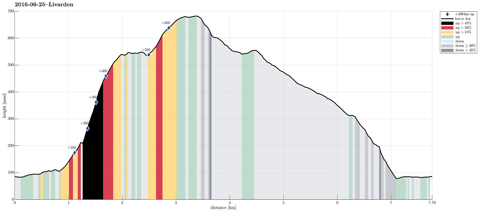 We parked near Li, Unneland, and continued, walking, along Unnelandsvegen until we came to Gullfjellsvegen. We followed this road just for a few meters ( around the corner , basically), before we stepped over the little water, which comes down from Seterdalen. After a little forth and back, we found what looked like the path up towards Rambjørgsgjelet (in southern direction). At Glisningane, this path gets very close to Rambjørgselva, which jumps down through Rambjørgsgjelet. We followed this path as much up as we could, until it ended for sure at about 200m above sealevel. There it was pretty unclear of how to proceed best (through the wild). Remembering, what the map looked like (roughly), we decided to step over Rambjørgselva to the other (western) side and ascend (steeply!!) towards >>>
Sveningen from Hausdalen
- Dato:
- 12.06.2016
- Turtype:
- Fjelltur
- Turlengde:
- 6:30t
- Distanse:
- 13,5km
 This time, we had two cars, so we parked one at the very end of Hausdalen (where Brekkedalen starts). We then took the other car to get to our starting point, a little further out Hausdalen (near Samdalsvatnet, Tømmervika, Straumsrinden, Hausdalsvegen 425---about 3.4 km away from the parking at the very end of Hausdalen). This start point for the hike is not 100% obvious and one needs to know, where to leave the street in Hausdalen. One then drives just a few meters up a gravel road, before there is space for two or three cars on the left side. From there, we followed the forrest road, first over Straumsrinden (passing by Samdalsvatnet). On its southern / southwestern end, one uses two bridges to get over the stream that continues further out Hausdalen. Only shortly after, one crosses >>>
Lyderhorn from Kjøkkelvik
- Dato:
- 11.06.2016
- Turtype:
- Fjelltur
- Turlengde:
- 1:30t
- Distanse:
- 3,5km
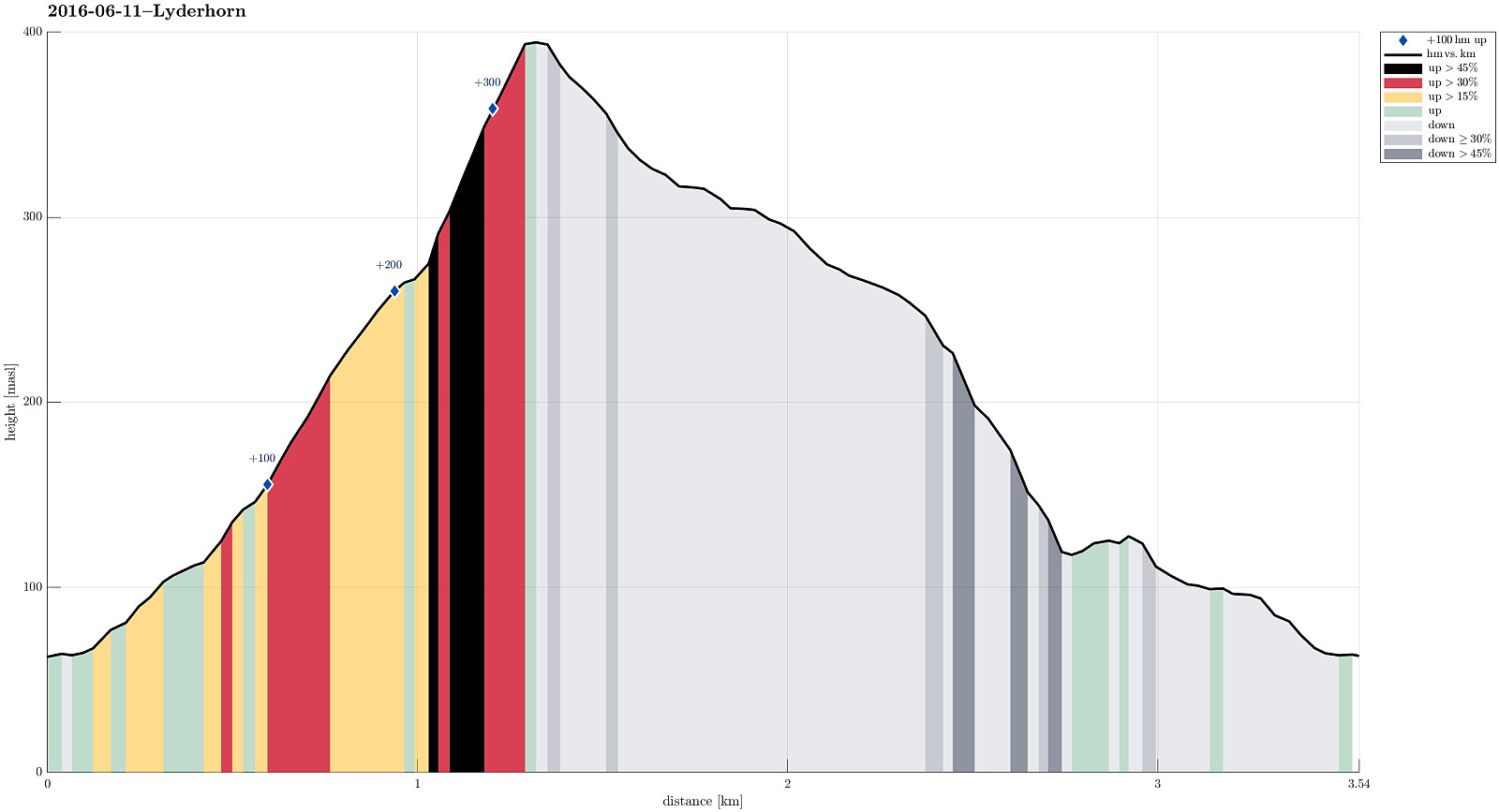 We started from nearby Kjøkkelvik school, ascending via Lyderhornslien into Olderdalen. The path follows a nice ridge up (first into southeastern direction, towards Små-Lyderhorn), before turning (steeply) left, right after reaching the saddle point. From there, it's then directly up to Lyderhorn (in northern direction). From the top of Lyderhorn, we continued northwards (and down). We first thought to step down a path to the upper end of Lyderhornslien, which is somehow parallel to the one we took up (a little further north). After having passed by the entry point to this path (which always is a little tricky to find!), we continued and decided to take the next path down (forking off to the left, west, right before getting to Høgenuten). This path leads to the upper end of Nedbergelien. >>>
Sydpolen from Brekkedalen and more
- Dato:
- 04.06.2016
- Turtype:
- Fjelltur
- Turlengde:
- 5:30t
- Distanse:
- 14,7km
 We parked at the end of the road in Hausdalen, near the bridge to Brekkedalen. We then followed the gravel road into Brekkedalen, first, before leaving this road (to the left) and ascending to Sydpolen via the steep ridge that comes down into Brekkedalen. We have hiked this route several times before and always this part (up to Sydpolen from Brekkedalen) is a special (and nice!) hiking challenge. This time, my challenge doubled as the sole of one of my hiking shoes detached just after 100m up, or so. With a short cord that I took of my backbag, I managed to bind the loose sole back to my shoe (somehow), but hiking was definitely different, afterwards! :-) With this short delay, we ended up at Sydpolen a few minutes later than expected---still, we enjoyed this part of the hike very much, >>>
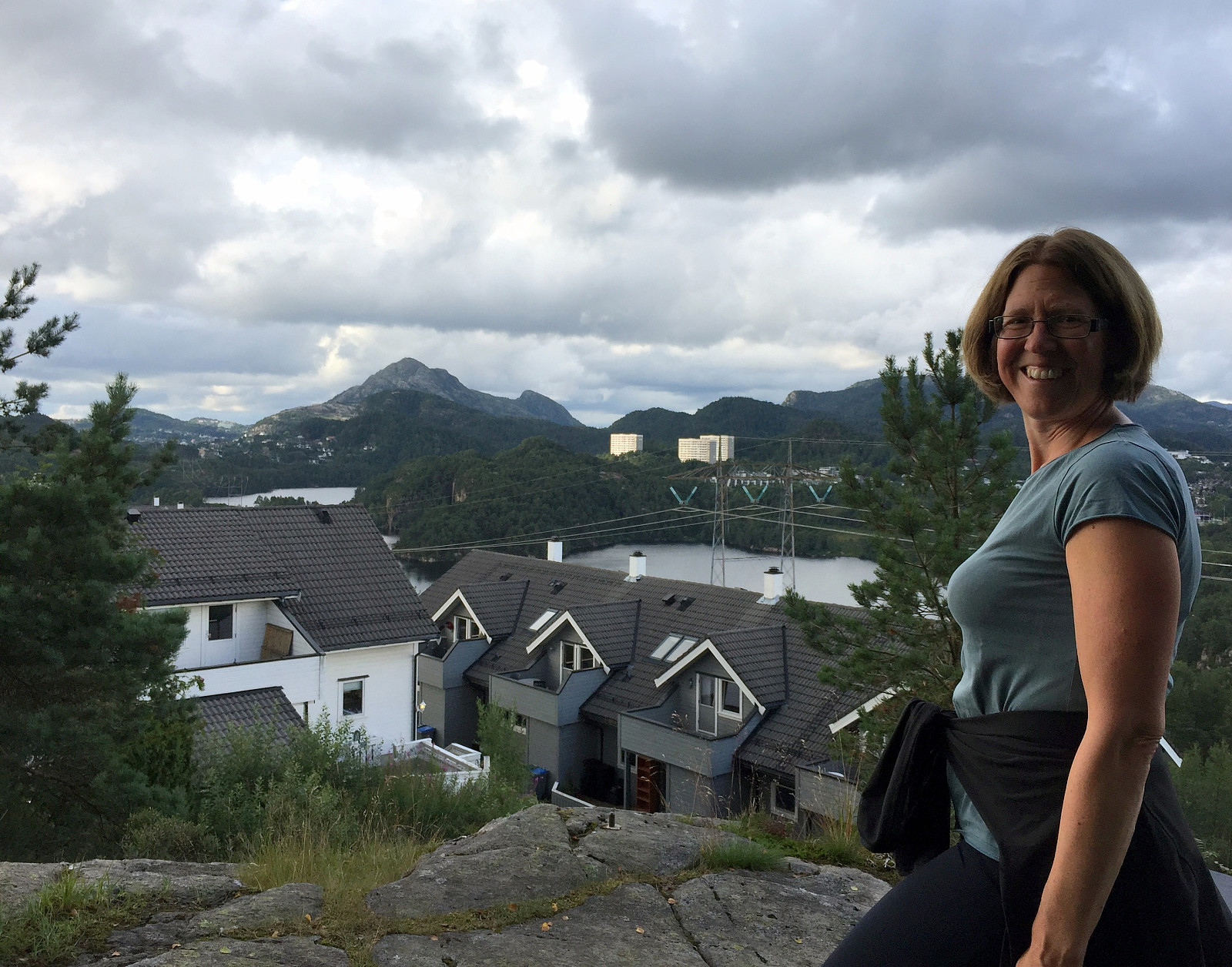
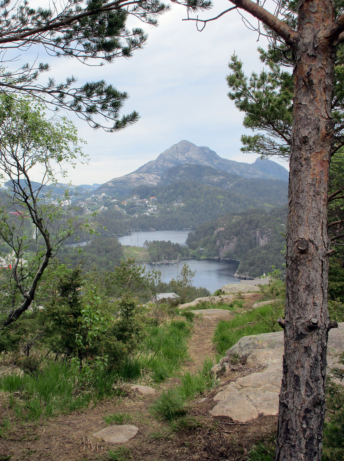
Knappen and Løvstakken
- Dato:
- 02.06.2016
- Turtype:
- Fjelltur
- Turlengde:
- 3:08t
- Distanse:
- 17,4km
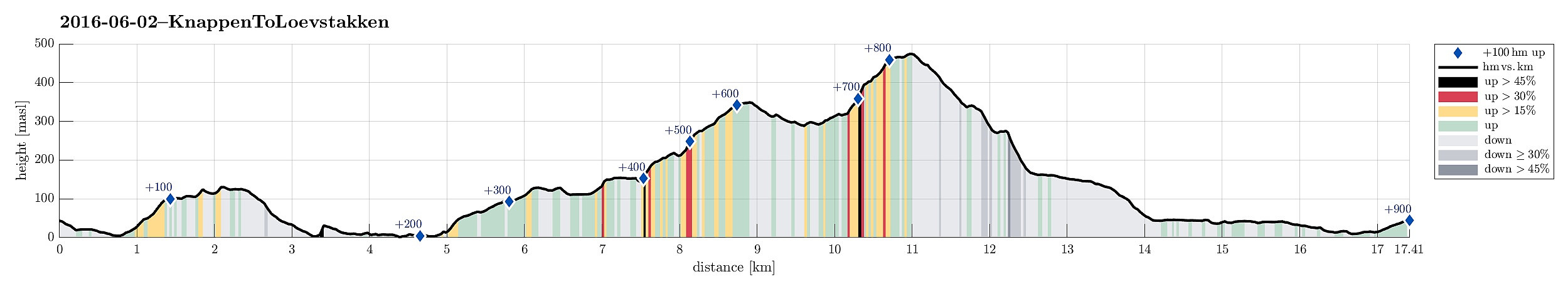 I started from Varden and went up Knappen, first. From there, I connected to Bønes, and from up there, further to Gullstølen and Gullsteinen. I then decided to also continue to Løvstakken, before descending back to Fyllingsdalen.
Selected photos are available as Google photo album .
See also the related FB-page Hiking around Bergen, Norway .
Web page WestCoastPeaks.com provides useful information about Løvstakken and also Petter Bjørstad has a useful page about Knappen .
Web page UT.no from the Norwegian Trekking Association recommends this hike (part of it), too.
On Bergentopp 200 there is a page (in Norwegian) about Løvstakken .
I started from Varden and went up Knappen, first. From there, I connected to Bønes, and from up there, further to Gullstølen and Gullsteinen. I then decided to also continue to Løvstakken, before descending back to Fyllingsdalen.
Selected photos are available as Google photo album .
See also the related FB-page Hiking around Bergen, Norway .
Web page WestCoastPeaks.com provides useful information about Løvstakken and also Petter Bjørstad has a useful page about Knappen .
Web page UT.no from the Norwegian Trekking Association recommends this hike (part of it), too.
On Bergentopp 200 there is a page (in Norwegian) about Løvstakken .
Kanadaskogen with Knappen, Svartaberget, etc.
- Dato:
- 28.05.2016
- Turtype:
- Fjelltur
- Turlengde:
- 3:00t
- Distanse:
- 12,6km
 Starting at Varden in Fyllingsdalen, I first got over and up to Knappen (around Knappatjørna). From Knappen, I continued to Eldtona and further over the top and down again to Bjørgelien. Following that street downwards, I got to Bjøgeveien in order to cross over Kjerreidvika to Bjørndalsskogen (right behind the supermarked along Kjerreidvika there is a steep path that leads up to Bjørndalsskogen). I then crossed the living area at Bjørndalsskogen, before ascending to Straumsfjellet, right north of Bjørndalsskogen. From Straumsfjellet, I found a path down to Bjørndalsbrotet, where I crossed underneath Bjørgeveien over to Kanadaskogen. I continued towards Bjørndalsvatnet, first, getting into the green area as soon as possible. Without really entering the path that rounds about >>>
Ulriken via Isdalen
- Dato:
- 14.05.2016
- Turtype:
- Fjelltur
- Turlengde:
- 3:30t
- Distanse:
- 10,2km
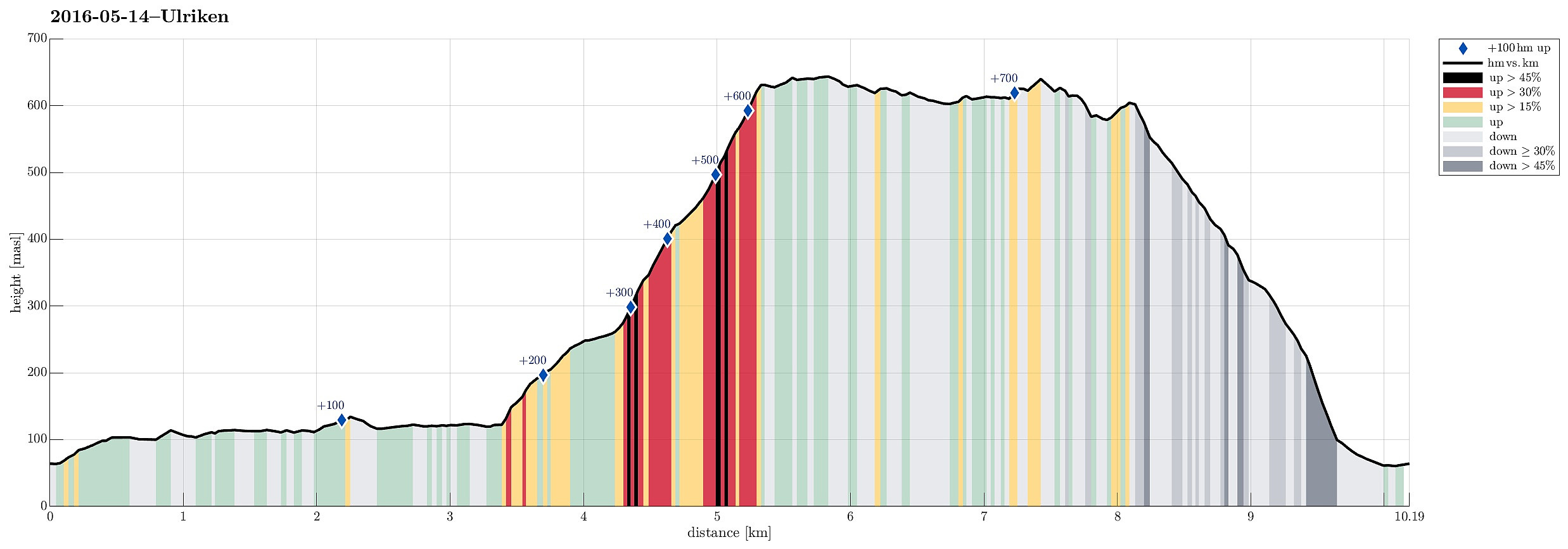 We parked right next to the big dam that holds Svartediket back and started walking along the northern side of Svartediket from there. Instead of following the main trail (up to the left) at the end of Svartediket, we continued along Tarlebøveien, crossing a small stream at the very back of the valley and turning right (in southern direction) there. Following the forrest road further, one starts to circle around Svartediket. After a short stretch, one comes to another small bridge, which crosses the stream that jumps down through Isdalen. Right there, not very well visible, though, one needs to turn left (steeply up) and find the trail that then continues through Isdalen. While the trail head (next to the bridge) is not easy to see, the path then becomes very well visible and easy to >>>
Knappen
- Dato:
- 20.03.2016
- Turtype:
- Fjelltur
- Turlengde:
- 1:30t
- Distanse:
- 5,2km
 We started from Varden, Einerhaugen, crossed Bjørgeveien and ascended along Vassteigen towards Knappen. This time, however, we walked around Knappetjørna, first, before ascending to the "top" of Knappen. Afterwards, we basically took the same path back.
See also the related FB-page Hiking around Bergen, Norway .
Petter Bjørstad has a useful page about Knappen .
We started from Varden, Einerhaugen, crossed Bjørgeveien and ascended along Vassteigen towards Knappen. This time, however, we walked around Knappetjørna, first, before ascending to the "top" of Knappen. Afterwards, we basically took the same path back.
See also the related FB-page Hiking around Bergen, Norway .
Petter Bjørstad has a useful page about Knappen .
Langrinden (Ulriken)
- Dato:
- 17.03.2016
- Turtype:
- Fjelltur
- Turlengde:
- 1:00t
- Distanse:
- 2,6km
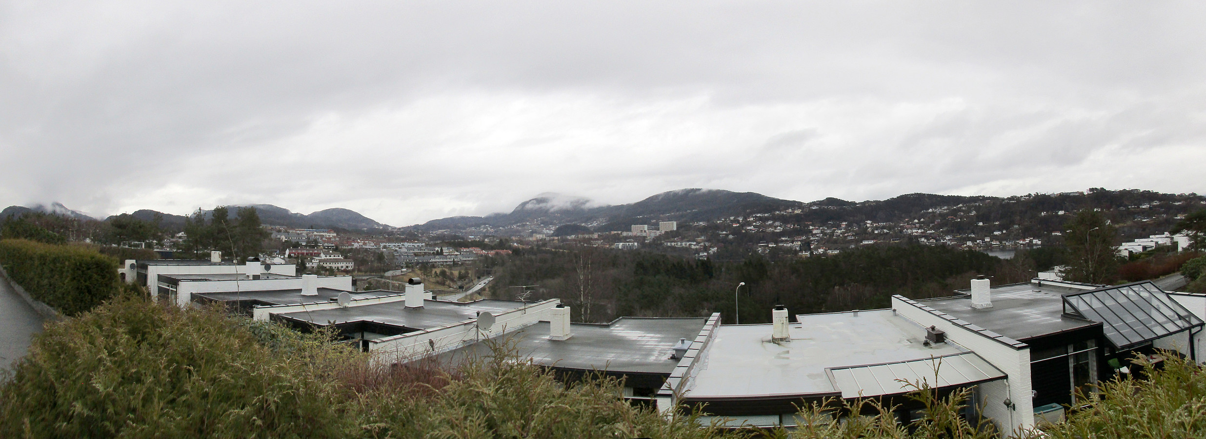
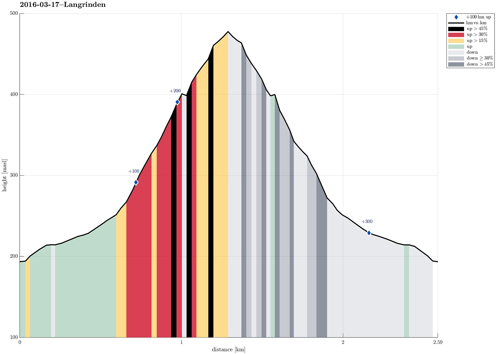 We started from Haggardshaugen (right above Montana Vandrehjem), followed Skiveien / Johan Blytts vei up to the point, where a little bridge crosses over a small stream. Instead of crossing the bridge, we turned left and followed the ridge up (first towards the power line mast, then along the ridge further up). This is a very nice way up to Ulriken. Since time was late, already, and it started to get dark (also, we reached the clouds at a point which is marked with Langrinden), we decided to not ascend all the way up to Ulriken, but turn around and go back, instead. All in all, a short and nice evening hike, right after work! :-)
Selected photos are available as Google photo album .
See also the related FB-page Hiking around Bergen, Norway .
Web page WestCoastPeaks.com provides useful information about Haugavarden, Ulriken, Storfjellet, and Landåsfjellet
and also Petter Bjørstad has a useful page about Ulriken .
Web page UT.no from the Norwegian Trekking Association recommends the same hike up Ulriken .
On Bergentopp 200 there is a page (in Norwegian) >>>
We started from Haggardshaugen (right above Montana Vandrehjem), followed Skiveien / Johan Blytts vei up to the point, where a little bridge crosses over a small stream. Instead of crossing the bridge, we turned left and followed the ridge up (first towards the power line mast, then along the ridge further up). This is a very nice way up to Ulriken. Since time was late, already, and it started to get dark (also, we reached the clouds at a point which is marked with Langrinden), we decided to not ascend all the way up to Ulriken, but turn around and go back, instead. All in all, a short and nice evening hike, right after work! :-)
Selected photos are available as Google photo album .
See also the related FB-page Hiking around Bergen, Norway .
Web page WestCoastPeaks.com provides useful information about Haugavarden, Ulriken, Storfjellet, and Landåsfjellet
and also Petter Bjørstad has a useful page about Ulriken .
Web page UT.no from the Norwegian Trekking Association recommends the same hike up Ulriken .
On Bergentopp 200 there is a page (in Norwegian) >>>
