Arkiv - dato
Arkiv - aktivitet
-
Annen tur (1)
- Kajakkpadling (1)
-
Annen vintertur (4)
- Trugetur (4)
- Fottur (740)
-
Skitur (4)
- Fjellskitur (4)
-
Sykkeltur (137)
- Blandet sykling (51)
- Gatesykling (9)
Arkiv - Etter geografi
"Peakbookvenner"


Lister jeg samler etter
-
Bergen ≥ 50m pf. og ≥ 100 m.o.h.
(87/89)
 97%
97% -
Most dominating tops of the Bergen peninsula
(68/75)
90%
-
Utvalgte topper og turmål i Bergen
(316/350)
90%
-
Alle topper i Bergen
(357/398)
89%
-
Opptur Bergen
(100/113)
88%
-
De syv fjell rundt Bergen
(6/7)
85%
-
Sund ≥ 50m pf.
(14/18)
77%
-
Os ≥ 50m pf.
(25/34)
73%
-
Søyler (fastmerker) i Bergen
(68/100)
68%
-
Fjell ≥ 50m pf.
(21/32)
65%

Skarsnosi from Jordalen
- Dato:
- 07.08.2020
- Turtype:
- Fottur
- Turlengde:
- 5:00t
- Distanse:
- 10,1km
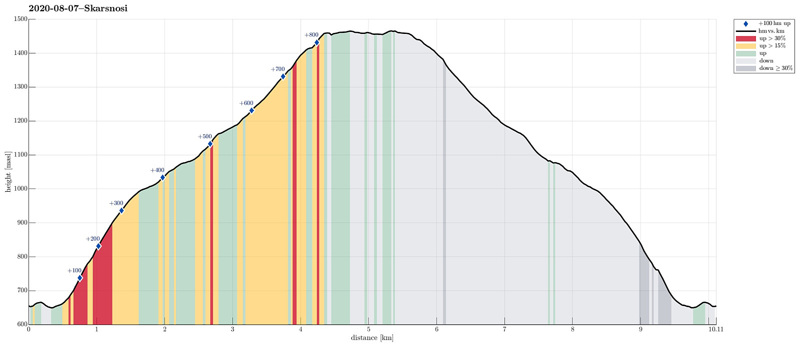 We expected a nice day and thought about Bakkanosi, since we had not been there before. Looking down onto Nærøyfjorden from this place sounds like a worthwhile experience! We thus drove along E16 into the direction of Gudvangen, passing by Stalheim. Quite a bit down in Nærøydalen, we then turned left and used the new tunnel up to Jordalen. Not far up in Jordalen, where Slettedalen comes down from the East, one would park to start the "standard hike" to Bakkanosi (through Slettedalen). Coming there, we were shocked about the relatively large number of parked cars and immediately changed our plan. Instead of Bakkanosi, we now planned for Skarsnosi, not far from Bakkanosi. To get up there, we had thought to hike up the next valley (north of Slettedalen). To do so, we drove >>>
Around Hopsdalen
- Dato:
- 31.07.2020
- Turtype:
- Fottur
- Turlengde:
- 8:30t
- Distanse:
- 22,4km
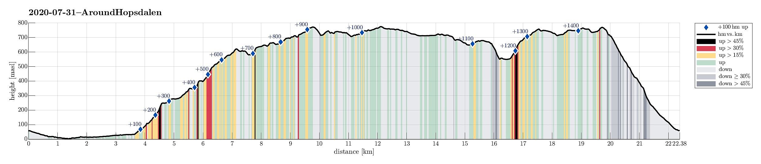 We drove along road E39 from Bergen northwards (into the direction of Masfjorden). After driving down through the long Masfjordtunnelen and passing through Matre at the very end of Matresfjorden, we crossed over to Haugsvær "behind" Nonklettfjellet. Before the main road (E39) disappears into another tunnel, we turned left in Haugsvær and parked right there.
Our (slightly ambitious) plan for the afternoon was to go around Hopsdalen (from Høgfjellet via Grønefjellet to Gavlen, and back via Rustefjellet). Considering the steep sides of Hopsdalen, we had looked at the map regarding a possible place for getting up to the top of the surrounding mountains. Near Indre Skjerjehogen, on the north side of Haugsværfjorden, we had thought that it should be possible to reach saddle Sygnegga >>>
We drove along road E39 from Bergen northwards (into the direction of Masfjorden). After driving down through the long Masfjordtunnelen and passing through Matre at the very end of Matresfjorden, we crossed over to Haugsvær "behind" Nonklettfjellet. Before the main road (E39) disappears into another tunnel, we turned left in Haugsvær and parked right there.
Our (slightly ambitious) plan for the afternoon was to go around Hopsdalen (from Høgfjellet via Grønefjellet to Gavlen, and back via Rustefjellet). Considering the steep sides of Hopsdalen, we had looked at the map regarding a possible place for getting up to the top of the surrounding mountains. Near Indre Skjerjehogen, on the north side of Haugsværfjorden, we had thought that it should be possible to reach saddle Sygnegga >>>
Blægja
- Dato:
- 29.07.2019
- Turtype:
- Fottur
- Turlengde:
- 7:00t
- Distanse:
- 10,1km
 After day #5 of our five days hike through Breheimen , we decided to a "bonus hike". After driving mostly westwards from Breheimen, we stayed in Førde for the night (our goal was to hike up Blægja the next day). The next morning, after driving further westwards from Førde, following road #609 along the southern coast of Førdefjorden, we parked between Hestvika and Rørvika near an information board, right next to the road. After walking down the road for a short stretch, we easily found the trail-head, leading southwards from the road. After first following a forest road for a short distance, the trail leaves to the right and into the forest (once you find it, it's then easy to follow). The path leads upwards, through the forest, staying on the eastern side of a valley, where water from Nipevatnet and Tobbedalsvatnet >>>
Breheimen, day 5: from Stølsdalen back to Skjolden
- Dato:
- 28.07.2019
- Turtype:
- Fottur
- Turlengde:
- 6:00t
- Distanse:
- 14,1km
 After day #4 of our five days hike through Breheimen , we continued from Stølsdalen with the goal to get to Turtagrø.
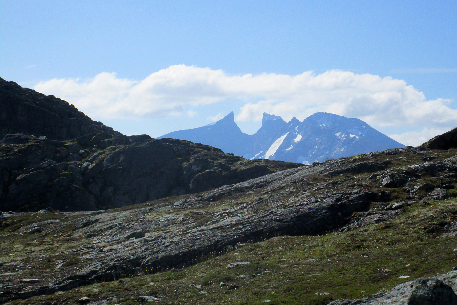
We first descended along Øvre Liagrø to get down into the valley (down to about 850mosl), before then ascending again on the other side (towards Skålabotnskaret). The first stretch upwards is interesting as it is quite steep and leading through a narrow valley, before one gets out and into Nedre Liagrø. From there, it's then nicely upwards until one gets to Skålabotnskaret at about 1340mosl. There, we decided to deviate from the marked trail in order to include Nosafjellet, also. Following the ridge west of the marked trail, we easily got close to Nosafjellet and also the final ascent was non-difficult (one needs to look a little to find a good spot). On the top of Nosafjellet, we enjoyed excellent views in all >>>
After day #4 of our five days hike through Breheimen , we continued from Stølsdalen with the goal to get to Turtagrø.
We first descended along Øvre Liagrø to get down into the valley (down to about 850mosl), before then ascending again on the other side (towards Skålabotnskaret). The first stretch upwards is interesting as it is quite steep and leading through a narrow valley, before one gets out and into Nedre Liagrø. From there, it's then nicely upwards until one gets to Skålabotnskaret at about 1340mosl. There, we decided to deviate from the marked trail in order to include Nosafjellet, also. Following the ridge west of the marked trail, we easily got close to Nosafjellet and also the final ascent was non-difficult (one needs to look a little to find a good spot). On the top of Nosafjellet, we enjoyed excellent views in all >>>
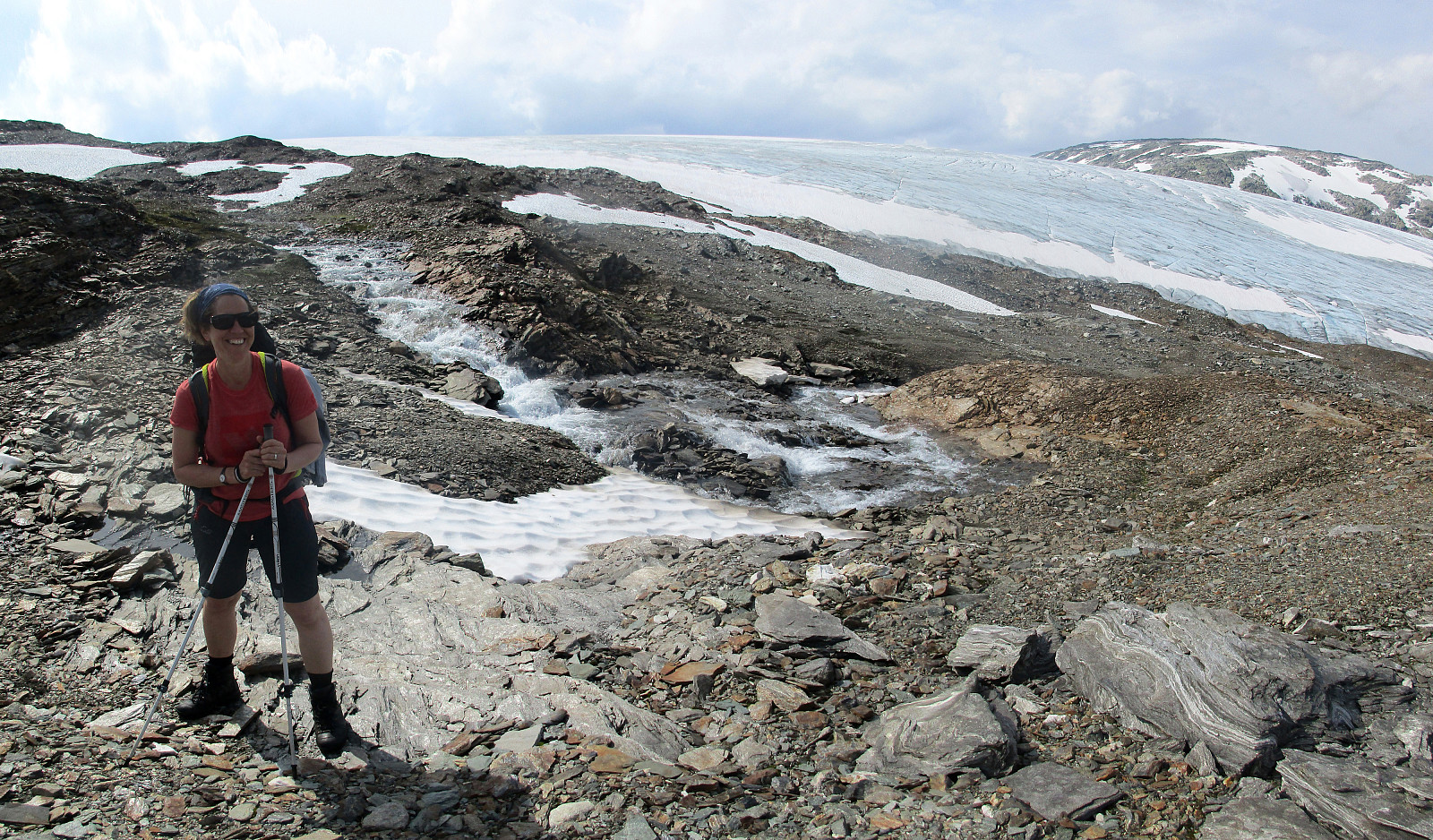
Breheimen, day 4: from Nørdstedalseter to Stølsdalen
- Dato:
- 27.07.2019
- Turtype:
- Fottur
- Turlengde:
- 8:00t
- Distanse:
- 16,6km
 After day #3 of our five days hike through Breheimen , we continued from Nørdstedalseter with the goal to get to Stølsdalen.
We started into eastern direction (into Vetledalen), following the hiking trail basically from the cabin (and not the road, which also extends into Vetledalen). This lead us gently upover (on the northern side of the valley), until we came to a part of the valley, where it gets quite a bit steeper. A bit above 1140mosl, the trails split with one leading further eastwards (through Vetledalen) and the other one southwards. The latter first crosses Vetledalen, before one starts with the ascent towards Liabreen. The path leads steadily (and moderately steep) upwards and it is (mostly) well-marked. At about 1400mosl, one gets close to the glacier (with a nice view, also, down to a glacial lake). Mostly avoiding >>>
After day #3 of our five days hike through Breheimen , we continued from Nørdstedalseter with the goal to get to Stølsdalen.
We started into eastern direction (into Vetledalen), following the hiking trail basically from the cabin (and not the road, which also extends into Vetledalen). This lead us gently upover (on the northern side of the valley), until we came to a part of the valley, where it gets quite a bit steeper. A bit above 1140mosl, the trails split with one leading further eastwards (through Vetledalen) and the other one southwards. The latter first crosses Vetledalen, before one starts with the ascent towards Liabreen. The path leads steadily (and moderately steep) upwards and it is (mostly) well-marked. At about 1400mosl, one gets close to the glacier (with a nice view, also, down to a glacial lake). Mostly avoiding >>>
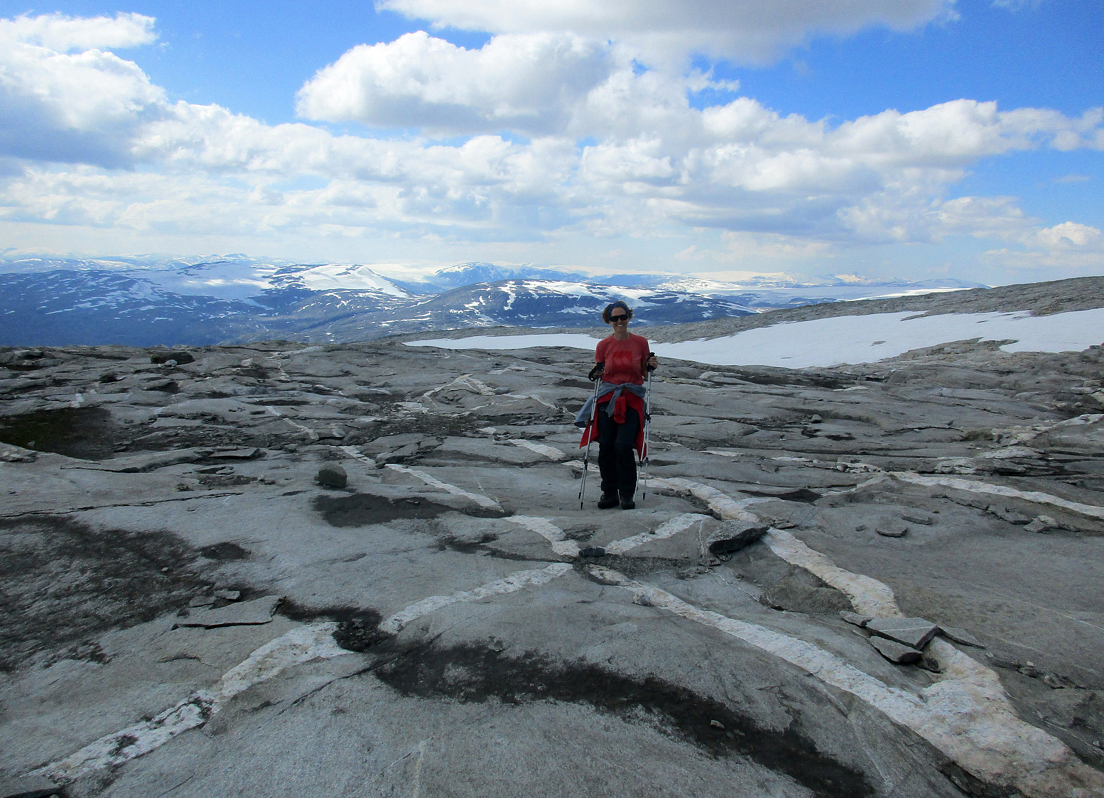
Breheimen, day 3: from Arentzbu to Nørdstedalseter
- Dato:
- 26.07.2019
- Turtype:
- Fottur
- Turlengde:
- 7:00t
- Distanse:
- 15,3km
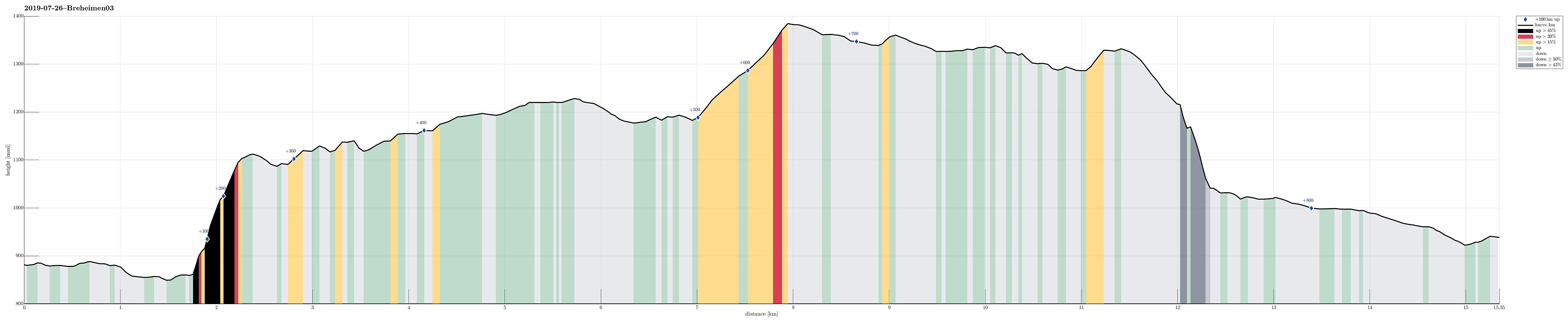 After day #2 of our five days hike through Breheimen , we continued from Arentzbu with the goal to get to Nørdstedalseter.
Only a few hundred meters from Arentzbu, we thanked those, who erected a bridge over the big and wild river, coming down through Rausdalen! :-) This way, it was straight-forward and easy to get over to the eastern side of the valley. We then followed the marked trail, which leads towards Heimsta Rausdalsvatnet, first (at Arentzbu, on the wall, a map, that apparently did not show the most up-to-date situation, indicated that the trail would lead up to Oksli "diagonally" across Kvanneskredene). After walking along this lake through comparably wet terrain for a bit, the trail then turns left (and steeply upwards to Oksli). About 250 height meters higher, the trail then flattens out, again, leading (almost >>>
After day #2 of our five days hike through Breheimen , we continued from Arentzbu with the goal to get to Nørdstedalseter.
Only a few hundred meters from Arentzbu, we thanked those, who erected a bridge over the big and wild river, coming down through Rausdalen! :-) This way, it was straight-forward and easy to get over to the eastern side of the valley. We then followed the marked trail, which leads towards Heimsta Rausdalsvatnet, first (at Arentzbu, on the wall, a map, that apparently did not show the most up-to-date situation, indicated that the trail would lead up to Oksli "diagonally" across Kvanneskredene). After walking along this lake through comparably wet terrain for a bit, the trail then turns left (and steeply upwards to Oksli). About 250 height meters higher, the trail then flattens out, again, leading (almost >>>
Breheimen, day 2: from Fast to Arentzbu
- Dato:
- 25.07.2019
- Turtype:
- Fottur
- Turlengde:
- 7:00t
- Distanse:
- 12,0km
 After day #1 of our five days hike through Breheimen , we continued from Fast with the goal to get to Arentzbu. The default idea was to follow the marked trail: first eastwards along the northern side of Åsetevatnet, then northwards (passing by Skurvenosi on its western side), before eventually continuing to Arentzbu along the southwestern side of Mørkrisdalen.
Instead, we cooked up an alternative route that would bring us much closer to the big glacier Spørteggbreen. We thus left the cabin at Fast in northwestern direction instead (without any marked or even well-visible trail) and headed into Langgrø, a nice valley with steep mountain sides to the left and right. Rougly 1km into the valley, we came around a gentle ridge, coming down from Soleibotnane. We felt invited to start ascending (more or less directly into the direction >>>
After day #1 of our five days hike through Breheimen , we continued from Fast with the goal to get to Arentzbu. The default idea was to follow the marked trail: first eastwards along the northern side of Åsetevatnet, then northwards (passing by Skurvenosi on its western side), before eventually continuing to Arentzbu along the southwestern side of Mørkrisdalen.
Instead, we cooked up an alternative route that would bring us much closer to the big glacier Spørteggbreen. We thus left the cabin at Fast in northwestern direction instead (without any marked or even well-visible trail) and headed into Langgrø, a nice valley with steep mountain sides to the left and right. Rougly 1km into the valley, we came around a gentle ridge, coming down from Soleibotnane. We felt invited to start ascending (more or less directly into the direction >>>
Breheimen, day 1: from Skjolden via Haugsnosi to Fast
- Dato:
- 24.07.2019
- Turtype:
- Fottur
- Turlengde:
- 9:00t
- Distanse:
- 18,9km
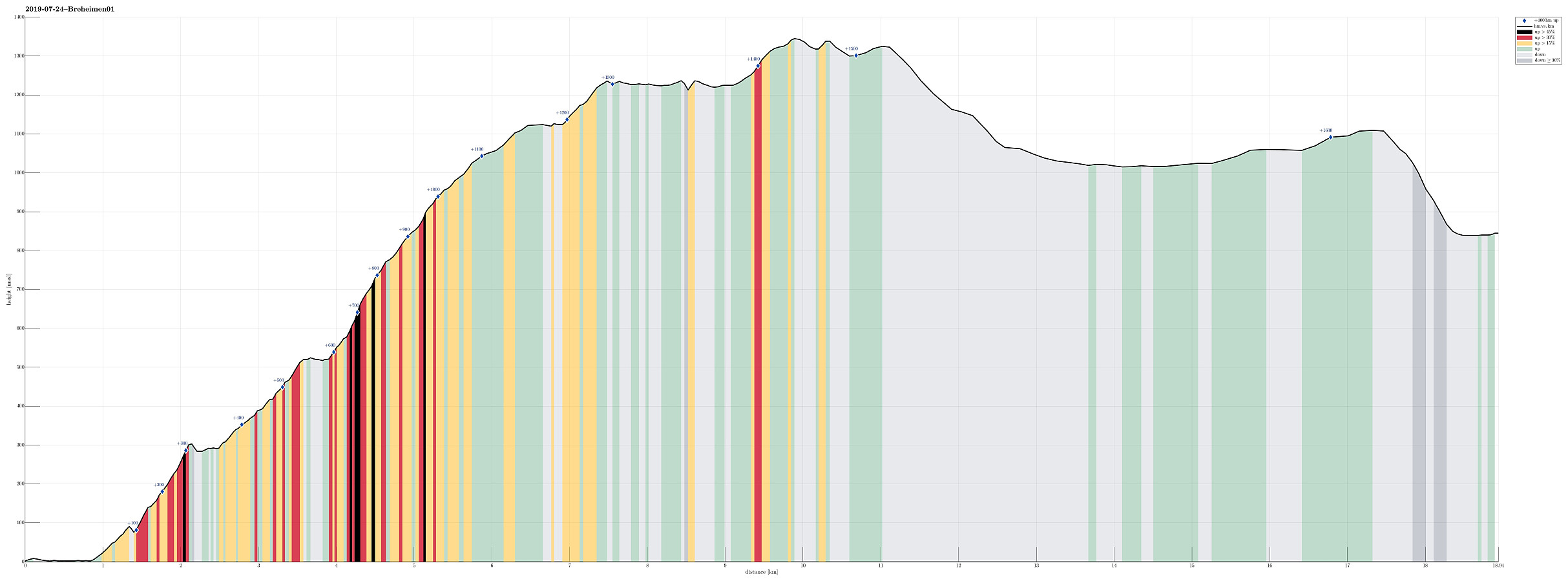 After our arrival in Luster the day before , we started our five days hike through Breheimen in Skjolden, Luster, at the very end of Sognefjorden (Lustrafjorden). On the map, we had seen that a trail should lead up to Persli from nearby Notasvaet, about 500m northwest of the bridge over Mørkriselvi in Skjolden, beginning with a forest road and then continuing "diagonally" upwards via Haukhammar to Stakkslettehaugen. The forest road was indeed easy to find, but then the continuation was completely unclear. We tried hard to locate the path through the forest, but could not find any (just very vague indications of someone, maybe a deer, having stepped there every now and then). We thus stepped through the (steep) forest upwards, into the direction of Stakkslettehaugen, without any path and at times proceeding was non-trivial. >>>
Around Vassbakken Camping near Skjolden
- Dato:
- 23.07.2019
- Turtype:
- Spasertur
- Turlengde:
- 2:00t
- Distanse:
- 5,4km
 After driving from Bergen to Skjolden (for getting started with our five days hike through Breheimen), we "landed" at Vassbakken Camping in the early evening. After eating dinner, we decided to do a bit of exploration and headed into the direction of the impressive waterfall of Åselvi, first. A few minutes later, we were standing right next to it: very impressive (and easy to reach from the camping site). After stepping back down the about 80 height meters to the street (and crossing it), we continued beyond the camping site and crossed Fortunselvi on a convenient bridge. The large amounts of glacial waters had dictated this river's color and opacity: also a nice and impressive view. We then walked a little eastwards (on the northern side of Fortunselvi) to the place, where >>>
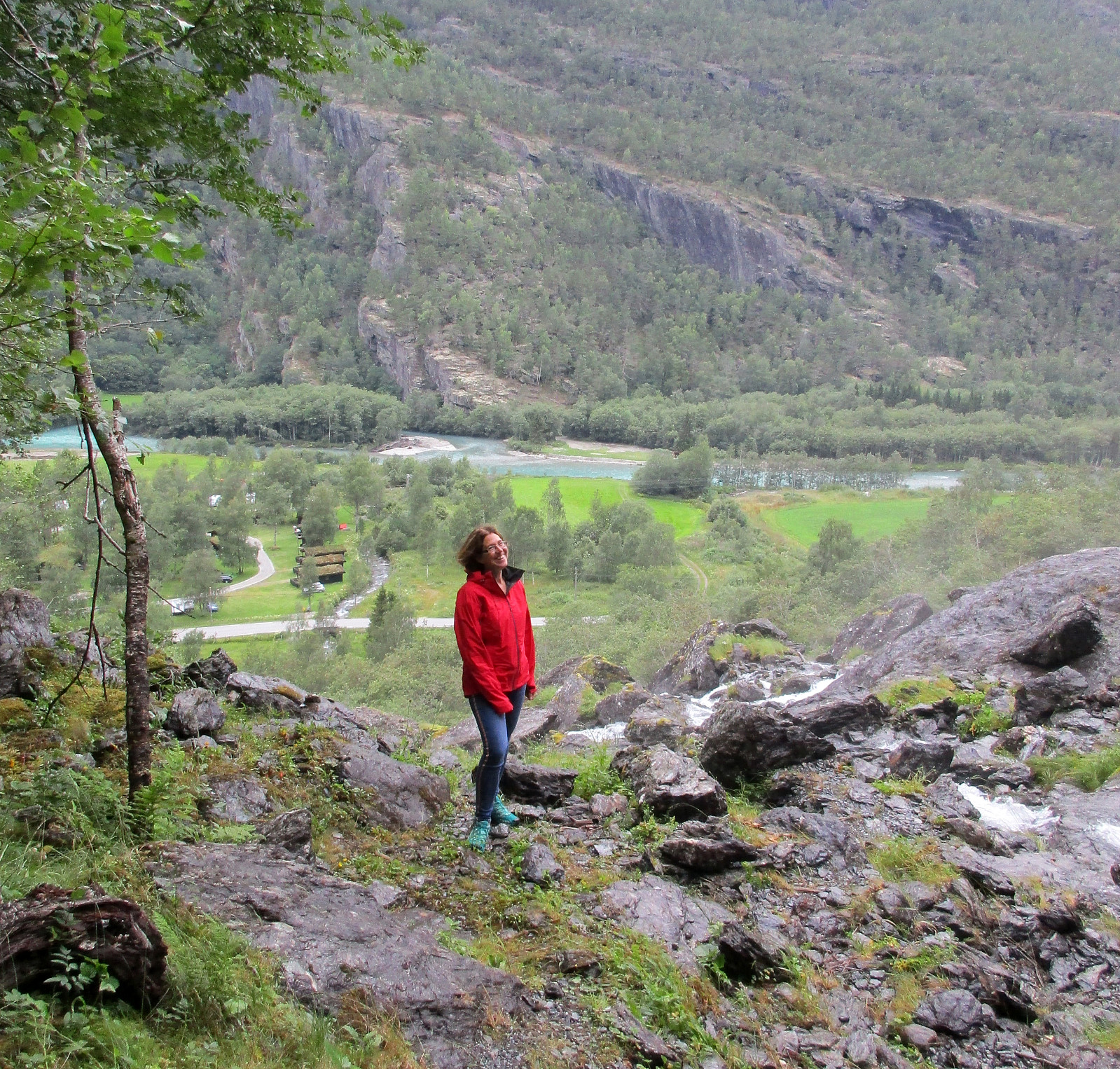
Rimstigfjellet via Rimstigen
- Dato:
- 26.08.2018
- Turtype:
- Fjelltur
- Turlengde:
- 6:00t
- Distanse:
- 10,2km
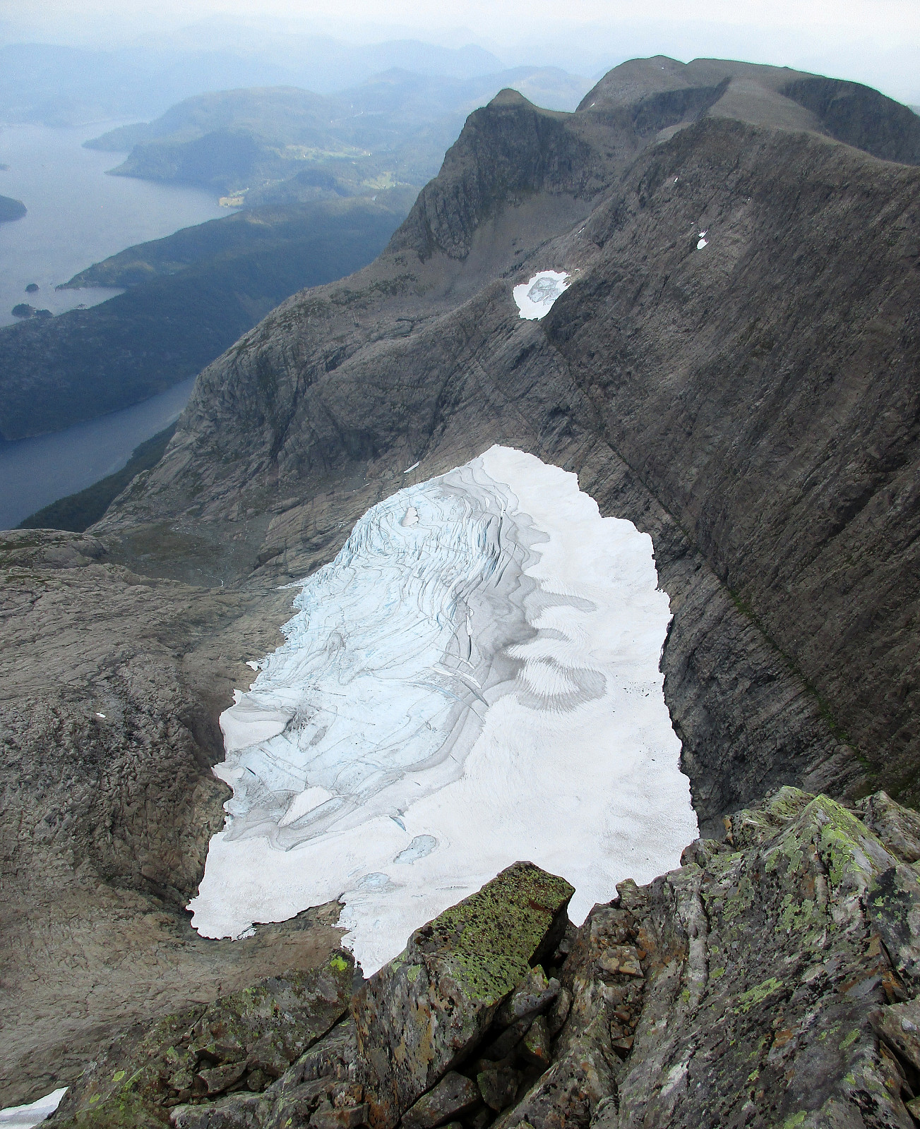
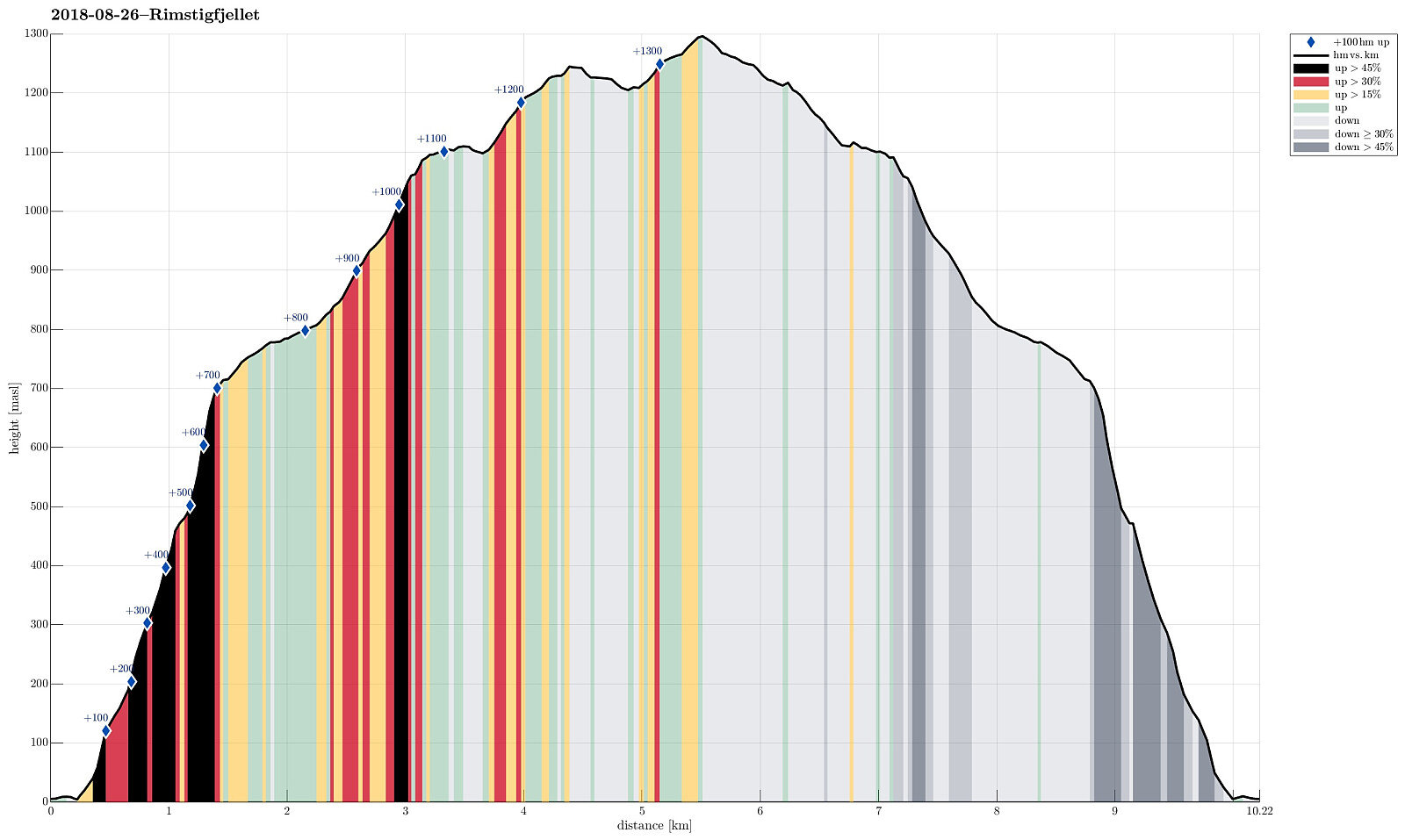 We took road E16 to Gudvangen first, before continuing from there towards Bakka on the western side of Nærøyfjorden. Only a short bit after Bakka, we found a good way to park next to the road. We then hiked the impressive Rimstigen up---what a path up through this very steep terrain right next to the fjord?! Wow! At about 700mosl, the path flattens out (a bit), leading into a side valley, exending westwards (and away from the fjord). Up there, it is really very lovely! After walking for short along a not so steep path, the trail heads up Skarsbakkane (steep again), right next to a little stream (also called Tufteelvi up there?) with a nice waterfall quite high up on the mountain side! At about 1100mosl, one gets over "the second step" in this hike, meeting Skarsvotni right >>>
